About Us
Vishwawalking explained
 Ratings Explained
Vishwawalks
Parks, etc.
Funky Places
Future walks
Food
Gear and Health
Get Lost
Good reads
Links
Plants - Animals
Right to Ramble
Site map
Contact us
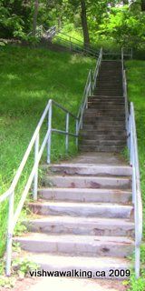
"Jacob's Ladder," a stairway in Port Hope, Ontario, leading up from Mill Street North at the bottom of town to just opposite St. Mark's church on King Street.
Photo: June 30, 2009

Westport, seen from Spy Rock Lookout in the Foley Mountain Conservation Area
(Right click to blow picture up)

Fontana Dam, North Carolina. The Appalachian Trail passes over the dam.
(Right lick on picture to enlarge.)

Nantahala Outdoor Centre (NOC), North Carolina. (Right click on picture to enlarge.)
Vishwawalking
Towns Along the Way
Below I have listed a few of the towns, village and cities within a rough 20-mile radius of trails, parks and sites of interest that I have walked.Canada
Ontario
AnsonCentral/south-eastern on Hoards Road, something short of 4.5 kilometres west of Stirling.
Not really a village (just a dot on the map now), but the Hastings Heritage Trail (whose next 16.5 kilometres north are shared by the Trans Canada Trail from this point) is crossed here by the Grand Junction Railway trail coming from Belleville via Stirling. From Anson the east-west Grand Junction trail is shared by the Trans Canada Trail.
Belleville
Central/south eastern, on Lake Ontario on the Highway #401 corridor.
The abandoned Grand Trunk Railway starts here, at the train station
The H.R. Frink Outdoor Education Centre is roughly 10 kilometres north of the city, just off Highway #37.
The Lake Ontario Watefront Trail runs through the city along the waterfront.
Bloomfield
Population 576. The population (at least between 2006 and 2021) has been actually dropping here. It's a beautiful little village, with the Millenium Trail running just to the south.
Bonarlaw
Central/south/eastern on Highway #14, 7.5 kilometres south of Marmora.
Not really a village even, but a crossroads of the Hastings Heritage Trail and the Trans Canada Trail. The Trans Canada turns south here, using the Hastings Heritage Trail. (all ATV-infested).
Camden East
Central south-eastern
Between (and north of) Napanee and Kingston, 7.6 kilometres north of County Road #4 and Highway #401.
The Cataraqi Trail runs across County road #4 just to the north of the village.
Campbellcroft
Central. Tiny village just east of Garden Hill on the Ganaraska Road (County Road #9).
The Ganaraska Trail runs through it.
Campbellford
Central/south eastern. North of Brighton.
The Trans Canada Trail runs through here.
Ferris Provincial Park is just to the south.
Ranney Falls suspension bridge spans the Trent River in the southern part of the town.
Carrying Place
South central, in Prince edward County ("The County.).
The Millenium Trail starts/ends here (Officially: there's more trail running north and east.)
Castleton
population 600. Twenty-one kilometres north of Highway #41 on Highway 25. South-central Ontario.In Cramahe Township. One of the eastern starting/ending points for the Oak Ridges Trail.
Cloyne
Central/south eastern. On highway #41, about 20 kilometres north of Kaladar and Highway #7. South of Bon Echo and the closest place to get supplies if you're visiting that park.
Corbyville
Central/south eastern
A small community north of Belleville (and now part of Belleville), once the home of Corby Distilleries. Sometimes called a "ghost town" although it's still very much alive.
The Grand Junction Railway trail runs through it.
Crookston
Central/south-eastern. A village/hamlet just off Highway #62
The Trail of Two Lakes runs through it (north to south).
The Trans Canada Trail runs just south of it. (An ATV-friendly section.). See Tweed to Bonarlaw
Eldorado
Central/south-eastern. Famous for its mini gold-rush in the 19th century. Now a modest collection of houses on Highway #62, north of Madoc, Ontario. The Hastings Heritage Trail crosses Highway #62 here.
Ernestown
South-eastern. A dot on the map (no real community) west of Kingston, on County Road #4 (Link Road).
Ernestown railway station. Abandoned building. (No walk is associated with this building.)
Frankford
Central/south/eastern. North of Trenton on Highway #33, 8.5 km north of Highway #401.
The Lower Trent Trail passes through it. Bata Island is on the northern fringes and the Frankford Tourist Park is on the Trent River.
Garden Hill
Central; small village on Ganaraska Road (County Road #9).
The Ganaraska Trail runs just to the east of the village.
Glen Ross
South-eastern, small village on the Trent River/canal
On Rosebush Road on the Trent River, 4.3 kilometres west of County Road #33. Trent-Severn Lock #7 is here.
The Hastings Heritage Trail starts/ends here, heading to the north.
Gosport
Village on Lake Ontario's shores. Near PresQu'ile park.
Harrowsmith
A town in Ontario, north of Kingston. The Cataraqui Trail passes through it, just to the south.
Hastings
Central south-eastern
South of Highway #7, south on Highway #45 (or north on #25 from Highway #401 at Colborne). On the Trent-Severn Waterway, just north of the north end of Rice Lake. The Trans Canada Trail, which is part of the Grand Junction Railway Trail, passes though it.
Kaladar
South-eastern on Highway #7.
The Trans Canada Trail runs through it. (An ATV-friendly section.) See Sharbot Lake to Kaladar and Kaladar to Tweed sections.
Kingston
South-east on the Lake Ontario waterfront. part of the Highway #401 corridor.
The Rideau Trail starts/ends here.
The K&P Trail starts here.
Lakefield
Central, north of Peterborough.
Katchewenatooka/Beach walk. "Imagine the marsh" Conservation area. (Otonabee Conservation Authority).
Lakefield cement factory. An abandoned factory ( An extreme adventure, not a Sunday walk.)
Madoc
Central/south-eastern at the crossroads of Highways #62 and #7.
O'Hara Mill Homstead & Conservation Area is northwest about six kilometres from town.
The Trans Canada Trail runs about 10 kilometres to the south. (An ATV-infested section.). See Tweed to Bonarlaw
The Trail of Two Lakes (ATV-friendly) runs through the western outskirts.
Madoc Junction
Central south-eastern
Now just a junction of two railbed trails, just north of Tuftsville Road, north of Belleville.
The Trail of Two Lakes (Belleville and North Hastings Railway Company) starts here.
The Grand Junction Railway trail out of Belleville runs through it.
Marlbank
Central, south-eastern
Site of the Marlbank cement factory, Marlbank, Ontario. Not a walk as it's right by the road.
Marmora
Central/south-eastern on Highway #7.
Naylor's Common Wetland and Trails. A small, neglected park. Nice marsh.
Marmora Mine. Great view of a human-made lake. The viewing cage allows a great one-perspective view. The tour part is an extreme adventure, not a Sunday walk.
The Hastings Heritage Trail passes nearby.
Napanee
This is the unofficial start of the 103-kilometre Cataraqui Trail, which has it's official southern terminus in a little village called Strathcona.
Niagara Falls
South-eastern, on the Niagara River, which connects lakes Erie and Ontario. Population: 50,000. A city of contrasts, it features one of the great wonders of the world, Niagara Falls. Surrounding the falls is a disgusting array of expensive touristy "attractions." North of the falls and elsewhere are beautiful parklands and some amazing sites (such as the Whirlpool Rapid, the botanical gardens, and a butterfly conservancy) Some parts of town are run-down and make for interesting walks. Other parts are gaudy and also make for interesting walks (look but don't touch). There are a number of trails close by, but the best known is the southern terminus of the Bruce Trail, which is situated at a cairn at Queenston Heights near General Brock's monument, along the western bank of the river, near the Lewiston Bridge to the U.s. (The park is 13 kilometres north of the falls and 9.5 kilometres from the train station on Bridge Street.
Newburgh
Central/south/eastern, on County Road #27, just east of County Road #1, nine kilometres north of Napanee.
The Cataraqui Trail runs just north of this picturesque village with many limestone and brick buildings.
Picton
Town in Prince Edward County, south of belleville. Population 4, 702 (2016). The Millenium Trail starts/ends just north and and runs west of here.
Prince Edward Heights, an abandoned institution for the mentally disabled was situated here.
Port Hope
Central, south, on the Highway #401 corridor (90 km. from #401 and the don valley in Toronto.)
The Ganaraska Hiking Trail begins here. The abandoned Nicholson file factory is here.
St. Catherines
S. Ontario. Population: 131,400 (2011). The Bruce Trail runs through the city. On the trail, some St. Catherines sights include the Old Welland Canal and Decew Falls, where Morningstar Mills is also located (these last two links are external).
Spring Brook
Central /south-eastern. The Hastings Heritage Trail runs by it. The same section is shared with the Trans Canada Trail.
Stirling
Central/south-eastern
The Grand Junction Railway trail runs through it, connecting to the north-south Hastings Heritage Trail, which runs to the west of it. West of Stirling, at Anson, the Grand Junction becomes part of the Trans Canada Trail.
Strathcona
Centra/south-eastern. Six kilometres north of Napanee and Highway #401, just off County Road #1, on County Road #16. (Strathcona is not noted on some popular maps.) Strathcona Paper is the centrepiece of this hamlet on the Napanee River, with a scattering of houses nearby.
Start of the Cataraqui Trail.
l
Sydenham
Frontenac County, Ontario (Not to be confused with the other Sydenham further west in Grey County.)
The CPR/Grand Trunk railway runs through the town. The rail bed makes up part of the Cataraqui Trail. The town has a beach in summer and a skating area it maintains on Sydenham Lake.
The Rideau Trail passes through here.
The Cataraqui Trail intersects the Rideau here.
Gould Conservation Area is just to the north
Frontenac Park is just to the north.
Sylvan Glen
Not a village or town, but a little conservation area near Port Hope on the Ganaraska River. The Ganaraska Trail runs through it.
Thomasburg
Central/south-eastern. On Highway #37, 19 kilometres north of the #401 at Belleville.
All my "corpus mundi" trails start from here.
Vanderwater Park is just to the east. Great trails.
Tobermory
Population 3,850. Northernmost town on the Bruce Peninsula and the terminus of the Bruce Trail. Tobermory Chamber of commerce site.
Trenton
Central/south-eastern. South of Highway #401, some 150 kilometres east of Toronto.
The Lake Ontario Waterfront Trail runs through it.
The Lower Trent Trail (unofficially) starts at the waterfront and officially on the northern outskirts.
Tweed
Population 6,44 the village, not the municipality). Central/south-eastern on Highway#37.
The Trans Canada Trail runs through it. (Tweed is something of a hub for ATVs on this trail.) See the
Kaladar to Tweed and Tweed to Bonarlaw sections. Famous for its painted fire hydrants.
Vanderwater Park is to the south off Highway #37, near Thomasburg.
Warkworth
Population 600 (in the village proper). South-central Ontario, south and a bit west of Campbellford. Twenty-two kilometres north of Highway #401.Take Highways #30 and head east on Highway #29. This town has drawn artistic types and it has an artsy flavour to it and a great small-town main street. It's one of the two eastern beginning points for the Oak Ridges Trail (the other is Castleton), which starts at the entrance to the Millenium Trail, a little park that feature lilacs.
Wellington
Population, 1,860. It's a popular town, situated in prince Edward county, with some estimates saying the population will double by 2032. The Millenium Trail passses just to the north and it is possible to see residential development happening in spots.
Westport
Central/south-eastern Ontario. It sits in the crux of Westport Sand Lake and Big Rideau Lake 58 kilometres (on Highway #10) from Kingston, Ontario. A beautiful historical and tourist town. Near Foley Mountain Conservation Area, and the Rideau Trail.
Whitney
A town just outside Algonquin Park, on the south side about halfway between the east and west borders of the park. It is on Highway #60. It's near a myriad of hiking trails in the park. see my Highlands Backpacking Trail report. External link: site of South Algonquin Township; lots of history here.
Quebec
Montreal
Dow/O'Keefe Brewery. An abandoned brewery. (An extreme urban adventure, not a Sunday walk.)
United States
Georgia
Atlanta
Biggest city (population 432,500) that is closest to the southern end of the Appalachian Trail. Most shuttles to Amicalola Falls State Park or Springer Mountain start here.
Dahlonega
Town close to Amicalola Falls State Park (Georgia Department of Natural resources site with s map of the park) and the southern end of the Appalachian Trail. It's about 18 miles (29 kilometres) east of the park.
Dawsonville
Town closest to the start of the Appalachian Trail and the county seat for Dawson County. This is the town's official site.
Hiawassee
Town of about 900, with motels and supplies for hikers on the Appalachian Trail. See David Miller's guide (or any detailed guide) for telephone numbers of people who will supply rides from either Unicoi Gap (mile 52.9 on the trail and 12 miles from town), or Dick's Gap (mile 69.6; 11 miles west of the trail).
Suches
Town 2 miles west of Woody Gap (mile 21) on the Appalachian Trail.
North Carolina
Fontana Dam and Fontana Village
The dam is on Fonana Lake. Travellers on the Appalachian Trail must cross it. The village has a resort (with special rates for hikers) and a general store with a laundromat and supplies. Near the dam is the "Fontana Hilton," a very classy shelter on the Appalachian Trail.
Franklin
Town with a population of about 3, 600. Ten miles east of Winding Stair Gap (mile 109.8) on the Appalachian Trail.
Nantahala Outdoor Centre
Affectionately known as "Noc." A complex near Bryson City with basic (and upscale) lodging for hikers on the Appalachian Trail. Situated on Hwys 16 and 74, it has restaurants, water sports and other amenities. The NOC site.
Maine
Millinocket
Nearest town to the end/start of the Appalachian Trail. On Highways #11, about 18 km from Highway #95.
Rangeley
Franklin County town closest to Wilhem Reich Museum. Pop. 1,168, but near summer/winter resorts.
Tennessee
Gatlinburg
Town 22 miles from Clingman's Dome, the highest point on the Appalachian Trail. The Grand Prix Motel (the link is to the motel's site) gives deals to hikers and has a laundromat. It's a tourist town with motels, restaurants, an excellent Ripley's aquarium, "hooch" testing emporiums, a fine local brewery and lots of other touristy things to do. Hikers can get a taxi ride to/from Knoxville to Gatlinburg for about $75.00.