About Us
Vishwawalking explained
 Ratings Explained
Vishwawalks
Day walks
Funky Places
Future walks
Food
Gear
Get Lost
Right to Ramble
Good reads
Site map
Links
Contact us
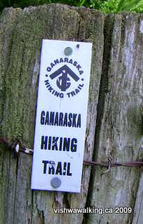
Ganaraska Hiking Trail sign at Sylven Glen.
The
Ganaraska Trail
Association turned 52 in 2021.
Two years before 1969, after the completion of the Bruce Trail from Niagara to Tobermory, plans began to make a trail that would eventually connect to the Bruce. The original idea was to follow the old Port Hope Lindsay and Beaverton rail line, which ended in Midland. However, because of private property issues, the trail has had to abandon the rail line north of Port Hope, taking up pieces of it farther north to Lindsay. The trail now runs from Port Hope through to "McKinney's Hill" just west of Glen Huron.
Indeed, at its end, the Ganaraska connects with the Bruce Trail at the 25.1 kilometre point in its Blue Mountain section. I haven't made that connection yet, but I know it will be a big moment when I do.
For those trying to follow using the Bruce and/or Ganaraska guidebooks, the end of the trail is described on page 24 in the 2006 Ganaraska guide book, with accompanying map 25. The Bruce guide book (Edition 25, 2008) describes it on the page after map 22, "Devil's Glen." I have spent more time than I care to admit poring over maps trying to find exactly where these places are in the guidebooks, so you non-guidebook types have to forgive me for lending a hand here. N.B.: these comments refer to older copies of both the Bruce and Ganaraska trail guides. The 2013 Ganaraska Trail guide can be purchased for $30 dollars from some outlets, plus mailing (this is the latest edition). Try Googling it: the trail association doesn't seem to sell it, and other outlets are "sold out." However, the association does have free PDFs of the book. This page encourages you to download the Ondago app, where you can download nine maps outlining the trail. This is particularly useful if your device has a GPS that can put you exactly where you are on the trail. I still like the handiness of the hard-copy colour topo maps the guidebook has. There are over 30 separate maps you can take out of the binder and only carry the maps you need. The latest Bruce Trail Guidebook (Edition 30, June 2020), can also be bought; I slog on with my old maps.
Today, the trail association has a number of clubs that take responsibility for sections of the trail and that put on various events in aid of the trail. You can find out what some of them are doing at the main Ganaraska Hiking Trail site. The "About Us" section is a way to get to a link that leads to what local clubs are doing. Other sections don't appear to have separate websites.
Trail markers are the standard white strips or blazes, usually painted on trees and poles (the same as the Oak Ridges Trail and the Appalachan Trail). If you see two markers above one another with one off to one side, it means you should turn in the direction of the upper offset marker. Some blazes are outlined by black paint. Blue markers indicate a side trail. Other marking methods are more instinctive: a rock cairn, coloured tape, or a blaze painted on a large rock. Remember to keep an eye out for the white blazes and don't follow a trail too far without making sure you've seen a blaze—it's sometimes too easy to merrily follow a track that is not part of the trail, but somehow looks like it should be its logical continuance. Also, I personally like the Rideau trail method of marking the north and the south blazes differently. I have walked the wrong way in the dark on the Appalachian Trail after getting turned around. We lost over two hours (two very dark hours in mature bush) by the time we figured out that we had walked in the wrong direction. Duh!
Walking involves reconnecting with your environment. All too often we map our geographic location by roads and towns. I am learning (or more precisely my walking is teaching me) that rivers and watersheds are better locators. Perhaps we should redesign our maps to do away with townships and counties and focus on watersheds.
I grew up in Port Hope. The Ganaraska River was a big part of my life as a kid. It was always there coursing through the lower part of town. In summer, we were drawn to it as a place to mess about. I never went fishing in it (although many do) and I've never canoed it, but I certainly have spent many hours splashing about in it. The Ganaraska empties into Lake Ontario just to the east of the Port Hope harbour, a site where I watched the fancy (and not-so-fancy) boats go in and out and occasionally got to row the huge boat the local sea scout group owned. I was fascinated by the big catfish slowly circling on the bottom of the lake at the end of the cement pier.
To the west of the harbour were industrial buildings, including the infamous Eldorado, a uranium mining and refining plant (now known as Cameco). Port Hope has ongoing heated discussions as to how much radiation-polluted dirt is actually spread around the town. How much I played in radiation-infested dirt and beach sand is an open question. I don't (yet) glow in the dark.
Back in the day, there was a swimmable beach west of the Eldorado plant. In the early 1960s, the beach became more and more polluted until it was no longer usable. The old wooden beach house with its snack counter and change rooms closed and was eventually torn down. Like many beaches and other natural places, the polluters had long ago made their millions and got out, leaving the rotting fish for others to clean up.
And who was there to blame? Everyone and no one. We kids retreated to the local pool, which cost a nominal amount to get in, was heavily chlorinated and had no sense of adventure. Certainly, spreading a towel on a hunk of cement was nowhere as fun as hanging out at the beach and being enclosed in a wire cage until you wanted to leave was a definite drag: there was no quick swim, play a game, run about more swimming, etc. There was only swimming and sitting on your towel. Once you left the pool, there was no getting back in.
 There
was still the Ganaraska ("the Gannie") for some free swimming. The muddy water in the
reaches north of the town didn't make for great swimming, but we sure
could wade back and forth in the rapids.
There
was still the Ganaraska ("the Gannie") for some free swimming. The muddy water in the
reaches north of the town didn't make for great swimming, but we sure
could wade back and forth in the rapids.
And so, the Ganaraska Hiking Trail (and the Lake Ontario Waterfront Trail, which I'll get to later) have particular connections for me.
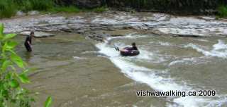
A couple of young guys playing with an inner tube in
the section of the Ganaraska River that flows through
Port Hope just opposite the library. June 30, 2009
I haven't yet walked the web of trails that will connect Port Hope and the Ganaraska River to where I live today, but I'll do that sometime. When I do, I'll have that real geographic connection (that's the Vishwawalking part) to all those memories I have of growing up. I'll put my ear to the ground so I can hear the rumbling of that last train as it pulls out of Port Hope in 1951 (before I lived there) over the trail bed I now walk, right near the beach where I hung out when I was a kid.
Nota bene: I have only hiked a few of the beginning sections of the Ganaraska Trail, but there are already discrepancies in information between the guidebook, the web and what's out there. I'll note these when I run into them. It's a tough go for volunteers trying to keep up with it all, so I have the utmost respect for those unpaid and often unsung heroes. The website provides rerouting updates but keep an eye out for rerouting that hasn't yet made the site.
Two years before 1969, after the completion of the Bruce Trail from Niagara to Tobermory, plans began to make a trail that would eventually connect to the Bruce. The original idea was to follow the old Port Hope Lindsay and Beaverton rail line, which ended in Midland. However, because of private property issues, the trail has had to abandon the rail line north of Port Hope, taking up pieces of it farther north to Lindsay. The trail now runs from Port Hope through to "McKinney's Hill" just west of Glen Huron.
Indeed, at its end, the Ganaraska connects with the Bruce Trail at the 25.1 kilometre point in its Blue Mountain section. I haven't made that connection yet, but I know it will be a big moment when I do.
For those trying to follow using the Bruce and/or Ganaraska guidebooks, the end of the trail is described on page 24 in the 2006 Ganaraska guide book, with accompanying map 25. The Bruce guide book (Edition 25, 2008) describes it on the page after map 22, "Devil's Glen." I have spent more time than I care to admit poring over maps trying to find exactly where these places are in the guidebooks, so you non-guidebook types have to forgive me for lending a hand here. N.B.: these comments refer to older copies of both the Bruce and Ganaraska trail guides. The 2013 Ganaraska Trail guide can be purchased for $30 dollars from some outlets, plus mailing (this is the latest edition). Try Googling it: the trail association doesn't seem to sell it, and other outlets are "sold out." However, the association does have free PDFs of the book. This page encourages you to download the Ondago app, where you can download nine maps outlining the trail. This is particularly useful if your device has a GPS that can put you exactly where you are on the trail. I still like the handiness of the hard-copy colour topo maps the guidebook has. There are over 30 separate maps you can take out of the binder and only carry the maps you need. The latest Bruce Trail Guidebook (Edition 30, June 2020), can also be bought; I slog on with my old maps.
Today, the trail association has a number of clubs that take responsibility for sections of the trail and that put on various events in aid of the trail. You can find out what some of them are doing at the main Ganaraska Hiking Trail site. The "About Us" section is a way to get to a link that leads to what local clubs are doing. Other sections don't appear to have separate websites.
Trail markers are the standard white strips or blazes, usually painted on trees and poles (the same as the Oak Ridges Trail and the Appalachan Trail). If you see two markers above one another with one off to one side, it means you should turn in the direction of the upper offset marker. Some blazes are outlined by black paint. Blue markers indicate a side trail. Other marking methods are more instinctive: a rock cairn, coloured tape, or a blaze painted on a large rock. Remember to keep an eye out for the white blazes and don't follow a trail too far without making sure you've seen a blaze—it's sometimes too easy to merrily follow a track that is not part of the trail, but somehow looks like it should be its logical continuance. Also, I personally like the Rideau trail method of marking the north and the south blazes differently. I have walked the wrong way in the dark on the Appalachian Trail after getting turned around. We lost over two hours (two very dark hours in mature bush) by the time we figured out that we had walked in the wrong direction. Duh!
Walking involves reconnecting with your environment. All too often we map our geographic location by roads and towns. I am learning (or more precisely my walking is teaching me) that rivers and watersheds are better locators. Perhaps we should redesign our maps to do away with townships and counties and focus on watersheds.
I grew up in Port Hope. The Ganaraska River was a big part of my life as a kid. It was always there coursing through the lower part of town. In summer, we were drawn to it as a place to mess about. I never went fishing in it (although many do) and I've never canoed it, but I certainly have spent many hours splashing about in it. The Ganaraska empties into Lake Ontario just to the east of the Port Hope harbour, a site where I watched the fancy (and not-so-fancy) boats go in and out and occasionally got to row the huge boat the local sea scout group owned. I was fascinated by the big catfish slowly circling on the bottom of the lake at the end of the cement pier.
To the west of the harbour were industrial buildings, including the infamous Eldorado, a uranium mining and refining plant (now known as Cameco). Port Hope has ongoing heated discussions as to how much radiation-polluted dirt is actually spread around the town. How much I played in radiation-infested dirt and beach sand is an open question. I don't (yet) glow in the dark.
Back in the day, there was a swimmable beach west of the Eldorado plant. In the early 1960s, the beach became more and more polluted until it was no longer usable. The old wooden beach house with its snack counter and change rooms closed and was eventually torn down. Like many beaches and other natural places, the polluters had long ago made their millions and got out, leaving the rotting fish for others to clean up.
And who was there to blame? Everyone and no one. We kids retreated to the local pool, which cost a nominal amount to get in, was heavily chlorinated and had no sense of adventure. Certainly, spreading a towel on a hunk of cement was nowhere as fun as hanging out at the beach and being enclosed in a wire cage until you wanted to leave was a definite drag: there was no quick swim, play a game, run about more swimming, etc. There was only swimming and sitting on your towel. Once you left the pool, there was no getting back in.
There
was still the Ganaraska ("the Gannie") for some free swimming. The muddy water in the
reaches north of the town didn't make for great swimming, but we sure
could wade back and forth in the rapids. And so, the Ganaraska Hiking Trail (and the Lake Ontario Waterfront Trail, which I'll get to later) have particular connections for me.
A couple of young guys playing with an inner tube in
the section of the Ganaraska River that flows through
Port Hope just opposite the library. June 30, 2009
I haven't yet walked the web of trails that will connect Port Hope and the Ganaraska River to where I live today, but I'll do that sometime. When I do, I'll have that real geographic connection (that's the Vishwawalking part) to all those memories I have of growing up. I'll put my ear to the ground so I can hear the rumbling of that last train as it pulls out of Port Hope in 1951 (before I lived there) over the trail bed I now walk, right near the beach where I hung out when I was a kid.
Nota bene: I have only hiked a few of the beginning sections of the Ganaraska Trail, but there are already discrepancies in information between the guidebook, the web and what's out there. I'll note these when I run into them. It's a tough go for volunteers trying to keep up with it all, so I have the utmost respect for those unpaid and often unsung heroes. The website provides rerouting updates but keep an eye out for rerouting that hasn't yet made the site.
1) Ganaraska Trail. Start
(Port Hope) to Hope Township 7th Line
2) Ganaraska Trail: 7th Line to Ganaraska Forest
2) Ganaraska Trail: 7th Line to Ganaraska Forest
Home | Contact Us | Site Map
Page
created: July 3, 2009
Updated: September 8,2021, 2021
Updated: September 8,2021, 2021