About Us
Vishwawalking explained
 Ratings Explained
Vishwawalks
Day walks
Funky Places
Future walks
Food
Gear
Get Lost
Right to Ramble
Good reads
Site map
Links
Contact us
Vishwawalking
Rails to trails
 In
walking trails
that use old rail beds, I have become interested in the history
of old rail lines. Their history is confusing
and
connecting the physical lines to their one-time owners can be
difficult, especially as companies were bought out or amalgamated.
However, there are enthusiasts out there who have chronicled
dates and names that may help put the puzzle together. On this page, I
have collected some information and listed some useful links that may
help walkers enrich their adventures.
In
walking trails
that use old rail beds, I have become interested in the history
of old rail lines. Their history is confusing
and
connecting the physical lines to their one-time owners can be
difficult, especially as companies were bought out or amalgamated.
However, there are enthusiasts out there who have chronicled
dates and names that may help put the puzzle together. On this page, I
have collected some information and listed some useful links that may
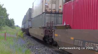
help walkers enrich their adventures.A train running next to the Tottenham Tract of the Simcoe
County Forests, northwest crossing, at the 2nd Line, July 8, 2009.
To avoid encumbering a page with citations, I don't always list my references specifically (shame, shame!), unless of course I quote directly. However, I do sprinkle my pages with links which are a good hint that I have used the page, and all my sources are acknowledged somewhere. I have drawn liberally from the links below and would like to acknowledge the incredible research some railway enthusiasts indulge in.
As I have often noted, the attraction of some rails to trails are greatly reduced by the presence of recreational vehicles. As the TCTrail Blogspot noted re the Hastings Heritage Trail, "In 2004, the ballast was still deep and biking or running was difficult." This is certainly not the case in all sections, but in 2012, not much has changed. Indeed, large gravel (ballast) is sometimes laid down to aid ATV travel; the trail operators focus on motorized recreational vehicles so the "multiuse" designation doesn't have much credibility. Trail managers are aware of this and in 2021, the situation has improved considerably. Historically these routes are fascinating and they go through long stretches of beautiful countryside. A few (for example the Lower Trent Trail and the Cataraqui Trail) ban ATVs.
Canada
Ontario:
These descriptions are largely limited to trails I have described, or are closely connected to the same. Unless obviously stated, the trail links are to my descriptions.
Bay of Quinte Navigation and Railway Company — see Bay of Quinte Railway
Bay of Quinte Railway
Cataraqui Trail
"Built by lumberman Edward Rathbun, the Bay of Quinte Railway (B&Q) ran in a crescent-shaped arc eastward from Napanee to Yarker, then north and west through Tweed, Actinolite and Queensborough. Its western terminus was at Bannockburn, where it intersected with the Central Ontario Railway. The remains of a turntable, an engine house and a station platform can still be found among the trees just west of Highway 62." — from Heritage Atlas of Hastings County. From Yarker, the B&Q also ran north to Harrowsmith and beyond.
The section of trail that now is the Cataraqui was eventually known as the Smith Falls subdivision and was the creation of a number of companies that bought and sold rail line through the 19th and 20th century.
In 1879, the Napanee, Tamworth and Quebec (NT&Q) Railway was incorporated. In 1883, Edward Rathbun gained control of the company and in August of 1884, the line between Napanee and Yarker was opened. In the same year and month the line from Yarker to Tamworth, stretching westward (and not a part of the Cataraqui Trail), was opened.
In 1889, the rail was extended from Yarker to Harrowsmith. In 1890, the NT&Q was reorganized and became the Kingston Napanee and Western (KN&W) Railway. In 1891, they subsequently leased the line to the Bay of Quinte Railway and Navigation Company (BQR&N). In 1893, KN&W extended the line from Harrowsmith to Sydenham. In 1897, the KN&W amalgamated with the BQR&N and became the Bay of Quinte Railway .
The BQR&N was incorporated in 1881 and in the same year ran a line 5.6 kilometres (3.5 miles) north from Deseronto to Deseronto Junction to connect with the east-west grand Trunk Railway. So, in 1897, when it became part of the BQR, it was able to run a train from Deseronto, through to Napanee, Strathcona, Newburgh, Yarker, Harrowsmith and Sydenham, requiring a stretch of the Grand Trunk Railway to make the connection. In 1907, they built their own line from Deseronto Junction to Napanee.
In June, 1910, Mackenzie and Mann bought the B&Q for their Canadian Northern Ontario Railway, which was part of their larger Canadian Northern railway. They upgraded the tracks from Deseronto to Sydenham and in 1918 the line became part of the Toronto to Ottawa mainline. In the same year, the company was transferred to the Canadian National Railway.
The Canadian Northern Ontario Railway built the Sydenham to Hurdman (near Ottawa) section of the rail bed in December 1913. It was a tough 138-kilometre (86-mile) section carved out of the Canadian Shield, but today, the payback is a fine section of rail bed to walk on, at least to Smith Falls..
Through all this, the Government of Canada was involved in shoring up railway companies that fell into debt. Because it was an essential service, the government couldn't afford to let them fold. The building of these railways was a huge public affair as well. The Canadian people had a huge hand in maintaining and building our early systems of travel. Some capitalists made money from their railway endeavours ("pioneers," etc. etc.) but bailed (often with their money) when their businesses threatened to die, leaving the Canadian people holding the bag. Despite colourful myths about rugged individualists carving out our rail system, much of it was shored up by public money.
Most of the above information (sans the soapboxing) is from the "Railway Bob" site. A really excellent history of the B&Q and the Canadian Northern Ontario Railway can be found here. (This is an old archived page (updated in 1997), so you may have to work at making some links work between pages, using archive.org. They're there. Use the search function in archive.org to search for any date of the page if a link comes up as not found.)
Belleville and North Hastings Railway
The Trail of Two Lakes
This company was incorporated in 1874 and built a line from Madoc Junction just west of Highway #62, north of Belleville to connect with the Central Ontario Railway just west of Eldorado (on Highway #62). The line was opened in 1880, the same year it was sold to the Grand Junction Railway, but the Madoc to Eldorado section closed in 1893.
Canadian Northern Ontario Railway
This is a railway that was built to run between Toronto and Ottawa. See the Bay of Quinte Railway (above) for how it relates to the Cataraqui Trail between Sydenham and Smith Falls. The latter section was abandoned by Canadian National Railway in 1986.
See archived pages to The Ontario Railway History Page for a more complete history.
Central Ontario Railway
Lower Trent Trail
Hastings Heritage Trail
The Central Ontario Railroad started as the Prince Edward County Railroad. They ran a line from Picton (in the south) to Trenton. in 1879. In 1882 they reorganized as the Central Ontario Railroad and continued the line northward to Marmora in 1883 and a year later to Ormsby. By 1900, the line extended to Bancroft, to Maynooth in 1907 and Wallace by 1911. By 1984, the entire line had been abandoned.
"The Maynooth subdivision was constructed as the Central Ontario railway through to Eldorado by 1884 and eventually on to Wallace by 1911" (TCTrail blogspot). Wallace is about 14 miles short of Whitney, where the line was originally destined to go, to serve a lumber mill there.
While the railway served it it, Wallace was a centre for shipping goods south and receiving supplies from the south. here's an excerpt from the Soth Algonquin Township website (the page no longer exists, so the quote below is all that remains):
"Wallace was considered as the Polish settlement of Sabine Township, with many of the settlers being 'Kashub' people, from the border of old Imperial Prussia, presently known as Poland. The Polish families came to Wallace shortly after the railway arrived, around l911. At that time Wallace had become a shipping point for a handful of farmers and a bit of lumber. It got its name from the survey engineer of the line, Mr. Wallace.
"As the Polish immigrants were Roman Catholic, they were served by irregular visits from the priest of Whitney. Around 1937 service was being held in part of John Craftchick’s store on a regular basis, until 1940 when a mission church was built. A community centre was built beside the church a few years later.
"From 1943 to 1952, McRae hauled his lumber by truck, from his mill at Hay Lake to Wallace, where it was loaded on the boxcars and shipped out. In the 50,s, every Wednesday the train would arrive, bring in deliveries, stop for an hour, turn around at the “Y” beside Joseph Lavalley’s farm, and head back with the loaded boxcars
" By l960 the line between Lake St. Peter and Wallace was shut down. Approximately the same time in 1960 the church was closed and torn down. Presently the graveyard is still maintained by local residents. The community centre is owned by the Lavalley family, and still in used to hold their family events."
Grand Junction Railway
Grand Junction Railway (Belleville to points north)
Originally known as the Grand Junction Railroad Company when it was incorporated in 1852, it changed its name to the Grand Junction Railway in 1870.
In 1877 it opened a line from Belleville to Stirling, then pushed it gradually westward and northward to Campbellford, Hastings and Peterborough.
A great 1877 article in the Canadian Craftsman (alas, this link is no longer available online) tells of the first train that ran between Belleville and Stirling. The writer notes that the "train thundered along at 20 miles per hour," but despite the breakneck speed, "there was no apprehension of danger." In fact, this article states that what killed this line and the Belleville and North Hastings Railroad was its inability to handle trains going much faster than this. Keith Hanson, author of the very fine book, Last Trains From Lindsay, says that is wrong. Judging from his expertise, I'd go with his explanation. In an email to me he notes:
Grand Trunk Railway
Lake Ontario Waterfront (sections in Tyendinaga)
This was a network of railroads throughout Ontario and Québec. Canadians without a financial interest in the railroad ran it, while British financiers invested in it. It was never run well and was eventually expropriated by the Canadian government in 1923 and incorporated into the Canadian National Railways.
It was incorporated in 1853 and from 1855 onward began the operation of the main line line from Montréal to Brockville, gradually extending it westward.
Kingston Napanee and Western — see Bay of Quinte railway
Kingston and Pembroke Railway
Kingston and Pembroke Trail
Construction on the Kingston and Pembroke Railway was incorporated in 1871 and work began on it in 1872. Businessmen behind the project wanted to get access to mining and logging operations to the north. By 1876, the line stretched from Kingston to Sharbot Lake. With the opening of other lines, the pressure was off as far as getting to Pembroke was concerned. Still, work on the line continued and in 1884, it stretched to Calabogie and shortly afterwards to Renfrew, which is as close as it actually got to Pembroke. Total track stretched about 103 miles. Work was also done to extend the line south through Kingston to the shores of Lake Ontario. In 1912, Canadian Pacific took undertook a 999-year lease on the line.
"Under the Canadian Pacific, the line became known as the Kingston Subdivision. The entire line has been abandoned in the following manner: Snow Road to Calabogie in January 1962, Tichborne to Sharbot Lake in February 1964, Sharbot Lake to Snow Road in September 1966, Calabogie to Renfrew Junction in February 1977, and from Kingston to Tichborne in 1986." (From the K&P groups's history page, which no longer exists. Try this link for more history.) Bell Canada purchased the right of way on the line in the same year.
Between 1986 and 2002 negotiations continued as groups sought to retain the line for recreational use. At one point the local conservation authority was suggested as an owner, but it turned down the request for lack of funds and personnel to maintain the trail. The City of Kingston bought the rail bed and on December 6, 2007 the first section of the trail opened.
There are now three sections of the trail that are not yet connected. Section one starts in Kingston (see the link above to my page for details) and ends at tichborne, north of Sydney. It shares parts of the trail with the cataraqui and the Rideau trails.) Section two runs from Wilbur to Barryvale and is 32 kilometres long. Section three starts at Calabogie and runs north 21 kilometres to Renfrew. I have walked the trail from Kingston to Orser Road, back in 2009, when it was the only section of the trail open.
Napanee, Tamworth and Quebec (NT&Q) — see Bay of Quinte Railway.
Ontario and Québec Railway
Trans Canada Trail, (Sections from Glen Ross [Perth] to Bonarlaw)
"The Ontario & Quebec Railway (reincorporated in May 1881) built their mainline from Perth through Tweed, Havelock, Peterborough, Agincourt, Leaside, North Toronto to Toronto Junction (West Toronto), 199 miles, with 60-lb. rail on gravel ballast and a maximum grade of 1.1%. While the last spike was driven May 5,1884 a troublesome sinkhole near Kaladar prevented the start of passenger service until August 11th. The line down the Don was not built until 1893 providing a direct line down to Union Station; prior to this time they had to back their trains down from the Junction" (Old Time Trains).
In 1884, the Canadian Pacific Railway gained control of the O&QR, so it really was largely a subsidiary of CPR. The latter company built and ran the line from Perth to Toronto.
Port Hope Lindsay and Beaverton Railway
Part of the initial Ganaraska Trail. (Parts of southern sections of this rail bed are now bypassed by the trail because of private property issues.)
In 1846, a group was given the Port Hope to Peterborough Railway, but did not have funds enough to carry out the project. In 1853, a group of largely the same men organized the Port Hope and Lindsay Railway. Much of Port Hope's scramble to get a railway up and running was in response to railways being built northward from Cobourg, just a few miles to the east on Lake Ontario's shores. However, it was not until 1856 that the railway began being constructed, with the first tracks being laid across Port Hope's Main Street (Walton) in that year. The company had been organized once more and was now called the Port Hope Lindsay and Beaverton Railway. A month later an official opening excursion was taken to Millbrook and on October 16, 1857, the first train pulled into the Lindsay station.
In 1869, the railway was called the Midland Railway of Canada and had been extended to Beaverton on Lake Simcoe. An extension was made to Orillia in 1873 and to Midland in 1878. In 1893, an act of parliament made the line part of the Grand Trunk system and following that the Canadian National Railway System.
The line was always on the brink of financial disaster. here's a story from the July 5, 1859 Evening Guide (the local paper in Port Hope): " Mr. John Fowler [one of the railway owners] announced last week that he would run an excursion train to Peterborough on the ' Fourth' and that the charge per head for the trip to and fro would be the moderate sum of 50 cents. The train from Peterboro [sic] arrived at the usual hour, the band which accompanied it playing ' Yankee Doodle.' 9.30 A. M. was the time fixed to leave for Peterboro' but alas for the pleasure-seekers who had assembled at the station, when the fingers of the Town Clock pointed in that direction, Mr. Deputy Sheriff Benson by virtue of an execution against the goods and chattels of the lessee took possession of the ' Queen ' (engine.) About eleven o'clock the locomotive ' Clifton' was procured from Mr. Superintendent Williams of the Lindsay Line and being harnessed to the Peterboro' train, those who had hung about the station for two mortal hours were soon speeding rapidly northward."
The last passenger train ran this line to Peterborough in 1951, and other sections ran train sporadically until
the mid-1970s. Today, as any walker can observe wandering through parts of the line north of Port Hope, much of the rail bed has disappeared or is in private hands. The Ganaraska Trail uses it on and off as best it can; some sections of the rail bed the trail is on are quite overgrown.
The failure to keep this line open is a testament to the short-sight (and greed) of business and government interests. The failure to keep this section of the rail bed in public hands is disgusting.
Sources: Steampower Publishing has an excellent history, with a promise to publish a book detailing the the history of this line. Ted Rafuse is behind this. Wikipedia has a somewhat jumbled article, but it has some interesting points.
Links:
Hands down the best book on trains in south-central Ontario is Keith Hanson's Last Trains from Lindsay, Sandy Flats Publications, RR#1, Roseneath, Ontario, K0K 2X0, 1997. It may be hard to buy: it's listed as costing $75. Amazon has it listed at $200, Abebooks for considerably less. The Port Hope and the Cobourg libraries have it. It has a very readable and idiosyncratic style, fantastic photographs and maps of where buildings once stood. When you're walking it helps to locate, say, a long-gone train station; if you look hard you may find only a few bits of concrete, but hey, — you're in the station!
Ted Rafuse in Port Hope has a company called Steampower Publishing which puts out books on trains (Don't mix it up with Steampowerpublishing.com,. which deals with roleplaying games!)
Charles Cooper's Railway Pages has an informative site. Charles has written a couple of books and has a page that keeps up with railway publications.
The Ontario Railway History Page has excellent histories of Ontario companies and lines as well as lists of where old stations are or where. Unfortunately, it seems to no longer to exist; the link above is to archive.org where a 2001 version of the site can be seen. This means you sometimes have to work at getting to some of this site's links. They're there. Be creative.
Colin Churcher's Railway Pages concentrate on the Ottawa region where he lives, but he gets around, with railway articles on places as far flung as Chile and Spain.
CNR in Ontario: Railway Station Reports has good information on old railway stations in Ontario.
Narrow Gauge Through the Bush is a web page about narrow gauge lines in the Toronto, Grey and Bruce and Nipissing areas. I have not walked any of the trails described, but the information on early rails is informative.
The Ontario Railways History page had lots of great dates and other historical information. It has recently (as of June, 2009) disappeared. Let's hope it resurfaces elsewhere.
Canadian National Railway - Wikipedia. This is a good overview of the historical and contemporary state of the once-public now privately-owned company.
Railways of Eastern Ontario is an invaluable link, with histories of railway companies in eastern Ontario and an excellent list of links to explore. Check out the Grand Trunk page. I have used this page extensively for information above, especially for dates and connections between companies.
Railway Museum of Eastern Ontario. This is the place to visit if you like museums. It's on 90 William Street West in Smith Falls, Ontario. The town is east of Perth and north of Gananoque and Brockville. I haven't seen this museum, but the website, parts of which are still being built, is informative and chatty, with notes on what volunteers are up to.
The Alberta Railway Museum has an extensive about railways and the like in Canada.
These descriptions are largely limited to trails I have described, or are closely connected to the same. Unless obviously stated, the trail links are to my descriptions.
Bay of Quinte Navigation and Railway Company — see Bay of Quinte Railway
Bay of Quinte Railway
Cataraqui Trail
"Built by lumberman Edward Rathbun, the Bay of Quinte Railway (B&Q) ran in a crescent-shaped arc eastward from Napanee to Yarker, then north and west through Tweed, Actinolite and Queensborough. Its western terminus was at Bannockburn, where it intersected with the Central Ontario Railway. The remains of a turntable, an engine house and a station platform can still be found among the trees just west of Highway 62." — from Heritage Atlas of Hastings County. From Yarker, the B&Q also ran north to Harrowsmith and beyond.
The section of trail that now is the Cataraqui was eventually known as the Smith Falls subdivision and was the creation of a number of companies that bought and sold rail line through the 19th and 20th century.
In 1879, the Napanee, Tamworth and Quebec (NT&Q) Railway was incorporated. In 1883, Edward Rathbun gained control of the company and in August of 1884, the line between Napanee and Yarker was opened. In the same year and month the line from Yarker to Tamworth, stretching westward (and not a part of the Cataraqui Trail), was opened.
In 1889, the rail was extended from Yarker to Harrowsmith. In 1890, the NT&Q was reorganized and became the Kingston Napanee and Western (KN&W) Railway. In 1891, they subsequently leased the line to the Bay of Quinte Railway and Navigation Company (BQR&N). In 1893, KN&W extended the line from Harrowsmith to Sydenham. In 1897, the KN&W amalgamated with the BQR&N and became the Bay of Quinte Railway .
The BQR&N was incorporated in 1881 and in the same year ran a line 5.6 kilometres (3.5 miles) north from Deseronto to Deseronto Junction to connect with the east-west grand Trunk Railway. So, in 1897, when it became part of the BQR, it was able to run a train from Deseronto, through to Napanee, Strathcona, Newburgh, Yarker, Harrowsmith and Sydenham, requiring a stretch of the Grand Trunk Railway to make the connection. In 1907, they built their own line from Deseronto Junction to Napanee.
In June, 1910, Mackenzie and Mann bought the B&Q for their Canadian Northern Ontario Railway, which was part of their larger Canadian Northern railway. They upgraded the tracks from Deseronto to Sydenham and in 1918 the line became part of the Toronto to Ottawa mainline. In the same year, the company was transferred to the Canadian National Railway.
The Canadian Northern Ontario Railway built the Sydenham to Hurdman (near Ottawa) section of the rail bed in December 1913. It was a tough 138-kilometre (86-mile) section carved out of the Canadian Shield, but today, the payback is a fine section of rail bed to walk on, at least to Smith Falls..
Through all this, the Government of Canada was involved in shoring up railway companies that fell into debt. Because it was an essential service, the government couldn't afford to let them fold. The building of these railways was a huge public affair as well. The Canadian people had a huge hand in maintaining and building our early systems of travel. Some capitalists made money from their railway endeavours ("pioneers," etc. etc.) but bailed (often with their money) when their businesses threatened to die, leaving the Canadian people holding the bag. Despite colourful myths about rugged individualists carving out our rail system, much of it was shored up by public money.
Most of the above information (sans the soapboxing) is from the "Railway Bob" site. A really excellent history of the B&Q and the Canadian Northern Ontario Railway can be found here. (This is an old archived page (updated in 1997), so you may have to work at making some links work between pages, using archive.org. They're there. Use the search function in archive.org to search for any date of the page if a link comes up as not found.)
Belleville and North Hastings Railway
The Trail of Two Lakes
This company was incorporated in 1874 and built a line from Madoc Junction just west of Highway #62, north of Belleville to connect with the Central Ontario Railway just west of Eldorado (on Highway #62). The line was opened in 1880, the same year it was sold to the Grand Junction Railway, but the Madoc to Eldorado section closed in 1893.
Canadian Northern Ontario Railway
This is a railway that was built to run between Toronto and Ottawa. See the Bay of Quinte Railway (above) for how it relates to the Cataraqui Trail between Sydenham and Smith Falls. The latter section was abandoned by Canadian National Railway in 1986.
See archived pages to The Ontario Railway History Page for a more complete history.
Central Ontario Railway
Lower Trent Trail
Hastings Heritage Trail
The Central Ontario Railroad started as the Prince Edward County Railroad. They ran a line from Picton (in the south) to Trenton. in 1879. In 1882 they reorganized as the Central Ontario Railroad and continued the line northward to Marmora in 1883 and a year later to Ormsby. By 1900, the line extended to Bancroft, to Maynooth in 1907 and Wallace by 1911. By 1984, the entire line had been abandoned.
"The Maynooth subdivision was constructed as the Central Ontario railway through to Eldorado by 1884 and eventually on to Wallace by 1911" (TCTrail blogspot). Wallace is about 14 miles short of Whitney, where the line was originally destined to go, to serve a lumber mill there.
While the railway served it it, Wallace was a centre for shipping goods south and receiving supplies from the south. here's an excerpt from the Soth Algonquin Township website (the page no longer exists, so the quote below is all that remains):
"Wallace was considered as the Polish settlement of Sabine Township, with many of the settlers being 'Kashub' people, from the border of old Imperial Prussia, presently known as Poland. The Polish families came to Wallace shortly after the railway arrived, around l911. At that time Wallace had become a shipping point for a handful of farmers and a bit of lumber. It got its name from the survey engineer of the line, Mr. Wallace.
"As the Polish immigrants were Roman Catholic, they were served by irregular visits from the priest of Whitney. Around 1937 service was being held in part of John Craftchick’s store on a regular basis, until 1940 when a mission church was built. A community centre was built beside the church a few years later.
"From 1943 to 1952, McRae hauled his lumber by truck, from his mill at Hay Lake to Wallace, where it was loaded on the boxcars and shipped out. In the 50,s, every Wednesday the train would arrive, bring in deliveries, stop for an hour, turn around at the “Y” beside Joseph Lavalley’s farm, and head back with the loaded boxcars
" By l960 the line between Lake St. Peter and Wallace was shut down. Approximately the same time in 1960 the church was closed and torn down. Presently the graveyard is still maintained by local residents. The community centre is owned by the Lavalley family, and still in used to hold their family events."
Grand Junction Railway
Grand Junction Railway (Belleville to points north)
Originally known as the Grand Junction Railroad Company when it was incorporated in 1852, it changed its name to the Grand Junction Railway in 1870.
In 1877 it opened a line from Belleville to Stirling, then pushed it gradually westward and northward to Campbellford, Hastings and Peterborough.
A great 1877 article in the Canadian Craftsman (alas, this link is no longer available online) tells of the first train that ran between Belleville and Stirling. The writer notes that the "train thundered along at 20 miles per hour," but despite the breakneck speed, "there was no apprehension of danger." In fact, this article states that what killed this line and the Belleville and North Hastings Railroad was its inability to handle trains going much faster than this. Keith Hanson, author of the very fine book, Last Trains From Lindsay, says that is wrong. Judging from his expertise, I'd go with his explanation. In an email to me he notes:
"The Madoc line was closed when an inspection on April 12, 1983 declared the bridge over Hwy 62 at Moira Lake to be impassable. It required extensive repairs which were not justified in view of the volume of traffic (a few carloads of talc) on the line. A road to rail transfer at Belleville now handles some mine traffic coming out of the Madoc area.
The Grand Junction, which became part of a CNR loop line from Belleville to Toronto via Lindsay, was abandoned in 1987. With no customers between Belleville and Peterborough the CNR had elected to serve its small customer base in Peterborough by providing service from Toronto via Lindsay. " Thanks, Keith. (See information below re Keith's book. I have billed it as by far the best book around on this topic. It's hard to buy, but if you get to the library in Port Hope, Cobourg or Peterborough, you could well find it.)Grand Trunk Railway
Lake Ontario Waterfront (sections in Tyendinaga)
This was a network of railroads throughout Ontario and Québec. Canadians without a financial interest in the railroad ran it, while British financiers invested in it. It was never run well and was eventually expropriated by the Canadian government in 1923 and incorporated into the Canadian National Railways.
It was incorporated in 1853 and from 1855 onward began the operation of the main line line from Montréal to Brockville, gradually extending it westward.
Kingston Napanee and Western — see Bay of Quinte railway
Kingston and Pembroke Railway
Kingston and Pembroke Trail
Construction on the Kingston and Pembroke Railway was incorporated in 1871 and work began on it in 1872. Businessmen behind the project wanted to get access to mining and logging operations to the north. By 1876, the line stretched from Kingston to Sharbot Lake. With the opening of other lines, the pressure was off as far as getting to Pembroke was concerned. Still, work on the line continued and in 1884, it stretched to Calabogie and shortly afterwards to Renfrew, which is as close as it actually got to Pembroke. Total track stretched about 103 miles. Work was also done to extend the line south through Kingston to the shores of Lake Ontario. In 1912, Canadian Pacific took undertook a 999-year lease on the line.
"Under the Canadian Pacific, the line became known as the Kingston Subdivision. The entire line has been abandoned in the following manner: Snow Road to Calabogie in January 1962, Tichborne to Sharbot Lake in February 1964, Sharbot Lake to Snow Road in September 1966, Calabogie to Renfrew Junction in February 1977, and from Kingston to Tichborne in 1986." (From the K&P groups's history page, which no longer exists. Try this link for more history.) Bell Canada purchased the right of way on the line in the same year.
Between 1986 and 2002 negotiations continued as groups sought to retain the line for recreational use. At one point the local conservation authority was suggested as an owner, but it turned down the request for lack of funds and personnel to maintain the trail. The City of Kingston bought the rail bed and on December 6, 2007 the first section of the trail opened.
There are now three sections of the trail that are not yet connected. Section one starts in Kingston (see the link above to my page for details) and ends at tichborne, north of Sydney. It shares parts of the trail with the cataraqui and the Rideau trails.) Section two runs from Wilbur to Barryvale and is 32 kilometres long. Section three starts at Calabogie and runs north 21 kilometres to Renfrew. I have walked the trail from Kingston to Orser Road, back in 2009, when it was the only section of the trail open.
Napanee, Tamworth and Quebec (NT&Q) — see Bay of Quinte Railway.
Ontario and Québec Railway
Trans Canada Trail, (Sections from Glen Ross [Perth] to Bonarlaw)
"The Ontario & Quebec Railway (reincorporated in May 1881) built their mainline from Perth through Tweed, Havelock, Peterborough, Agincourt, Leaside, North Toronto to Toronto Junction (West Toronto), 199 miles, with 60-lb. rail on gravel ballast and a maximum grade of 1.1%. While the last spike was driven May 5,1884 a troublesome sinkhole near Kaladar prevented the start of passenger service until August 11th. The line down the Don was not built until 1893 providing a direct line down to Union Station; prior to this time they had to back their trains down from the Junction" (Old Time Trains).
In 1884, the Canadian Pacific Railway gained control of the O&QR, so it really was largely a subsidiary of CPR. The latter company built and ran the line from Perth to Toronto.
Port Hope Lindsay and Beaverton Railway
Part of the initial Ganaraska Trail. (Parts of southern sections of this rail bed are now bypassed by the trail because of private property issues.)
In 1846, a group was given the Port Hope to Peterborough Railway, but did not have funds enough to carry out the project. In 1853, a group of largely the same men organized the Port Hope and Lindsay Railway. Much of Port Hope's scramble to get a railway up and running was in response to railways being built northward from Cobourg, just a few miles to the east on Lake Ontario's shores. However, it was not until 1856 that the railway began being constructed, with the first tracks being laid across Port Hope's Main Street (Walton) in that year. The company had been organized once more and was now called the Port Hope Lindsay and Beaverton Railway. A month later an official opening excursion was taken to Millbrook and on October 16, 1857, the first train pulled into the Lindsay station.
In 1869, the railway was called the Midland Railway of Canada and had been extended to Beaverton on Lake Simcoe. An extension was made to Orillia in 1873 and to Midland in 1878. In 1893, an act of parliament made the line part of the Grand Trunk system and following that the Canadian National Railway System.
The line was always on the brink of financial disaster. here's a story from the July 5, 1859 Evening Guide (the local paper in Port Hope): " Mr. John Fowler [one of the railway owners] announced last week that he would run an excursion train to Peterborough on the ' Fourth' and that the charge per head for the trip to and fro would be the moderate sum of 50 cents. The train from Peterboro [sic] arrived at the usual hour, the band which accompanied it playing ' Yankee Doodle.' 9.30 A. M. was the time fixed to leave for Peterboro' but alas for the pleasure-seekers who had assembled at the station, when the fingers of the Town Clock pointed in that direction, Mr. Deputy Sheriff Benson by virtue of an execution against the goods and chattels of the lessee took possession of the ' Queen ' (engine.) About eleven o'clock the locomotive ' Clifton' was procured from Mr. Superintendent Williams of the Lindsay Line and being harnessed to the Peterboro' train, those who had hung about the station for two mortal hours were soon speeding rapidly northward."
The last passenger train ran this line to Peterborough in 1951, and other sections ran train sporadically until
the mid-1970s. Today, as any walker can observe wandering through parts of the line north of Port Hope, much of the rail bed has disappeared or is in private hands. The Ganaraska Trail uses it on and off as best it can; some sections of the rail bed the trail is on are quite overgrown.
The failure to keep this line open is a testament to the short-sight (and greed) of business and government interests. The failure to keep this section of the rail bed in public hands is disgusting.
Sources: Steampower Publishing has an excellent history, with a promise to publish a book detailing the the history of this line. Ted Rafuse is behind this. Wikipedia has a somewhat jumbled article, but it has some interesting points.
Links:
Hands down the best book on trains in south-central Ontario is Keith Hanson's Last Trains from Lindsay, Sandy Flats Publications, RR#1, Roseneath, Ontario, K0K 2X0, 1997. It may be hard to buy: it's listed as costing $75. Amazon has it listed at $200, Abebooks for considerably less. The Port Hope and the Cobourg libraries have it. It has a very readable and idiosyncratic style, fantastic photographs and maps of where buildings once stood. When you're walking it helps to locate, say, a long-gone train station; if you look hard you may find only a few bits of concrete, but hey, — you're in the station!
Ted Rafuse in Port Hope has a company called Steampower Publishing which puts out books on trains (Don't mix it up with Steampowerpublishing.com,. which deals with roleplaying games!)
Charles Cooper's Railway Pages has an informative site. Charles has written a couple of books and has a page that keeps up with railway publications.
The Ontario Railway History Page has excellent histories of Ontario companies and lines as well as lists of where old stations are or where. Unfortunately, it seems to no longer to exist; the link above is to archive.org where a 2001 version of the site can be seen. This means you sometimes have to work at getting to some of this site's links. They're there. Be creative.
Colin Churcher's Railway Pages concentrate on the Ottawa region where he lives, but he gets around, with railway articles on places as far flung as Chile and Spain.
CNR in Ontario: Railway Station Reports has good information on old railway stations in Ontario.
Narrow Gauge Through the Bush is a web page about narrow gauge lines in the Toronto, Grey and Bruce and Nipissing areas. I have not walked any of the trails described, but the information on early rails is informative.
The Ontario Railways History page had lots of great dates and other historical information. It has recently (as of June, 2009) disappeared. Let's hope it resurfaces elsewhere.
Canadian National Railway - Wikipedia. This is a good overview of the historical and contemporary state of the once-public now privately-owned company.
Railways of Eastern Ontario is an invaluable link, with histories of railway companies in eastern Ontario and an excellent list of links to explore. Check out the Grand Trunk page. I have used this page extensively for information above, especially for dates and connections between companies.
Railway Museum of Eastern Ontario. This is the place to visit if you like museums. It's on 90 William Street West in Smith Falls, Ontario. The town is east of Perth and north of Gananoque and Brockville. I haven't seen this museum, but the website, parts of which are still being built, is informative and chatty, with notes on what volunteers are up to.
The Alberta Railway Museum has an extensive about railways and the like in Canada.
Home | Contact Us | Site Map
Page
created: June 16, 2009
Updated: August 4, 2021
Updated: August 4, 2021