About Us
Vishwawalking explained
 Ratings Explained
Vishwawalks
Day walks
Funky Places
Future walks
Food
Gear
Get Lost
Good reads
Links
Right to Ramble
Site map
Contact us
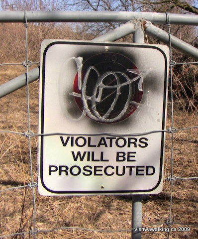
This sign, one of several, warns people to stay off the active railroad tracks that run near the first Trent-Severn lock. You actually have no need to walk on these tracks to get through the area. Photo: March 20, 2009.
Vishwawalking
Lower Trent Trail
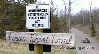
Trenton to Glen Ross, Central Ontario
Total length: 22.4 kilometres
When I first walked this trail, agroup calling themselves Friends of the Trail Inc. were working to organize this trail. They wanted to see the former rail bed turned into a walking, biking and skiing trail, with no motorized vehicles allowed. The Friends became a group in 2004 and were still functioning in 2009, but seem to have disintegrated since then. In 2021, I could not track them down.
The trail has been designated as non-motorized since 1998 when it became the responsibility of the Ontario Ministry of Natural Resources. Since that time studies and (according to the Friends) public consultations have confirmed that it is best suited as a walking trail.
At
present, sections from Stockdale Road north of Trenton, to Glen Ross
are already designated. Other sections on private land, have a way to
go before the trail will be continuous.
I
walked the trail from Trento to Glen Ross in March, 2009 and haven't
been back, so take some of the following with a grain of salt. When the
trail is not official, you must (as I did) use youir ingenuity. It
seems that no progress has been made on some sections, so the urban
buishwhacking I did still needs to be done some Googling I did in
2021 seems to indicate there are still private land issues. You
have been warned: now let the adventure begin!
According
to a person I talked to in Trenton's Chamber of Commerce, in the summer
of 2009, students will be putting up signs on the trail. At present,
the rail be is there, but there is no signage as of March, 2009.
The Friends originally wanted the trail to extend right to downtown Trenton and connect with the Lake Ontario Waterfront Trail. Fantastic. I took that as my personal walking objective too. It's not without serious problems. My walk to Stockdale Road is a mix of already established paths, active rail bed and private property.
Have a look at my rails to trails page if you want more information and links to railway history and the like.
Forgive me if I stress this several times throughout: not all of these sections are recommended walks, as parts travel over potentially dangerous areas. It is, rather, a hope that trail organizers can deal with these very real issues and get a trail up and running.
I started on the west side of the canal, by the main bridge into town, at Dundas and Front streets and moved north along the river. The municipality has done well here, with a nice stone path running past what was once the back end of restaurants but now look very attractive. Past this at the end of the first parking lot is the Chamber of Commerce where you can get some good and friendly information on trails in the area.
The city has worked hard to recapture the waterfront along the west shores of the Trent, making the walk up the green belt just east of Front Street a study in contrasts. Look east and you'll see grass, a few trees and shrubs and the Trent River. Not hard on the eyes at all. Look left and you'll see the businesses of Front Street which are something less than picturesque.
Just after the Dixon Drive bridge, you can see the cement piles from a now defunct rail bridge. At this spot, there is a little "shrine" to a young boy. An angel playing a harp sits on top of a little stone that reads "In loving memory of Larry Hare, September 19, 1991 - November 4, 2001." Plastic flowers adorn the fence behind.
A bit farther along, there are a few houses on the waterfront here, some with fine decks and backyards that look out onto the river. The houses face directly onto Front Street, very close to the road. Again a pretty sad front view and a pretty decent back view.
Shortly after you pass under the (active) railway, you have a choice: you can cut west across the road to (say) Radeski or Allore streets, which will jog you over to the continuation of Front Street (the Front Street you were following turns into Water Street). Scraps of the abandoned line appear not long after, but you'll have to stick to Front Street to get you over Mayhew Creek. Once you lock onto the track bed at Davis Street, you can follow it up and under the Viarail line (the station will be on your right) and into Tri-County Agromart Limited.
A better but longer way is to continue along the river, crossing a little bridge that takes you over a little stretch of water to the Jack Lange Memorial Walkway. This is a pleasant 1.3 kilometre path. Across the river is the Norampac factory, once related to Domtar. The factory once produced (and may still produce) dombind, a oily liquid substance that was once put on roads to keep the dust down. It also contained dioxins, so after much public pressure the practice was stopped. The mouth of the Trent River is clogged with dioxins and furans, at present sitting quietly on the river bed waiting for someone or something to stir it up. Despite their environmental transgressions, Domtar and Norampac are masters at aggressively pursuing anyone who maligns them; libel chill is alive and well.
 These are the thoughts that I turned over in
my mind as I walked the Jack Lange Memorial Walkway on a
sunny
March day. Trenton is a strange city: grubby with industry, but with
beautiful little pathways interlacing bits of it. I hope the
municipality's push to develop trails will improve its reputation.
These are the thoughts that I turned over in
my mind as I walked the Jack Lange Memorial Walkway on a
sunny
March day. Trenton is a strange city: grubby with industry, but with
beautiful little pathways interlacing bits of it. I hope the
municipality's push to develop trails will improve its reputation.
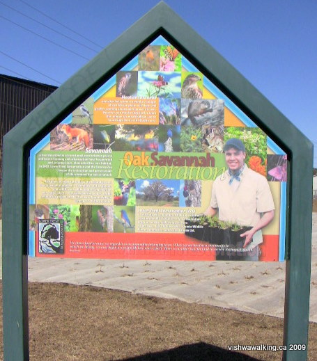
There are concentrated municipal efforts to improve the environment here. The Lower Trent Conservation Authority, with partners, is undertaking an "Oak Savannah Restoration," planting native shrubs and trees in an area that has been ravaged by farming operations. In this area, bur oak is being encouraged.
As the sign notes, savannah is usually connected to areas in Africa, but there is an attempt to return the land to the semi-open grasslands that where originally there.
Sign on the Jack Lange Memorial Walkway, Trenton,
describing the Oak Savannah Restoration
March 20, 2009
Bur oak can grow very large. It's a slow grower, but apparently faster than some oaks. Behind the sign announcing the restoration is a burlap-like cloth laid out on the ground with plants growing through it. I'll visit this area in 20 years and give an update.
The Jack Lange Memorial Walkway ends at the Viarail tracks by the first lock on the Trent-Severn. There is a dire sign here on the tracks advising you that the police will prosecute trespassers.
You have no need to go near the tracks.You can cut left over a fence and along the edge of the warehouses/factories, or use the cart track to the south of the tracks. My topo lists the track as a sidetrack, but none exists now. The cart track ends at a fence that again advises you not to enter. From here you can follow along the back of the industrial buildings, past old vehicles and tires, across Trenton Street, under the tracks and onto County Road 33. The Viarail station will be up the hill on your right. Cross #33 and head up the Tri-County Agromart driveway, toward the silos. You may see train cars to your left. That's where you're heading.
These are active cars, so this part of the trail is just a hope that trail developers can work out something that will allow safe passage. For now, it's not recommended.
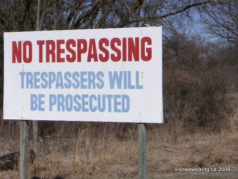
Once past the silos, the tracks pass under Highway #401 and come to an end. There is then a gate with a "No Trespassing" sign on it, followed by a large parking area for trucks, behind a big factory. Once through the lot, there's a similar gate on the farther side with a similar sign. The trail continues from here. About 660 metres from the gate, is Stockdale Road.
Now, one final time, here's the dilemma. As you reach Stockdale Road, you'll see a house to your left and you have to walk over a piece of the owner's driveway to get to the road. I spoke at length with the friendly owners (a man and woman) of the house and the bit of driveway. He was very reasonable. They had nothing good to say about ATV and snowmobile users who tore up the road. He also said bus loads of people came, walked south to the first gate, ate lunch and left a mess. He had no problem with casual walkers, although he said the police clamped down on people using the Highway #401 underpass I had just used. People on motorcycles were the main problem, he said. He also said people parked their snowmobile/ATV trailers blocking his drive, near where I was parked.
While we talked the woman picked a huge handful of garbage from her ditch: McDonald's packaging, cups from Tim Hortons, you name it. She said she'd picked up garbage not long ago, but it's a steady stream.
So it's a problem. I hope that gates, fences, stiles and active volunteers will be beneficial to owners like this who have a legitimate gripe, but whose aid is needed if this trail is to get off the ground.
Rating: Difficulty: moderate.
Running Total: 8.4
It is difficult to find a public place to park at Stockdale Road. Hopefully, a little parking area can be built in the future.
From this point the trail loses the city. At the 610-metre point, the trail crosses Lock Road and then it's straight through to McCaulay.
As with most track beds it's nasty straight. However, because it is so narrow, with tree branches often stretching into the trail, it holds interest. The beauty of this trail is its narrowness; it's different from the wide and road-like "multi-use" trails.
I passed some grazing horses in a field, before moving on to scrubby forest and marshland. At one point some poplars had toppled from the wet marsh onto the trail, but someone had chopped the branches away, leaving a very nice archway to walk under. I disturbed my first garter snake of the season, sunning itself in the middle of the track and not too pleased when I hung around to photograph him.
At around the 2.8 kilometre point, you'll see a path going sharply up the hill to the left. This is the trail to the Bleasdell Boulder. This is a must-see sidetrip. You can drive in and walk about 625 metres to the huge boulder, but you can take a more fun 450 metre walk from the trail to see. it. However, while you're at it take a tour of the entire 1.8 kilometres of trails, they're varied, and well laid out. Don't miss the ridge walk, just after the bridge on the north side of the loop.
 Roughly
65 metres from the Bleasdell Boulder path is a
little bridge over a stream. (It's the only bridge along this section,
so if you reach it without seeing the Bleasdell Boulder path, you'll
know you've overshot it.) The trail has a long gentle curve here that's
a nice break, before you reach Bernard Long Road (noted as McCauley
Road on some maps, but signed as Bernard Long Road). There's a fence
blocking
the trail here and a massive sign just to the south saying "no
trespassing." It looks like machines may have passed over someone's
lawn. A truck nearby sat with its engine idling
as I poked about taking pictures.
Roughly
65 metres from the Bleasdell Boulder path is a
little bridge over a stream. (It's the only bridge along this section,
so if you reach it without seeing the Bleasdell Boulder path, you'll
know you've overshot it.) The trail has a long gentle curve here that's
a nice break, before you reach Bernard Long Road (noted as McCauley
Road on some maps, but signed as Bernard Long Road). There's a fence
blocking
the trail here and a massive sign just to the south saying "no
trespassing." It looks like machines may have passed over someone's
lawn. A truck nearby sat with its engine idling
as I poked about taking pictures.
Rating: Easy
Home
| Contact Us
| Site
Map The Friends originally wanted the trail to extend right to downtown Trenton and connect with the Lake Ontario Waterfront Trail. Fantastic. I took that as my personal walking objective too. It's not without serious problems. My walk to Stockdale Road is a mix of already established paths, active rail bed and private property.
Have a look at my rails to trails page if you want more information and links to railway history and the like.
Downtown Trenton to Stockdale Road
Total: 5.2 kilometresForgive me if I stress this several times throughout: not all of these sections are recommended walks, as parts travel over potentially dangerous areas. It is, rather, a hope that trail organizers can deal with these very real issues and get a trail up and running.
I started on the west side of the canal, by the main bridge into town, at Dundas and Front streets and moved north along the river. The municipality has done well here, with a nice stone path running past what was once the back end of restaurants but now look very attractive. Past this at the end of the first parking lot is the Chamber of Commerce where you can get some good and friendly information on trails in the area.
The city has worked hard to recapture the waterfront along the west shores of the Trent, making the walk up the green belt just east of Front Street a study in contrasts. Look east and you'll see grass, a few trees and shrubs and the Trent River. Not hard on the eyes at all. Look left and you'll see the businesses of Front Street which are something less than picturesque.
Just after the Dixon Drive bridge, you can see the cement piles from a now defunct rail bridge. At this spot, there is a little "shrine" to a young boy. An angel playing a harp sits on top of a little stone that reads "In loving memory of Larry Hare, September 19, 1991 - November 4, 2001." Plastic flowers adorn the fence behind.
A bit farther along, there are a few houses on the waterfront here, some with fine decks and backyards that look out onto the river. The houses face directly onto Front Street, very close to the road. Again a pretty sad front view and a pretty decent back view.
Shortly after you pass under the (active) railway, you have a choice: you can cut west across the road to (say) Radeski or Allore streets, which will jog you over to the continuation of Front Street (the Front Street you were following turns into Water Street). Scraps of the abandoned line appear not long after, but you'll have to stick to Front Street to get you over Mayhew Creek. Once you lock onto the track bed at Davis Street, you can follow it up and under the Viarail line (the station will be on your right) and into Tri-County Agromart Limited.
A better but longer way is to continue along the river, crossing a little bridge that takes you over a little stretch of water to the Jack Lange Memorial Walkway. This is a pleasant 1.3 kilometre path. Across the river is the Norampac factory, once related to Domtar. The factory once produced (and may still produce) dombind, a oily liquid substance that was once put on roads to keep the dust down. It also contained dioxins, so after much public pressure the practice was stopped. The mouth of the Trent River is clogged with dioxins and furans, at present sitting quietly on the river bed waiting for someone or something to stir it up. Despite their environmental transgressions, Domtar and Norampac are masters at aggressively pursuing anyone who maligns them; libel chill is alive and well.
These are the thoughts that I turned over in
my mind as I walked the Jack Lange Memorial Walkway on a
sunny
March day. Trenton is a strange city: grubby with industry, but with
beautiful little pathways interlacing bits of it. I hope the
municipality's push to develop trails will improve its reputation.There are concentrated municipal efforts to improve the environment here. The Lower Trent Conservation Authority, with partners, is undertaking an "Oak Savannah Restoration," planting native shrubs and trees in an area that has been ravaged by farming operations. In this area, bur oak is being encouraged.
As the sign notes, savannah is usually connected to areas in Africa, but there is an attempt to return the land to the semi-open grasslands that where originally there.
Sign on the Jack Lange Memorial Walkway, Trenton,
describing the Oak Savannah Restoration
March 20, 2009
Bur oak can grow very large. It's a slow grower, but apparently faster than some oaks. Behind the sign announcing the restoration is a burlap-like cloth laid out on the ground with plants growing through it. I'll visit this area in 20 years and give an update.
The Jack Lange Memorial Walkway ends at the Viarail tracks by the first lock on the Trent-Severn. There is a dire sign here on the tracks advising you that the police will prosecute trespassers.
You have no need to go near the tracks.You can cut left over a fence and along the edge of the warehouses/factories, or use the cart track to the south of the tracks. My topo lists the track as a sidetrack, but none exists now. The cart track ends at a fence that again advises you not to enter. From here you can follow along the back of the industrial buildings, past old vehicles and tires, across Trenton Street, under the tracks and onto County Road 33. The Viarail station will be up the hill on your right. Cross #33 and head up the Tri-County Agromart driveway, toward the silos. You may see train cars to your left. That's where you're heading.
These are active cars, so this part of the trail is just a hope that trail developers can work out something that will allow safe passage. For now, it's not recommended.
Once past the silos, the tracks pass under Highway #401 and come to an end. There is then a gate with a "No Trespassing" sign on it, followed by a large parking area for trucks, behind a big factory. Once through the lot, there's a similar gate on the farther side with a similar sign. The trail continues from here. About 660 metres from the gate, is Stockdale Road.
Now, one final time, here's the dilemma. As you reach Stockdale Road, you'll see a house to your left and you have to walk over a piece of the owner's driveway to get to the road. I spoke at length with the friendly owners (a man and woman) of the house and the bit of driveway. He was very reasonable. They had nothing good to say about ATV and snowmobile users who tore up the road. He also said bus loads of people came, walked south to the first gate, ate lunch and left a mess. He had no problem with casual walkers, although he said the police clamped down on people using the Highway #401 underpass I had just used. People on motorcycles were the main problem, he said. He also said people parked their snowmobile/ATV trailers blocking his drive, near where I was parked.
While we talked the woman picked a huge handful of garbage from her ditch: McDonald's packaging, cups from Tim Hortons, you name it. She said she'd picked up garbage not long ago, but it's a steady stream.
So it's a problem. I hope that gates, fences, stiles and active volunteers will be beneficial to owners like this who have a legitimate gripe, but whose aid is needed if this trail is to get off the ground.
Rating:
Difficulty: moderate.Walked:
March 20, 2009
2) Stockdale Road to Bernard Long Road
Total: 3.2Running Total: 8.4
It is difficult to find a public place to park at Stockdale Road. Hopefully, a little parking area can be built in the future.
From this point the trail loses the city. At the 610-metre point, the trail crosses Lock Road and then it's straight through to McCaulay.
As with most track beds it's nasty straight. However, because it is so narrow, with tree branches often stretching into the trail, it holds interest. The beauty of this trail is its narrowness; it's different from the wide and road-like "multi-use" trails.
I passed some grazing horses in a field, before moving on to scrubby forest and marshland. At one point some poplars had toppled from the wet marsh onto the trail, but someone had chopped the branches away, leaving a very nice archway to walk under. I disturbed my first garter snake of the season, sunning itself in the middle of the track and not too pleased when I hung around to photograph him.
At around the 2.8 kilometre point, you'll see a path going sharply up the hill to the left. This is the trail to the Bleasdell Boulder. This is a must-see sidetrip. You can drive in and walk about 625 metres to the huge boulder, but you can take a more fun 450 metre walk from the trail to see. it. However, while you're at it take a tour of the entire 1.8 kilometres of trails, they're varied, and well laid out. Don't miss the ridge walk, just after the bridge on the north side of the loop.
Roughly
65 metres from the Bleasdell Boulder path is a
little bridge over a stream. (It's the only bridge along this section,
so if you reach it without seeing the Bleasdell Boulder path, you'll
know you've overshot it.) The trail has a long gentle curve here that's
a nice break, before you reach Bernard Long Road (noted as McCauley
Road on some maps, but signed as Bernard Long Road). There's a fence
blocking
the trail here and a massive sign just to the south saying "no
trespassing." It looks like machines may have passed over someone's
lawn. A truck nearby sat with its engine idling
as I poked about taking pictures. Rating:
EasyWalked:
March 20, 2009
Running Total: 13.7
Along with the big "No trespassing" sign, there are lots of red dots warning people away from this area, but none directly on the link fence across the trail. You can walk around the left side of the fence and you're back on the trail.
Enjoy the upcoming curve. It's the last you'll get for a long time. On the right (east) side of the curve, you'll pass a truck yard and then an area with masses of cardboard packed into piles and strung together. They've obviously been there quite a while as they look pretty weathered. Then the curve straightens out and rows of cedars line the trail.
The cedars do make fascinating walking. It's like getting drawn into a long tunnel, with cedars trailing off into the distance. Off to your right, there's a constant noise from traffic on the Trenton-Frankford Road (County Road #33), which runs parallel to the trail.
The first kilometre (roughly) was shown in 2009 on an old Friends of the Trail map as being private. I'm not sure if it still is.
In a kilometre, you'll pass under some hydro wires. If parking anywhere near Bernard Long Road intimidates you, here's a good place to hook into the trail. There's a parking lot between the Trenton-Frankford Road and the Trent River. It's just a short walk in to the trail with no fence climbing.
You pass Plant Street then the road into the old Bata plant, which now houses municipal buildings. The Bata plant is getting a little rough around the edges, but some of the nearby buildings are looking healthier, including the fire department buildings and a community hall.
The Bata Shoe Company has had an interesting history. (Be wary of the Wikipedia page I have linked to. It gives some good history, but its positive tone evades an adequate discussion of the controversies the family has had.)
The Bata family are originally from Czechoslovakia and run one of the largest shoe companies in the world. Thomas Bata, the founder, had some interesting ideas about how to build healthy communities and make shoes at the same time. His descendants had fascinating international adventures. Thomas's brother was accused of colluding with the Nazis, but the family has vehemently denied this and as late as 2007, proceedings in Prague were undertaken to clear his name. The family says the accusations were a ploy to allow the communists to take over the company. However, Thomas's brother was chased out of the United States after being accused of dealing with the Axis. Supporters of the family say he helped Jews avoid Nazi persecution.
"Market evolution" (gotta love that euphemism!) led to the closing of the plant in Batawa in 1999. In short, workers were cheaper in developing countries. Like Thomas, his descendants liked community, but not when it affected the bottom line. Still, locals seem to like the family. You see their name around a lot, despite the fact that the family cleared out some time ago. Sonja Bata, wife of Thomas Bata junior, purchased land from the Bata company and wanted to start some community projects sometime in the early 2000s. So far, it doesn't look like much has been done.
The Bata Shoe Museum in Toronto may be worth a visit. I've never been there.
As you walk north of Bata Road with the old plant on your left, notice the osprey nest on top of a hydro pole. The birds have had a convenient platform built for them. The osprey themselves were gliding back and forth, but disappeared when I took too long to try to photo them, so I left them in peace.
Shortly after the Bata plant, the cedars finally give way and a number of workplaces appear signalling the start of an industrial park. From what I can read from a couple of online maps, the park will expand if it gets any takers, with some property booked up just off the trail. These are not pretty sights here, and sometimes the industry has contributed to the garbage along the trail. Speaking of this, the garbage is not huge, but discarded tires, barrels, old bottles and the like are spread along the trail.
After you pass the backside of the industrial park, the backyards of Frankford residences start to appear. On the day I walked, a huge dog leaped toward me at the start of this section, scaring the hell out of me. Luckily it was on a chain. Its owner in the nearby house hastily shut an open window to inoculate herself from any responsibility.
Further on, smaller dogs tried to replicate my first experience, but the big shock was over, so I enjoyed the yapping of the keepers of the backyards of Frankford. After you cross March Street, the trail spruces up. It's very pleasant here, with a fine bridge crossing Cold Creek, which is on its way east to its mouth not far off at the Trent River.
After the bridge, the north-south Park Street angles into the trail; a good place to park a car if you wanted to start from this section. Then it's Wallace Street, Bruce Street, and finally Mill Street, the main cross street in Frankford. A stroll into town could be fun. There are a couple of restaurants and a grocery store you can check out. Have a look at the residential sections. You've already seen the back yards; now check out the front yards. It's a fine example of a small Ontario town.
Rating: Easy.
Running total: 22.4 kilometres (This is the total length of the trail)
The trail continues behind backyards on the right and a wood on the left sloping upward. On the day I travelled this section (April 23, 2009), two workers and a tractor were levelling the surface of the trail.
The trail crosses Adelaide Street, then angles across Scott and crosses Concession Road before settling down to more rural surroundings. New houses on the outskirts of town perch at the top of the hill on the left, with very steep lawns stretching down to the trail. Several have large decks and you can see why: use of such steep lawns would be pretty restrictive.
The trail crosses Huffman's Road (or Huffman Road, maps differ), then angles across the busy Glen Ross Road. The latter starts out of Frankford as Trent Street North and changes just before the trail crosses it.
After the Glen Ross Road crossing, a huge messy area to your right will appear, like dozens of badly-made beaver houses. A huge pile of rocks introduces this area.
After Sill Island, the Trent River is tantalizingly close. However, private property makes it difficult to get close to the water. No trespassing signs abound. When the trail was about parallel with Heagles Island (a pretty pathetic island at this time of year, awash in water), I walked down a laneway to have a look at the river. I disturbed a beaver by a cottage at the waterfront, who obviously hadn't read the signs.
Outside of Frankford, the trail surface is a bit rutted and made up of large gravel stones and dirt, not at all difficult to walk on. It doesn't change until the trail reaches where Hearn's Road and Prior Lane meet. At this point, the surface changes to a fine gravel, which makes both walking and biking very easy. It remains this way until roughly the point the trail crosses Wild Turkey Lane (about parallel with Heagles Island, if you can see it through the trees). The trail rides high here, with the cottage road below to your right.
The trail crosses Howes Road where it meets Trentside Lane, which heads off to the south. Shortly after this, the trail, after passing over Howes Road once more, crosses more open land, with fields on the left and scrubby trees on the right. As the trail arcs around to the left it gets more interesting, more like a farmer's grassy road. A small ridge brings the trail back into a wooded section. I walked it before the trees had leaves on them, but I'm sure this would make a fine summer walk.
As the arc ends, the trail crosses Glen Ross Road and travels through woods on the left, paralleling the road on the right. As the trail gets close to Glen Ross, notice the huge eroded hill on the left, made up of sandy earth.
A yellow sign signals the river and the end of the trail. However, I'll carry on through to connect with the Hastings Heritage Trail.
The bridge over the Trent River has no sides and only trestles to walk on, so take care. The river was flowing pretty swiftly when I did my spring walk. The centre of the bridge gives you a great view of the dam to the west and the river to the right.
On the north side of the river you'll run into Black Smith Lane. In front of you will be the old railroad swing bridge. A tour onto its trestles is a must. You'll have to do a bit of climbing to get onto the bridge which will allow you a good look down onto the canal. When you've had your fill of that, head back to the road and east to Glen Ross Road. There's a little store on the right-hand side where you can buy a few basics.
Cross the bridge over the canal to Pioneer Lane. There's a parking lot on your left. The Hastings Heritage Trail starts here. It runs close to the north side of the canal before heading right (north) up a small incline. Remember, this is ATV country. You are no longer safe...
As the Lower Trent Trail people write on their website: " Dirt bikes, ATV’s, snowmobiles and other off-road vehicles are sources of air, water and noise pollution. Numerous articles both in Canada and the United States describe high pollution indicators associated with off-road vehicles. In addition to noise and air pollution, off-road vehicles are known to compact the soil, cause soil erosion, destroy delicate vegetation and contaminate creeks and streams."
Amen, brother.
Rating: Easy.
3) Bernard Long Road to Mill Street (Frankford)
Total: 5.3Running Total: 13.7
Along with the big "No trespassing" sign, there are lots of red dots warning people away from this area, but none directly on the link fence across the trail. You can walk around the left side of the fence and you're back on the trail.
Enjoy the upcoming curve. It's the last you'll get for a long time. On the right (east) side of the curve, you'll pass a truck yard and then an area with masses of cardboard packed into piles and strung together. They've obviously been there quite a while as they look pretty weathered. Then the curve straightens out and rows of cedars line the trail.
The cedars do make fascinating walking. It's like getting drawn into a long tunnel, with cedars trailing off into the distance. Off to your right, there's a constant noise from traffic on the Trenton-Frankford Road (County Road #33), which runs parallel to the trail.
The first kilometre (roughly) was shown in 2009 on an old Friends of the Trail map as being private. I'm not sure if it still is.
In a kilometre, you'll pass under some hydro wires. If parking anywhere near Bernard Long Road intimidates you, here's a good place to hook into the trail. There's a parking lot between the Trenton-Frankford Road and the Trent River. It's just a short walk in to the trail with no fence climbing.
You pass Plant Street then the road into the old Bata plant, which now houses municipal buildings. The Bata plant is getting a little rough around the edges, but some of the nearby buildings are looking healthier, including the fire department buildings and a community hall.
The Bata Shoe Company has had an interesting history. (Be wary of the Wikipedia page I have linked to. It gives some good history, but its positive tone evades an adequate discussion of the controversies the family has had.)
The Bata family are originally from Czechoslovakia and run one of the largest shoe companies in the world. Thomas Bata, the founder, had some interesting ideas about how to build healthy communities and make shoes at the same time. His descendants had fascinating international adventures. Thomas's brother was accused of colluding with the Nazis, but the family has vehemently denied this and as late as 2007, proceedings in Prague were undertaken to clear his name. The family says the accusations were a ploy to allow the communists to take over the company. However, Thomas's brother was chased out of the United States after being accused of dealing with the Axis. Supporters of the family say he helped Jews avoid Nazi persecution.
"Market evolution" (gotta love that euphemism!) led to the closing of the plant in Batawa in 1999. In short, workers were cheaper in developing countries. Like Thomas, his descendants liked community, but not when it affected the bottom line. Still, locals seem to like the family. You see their name around a lot, despite the fact that the family cleared out some time ago. Sonja Bata, wife of Thomas Bata junior, purchased land from the Bata company and wanted to start some community projects sometime in the early 2000s. So far, it doesn't look like much has been done.
The Bata Shoe Museum in Toronto may be worth a visit. I've never been there.
As you walk north of Bata Road with the old plant on your left, notice the osprey nest on top of a hydro pole. The birds have had a convenient platform built for them. The osprey themselves were gliding back and forth, but disappeared when I took too long to try to photo them, so I left them in peace.
Shortly after the Bata plant, the cedars finally give way and a number of workplaces appear signalling the start of an industrial park. From what I can read from a couple of online maps, the park will expand if it gets any takers, with some property booked up just off the trail. These are not pretty sights here, and sometimes the industry has contributed to the garbage along the trail. Speaking of this, the garbage is not huge, but discarded tires, barrels, old bottles and the like are spread along the trail.
After you pass the backside of the industrial park, the backyards of Frankford residences start to appear. On the day I walked, a huge dog leaped toward me at the start of this section, scaring the hell out of me. Luckily it was on a chain. Its owner in the nearby house hastily shut an open window to inoculate herself from any responsibility.
Further on, smaller dogs tried to replicate my first experience, but the big shock was over, so I enjoyed the yapping of the keepers of the backyards of Frankford. After you cross March Street, the trail spruces up. It's very pleasant here, with a fine bridge crossing Cold Creek, which is on its way east to its mouth not far off at the Trent River.
After the bridge, the north-south Park Street angles into the trail; a good place to park a car if you wanted to start from this section. Then it's Wallace Street, Bruce Street, and finally Mill Street, the main cross street in Frankford. A stroll into town could be fun. There are a couple of restaurants and a grocery store you can check out. Have a look at the residential sections. You've already seen the back yards; now check out the front yards. It's a fine example of a small Ontario town.
Rating:
Easy.Walked:
April 21, 2009
FrankfordIt's worth strolling through Frankford. There are a couple of nice churches, some interesting old homes and the Trent River/canal.Frankford Tourist Park is located on the east bank just south of the main bridge. You can get to it by heading onto the bridge and taking the road south into the park.You can also get to the park from Riverside Parkway, which runs south from County Road #5 (the road with the bridge), down the east side of the canal and the river. There's a little parking lot about 650 metres south of County Road #5. The Quinte west municipal site says the park has "trails." Not really. The stroll through the parks to the locks is easy and relaxing. The entire loop is about 1.2 kilometres. The park has camping facilities with electricity and running water. There's a children's playground by the parking lot and a big roofed eating area with lots of picnic tables. The municipality does not advertise the rates, etc. on signs in the park or on its website. 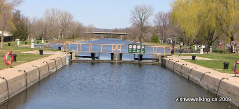 Trent Canal, Lock #6, Frankford, looking north to County Road #5/Mill Street. The park is on the left. On the north side of County Road 2 have a look at the dams. If you walk, its about 850 metres from the north parking lot south of the bridge to the dam. I cheated and drove, as the walk is not very interesting. Before you leave the park, take the road off to the right (north) which will lead you under the bridge and between the canal and the river. There's a swing bridge that isn't used any more sitting at the end of this spit. It's hard to know what its purpose is. There are two interesting boxes at the top and different gears, rails and the like running its length. Worth clambering about on them, but take care. In the spring, the water gushing through the gates of the dam is huge. I crept along the top of the dam in a ridiculously cautious fashion — but, hey, that foaming white water is deadly. I've done enough white water canoeing to know a person wouldn't last a second in it. At the end of the dam, if you clamber over the rail, there's a little path that leads up a narrow spit of land to the north side of the little island. From here, you can look across to Bata/Sills Island (see below for a description of trails there), check out the old abutments in the river, running between the islands, and walk down a concrete wall along the water's edge to have a look at the Sills Power Generating Station (see below for more on this). A chain-link fence keeps you from getting too close. The whole little "trail" looks reasonably well travelled, but is still pretty rough, and you'll have to push by numerous bushes. I spent most of my time bent double following the path and stepping over fallen trees and taking care when the path gets close to the river. Still, worth the trouble if you like that kind of thing. (Stick-to-the-road types should avoid this.) It's about 750 metres round trip from the old swing bridge. Walked:
April 25, 2009
|
4) Frankford (Mill Street) to Glen Ross
Total: 8.7 kilometresRunning total: 22.4 kilometres (This is the total length of the trail)
The trail continues behind backyards on the right and a wood on the left sloping upward. On the day I travelled this section (April 23, 2009), two workers and a tractor were levelling the surface of the trail.
The trail crosses Adelaide Street, then angles across Scott and crosses Concession Road before settling down to more rural surroundings. New houses on the outskirts of town perch at the top of the hill on the left, with very steep lawns stretching down to the trail. Several have large decks and you can see why: use of such steep lawns would be pretty restrictive.
The trail crosses Huffman's Road (or Huffman Road, maps differ), then angles across the busy Glen Ross Road. The latter starts out of Frankford as Trent Street North and changes just before the trail crosses it.
After the Glen Ross Road crossing, a huge messy area to your right will appear, like dozens of badly-made beaver houses. A huge pile of rocks introduces this area.
Bata or Sill IslandTotal: 1.7 kilometresAt the point Glen Ross Road crosses just north of Huffman Road, a dirt road leads by a pile of rocks to a bridge which leads over to Sill Island (also known as Bata Island).A walk around the island is a must. This is one of Frankford's little secrets: a beautiful little island with a few easy trails and some great views of the river. It's a perfect spot for a picnic. 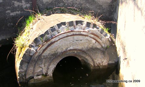 Before
you cross the yellow bridge to the island, take a look at the old
millstones lying near the bridge. One nestles in the water just north
of the bridge and a couple of others are lying on the bank
not
far away. Before
you cross the yellow bridge to the island, take a look at the old
millstones lying near the bridge. One nestles in the water just north
of the bridge and a couple of others are lying on the bank
not
far away.I hope someone saves at least one of these and puts it in a prominent place (on the island, say) before they are ploughed into the earth. These stones were used in pairs to grind grain. Grindstone, near Bata/Sill Island, north of Frankford The concrete stones have an outer band of black flintstone-like material, like concrete wheels with flintstone tires. Metal bolts keep the stones from falling apart. A grist mill was built in Frankford in the 1880s and operated until 1972. One website lists a W.A.R. Milne as the Miller at Sills' grist mill until his early death in 1920. The trails are marred by a few yahoos who have thrown garbage here and there, but it's not overwhelming. On the spring day I walked these trails, I got my first view of wild flowers for the season. In areas, beautiful covers of blue spread through the woods. The trails are easy, and wander to each end of the island. There are a few places where you can stop by the water to picnic. At the north end, there are abutments to an old bridge, where ducks, geese and other birds gather. I saw a white bird with an incredibly long orange beak sitting on one of the abutments. (Damn. I need to study bird species.) The northern loop, at just over 1 kilometre, is the longest round-trip stroll. It has a little 200-metre spur running parallel to the north-east side of the trail. I found this a bit wet on the spring day I walked it. As the northern spur loops back to the bridge, an open area appears; this would make another nice picnic spot. The south trail, about 340 metres, leads to the section of the river that splits Bata/Sill Island from the little island to the south. You can get a good view of the dams to the south from here and the Sills Island Generating Station, (sic: that's how it's listed by Ontario Power generation), which is the second oldest generating station in the province. It was originally used as a paper mill. The G.E. Sills Paper Mill or the above-mentioned grist mill were presumably the origin of the island's name. A little 100-metre spur about 115 metres from the bridge cuts across the island from the south trail to the eastern side. It's not well travelled and I debated as to whether it was an "official" trail. It's best to stick to the trails on the island as you could disturb a lot of flora and fauna tromping through the bush, especially as there are lots of stopping places to picnic. The island is so small that you'll have no trouble spotting wildlife (While updating this information, I ran across a page by "Mike and Lily," on geocaching.com. They had blatantly plagiarized my musings on Sill Island, integrating my writing with their comments. No credit. No respect.) Rating: Easy.Walked:
April 25, 2009
|
After Sill Island, the Trent River is tantalizingly close. However, private property makes it difficult to get close to the water. No trespassing signs abound. When the trail was about parallel with Heagles Island (a pretty pathetic island at this time of year, awash in water), I walked down a laneway to have a look at the river. I disturbed a beaver by a cottage at the waterfront, who obviously hadn't read the signs.
Outside of Frankford, the trail surface is a bit rutted and made up of large gravel stones and dirt, not at all difficult to walk on. It doesn't change until the trail reaches where Hearn's Road and Prior Lane meet. At this point, the surface changes to a fine gravel, which makes both walking and biking very easy. It remains this way until roughly the point the trail crosses Wild Turkey Lane (about parallel with Heagles Island, if you can see it through the trees). The trail rides high here, with the cottage road below to your right.
The trail crosses Howes Road where it meets Trentside Lane, which heads off to the south. Shortly after this, the trail, after passing over Howes Road once more, crosses more open land, with fields on the left and scrubby trees on the right. As the trail arcs around to the left it gets more interesting, more like a farmer's grassy road. A small ridge brings the trail back into a wooded section. I walked it before the trees had leaves on them, but I'm sure this would make a fine summer walk.
As the arc ends, the trail crosses Glen Ross Road and travels through woods on the left, paralleling the road on the right. As the trail gets close to Glen Ross, notice the huge eroded hill on the left, made up of sandy earth.
A yellow sign signals the river and the end of the trail. However, I'll carry on through to connect with the Hastings Heritage Trail.
The bridge over the Trent River has no sides and only trestles to walk on, so take care. The river was flowing pretty swiftly when I did my spring walk. The centre of the bridge gives you a great view of the dam to the west and the river to the right.
On the north side of the river you'll run into Black Smith Lane. In front of you will be the old railroad swing bridge. A tour onto its trestles is a must. You'll have to do a bit of climbing to get onto the bridge which will allow you a good look down onto the canal. When you've had your fill of that, head back to the road and east to Glen Ross Road. There's a little store on the right-hand side where you can buy a few basics.
Cross the bridge over the canal to Pioneer Lane. There's a parking lot on your left. The Hastings Heritage Trail starts here. It runs close to the north side of the canal before heading right (north) up a small incline. Remember, this is ATV country. You are no longer safe...
As the Lower Trent Trail people write on their website: " Dirt bikes, ATV’s, snowmobiles and other off-road vehicles are sources of air, water and noise pollution. Numerous articles both in Canada and the United States describe high pollution indicators associated with off-road vehicles. In addition to noise and air pollution, off-road vehicles are known to compact the soil, cause soil erosion, destroy delicate vegetation and contaminate creeks and streams."
Amen, brother.
Rating:
Easy.
Walked:
April 23, 2009
Page
created: March 20, 2009
Updated; March 15, 2021
Updated; March 15, 2021