About Us
Vishwawalking explained
 Ratings Explained
Vishwawalks
Day walks
Funky Places
Future walks
Food
Gear
Get Lost
Good reads
Links
Right to Ramble
Site map
Contact us
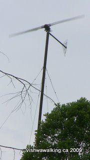
A windmill at the start of the trail. The photo has caught the two blades whirring furiously, but it actually looked quite different. On the day I photographed it, the breeze was up and it looked like there were four or six blades.
Vishwawalking
Trail of Two Lakes/
(Belleville and North Hastings Line)
Introduction
The trail described below is longer than the official trail, which ends at Old Marmora Road, at the southwest end of Madoc.I have described the old Grand Trunk Railroad from Belleville to Madoc Junction on a separate page. At Madoc Junction the Grand Trunk branches westward from the Belleville and North Hastings Railway Company line (the Trail of Two Lakes), to join with the Hastings Heritage Trail and the Trans Canada Trail.
Here I have described old Belleville and North Hastings Railway Company's rail bed from Madoc Junction west of Highway #62 and north of Tuftsville Road to just west of Eldorado (on Highway #62), where it connects with the Hastings Heritage Trail. That is far more than the online listings, which give its length as either 21 or 22 kilometres.
There are sections of this trail north of Madoc that are now disused and have signs indicating they are closed. I'll note these sections clearly. Also, north of Highway #7, traversing this trail is difficult: the walker has vines, thorns, scrub bush and marsh to deal with. Please read these sections very carefully before setting out.
From the pages of the Ontario Railway History site, (which as of June, 2009 can no longer be found on the Internet):
"The Belleville & North Hastings Railway Company (B&NHR) for the most part was a subsidiary of the Grand Junction Railway. Incorporated in 1874, the narrow gauge line extended for a distance of 15 miles (25 km) north from Madoc Junction on the GJR to Eldorado [n.b: the distance is wrong; see my calculations in my walks belowwhich put it in excess of 30 kilometres] to exploit iron ore deposits in the area. Construction was begun in 1878 by Francis Shanly with the line completed and open for traffic by January 1880. It was absorbed by the Grand Junction in July of that year and passed into the hands of the Midland with that company in 1881."
Check out my page on rails to trails for more historical information on railway lines.
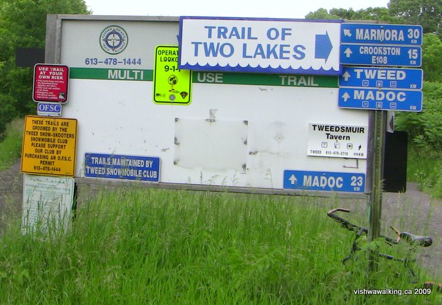
The sign at the junction of the old Grand Junction Railroad and the Belleville and North Hastings Railroad lines (the Trail of Two Lakes). This is kilometre zero for the Trail of Two Lakes. That's my bike at the lower left. if I don't want to walk a round trip, I sometimes drop my bike off at one end or the other for the return journey. This only works on trails that are amenable to bikes. This trail is a bit sandy in parts but still a good bike ride.
1) Start: North of Tuftsville Road to Hollowview Road
Total: 8 kilometresRunning total: 8 kilometres
It's difficult to connect this civilized section of the trail with the wild jungle that ends it near Eldorado. The track branches off the Grand Junction Railway bed just over 200 metres north of Tuftsville Road.
It's easy walking on a cinder and dirt surface. The ATVs have created ruts and pot holes in places, but it is still pretty good for both walking and biking.
The wind was blowing fairly steadily on the day I walked this section and I heard a strong whirring sound as if a motor was running. If you look to your left (west) immediately after the junction, you'll notice a double-armed windmill poking above the trees. It was whirring in good style as I passed.
The trail winds through forest and treed marshy areas, but the fields are never far behind them. at times a farmer's track crossing the trail appears and fields border the trail briefly. The trail rides high through wooded areas and there is no sign of any flooding.
As you near Highway #62, you'll pass under some power lines and notice Rawdon creek on your left (west). As you come to the highway, the woods give way to fields.
Just before the concrete bridge that carries Moira Road over the trail (3.2 kilometres from the start), there's a fine wooden bridge that takes the trail over Rawdon Creek. The creek will be our companion for some time now, winding away from then close to or over the trail all the way to one of its sources, White Lake, which we'll pass by.
After you pass under the bridge, the trail winds slightly in a great little hollow before surfacing into fields with trees lining the trail.
 There
are a couple of open stretches here, with fields on both sides, but
generally, the trail is protected by trees.
There
are a couple of open stretches here, with fields on both sides, but
generally, the trail is protected by trees.A big hunk of metal drainage pipe sticking up at one point — a piece of found art on the trail.
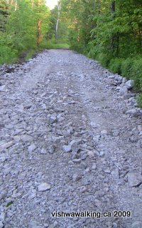
South of Sills Road, there is a short section in which rocks have been used for ballast to fill a dip. It's not pleasant for bike riders.
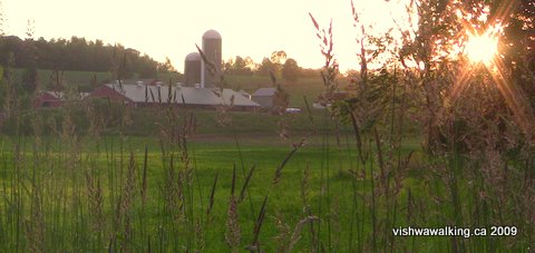
There are several farms across the fields to the west of the trail, just
north of Moira Road.
After Sills Road (2.5 kilometres north of Moira Road), the trail runs in a nice corridor of trees, but despite the feeling of being in the woods (or marsh/woods), the fields are never too far away. Several grassy tracks cross the trail at points. They're marked as roads on my Garmin Mapsource electronic topo. Don't be fooled. They are grassy trails, unfit for road vehicles.
Something short of a kilometre north of Sills Road, there is what looks like an outhouse sitting off the trail to the right, with a big "Private" sign on it. The door is nailed shut. It's well built and fairly recent, and an odd place for a building. A trail runs off behind it to the east, but there are no buildings in the immediate vicinity.
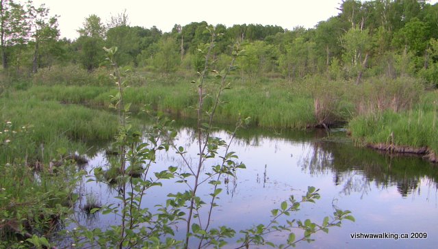
About 900 metres short of Hollowview Road, Rawdon Creek, which has been with us for a while in the form of marsh, joins with one of its many tributaries. Rawdon itself passes from the east side to the west side (or rather comes in from the west, flowing under the trail to follow it south on the east side).
It was early evening when I walked this section, so I passed on the opportunity to look more closely at the creek. However, there was the sound of rushing water on both sides of the trail. A sturdy wooden bridge allows a good view of the creek, but I couldn't see any fast water. it's back there, for the adventurous to discover.
Rating:
Easy. (This section
could easily get a three-walk dude rating were it not for
ATVs.) Walked;
June 17, 19, and 21, 2009
Total 4.2 kilometres2) Hollowview to Ray Road
Running total: 12.2 kilometres
From Hollowview to McCumber Road is 1.4 kilometres of straight trail. The trail crosses Rawdon Creek again about 335 metres north of Hollowview and the creek flows close to the trail for some time now, accompanied by lots of marsh. Fields are visible to the west.
June is turtle-travelling month, from snappers to painted, making their journey across dangerous roads. It's pretty common to stop and help a turtle on its way if it's in the middle of the road, or to stop while someone else does that job. On this section, a hole at the side of the trail, filled with broken turtle eggs, revealed where a family had burst forth to take to the swamp.
A nice opening in the trail, at the point that Rawdon Creek moves close to the trail on the east side. Marsh predominates along this whole section.
 The marsh
continues on both sides of the trail north from McCumber Road. Roughly
half a kilometre
from McCumber, as Rawdon Creek again comes close to the trail on the
east
side, there's a junction between a tributary coming in from the west
and flowing under the trail and the main stream
The marsh
continues on both sides of the trail north from McCumber Road. Roughly
half a kilometre
from McCumber, as Rawdon Creek again comes close to the trail on the
east
side, there's a junction between a tributary coming in from the west
and flowing under the trail and the main streamNear Slab Road, some of the fill to build up low areas uses large and rough rock. This is ATV-friendly, but makes for poor walking and even worse bicycle riding.
As you cross Slab Road, look to your right (east) and you'll see that the road curves around to the north. The road and the trail run parallel for about 500 metres. It's flat and straight, with farmland quickly switching to marshy bush. As we set out a Canada goose honked loudly at us from only 20 or 30 feet away, apparently unconcerned about our presence.
South of Slab Road: Very rough
ATV-friendly rock fill that is not
fun for walkers and bicyclists.
Roughly 1 kilometre
north of Slab Road, Rawdon
Creek passes from west to east under the trail. In the spring,
there's a healthy flow of water on both sides of the trail. A culvert
has been placed under the trail, but it is seriously plugged. The flow
was enough to make us (I walked from Slab Road to this section and back
with my wife, Carol) turn back. I completed the trek to Ray Road the
next day, equipped with water runners to wade through the creek
overflow.
At Ray Road, if you
turn right, you will ascend a hill and reach Douglas Road. Keep walking
straight across the road and you'll enter a trail that leads to
Moreland Lake. It's a nice walk; some sections of that, particularly in
the marshy south part of Moreland Lake are winter walks.
Rating: Easy.
Rating:
Easy.
Walked:
April 9, 10, June 4, 19, 2009
Updated: June 19, 2009
Updated: June 19, 2009
How to get to the beginning of
the trail:
Take Highway #62 north from Belleville (in south-central Ontario). From
Highway #401, drive 14.5 kilometres north until you reach Tuftsville
Road. Turn west on Tuftsville and follow it as it turns north for a
short stretch, then turns sharply west again. After the west turn watch
for the trail crossing as you drive down the hill. The trail crosses
Tuftsville Road 1.5 kilometres from the highway. Walk north on the rail
bed (the old Grand Junction Railroad line) for just over 200 metres,
where you'll see the sign and the junction in the trail. The Trail of
Two Lakes starts on the right (east) side.
Northward: Ray Road to Mill Road
Further still: Mill Road to Hastings Heritage trail just west of Eldorado
Back to main Hastings Heritage Trail page
Back to the top of the
pageFurther still: Mill Road to Hastings Heritage trail just west of Eldorado
Back to main Hastings Heritage Trail page
Home | Contact Us | Site Map
Page created: March 12, 2009
Updated: August 6, 2013