About Us
Vishwawalking explained
 Ratings Explained
Vishwawalks
Day walks
Funky Places
Future walks
Food
Gear
Get Lost
Good reads
Links
Right to Ramble
Site map
Contact us
Vishwawalking
Trail of Two Lakes
Part 3
4) Mill Road to half way to Hemitite Road
Total: 1.5 kilometresRunning Total: 28 kilometres
Warning: Part way to Hemitite Road, the trail fizzles out. I'll figure a way forward, but the rail bed disappears after 1.5 kilometres. On the day I walked this short section, I spent many kilometres wandering through woods and field, delightfully lost, but unable to pick up the trail. I'll tackle it again from the north and see if I can make any connections.
 From
Mill Road, the path is clear and easy, along a farmer's track. It
curves slightly left (west) then straightens out. The rail bed is a
tangled mess of scrub and trees on the left, but the farmer's track is
much more pleasant.
From
Mill Road, the path is clear and easy, along a farmer's track. It
curves slightly left (west) then straightens out. The rail bed is a
tangled mess of scrub and trees on the left, but the farmer's track is
much more pleasant.When the trail curves seriously right (east) after just over half a kilometre, strike off through the grass, sticking with the rail bed, which will become clear as you enter the woods. (If you follow the trail eastward, you'll crest a hill and see a horse farm ahead of you; it's best to steer well clear.)
The rail bed is somewhat overgrown, but walking is initially relatively easy.
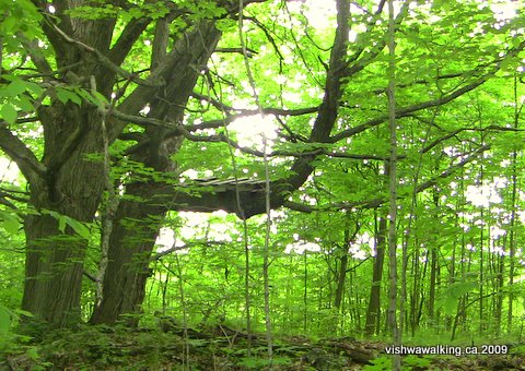
A tree somehow reminding me of
Robin Hood with its platform perch in the
crutch of the branch. Look out for several old growth trees along this section
north of Mill Road when the trail enters the woods.
crutch of the branch. Look out for several old growth trees along this section
north of Mill Road when the trail enters the woods.
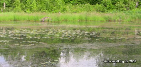 A pond appears on the right, but the
rail bed rides above it.
At one point a little gully briefly cuts across the rail bed, but it is easily picked up if you keep straight ahead, crossing an old cedar rail fence.
From this point it gets progressively rougher. Poison ivy is present, but not overly prolific.
A pond appears to the east of the trail, but the rail bed rides above it. That's a
beaver house in the background.
Brambles slow you down until you reach a marshy spot just before an open field. The marsh (at least in mid-June) is easy to negotiate, but once over an old electric fence and into the field — I lost the trail.
This is what turned a short jaunt into a longer trek. I slogged eastward toward Highway #7, but saw nothing that resembled a rail bed. To the west, in the bush to the northwest, I eventually picked up something that briefly resembled a trail, but its northward track petered out. Southward led me to the back of a barn and house near O'Hara Road, where it joined a farmer's track. There are a number of possibilities here, but nothing I could clearly note as continuance of the trail.
This may be a case of finding as clear a path as possible northward if I can't find the rail bed. The topo (and other maps) I have show some discrepancies here. Some marsh is not noted, some nonexistent roads are marked and the trail is sometimes indicated, but not always in the same place.
It's sad that a railway once existed, but there is now only a fading record of it on the land.
To be continued...
Rating: Unrateable. See below. This is a mild version of what's to come.
Walked:
June 13, 22, 24, 2009

I'm still figuring out the section from the end of the bit I describe above to sections along O'Hara Road. There are no guides. I am using topo maps, the above-mentioned Google Earth (which amazingly shows the outline of the old rail bed) and other aids to find the trial. I am also wandering the countryside getting quite lost trying to figure out where the old track was.
So far, between the south section and the north, I am misssing very roughly 5.5 kilometres that winds back and forth over O'Hara Road. I'm not exacly looking forward to it — the northward bits of the rail bed are very rough — but I'd like to see this project through to the end some time.
July 2013 update: I still haven't returned to complete this. While sections of this trail were beautiful, something still puts me off. Perhaps its the amount of private land (pretty well all of it) that has to be crossed and the tough sections I had to deal with even to get this far. Perhaps the traces of the old railway beds are fated to disappear, another thread that once traced its way across the country lost forever.
O'Hara Road, 680 metres north of Scotch Settlement Road to Hastings Heritage Trail west of Eldorado
Total: 2 kilometres (but it's a long slog through marsh and dense undergrowth)Running total: ?? (Incomplete)
 The
next section, very roughly a short 800-metre stretch until the "trail"
recrosses O'Hara Road 350 metres south of Robinson Road, is something I
am glad I have done — and do not want to revisit.
The
next section, very roughly a short 800-metre stretch until the "trail"
recrosses O'Hara Road 350 metres south of Robinson Road, is something I
am glad I have done — and do not want to revisit.From O'Hara Road, there is a rough pole across an opening that leads to a grassy stretch sloping up a hill to the left.
The rail bed is clear, on the right, curving in the same direction and covered with brush.
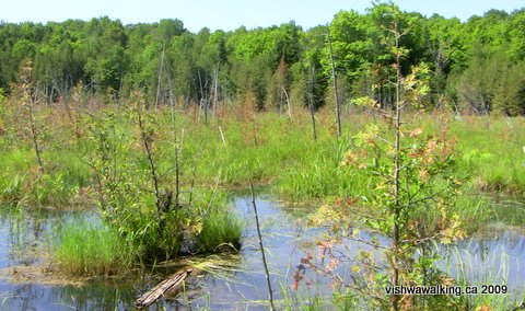
The "problem" looking at the marsh west of O'Hara Road and south of Robinson
Road, from the north to the south. The view is from the north to the south The rail
bed, such as it is, is off to the left. The dead trees in the middle of the swamp
are likely the original bed, but it doesn't really exist at this point. The swamp is
deep at points, and muddy, full of leaches and maybe a snapping turtle or two.
And flies. A wet suit is required. So is a level of insanity.
If you walk along its edge, you will pass a little shed, behind which you will have to move onto the rail bed. The bed then moves out into the swamp. At one point a beaver has built his lodge on the rail bed. Cedar and underbrush make progress slow — and then the raised rail bed disappears.
The first day I attempted this section, I simply followed routine and slipped on my "river runners." With boots slung around my neck, I headed into the water. It soon got deeper, muddier and more complicated. I moved sensitive gear (camera, GPS, wallet) to higher up my body.
Then I hit a hole. As I went down, I twisted back and up to a shaky log. However, one of my walking poles was left stuck in the mud. I spent about 20 minutes sloshing about trying to rescue it to no avail. As I explored, I noticed numerous leaches about, some of them over five inches long. I decided to check my legs.
Freak out time! There were three or four all sucking at one communal spot on my leg and a loner having a go on my calf. I swept them off without much fuss, but I was rattled. The far shore was not possible. I left only halfway through the swamp, without my expedition pole, sloshing through the mud and swatting at the flies. When I got to my car, my trouser leg was soaked with blood — those leaches really suck.
Two days later, I was back — protected by my wet suit. I came in from the north side this time. As I waded south, this time unencumbered by electrical devices, I felt a chomp on my foot, which threw me over backward uttering an appropriate oath at the same time. A snapper?
No damage was done, but I spent the rest of the time prodding with my walking poles to give any snappers advance notice. At times I was chest deep in water and marsh life.
Back at the spot where I lost my pole, I spent the better part of an hour trying to locate it. No luck. I headed back to my car.
The swamp is deeper on the north side, without benefit of the rail bed. At times you'll be walking on sod that is floating on the water.
Once on shore, I found one leach that had broken through my defenses, where my wet suit met my neoprene boots.
On the north side, the rail bed is still not apparent. It probably followed what is now the creek bed that curves northeastward. The bed is very wet and dense with undergrowth, ending with a sharp incline where the rock ballast lines O'Hara Road. At the top of the piles of rock, beside the road, is dense poison ivy. Considering all this, I walked along through a thin line of trees to a field, and turned eastward following the south side of the field to the road. Just after turning north, there's an opening in the hedge where you can get to the road. Watch carefully for poison ivy; it's not bad at the opening, but increases as you head slightly south down the road to line up with the trail.
The trail crosses O'Hara Road at a point 350 metres south of Robinson Road where the road has been built up. Rock-fill is on the west side and a little creek flows under the road. This is the rail bed. Head northwest down into the creek bed and follow it along. You'll cross a farmer's track and then the creek wanders off and the trail gets cluttered with plant life. About 100 metres in (but it seems like more), you'll come across a cedar rail fence. The trail now becomes pleasant — enjoy it, because it won't last. Notice a large barn and outhouses to your left across a field.
A pond will open up to your right and a beaver dam in front of you will allow you to cross in a reasonably dry state. The dam is anchored by a couple of cedar trees and cemented with a lot of mud. it take some gymnastics to negotiate it, but nothing too unreasonable.
After crossing an east-west farmer's track and some rusting garbage — an old truck returning to the earth — you'll cross a little creek. Notice the big flat stones on either side of the track.
It's now easy walking until you come to a barbed-wire fence across the trail. (You'll also see a rudimentary bridge across the creek to your left. It leads to a path that goes up and to the field.) if you walk to the left of the barbed wire, you can step over the adjoining wire fence.
Walking gets tougher here with scrub and thorn bushes slowing you down, but take this as a warm-up for the heavy slogging ahead. You'll cross a fence, and a short distance on you'll negotiate a final fence and a slightly damp ditch to get to the road.
Continue across Rupert Road and into the grassy cut through the hill. The brambles will slow you down first, just before you cross a little stream, where cedars take over. Through all this the trail is clear, but it's slow going.
As the cedars end, you enter marsh hell. The trail remains clear, but it's wet and packed with plant life. I struggled with this one. Usually, by concentrating on the goal, the difficulties of the trail can be exciting.
Not this section. I just wanted out. The mosquitoes were having a party, thunder was rumbling away in the background and the "jungle" was thick! I actually wanted to hear the sound of an ATV, signalling the Hastings Heritage Trail. Now that's desperate.
There are a couple of cedars growing in the trail. The marsh has definitely taken over here, but in mid-June anyway it was still possible to negotiate it in a dry state. The rail bed curves to the right and, after hopping over a little open piece of water, you're on the Hastings Heritage Trail.
From the HHT, it's very difficult to pick out the Trail of Two Lakes. If you want to locate the trail from the HHT, it's 900 metres eastward on the HHT from Highway #62 at Eldorado. A couple of cedars stick up out of the marsh and a curving line indicates the thick growth on the rail bed slightly above the marsh itself.
On the way back, I paused to enjoy a couple of irises in full bloom. It looked like more were either on their way or had recently bloomed.
Then I struck the highlight of the day — an orchid! fantastic. The thunder subsided, the mosquitoes didn't bother and the orchid shone out like a little beacon just above the earth. I hovered respectfully, took lots of pictures stood (there was no place to sit) and contemplated the wonders of life before crashing back through the undergrowth to my car.
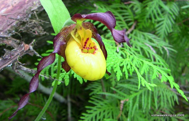
The prize. After a gruelling push over the dense rail bed, I discovered this orchid. Just when I was wondering why I would put myself through such aggressive walking through unfriendly underbrush — this! It was beyond words.
Rating: Unrateable. Some parts are foolish to attempt. Not boring, not bad, very harsh. Then an orchid...
Back to the previous section of this trail
Back to the Trail of Two Lakes Introduction and the first part of the trail
Back to main Hastings Heritage Trail page
Home | Contact Us | Site Map
Page created: March 12, 2009
Updated: July 8, 2013