About Us
Vishwawalking explained
 Ratings Explained
Vishwawalks
Day walks
Funky Places
Future walks
Food
Gear
Get Lost
Good reads
Links
Right to Ramble
Site map
Contact us
White Lake
Madoc
Vishwawalking
Trail of Two Lakes
Part 2
Ray Road To Mill Road2) Ray Road to North Shore Lane
Total: 9 kmRunning total: 21.2
From
Ray Road, the trail heads north in a very slight curve until it passes
under the Trans Canada Trail. It's an impressive crossing here, with
the Trans Canada passing overhead and a curving trail off to the right
up to the higher trail.
A little farther on over the fence on the right (east) side is a tumble-down log cabin. 1.8 km north of Ray Road is County Road 38, known as the Crookston Road.
Just north of Crookston Road, a little wooden bridge crosses Rawdon Creek and a marsh spreads out before you on the left. In March when I walked the trail there's a sense that this was a more active area in times past. The quarry to the left has taken over a bit of the marsh, which runs northward close to the trail, opening up at White Lake. There's lots of ice spilling onto the trail and I'm not sure how passable it would be in warmer spring weather. Someone has chopped all the branches from the trees lining the trail, which gives it a strange symmetry. At less than 2 km from Crookston Road, the trail reaches the lake.
There's a road heading back to highway #62 here. It's likely private. It's a worthwhile taking a short deviation here to the highway where the White Lake Pioneer Cemetery hides in a pine wood beside Highway #62. The cemetery is neglected now, with tumble-down stones. Most of the people here died in the 1800s or early 1900s. The photographs tell the best story.
Continuing north along the west edge of White Lake, you'll shortly come upon a private dock leading to the water. It gives a nice central view of the little lake. A couple of houses will be on your left and you can hear the highway running close by.
It was quite wet the spring day I walked it, with little streams running from the west into the lake and long series of ponds dotting some sections. Fortunately for walkers, there's a thin ridge of higher ground along both sides of the trail most of the time.
Along the north edge of White Lake, large stones have been put into the trail to build it up. The stones would make tough biking and would be no fun for me at least, although I suppose there are some masochist bikers out there who would like it.
I spent some time watching the new life here — little minnows and insects — swimming in the clear ponds on either side of the trail. Ice still lingers in spots. In fact, I tentatively tried a spot of ice on White Lake. On March 27, the ice was still strong enough that I imagine I could still walk to the middle of the lake (although it would be foolish to do so).
As I watched the burgeoning life in a little pond, I heard an ATV approaching relatively slowly through the myriad ponds on the trail. After it past, all the little streams and ponds on the east side were clouded with a gush of trail sand and mud that poured from the trail. The trail edges have also been scarred here with a recent chopping of trees and tree branches. I thought back to my recent walk on the Lower Trent Trail, which does not allow motorized vehicles. Tree branches stretch into the trail on both sides and you have to sometimes duck or push them aside. Here, such a natural setting would impede the speed of vehicles, so it's not tolerated. Pity.
Still, machines aside, this is a fine section of trail. White Lake subsides into marsh on the right, while fields appear on the left. At one point I came upon two deer casually walking toward me on the trail. I stepped off the trail and up a little hill to hide and came upon a whole flock of wild turkeys near a wet spot in a big field. By the time I left them, the deer had disappeared.
On the left side, there are plenty of spots to picnic, under some excellent stands of pine. There's a mix of pine and cedar along the right-hand side. At one point the marsh on the right opens up to a wide expanse; later in the year I imagine it will be a hive of activity for insects, birds, small mammals and aquatic beasts. I imagine Snake Lake, a small lake (and possibly this second lake is the reference to two lakes in the trail's name) is hiding somewhere in these reeds.
At Quin-Mo-lac Road, the terrain opens to more marsh for about 400 metres before closing in to a hardwood forest. To the north of the trail a road heads west that services some of the cottages on Moira Lake. The trail here winds a bit and the forest surrounding is very peaceful — if you visit when ATVs are not present. The machines have made a mess of the trail. At points it was unwalkable the ruts were so deep. Four ATVs passed me in the space of an hour on this stretch., travelling relatively slowly because of the ruts and puddles.
As the trail curves to the west, cottages appear on the right. The first cottages are served by the aforementioned road. The trail rides high on the ridge with the cottages below. Then at a certain point, where two large modern cottage-houses sit close together, the road ends. On the other side of the westernmost house, another road feeds in from the west, serving the remaining cottages dotting the shoreline.
Some of the older cottages are quite picturesque. Many were not yet opened on the day I walked this section. In fact, the putrid smell of garbage was wafting across the trail at a point where a cottager was burning some nasty waste. The acrid smell of plastic sifted placidly up into the ozone. Ah, the joys of the open road!
About 2 kilometres from Quin-Mo-lac Road, you'll cross Highway #62. On your left, on the east side of the highway, is a flat open area. That's where the Two Loons restaurant used to be operated by the present federal Member of Parliament for the area. Now all that remains are a few block of cement and an election sign from the fall of 2008. The highway was scheduled to be straightened out at this section. I'm not sure if plans for that are going ahead or not. There's lots of parking here if you use this as a launching point.
Across the highway, more cottages are situated, this time on your left, facing the eastern section of Moira Lake. A wooden bridge spans the water that connects the two parts of the lake and you can now get a closeup of the northern shore of the smaller western section of the lake. A grotesquely large and ostentatious house squats on the north shore polluting the view.
A deviation to the highway might be in order before you cross the bridge. Check out the little island connected to the shore by a thin walk bridge. The cottages are positively crammed onto the island, with little walkways between buildings.
Five minutes or so after the bridge you will arrive at North Shore Lane.
Rating: Easy. (Some serious
pond dodging in the wet seasons.)
A little farther on over the fence on the right (east) side is a tumble-down log cabin. 1.8 km north of Ray Road is County Road 38, known as the Crookston Road.
| Just
off to the right on the north side of Crookston Road is an
old quarry;
it's worth a short side trip. You'll see this quarry from the trail,
spilling its contents into the marshy Rawdon Creek. A walk into the
site reveals an old trailer, what may have been a weighing station and
masses of rock strewn about. Here you can see the result of past
quarrying practices: move in, destroy the landscape, make money, then
move out leaving the landscape scarred and bits of machinery rotting
into the ground. It's a story told and retold across the land. This quarry in Crookston is nothing compared to some locations. In Deloro on the shores of the West Moira River not far to the west of Crookston, environmental desecration of unimaginable kind continues to pollute the area and points south down the river. At that spot, governments dumped unwanted waste from Eldorado, an old Port Hope uranium refining plant. (I'll be crossing by that old plant on the Lake Ontario Waterfront Trail). Before that, in Deloro, a few families made their fortunes in gold mining, followed by the refining of a number of ores from far and wide, which they smelted there, making them into materials suitable for marketing. Many Deloro workers died from health-related problems contracted while on the job.Then the owners took their money and left the place in the mess it is today. Their descendants still benefit from that wealth. The federal and provincial governments were left to clean up the mess. One company, Deloro Stellite, which has its roots here, was once the Deloro Smelting and Refining Company. It has now mutated into an international conglomerate. Its owners now live far from the pollution. Corporate name and number shuffling have removed them from association with their original company. |
Just north of Crookston Road, a little wooden bridge crosses Rawdon Creek and a marsh spreads out before you on the left. In March when I walked the trail there's a sense that this was a more active area in times past. The quarry to the left has taken over a bit of the marsh, which runs northward close to the trail, opening up at White Lake. There's lots of ice spilling onto the trail and I'm not sure how passable it would be in warmer spring weather. Someone has chopped all the branches from the trees lining the trail, which gives it a strange symmetry. At less than 2 km from Crookston Road, the trail reaches the lake.
There's a road heading back to highway #62 here. It's likely private. It's a worthwhile taking a short deviation here to the highway where the White Lake Pioneer Cemetery hides in a pine wood beside Highway #62. The cemetery is neglected now, with tumble-down stones. Most of the people here died in the 1800s or early 1900s. The photographs tell the best story.
Continuing north along the west edge of White Lake, you'll shortly come upon a private dock leading to the water. It gives a nice central view of the little lake. A couple of houses will be on your left and you can hear the highway running close by.
It was quite wet the spring day I walked it, with little streams running from the west into the lake and long series of ponds dotting some sections. Fortunately for walkers, there's a thin ridge of higher ground along both sides of the trail most of the time.
Along the north edge of White Lake, large stones have been put into the trail to build it up. The stones would make tough biking and would be no fun for me at least, although I suppose there are some masochist bikers out there who would like it.
I spent some time watching the new life here — little minnows and insects — swimming in the clear ponds on either side of the trail. Ice still lingers in spots. In fact, I tentatively tried a spot of ice on White Lake. On March 27, the ice was still strong enough that I imagine I could still walk to the middle of the lake (although it would be foolish to do so).
As I watched the burgeoning life in a little pond, I heard an ATV approaching relatively slowly through the myriad ponds on the trail. After it past, all the little streams and ponds on the east side were clouded with a gush of trail sand and mud that poured from the trail. The trail edges have also been scarred here with a recent chopping of trees and tree branches. I thought back to my recent walk on the Lower Trent Trail, which does not allow motorized vehicles. Tree branches stretch into the trail on both sides and you have to sometimes duck or push them aside. Here, such a natural setting would impede the speed of vehicles, so it's not tolerated. Pity.
Still, machines aside, this is a fine section of trail. White Lake subsides into marsh on the right, while fields appear on the left. At one point I came upon two deer casually walking toward me on the trail. I stepped off the trail and up a little hill to hide and came upon a whole flock of wild turkeys near a wet spot in a big field. By the time I left them, the deer had disappeared.
On the left side, there are plenty of spots to picnic, under some excellent stands of pine. There's a mix of pine and cedar along the right-hand side. At one point the marsh on the right opens up to a wide expanse; later in the year I imagine it will be a hive of activity for insects, birds, small mammals and aquatic beasts. I imagine Snake Lake, a small lake (and possibly this second lake is the reference to two lakes in the trail's name) is hiding somewhere in these reeds.
At Quin-Mo-lac Road, the terrain opens to more marsh for about 400 metres before closing in to a hardwood forest. To the north of the trail a road heads west that services some of the cottages on Moira Lake. The trail here winds a bit and the forest surrounding is very peaceful — if you visit when ATVs are not present. The machines have made a mess of the trail. At points it was unwalkable the ruts were so deep. Four ATVs passed me in the space of an hour on this stretch., travelling relatively slowly because of the ruts and puddles.
As the trail curves to the west, cottages appear on the right. The first cottages are served by the aforementioned road. The trail rides high on the ridge with the cottages below. Then at a certain point, where two large modern cottage-houses sit close together, the road ends. On the other side of the westernmost house, another road feeds in from the west, serving the remaining cottages dotting the shoreline.
Some of the older cottages are quite picturesque. Many were not yet opened on the day I walked this section. In fact, the putrid smell of garbage was wafting across the trail at a point where a cottager was burning some nasty waste. The acrid smell of plastic sifted placidly up into the ozone. Ah, the joys of the open road!
About 2 kilometres from Quin-Mo-lac Road, you'll cross Highway #62. On your left, on the east side of the highway, is a flat open area. That's where the Two Loons restaurant used to be operated by the present federal Member of Parliament for the area. Now all that remains are a few block of cement and an election sign from the fall of 2008. The highway was scheduled to be straightened out at this section. I'm not sure if plans for that are going ahead or not. There's lots of parking here if you use this as a launching point.
Across the highway, more cottages are situated, this time on your left, facing the eastern section of Moira Lake. A wooden bridge spans the water that connects the two parts of the lake and you can now get a closeup of the northern shore of the smaller western section of the lake. A grotesquely large and ostentatious house squats on the north shore polluting the view.
A deviation to the highway might be in order before you cross the bridge. Check out the little island connected to the shore by a thin walk bridge. The cottages are positively crammed onto the island, with little walkways between buildings.
Five minutes or so after the bridge you will arrive at North Shore Lane.
Rating:
Easy. (Some serious
pond dodging in the wet seasons.)Walked:
March 12, 27, 2009
3) North Shore Lane to Mill Road
Total: 5.3 kilometres
Running Total: 26.5
From North Shore Lane (which is a private road), the trail heads through open marsh.
 Local residents on this lane put their recycled
material in bins at the juncture of the lane and the trail. On the day
I walked this section, it was an absolute mess. Two
ATVs sputtered northward past the mess. It did not bode well.
Local residents on this lane put their recycled
material in bins at the juncture of the lane and the trail. On the day
I walked this section, it was an absolute mess. Two
ATVs sputtered northward past the mess. It did not bode well.
However, the marsh to the north has lots going on. It extends pretty well to just short of Old Marmora Road.
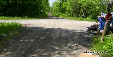
The trail looking north at North Shore Road. Garbage and recycled material
overflowing the boxes cluttered the area. That's an ATV in the distance.
 At
the beginning of this section, there's open marsh on both sides, with
evidence of beavers in places. The air was alive with birdsong.
At
the beginning of this section, there's open marsh on both sides, with
evidence of beavers in places. The air was alive with birdsong.
It's very straight and open, but as you move toward Old Marmora Road, there is increasing cover.
Two kilometres north of North Shore Lane, at Old Marmora Road (it's actually Seymour Street to the east), the trail ends and you'll be forced to walk north on Hill Road to continue. This is the official north end of the trail, 23 kilometres from the start.. However, we'll track it northward to Eldorado.
The experience changes radically here. If you like official trails and avoid jungly thickets of scrub bush and close stands of cedar, I'd call it quits here. Also, I have no idea whether parts of this northern trail are public or private.
Hill Road is mundane. There's a grassy lane on the west side that is better than the road (unless you want to get this bit over in a hurry).
You'll pass a school bus depot on your right, followed by the Madoc COPE Corporation ("Cope" stands for "constructive opportunities for progressive employment" (ouch!). Cope helps developmentally handicapped folks build skills and live healthy happy lives.
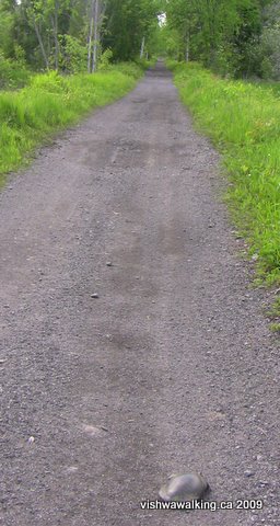
North of North Shore Road, looking north:
A turtle shares the road with me.
At St. Lawrence Street West, the main village will be on your right, to the east. Continue over the road with the Madoc Co-Operative to the right. have a look at the old the grain feed supply building. This is an interesting structure; check out the back end with its broken windows high up. Don't be fooled; this place is still in operation.
The most straightforward northward route, and the continuance of the old rail line is slightly east on St. Lawrence West, behind the fire station. Imagine Hill Avenue continuing north in a slow curve. Stay to the far left, on the west side of the station and follow the road past the helicopter pad on your right. The road curves gently to the left. When the main road curves sharply to the right, continue the slow curve north. You'll see two northward trails (heading off the "main" road). The first is more interesting, while the second, through more open territory, is easier. Both will get you to Deer Creek.
The trail starting behind the Co-op is in some ways more interesting.
There's a pile of busted up wooden pallets at the back of the lot.
Walk north of the white fuel tanks and around the pallets. Behind that you'll see a somewhat overgrown trail. A red circle (the "No trespassing" symbol) indicates the trail. (Remember, we're off the "official trail now.)
Watch closely; it's not a well-used trail. There's one little jog to the right followed by a left turn.
It's only about 700 metres from St. Lawrence Street West to Deer Creek. In early June the creek runs at least three feet deep and it's muddy.
This is what I wrote at this point, in June, 2009:
Here's the dilemma: do you walk eastward along the creek to Whytock Park (see below) to the bridge, then cut back to the trail, or do you partially strip down and wade the creek? Your choice. A snowmobile sign indicating the continuance of the trail tantalizes you on the north bank.
I stripped down and waded. It was brief, but the mud was sometimes eight or nine inches deep.
If you walk the very clear gravel road behind the fire station, you'll now find a sturdy bridge crossing Deer Creek, opened in August, 2011. (The link here is to a Community Press article
 If you read the blah-blah by politicians, you might think it's a bridge
for walkers as well as ATVs and snowmobilers. Well it is technically,
except that unless you want to continue my rather harrowing adventures
north of Highway #7 on the trail that is posted as closed, it's not
much use for walkers.) At highway #7, it is, as I wrote in 2009, "a
crazy walk."
If you read the blah-blah by politicians, you might think it's a bridge
for walkers as well as ATVs and snowmobilers. Well it is technically,
except that unless you want to continue my rather harrowing adventures
north of Highway #7 on the trail that is posted as closed, it's not
much use for walkers.) At highway #7, it is, as I wrote in 2009, "a
crazy walk."
The Deer Creek Bridge, opened in August, 2011 is mainly for ATVers and snowmobilers
and the big bucks (from snowmobile clubs and the government) were laid out because
of this. But if you are crazy enough to want to tackle the trail north of Highway #7, the bridge
does make thinks a lot easier. Photo: July 7, 2013
North of the creek, it's a short walk to the highway. It's initially marshy and probably impossible in early spring, although the original rail track looks raised but now covered with dense bush. In early June it was relatively easy to skirt the edge of the marsh just east of the old rail bed.
By the way, at the end of my day's walk, I parked my car on the highway and walked back to contemplate the creek. In the 15 to 20 minutes I was away, the police tagged (but did not ticket) my car; it's not a good parking spot if you plan a walk of any length.
North of Highway #7 to Mill Road is a crazy walk. It's an indication of what you'll have to endure if you want to reach Eldorado. I repeat — A WARNING: There are some sections here that are difficult and overgrown. I'll note them clearly. However, only undertake this section if you are on a Mission (Eldorado or bust!), if you are slightly crazy, you enjoy abusing yourself or all of the above. There's also mucho poison ivy here.
It starts innocuously enough. The trail is clear and straight, if overgrown. You'll shortly come upon a right turn in the trail with old snowmobile signs indicating the way to Eldorado. Ignore them unless you want to curve north- eastward to join Highway #62. (If you do try this one out, there's a pocket of marsh just before the highway. It might be best to leave the trail and skirt it if you want to stay dry. The trail exits over the lawn between two houses and over the highway to I don't know where.)
Back to the main trail: ignoring the swing right, continue straight along. The route remains clear, but is definitely seldom used. On either side muddy ditches keep you on the straight and narrow. However, serious poison ivy on the central portion of the trial might force you to the wet spots at times.
In just over half a kilometre, you'll come to a farmer's tracks crossing the trail. If you go left, you can follow a path northeastward (it heads initially for the radio tower) to just south of a lumber yard, or around the yard on the west side to a road that runs by a little quarry belonging to Upper Canada Stone Company. The company owns the mineral processing and packaging plant you can see on the east side of Highway #62 a little farther north. A short distance later the road reaches the highway.
Again, back to the main trail: The farmer's tracks also lead to the left (west) and out into a field. However, despite initial impressions, the actual rail bed continues northward on the other side of the farmer's track. Strike boldly into the ticket and you'll see the rail bed. This is definitely not for the casual walker. Scrub brush, hawthorn and vines conspire to keep you out. An easier route would be to head left on the farmer's tracks, then northward along the edge of the field.
However you do this section (purists will want to do the actual rail bed and sensible people will take the field), you will eventually have to take to the rail bed as it crosses the marsh. It's crazy here: the vines get thicker, the thorns bigger and the poison ivy doesn't let up. Nevertheless, it's the only way across the marsh.
Now the kicker: the bridge is out. There's about thirty feet of opening to cross where there was once a bridge and about 15 feet of stream. The stream is shallow and muddy. Bring your wading slippers.
You'll have to slide down the bank to the river. Once over, you'll have to clamber up the other side, where you'll find a faint trail. However, things improve rapidly. The trail is less cluttered and there's less poison ivy. As you leave the edge of the marsh, the trail opens up nicely. Unfortunately, you'll also have to walk by a number of old appliances dumped unceremoniously into the woods. After this, the trail joins a larger track and the last short section to the road is a breeze.
Unless you have arranged a shuttle, you'll may now have to consider the walk back. As the thorns and vines close in again, keep this victorious thought in your head: you made it through!
Rating: Hill Road section: .
Easy. North of Highway #7 at the point the trail erodes: I
can't
really rate this. As mentioned, it's only for those foolish enough to
put up with a lot of physical abuse in the name of fun.
Running Total: 26.5
From North Shore Lane (which is a private road), the trail heads through open marsh.
Local residents on this lane put their recycled
material in bins at the juncture of the lane and the trail. On the day
I walked this section, it was an absolute mess. Two
ATVs sputtered northward past the mess. It did not bode well.However, the marsh to the north has lots going on. It extends pretty well to just short of Old Marmora Road.
The trail looking north at North Shore Road. Garbage and recycled material
overflowing the boxes cluttered the area. That's an ATV in the distance.
At
the beginning of this section, there's open marsh on both sides, with
evidence of beavers in places. The air was alive with birdsong.It's very straight and open, but as you move toward Old Marmora Road, there is increasing cover.
Two kilometres north of North Shore Lane, at Old Marmora Road (it's actually Seymour Street to the east), the trail ends and you'll be forced to walk north on Hill Road to continue. This is the official north end of the trail, 23 kilometres from the start.. However, we'll track it northward to Eldorado.
The experience changes radically here. If you like official trails and avoid jungly thickets of scrub bush and close stands of cedar, I'd call it quits here. Also, I have no idea whether parts of this northern trail are public or private.
Hill Road is mundane. There's a grassy lane on the west side that is better than the road (unless you want to get this bit over in a hurry).
You'll pass a school bus depot on your right, followed by the Madoc COPE Corporation ("Cope" stands for "constructive opportunities for progressive employment" (ouch!). Cope helps developmentally handicapped folks build skills and live healthy happy lives.
North of North Shore Road, looking north:
A turtle shares the road with me.
At St. Lawrence Street West, the main village will be on your right, to the east. Continue over the road with the Madoc Co-Operative to the right. have a look at the old the grain feed supply building. This is an interesting structure; check out the back end with its broken windows high up. Don't be fooled; this place is still in operation.
The most straightforward northward route, and the continuance of the old rail line is slightly east on St. Lawrence West, behind the fire station. Imagine Hill Avenue continuing north in a slow curve. Stay to the far left, on the west side of the station and follow the road past the helicopter pad on your right. The road curves gently to the left. When the main road curves sharply to the right, continue the slow curve north. You'll see two northward trails (heading off the "main" road). The first is more interesting, while the second, through more open territory, is easier. Both will get you to Deer Creek.
The trail starting behind the Co-op is in some ways more interesting.
There's a pile of busted up wooden pallets at the back of the lot.
Walk north of the white fuel tanks and around the pallets. Behind that you'll see a somewhat overgrown trail. A red circle (the "No trespassing" symbol) indicates the trail. (Remember, we're off the "official trail now.)
Watch closely; it's not a well-used trail. There's one little jog to the right followed by a left turn.
It's only about 700 metres from St. Lawrence Street West to Deer Creek. In early June the creek runs at least three feet deep and it's muddy.
This is what I wrote at this point, in June, 2009:
Here's the dilemma: do you walk eastward along the creek to Whytock Park (see below) to the bridge, then cut back to the trail, or do you partially strip down and wade the creek? Your choice. A snowmobile sign indicating the continuance of the trail tantalizes you on the north bank.
I stripped down and waded. It was brief, but the mud was sometimes eight or nine inches deep.
If you walk the very clear gravel road behind the fire station, you'll now find a sturdy bridge crossing Deer Creek, opened in August, 2011. (The link here is to a Community Press article
If you read the blah-blah by politicians, you might think it's a bridge
for walkers as well as ATVs and snowmobilers. Well it is technically,
except that unless you want to continue my rather harrowing adventures
north of Highway #7 on the trail that is posted as closed, it's not
much use for walkers.) At highway #7, it is, as I wrote in 2009, "a
crazy walk." The Deer Creek Bridge, opened in August, 2011 is mainly for ATVers and snowmobilers
and the big bucks (from snowmobile clubs and the government) were laid out because
of this. But if you are crazy enough to want to tackle the trail north of Highway #7, the bridge
does make thinks a lot easier. Photo: July 7, 2013
North of the creek, it's a short walk to the highway. It's initially marshy and probably impossible in early spring, although the original rail track looks raised but now covered with dense bush. In early June it was relatively easy to skirt the edge of the marsh just east of the old rail bed.
By the way, at the end of my day's walk, I parked my car on the highway and walked back to contemplate the creek. In the 15 to 20 minutes I was away, the police tagged (but did not ticket) my car; it's not a good parking spot if you plan a walk of any length.
North of Highway #7 to Mill Road is a crazy walk. It's an indication of what you'll have to endure if you want to reach Eldorado. I repeat — A WARNING: There are some sections here that are difficult and overgrown. I'll note them clearly. However, only undertake this section if you are on a Mission (Eldorado or bust!), if you are slightly crazy, you enjoy abusing yourself or all of the above. There's also mucho poison ivy here.
It starts innocuously enough. The trail is clear and straight, if overgrown. You'll shortly come upon a right turn in the trail with old snowmobile signs indicating the way to Eldorado. Ignore them unless you want to curve north- eastward to join Highway #62. (If you do try this one out, there's a pocket of marsh just before the highway. It might be best to leave the trail and skirt it if you want to stay dry. The trail exits over the lawn between two houses and over the highway to I don't know where.)
Back to the main trail: ignoring the swing right, continue straight along. The route remains clear, but is definitely seldom used. On either side muddy ditches keep you on the straight and narrow. However, serious poison ivy on the central portion of the trial might force you to the wet spots at times.
In just over half a kilometre, you'll come to a farmer's tracks crossing the trail. If you go left, you can follow a path northeastward (it heads initially for the radio tower) to just south of a lumber yard, or around the yard on the west side to a road that runs by a little quarry belonging to Upper Canada Stone Company. The company owns the mineral processing and packaging plant you can see on the east side of Highway #62 a little farther north. A short distance later the road reaches the highway.
Again, back to the main trail: The farmer's tracks also lead to the left (west) and out into a field. However, despite initial impressions, the actual rail bed continues northward on the other side of the farmer's track. Strike boldly into the ticket and you'll see the rail bed. This is definitely not for the casual walker. Scrub brush, hawthorn and vines conspire to keep you out. An easier route would be to head left on the farmer's tracks, then northward along the edge of the field.
However you do this section (purists will want to do the actual rail bed and sensible people will take the field), you will eventually have to take to the rail bed as it crosses the marsh. It's crazy here: the vines get thicker, the thorns bigger and the poison ivy doesn't let up. Nevertheless, it's the only way across the marsh.
Now the kicker: the bridge is out. There's about thirty feet of opening to cross where there was once a bridge and about 15 feet of stream. The stream is shallow and muddy. Bring your wading slippers.
You'll have to slide down the bank to the river. Once over, you'll have to clamber up the other side, where you'll find a faint trail. However, things improve rapidly. The trail is less cluttered and there's less poison ivy. As you leave the edge of the marsh, the trail opens up nicely. Unfortunately, you'll also have to walk by a number of old appliances dumped unceremoniously into the woods. After this, the trail joins a larger track and the last short section to the road is a breeze.
Unless you have arranged a shuttle, you'll may now have to consider the walk back. As the thorns and vines close in again, keep this victorious thought in your head: you made it through!
Rating:
Hill Road section: .
Easy. North of Highway #7 at the point the trail erodes: I
can't
really rate this. As mentioned, it's only for those foolish enough to
put up with a lot of physical abuse in the name of fun.Walked:
June 4, 5, 12, 2009
Northward: Mill Road to the connection with the Hastings Heritage Trail
Back to the Trail of Two Lakes Introduction and the first part of the trail
Back to main Hastings Heritage Trail page
Back to the top of the pageBack to the Trail of Two Lakes Introduction and the first part of the trail
Back to main Hastings Heritage Trail page
Home | Contact Us | Site Map
Page created: March 12, 2009
Updated: August 6, 2013