Vishwawalking explained
 Ratings Explained
Vishwawalks
Parks, etc.
Funky Places
Future walks
Food
Gear
Get Lost
Good reads
Links
Right to Ramble
Site map
Contact us
Vishwawalking
Cataraqui Trail
The Cataraqui Trail
officially runs from Strathcona, a little village with a paper mill in
it, just north of Napanee, all the way to Smith Falls. In fact, the
rail line runs right into Napanee and we'll start our walk there. The
old Bay of Quinte railroad, which was eventually taken over by the
Canadian National Railroad runs into live tracks in Napanee. I've used
the little Via Rail station on Railway Street, just off Centre Street
North. The rail line continues westward and south, but as it
involves walking next to live tracks for some length, we'll explore
that some other time.
The rail bed that is now the Cataraqui was part of a number of companies that bought and sold rail line through the 19th century. See the Bay of Quinte Railway entry in my my rails to trail section for a more detailed history. Its last owner was the Canadian National Railways. For a good thorough history see here; the latter link shows how the present-day Cataraqui trail was built in bits and pieces by different companies and by companies that changed names as circumstances changed.
In 1910, Mackenzie and Mann bought the BQR for their Canadian Northern Ontario Railway, which was part of their larger Canadian Northern Railway. They upgraded the tracks from Deseronto to Sydenham and in 1918 the line became part of the Toronto to Ottawa mainline. In the same year, the company was transferred to the Canadian National Railway.
Through all this, the Government of Canada was involved in shoring up railway companies that fell into debt. Because it was an essential service, the government couldn't afford to let them fold. The Canadian people, therefore, had a huge hand in maintaining and building our early systems of travel. While some capitalists came and went, many made money from their railway endeavours ("pioneers," etc. etc.) but bailed with their money when their businesses threatened to die. Despite colourful myths about rugged individualists carving out our rail system, much of it was shored up by public money.
The Sydenham to Smith Falls section of the Cataraqui Trail was abandoned in 1986. The track from Smith Falls to Ottawa is still live and now used by Via Rail, the passenger service.
The official Cataraqui Trail has an active Friends of the Cataraqui Trail association.
 Warning!
See the "how to get there" section below if you prefer not to cross the
live tracks to get to the abandoned tracks; Via Rail has a sign warning
you not to cross.
Warning!
See the "how to get there" section below if you prefer not to cross the
live tracks to get to the abandoned tracks; Via Rail has a sign warning
you not to cross.
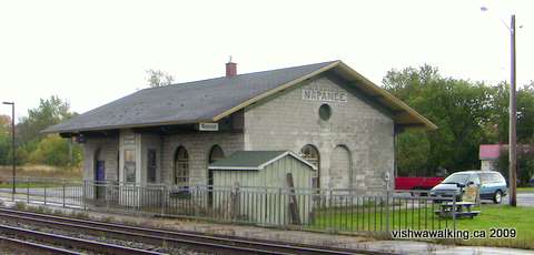
The Napanee railway station was originally built for the Grand Trunk Railway.
Those are live tracks with freight and fast-moving Via Rail trains running on them.
The location of the station on some maps is questionable. The MapSource (Garmin) topo, for example is badly distorted and Google maps hasn't got it right either.
The rails (with no trains on them!) are still in for this initial section, so you'll have to choose between a narrow section of gravel path beside the rails or walking between the rails. I found walking between the rails easiest although walking on the ties seriously messes with your natural walking rhythm.
Immediately after the old rail station, you'll pass the Napanee water tower and an intriguing old abandoned building that deserves more inspection at another time. After that it's pretty mundane, passing industrial wastelands on the left and high wooden fencing protecting suburban houses on the right.
After Industrial Boulevard, the rail crosses Camden Road (again , be careful with maps -- Google has misnamed this street). You have to clamber down from the rail bed to get across it.
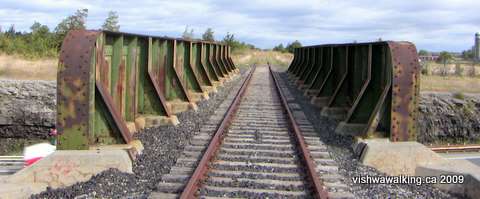 At
the 1.6-kilometre mark, you'll cross the iron bridge spanning
Highway#401. The highway cuts between the rock here, in a mini-"canyon."
At
the 1.6-kilometre mark, you'll cross the iron bridge spanning
Highway#401. The highway cuts between the rock here, in a mini-"canyon."
The sides of the bridge are slightly too high to get a view from the middle; you'll have to be content watching from the sides as the cars and trucks whiz by.
The sides of the bridge over Highway #401 are slightly too high to see over.
From the bridge it's pretty straight walking for a while. There are a few weeds cluttering the track, but nothing too serious. Farms and fields take over as the hum of the highway recedes.
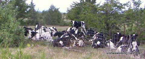 On
the fall day I walked this section, there was a bit of a breeze.
It blew into quite gale with steady rain coming at me almost
horizontally. It's open and not the best place to be if there is
rain or wind.
On
the fall day I walked this section, there was a bit of a breeze.
It blew into quite gale with steady rain coming at me almost
horizontally. It's open and not the best place to be if there is
rain or wind.
These cows seemed to know serious weather was on its way and were hunkered together
in a protected spot.
It's a straight and open two-kilometre slog to the first railway spur that heads north. The spur heads north to the Goodyear plant (see the red box below).
Some 400 metres from the point it started, the Goodyear spur has a short section that rejoins the main track (i.e., the main spur heads north, but a short section returns to the main track). Not much farther on, the tracks end. after a little gully, the trail now turns into a pleasant two-track path, with swamp , woodland and civilization not far away.
About 2.3 kilometres from where the tracks end, the trail opens onto a gravel road, with fields to the north and farms some distance off to the right, followed by areas of land churned up by big machines. The road continues for less than half a kilometre, passing through a set of open chain-link gates before reaching County Road #16.
Head north briefly on County Road #16, then turn right into the trucking yard. Stay close to the road going down into the Strathciona Paper yard, but stick to the high ground. You'll see a gravel road and then an old shed on your left. Climb over the guard/bumper rail and head straight on, to the right of the shed. The start of the trial will be clear
You can also head a little farther on County Road #16 and head right onto Finlay street which will lead you directly to the start of the trail..
Walked October 6, 7, 2009
How to get there: From Highway #401 take the Highway #41 exit into Napanee and head south 1.6 kilometres on #41 (which is Centre Street North). You'll pass the first set of lights (Richmond Boulevard) and turn left (east) on Isabella Street East. A block away is John Street turn left (north) here and drive to the top of the street.
John Street goes south past Highway #2 almost to the river, so if you're coming in from Highway #2, John Street is just east of Centre Street North and just west of East Street.
If you visit the station first, you'll have to cross a couple of sections of live track to get to the abandoned rail; Via rail has a sign or two warning you not to do that. If you want to avoid the live rails, as you come south from the #401, turn left a little earlier, at Advance Avenue. Then make the first right (south) turn onto Dairy Avenue. You'll curve around and cross the abandoned tracks. Just to the east of the tracks is a little area where you can park.
More options: If you head east from Centre Street North at Industrial Avenue, there's a little plaza with a restaurant in it just before you cross the tracks. There's a paved parking lot here and it's less than a kilometre walk to the train station.
The rail bed that is now the Cataraqui was part of a number of companies that bought and sold rail line through the 19th century. See the Bay of Quinte Railway entry in my my rails to trail section for a more detailed history. Its last owner was the Canadian National Railways. For a good thorough history see here; the latter link shows how the present-day Cataraqui trail was built in bits and pieces by different companies and by companies that changed names as circumstances changed.
In 1910, Mackenzie and Mann bought the BQR for their Canadian Northern Ontario Railway, which was part of their larger Canadian Northern Railway. They upgraded the tracks from Deseronto to Sydenham and in 1918 the line became part of the Toronto to Ottawa mainline. In the same year, the company was transferred to the Canadian National Railway.
Through all this, the Government of Canada was involved in shoring up railway companies that fell into debt. Because it was an essential service, the government couldn't afford to let them fold. The Canadian people, therefore, had a huge hand in maintaining and building our early systems of travel. While some capitalists came and went, many made money from their railway endeavours ("pioneers," etc. etc.) but bailed with their money when their businesses threatened to die. Despite colourful myths about rugged individualists carving out our rail system, much of it was shored up by public money.
The Sydenham to Smith Falls section of the Cataraqui Trail was abandoned in 1986. The track from Smith Falls to Ottawa is still live and now used by Via Rail, the passenger service.
The official Cataraqui Trail has an active Friends of the Cataraqui Trail association.
The Unofficial Start to the Cataraqui Trail
Napanee to Strathcona
The old Grand Trunk Railway station at 301 John Street in Napanee, K7R 3L3, is now the Via Rail station. Total: 14.8
Running total: 14.8
Running total: 14.8
Warning!
See the "how to get there" section below if you prefer not to cross the
live tracks to get to the abandoned tracks; Via Rail has a sign warning
you not to cross. The Napanee railway station was originally built for the Grand Trunk Railway.
Those are live tracks with freight and fast-moving Via Rail trains running on them.
The location of the station on some maps is questionable. The MapSource (Garmin) topo, for example is badly distorted and Google maps hasn't got it right either.
The rails (with no trains on them!) are still in for this initial section, so you'll have to choose between a narrow section of gravel path beside the rails or walking between the rails. I found walking between the rails easiest although walking on the ties seriously messes with your natural walking rhythm.
Immediately after the old rail station, you'll pass the Napanee water tower and an intriguing old abandoned building that deserves more inspection at another time. After that it's pretty mundane, passing industrial wastelands on the left and high wooden fencing protecting suburban houses on the right.
After Industrial Boulevard, the rail crosses Camden Road (again , be careful with maps -- Google has misnamed this street). You have to clamber down from the rail bed to get across it.
At
the 1.6-kilometre mark, you'll cross the iron bridge spanning
Highway#401. The highway cuts between the rock here, in a mini-"canyon."The sides of the bridge are slightly too high to get a view from the middle; you'll have to be content watching from the sides as the cars and trucks whiz by.
The sides of the bridge over Highway #401 are slightly too high to see over.
From the bridge it's pretty straight walking for a while. There are a few weeds cluttering the track, but nothing too serious. Farms and fields take over as the hum of the highway recedes.
On
the fall day I walked this section, there was a bit of a breeze.
It blew into quite gale with steady rain coming at me almost
horizontally. It's open and not the best place to be if there is
rain or wind.These cows seemed to know serious weather was on its way and were hunkered together
in a protected spot.
It's a straight and open two-kilometre slog to the first railway spur that heads north. The spur heads north to the Goodyear plant (see the red box below).
The
"Goodyear spur" heads north from the main trail. It's abandoned,
but the tracks are still in.. You'll see the massive Goodyear plant
as the curve of the railway straightens. It's a pleasant walk
through fields and lightly wooded areas.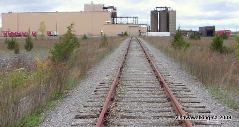 At about the 1.3 kilometre point, you'll run into a fence surrounding the plant. At about the 1.3 kilometre point, you'll run into a fence surrounding the plant.Here you have choices but there's not really much to see between here and Goodyear Road, except perhaps a glimpse of a solar farm. Your choices; 1) Turn back; this factory is more than you wanted to see anyway.. The rear of the Goodyear plant with the (abandoned) rails leading up and into it. 2) Walk around the plant to Goodyear Road. Turn right (east) and follow the fence. At the southeast end of the Goodyear fence, where it turns north, there is a corridor between it and the solar farm fence The solar farm fence is a serious link and barbed-wire affair. In the corridor you are walking there are some marshy bits, but if you stay close to the Goodyear fence you'll be alright. The solar panels takes up 90 acres. Although some local politicians were not happy with the location of the plant, provincial regulations do allow for solar plants to locate on prime agricultural land. Some environmentalists are also not happy with this move; there are also rare birds in the area say Wildlife Preservation Canada. The aforementioned society has sofened its approach since I first wrote this, but they're still concerned. The farm is on 250 acres, though some reports say not all of that will be used as some areas near creeks is protected. Others object to prime agricultural land being swallowed up by the farm. Nevertheless, most reports rate it as the biggest solar farm in North America, and the second biggest in the world. Peek over the fence and be awed.... Actually, other than a few solar panels in the distance, it's mostly open scrub land., at least at the Goodyear end. If you Google solar power and environmental concerns, you will see a number of articles that refer to Napanee and this problem. Back to the corridor: when the northern stretch of the Goodyear fence ends, you can follow it westward to a road that leads up to Goodyear Road. be aware that you are on Goodyear land here. Alternatively you can do a bit of easy bushwhacking straight through the scrub to the road. This route adds about .4 kilometres to your trip northward, compared with the final option below. 3) This route is not recommended. The Goodyear people have dark secrets to keep and they don't want you on their land. However, back where the tracks disappear into the Goodyear compound and into the factory, there was in 2009 an opening wide enough in the gate to get through easily. Then you could walk around to the northern end, where there is no opening in the fence. It requires climbing. [2021: I do not know if the fence opening exists 12 years after my adventure.] 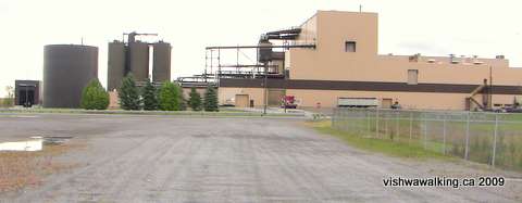 When
I walked this section, I was seriously considering walking to the main
gate to walk around the fence, when I noticed a van and two cars
speeding from the factory across the open terrain toward me.
Nothing like a little adrenalin to improve my fence-climbing skills. When
I walked this section, I was seriously considering walking to the main
gate to walk around the fence, when I noticed a van and two cars
speeding from the factory across the open terrain toward me.
Nothing like a little adrenalin to improve my fence-climbing skills.Photos from the inside: part of the Goodyear factory. As I scaled the fence, the van driver exited his machine shouting. I concentrated on my task until I had the chain link safely between me and my pursuers. Then I turned to chat (I think this part surprised them). I was told was on private land and was trespassing. I assured them I didn't steal anything. "Did you take pictures?" I was asked. I cannot tell a lie. I did. "That's stealing," I was told. Even employees cannot take cameras into the factory. "What is this place? " I asked. "Can't tell you." I may have imagined it, but I thought the person being so secret was a little embarrassed when I read "Goodyear" from of his name tag. Nevertheless he was pleasant enough and told me about the solar plant. I promised I would not transgress the Goodyear holy ground again, but still had to get back to the tracks to the south. "Why? You got a train to catch?" he joked. I told him I did. |
Some 400 metres from the point it started, the Goodyear spur has a short section that rejoins the main track (i.e., the main spur heads north, but a short section returns to the main track). Not much farther on, the tracks end. after a little gully, the trail now turns into a pleasant two-track path, with swamp , woodland and civilization not far away.
About 2.3 kilometres from where the tracks end, the trail opens onto a gravel road, with fields to the north and farms some distance off to the right, followed by areas of land churned up by big machines. The road continues for less than half a kilometre, passing through a set of open chain-link gates before reaching County Road #16.
Head north briefly on County Road #16, then turn right into the trucking yard. Stay close to the road going down into the Strathciona Paper yard, but stick to the high ground. You'll see a gravel road and then an old shed on your left. Climb over the guard/bumper rail and head straight on, to the right of the shed. The start of the trial will be clear
You can also head a little farther on County Road #16 and head right onto Finlay street which will lead you directly to the start of the trail..
How to get there: From Highway #401 take the Highway #41 exit into Napanee and head south 1.6 kilometres on #41 (which is Centre Street North). You'll pass the first set of lights (Richmond Boulevard) and turn left (east) on Isabella Street East. A block away is John Street turn left (north) here and drive to the top of the street.
John Street goes south past Highway #2 almost to the river, so if you're coming in from Highway #2, John Street is just east of Centre Street North and just west of East Street.
If you visit the station first, you'll have to cross a couple of sections of live track to get to the abandoned rail; Via rail has a sign or two warning you not to do that. If you want to avoid the live rails, as you come south from the #401, turn left a little earlier, at Advance Avenue. Then make the first right (south) turn onto Dairy Avenue. You'll curve around and cross the abandoned tracks. Just to the east of the tracks is a little area where you can park.
More options: If you head east from Centre Street North at Industrial Avenue, there's a little plaza with a restaurant in it just before you cross the tracks. There's a paved parking lot here and it's less than a kilometre walk to the train station.
Home | Contact Us | Site Map
Page
created: October 6, 2009
Walked: October, 2009
Updated: September 7, 2021
Walked: October, 2009
Updated: September 7, 2021