About Us
Vishwawalking explained
 Ratings Explained
Vishwawalks
Day walks
Funky Places
Future walks
Food
Gear
Get Lost
Right to Ramble
Good reads
Site map
Links
Contact us
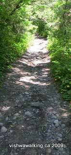
Once the trail clears the initial greenery at Tinkerville road, the unopened road allowance looks like this, climbing steadily as it gets into the oak Ridges Moraine. Small rocks and sand make up much of the trail bed. That's poison ivy lining the sides of the trail.
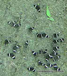
These baby butterflies were clustered in the middle of one of the side trails just east of Pine Grove Lane.
Vishwawalking
Ganaraska Hiking Trail
Hope Township 7th Line to the
Ganaraska Forest Centre
Ganaraska Hiking Trail
Hope Township 7th Line to the
Ganaraska Forest Centre
3)
Seventh Line to Tinkerville Road (Garden Hill)
Total: 4.3 kilometres
Running total: 21.3 kilometres
Head straight west down the 7th line to Grist Mill Road. You'll be walking by corn and soy bean fields. Grist Mill takes a dog leg before reaching Fudges Mills (also known as Fudge's Mills).
 Until
recently the mill still ran under water power; the 2006 Ganaraska Trail
guide book recommends you go in and have a look "if Fudge's Mill is
opened." Unfortunately it's definitely abandoned now.
Until
recently the mill still ran under water power; the 2006 Ganaraska Trail
guide book recommends you go in and have a look "if Fudge's Mill is
opened." Unfortunately it's definitely abandoned now.
Unfortunately I could find no online information on the mid-19th century mill; this is definitely a library project.
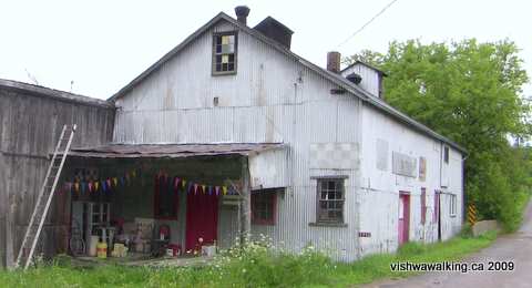
Fudges Mill, Grist Mill Road, Campbellcroft.
Apparently the mill was most recently operated by Robert Fudge who was a councillor on the Port Hope Council between 2007 and 2010. Here's a picture of him on the council.
Although it looks like the place has been closed for some years, there is still grain on the floor and I'd guess it was operated in the early 2000s. It's the highlight of this stretch of the walk.
From the mill it's up the hill to past some barns on the left that also appear to be unused. At Ganaraska Road turn left and walk for just over 600 metres to Tinkerville Road. After 400 metres, the road turns into an unmaintained road allowance.
Rating: Easy. Good views of
the Northumberland farmland. Fudge's Mill is a must-see.
4) Tinkerville Road to parking spot at Oak Hills Road
Total: 4.7 kilometres
Running total: 26 kilometres
N.B.: This section passes through the Ganaraska Forest. The summer of 2009 (the summer that wasn't) has caused serious erosion in some of the forest roads. It doesn't affect walking too seriously, but take care.
At the point the road ends and turns into a track, you'll see some barns off to your right and a "No snowmobiles" sign. Continue straight along the track, which now runs through some wet areas, including a little stream to the left.
The bush is mixed here, with mostly cedar, and some hardwood and pine mixed in as you move north. You'll pass under some power lines and then a field on your right. Once you move from the more green section of the trail into woods and more of a dirt trail, the poison ivy gets denser. if you stick to the trail it's not a problem, but chances are if you stray even a bit it will be into poison ivy. The dirt trail is wide, so it's not a real problem here.
Keep your eye out for some big old pines dotted along the way. The trail moves upward steadily, rising sharply as it gets near Wright Road. As you turn sharply left to Wright Road, you'll see two barriers on your right, placed to deter motorized vehicles on the Oak Ridges Trail, which joins (or leaves, depending upon your direction) the Ganaraska Trail at this point. (The Oak Ridges Trail starts in Palgrave some 130 kilometres to the west by road and ends near Gores Landing on Rice Lake, very roughly 20 kilometres to the east.)
The trail eases up to Wright Road, moving on to a mown roadside section. There are a couple of houses here. Follow the road west as it moves downhill to Thomstown, which is made up of a cluster of houses around the intersection of Wright Road and County Road #10/Perrytown Road. On the other side of County Road #10, the road is called Pine Grove Lane. There's a "no exit" sign as you enter this portion. Some maps indicate there are roads beyond the 400 metres that stretches from County Road #10, but don't believe them.
At the end of Pine Grove Lane, there's a short dirt road that continues into the bush before looping back. That's not the trail, which is pretty clear on the left-hand side of the road. The trail here is a double path, but definitely not suitable for cars.
Shortly into the woods, the trail curves to the right.
(You can take the straight-ahead trail. It leads southward briefly and crosses a little stream, curves around, crosses the stream again, and heads westward to join the main trail. As it closes in on the main trail, it parallels it for a short stretch. You'll see the main trail on your right.)
This diversion has more variety than the main trail, but it could be wet at times near the stream. In July, the stream was relatively easy to cross.
The main trail from Pine Grove Lane also curves south briefly, to skirt Robb's Hill. It's still a sharp climb in places on a sandy trail that you'll become familiar with as you move deeper into the Ganaraska Forest.
Shortly after the diversion rejoins the main rail, a dirt trail/road heads off to the south. This is the extension of Mill Street in Garden Hill. Follow it downhill and you'll come to a barn on your left and a little trailer/house on the right. Keep walking and you'll come to Ganaraska Road and Garden Hill.
 All along the way, you'll have noted
the stands of planted pine, and come to appreciate why this section of
trail is called "Pine Ridges" — although it occurred to me as I walked
these sections that it could just as well have been dubbed "Poison Ivy
Ridges."
All along the way, you'll have noted
the stands of planted pine, and come to appreciate why this section of
trail is called "Pine Ridges" — although it occurred to me as I walked
these sections that it could just as well have been dubbed "Poison Ivy
Ridges."
But that term just doesn't have the same ring to it...
The trail is at its best at points like this. Nice open stretches with some mixed
softwood and hardwood along the way. (That's poison ivy lining the road to the
right — easily avoidable at these spots if you don't go wandering.)
After Mill Street, the trail curves right then left. A sign after the second turn announces the Ganaraska Forest and warns that users must have a season's or day pass to walk/ski/ride/drive or even (in sections) be allowed to rip it to hell with an ATV. The Ganaraska Trail, however, is on road allowances, so if you stick to the trails you won't be jailed. (Actually, considering the poison ivy, you won't be inspired to leave the trail anyway.)
The Ganaraska Forest is made up of 4,200 hectares (10,400 acres) of property. Reforestration was necessary on 50 per cent of it.
Just after the sign, take the left side at the "Y" junction., then shortly thereafter jog to the right to keep to the main trail. (If you take the right trail at the "Y" it amounts to the same thing as long as you keep to the left and don't curve up the road that leads up the hill.
 As the trail/road
leads downward another road appears on the right. Some logging was
going on when I passed. I watched for a while as a dinosaur
of a machine reached out and in seconds cut and felled
a cedar two feet thick at the base.
As the trail/road
leads downward another road appears on the right. Some logging was
going on when I passed. I watched for a while as a dinosaur
of a machine reached out and in seconds cut and felled
a cedar two feet thick at the base.
There was quite a mess made by the huge machine in the woods, but I presume the work was somewhat controlled and that the move is to slowly build a more natural mixed -woods forest.
The effort to rejuvenate the Ganaraska Forest, by the way, is not always an upward journey. In the 1990s, under a repressive provincial Conservative government (the infamous Harris era), forests were assessed for "market value." It didn't matter what you were doing with the land, it was simply assessed and taxed for its potential.
"[In the mid-1990s]The Ganaraska Forest, suddenly saddled with a $150,000 tax bill on its 11,000 acres of newly- minted "residential" land, had no choice but to shed some of its property. The prospect of losing forest to developers outraged Ganaraska's chief administrator. 'Somewhere in the tax shuffle,' she complained, 'the environment got lost'" (from an Environment Probe report on taxation as a way of aiding the cause of the developer. If you want to be outraged, check this report out. The trend is not restricted to the Harris government.)
While I'm raging, I should note that as I walked past the logging, mulling on the possible pluses and minuses of these monster machines in the bush, a little dirt bike came flying over the crest of a hill. Standing two feet off the trail/road, he did not see me.
Many of the Ganaraska Forest roads, based on the sandy soil, have deep rifts in them from both vehicle abuse and water runoff. The bike/ATV crowd are certainly doing their part to erode the roads. Only 20 per cent of the trails in the Ganaraska Forest are restricted to hiking.
Not long after the logging operation, the dirt trail opens onto Oak Hill Road. It's a good parking spot. Don't park too close to the side of the road or you'll be stepping directly into poison ivy.
Rating: Easy-moderate.
5) Oak Hills Road to the Ganaraska Forest Centre
Total: 8.3 kilometres
Running total: 34.4 kilometres
Walk 500 metres west down Oak Hill Road from where the driveable part ends and turn right (north) at Walker Road. Keep on this road for just over two kilometres. It winds mostly uphill and is pleasant enough. Partway along, there's a fine view of farmland stretching to the west and north. When you turn onto the 10th Line, a little way in you'll get a second view of this farm.
Near the top of the hill, two Doberman dogs sitting in the sun on the doorstep of a house kicked up a ruckus, but they were slow to notice me and I tripled my speed to pass them, so the dogs gave up. Potential tense situation averted.
At the top of the hill, the 10th Line heads east in a hardtop road. A trail immediately north also heads eastward. The abandoned Port Hope, Lindsay and Beaverton rail line, which we walked earlier, is to the east; the 10th line passes under one of its iron bridges just a short distance away.
 We are turning left, however, onto the undriveable road
allowance. The 10th Line now moves through the Ganaraska Forest for 5.7
kilometres before meeting the Cold Springs Camp Road.
We are turning left, however, onto the undriveable road
allowance. The 10th Line now moves through the Ganaraska Forest for 5.7
kilometres before meeting the Cold Springs Camp Road.
The trail pitches down from the junction of Walker and the 10th.
The road/trail is deeply rutted by machines and by water runoff. The soil is sandy and it's understandable that a road in this section would be hard to maintain, but don't even think of taking your car down this road. You'll never get out.
The heavy rains of summer 2009, coupled with the
sandy loam of the Ganaraska Forest,and the ravages of
motorized vehicles have created a rough road west of the
juncture of Walker and the 10th line.
 This is a beautiful section. The planted softwood forests
have given way here to a fantastic hardwood forest. It's over too soon.
This is a beautiful section. The planted softwood forests
have given way here to a fantastic hardwood forest. It's over too soon.
The trail soon crosses a little stream. Further on it crosses a stream bed, but in mid-summer there was no stream.
Notice here where water has swept away some of the road; there's sand in the dried road bed that looks like road fill.
"Dead Pine Intersection" (my name for this spot): A huge dead pine sits at the intersection of these roads/trails. behind it is a living tree and behind that is a big sign laying out rules and other information concerning the forest. Out of the picture to the right is an outhouse surrounded by a ring of poison ivy. The trail follows the left road/trail up the hill.
Off to the right is an outhouse. I went dutifully off to inspect it so I could report on its state, but it was protected by a solid ring of poison ivy. Mission not accomplished. I'm dedicated but there are limits.
Stick to the left road/trail. Keep a lookout for a huge living pine on the left just off the trail. Then, farther up the hill, look to your left through the trees to see the old stone fence running parallel to the road. It's a reminder that at one time some poor farmers tried to make a go of it out here. They probably had a miserable time and destroyed the eco-system in the process.
You'll pass a trail south followed by a trail angling north and south, followed by a trail heading north. The 10th Line doesn't waver much, but the ups and downs make it more interesting than a rail bed.
You'll know you're nearing the end of the 10th when you come to a parking lot for horse trailers. From here, you can stick to the road/trail which turns into a proper road before meeting Cold Springs Camp Road. Alternatively, you can flip over to the right and take a track that leads beside the road and curves around at Cold Springs Camp Road taking you into the Ganaraska Forest Centre.
If you stick to the road, turn right along Cold Springs Camp Road and walk a few metres to the gate of the Ganaraska Forest Centre.
The centre has picnic tables to lunch on and mown grass to snooze on. After nearly 20 kilometres of walking (and more to go), I had no problem with a beautiful patch of grass beside a covered picnic area. I had it all to myself.
 The old centre, a little to the north of the centre's
gates, looks a bit like an army barracks. The new centre, as yet
unopened, is pretty flashy.
The old centre, a little to the north of the centre's
gates, looks a bit like an army barracks. The new centre, as yet
unopened, is pretty flashy.
It looks like the centre might be pushing for the conference crowd as well as schools.
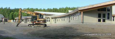
The new Ganaraska Forest Centre is a flashy-looking "green building" that appears
as if it will cater to the corporate crowd as well as school children. In August 2009, it
looked like this. Notice one of the old buildings in the far left corner.
Here's how the building contractors describe the place: "A 17,000 sq ft single-storey structure of heavy timber frame with radiant in-floor heating, planted roofs, and a rainwater harvesting system and in-line power meters encourage energy conservation by residents who stay at the centre. Designed for both school and corporate retreat functions, the facility accommodates up to 80 residents and staff. Opening is scheduled for Spring 2009" (THS Green Smart, sample projects page, accessed August, 2009).
They obviously missed the spring 2009 deadline. When I toured the grounds at 5 p.m. on an August weekday, there was not a soul around. I presume the centre will not be ready this season.
The building, according to an undated Ganaraska Forest press release, will cost $4 million.
Rating: Easy-moderate
How to get there: Port Hope is on the Highway #401 corridor along the north shore of Lake Ontario. It's just over 90 kilometres east from the #401 and Don Valley Junction in Toronto.
Take the easternmost Port Hope cutoff (County Road #28). Head north 10.4 kilometres on County Road #28 to Hope Township's 7th Line. Turn left. You'll cross Campbell Road at the 3.3 kilometre point. The trail comes north up Campbell Road and turns left (west) on the 7th Line here.
Back to Ganaraska Trail start: Port Hope to the 7th Line
Total: 4.3 kilometres
Running total: 21.3 kilometres
Head straight west down the 7th line to Grist Mill Road. You'll be walking by corn and soy bean fields. Grist Mill takes a dog leg before reaching Fudges Mills (also known as Fudge's Mills).
Until
recently the mill still ran under water power; the 2006 Ganaraska Trail
guide book recommends you go in and have a look "if Fudge's Mill is
opened." Unfortunately it's definitely abandoned now.Unfortunately I could find no online information on the mid-19th century mill; this is definitely a library project.
Fudges Mill, Grist Mill Road, Campbellcroft.
Apparently the mill was most recently operated by Robert Fudge who was a councillor on the Port Hope Council between 2007 and 2010. Here's a picture of him on the council.
Although it looks like the place has been closed for some years, there is still grain on the floor and I'd guess it was operated in the early 2000s. It's the highlight of this stretch of the walk.
From the mill it's up the hill to past some barns on the left that also appear to be unused. At Ganaraska Road turn left and walk for just over 600 metres to Tinkerville Road. After 400 metres, the road turns into an unmaintained road allowance.
Rating:
Easy. Good views of
the Northumberland farmland. Fudge's Mill is a must-see.Walked:
July 29, 2009
4) Tinkerville Road to parking spot at Oak Hills Road
Total: 4.7 kilometres
Running total: 26 kilometres
N.B.: This section passes through the Ganaraska Forest. The summer of 2009 (the summer that wasn't) has caused serious erosion in some of the forest roads. It doesn't affect walking too seriously, but take care.
At the point the road ends and turns into a track, you'll see some barns off to your right and a "No snowmobiles" sign. Continue straight along the track, which now runs through some wet areas, including a little stream to the left.
The bush is mixed here, with mostly cedar, and some hardwood and pine mixed in as you move north. You'll pass under some power lines and then a field on your right. Once you move from the more green section of the trail into woods and more of a dirt trail, the poison ivy gets denser. if you stick to the trail it's not a problem, but chances are if you stray even a bit it will be into poison ivy. The dirt trail is wide, so it's not a real problem here.
Keep your eye out for some big old pines dotted along the way. The trail moves upward steadily, rising sharply as it gets near Wright Road. As you turn sharply left to Wright Road, you'll see two barriers on your right, placed to deter motorized vehicles on the Oak Ridges Trail, which joins (or leaves, depending upon your direction) the Ganaraska Trail at this point. (The Oak Ridges Trail starts in Palgrave some 130 kilometres to the west by road and ends near Gores Landing on Rice Lake, very roughly 20 kilometres to the east.)
The Oak Ridges Moraine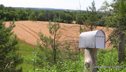 "The Oak Ridges Moraine
is more than 90 percent privately owned, with a population of more than
100,000. It crosses 32 municipalities, supplies drinking water to more
than 250,000 people, and supports related agricultural, industrial,
commercial and recreational uses." "The Oak Ridges Moraine
is more than 90 percent privately owned, with a population of more than
100,000. It crosses 32 municipalities, supplies drinking water to more
than 250,000 people, and supports related agricultural, industrial,
commercial and recreational uses." — From the "About" page of the Oak Ridges Moraine Foundation.(ORMF) A view looking south from the Oak Ridges Moraine on Wright Road just east of Thomstown. While the road sections of the trail aren't particularly inspiring in themselves, they do afford great views of the countryside. The moraine runs 160 kilometres from the Niagara escarpment in the west to the Trent River in the east. Have a look at ORMF's graphic history of the area from the ice ages. It's fantastic if you want a quick and easy guide to ice age action, and worth having a look at before you walk the area. Two million years ago, as the ice advanced and retreated, it was at times over two kilometres thick. As the ice melted, it formed two distinct lobes, with the Oak Ridges Moraine becoming part of the crack between the two lobes. Underneath the melting ice, rivers formed, carving valleys where the area's present-day rivers can be found. Initially, these rivers pushed water and sediment into the valley created by the crack, gradually filling in the crack and building it up. Further melting formed two huge lakes where parts of Ontario and the Great Lakes are now, leaving sand and sediment in a long "dam" (the moraine) between the lakes that prevented water from draining away. As the geography settled to what we are familiar with today, the Oak Ridges Moraine remained, some 200 to 300 metres above Lake Ontario. Water retained by the moraine feeds both the rivers flowing south to Lake Ontario and those flowing north into the Kawartha Lakes. Over time, the moraine developed plant life, moving from tundra to grassland to spruce fir and pine and then to huge maple and oak. In the late 1700s and 1800s, intense cutting of these trees for the shipping needs of the British was made even worse when areas were clear-cut for agriculture. By the 1900s, most farms had been abandoned and mills were forced to close as water flow dried up. The sandy soil was not appropriate for either crops or cattle. "Serious environmental problems resulted: exposed soil washed from the land and suffocated streams; snowplows had to clear sand drifts blowing across the roads; rivers flooded higher and more often after storms; streams and wells went dry in summer; there were no more local sources of wood; and wildlife vanished" (From the Oak Ridges Moraine Trail guidebook, Map 9, "Hope."). Sand dunes dotted the landscape. In the 1940s, efforts began to rebuild the watershed. Today, the Ganaraska Region Conservation Authority is mandated to rehabilitate the area. The planted stands of pines and other trees and controlled forestry is all part of that plan. |
The trail eases up to Wright Road, moving on to a mown roadside section. There are a couple of houses here. Follow the road west as it moves downhill to Thomstown, which is made up of a cluster of houses around the intersection of Wright Road and County Road #10/Perrytown Road. On the other side of County Road #10, the road is called Pine Grove Lane. There's a "no exit" sign as you enter this portion. Some maps indicate there are roads beyond the 400 metres that stretches from County Road #10, but don't believe them.
At the end of Pine Grove Lane, there's a short dirt road that continues into the bush before looping back. That's not the trail, which is pretty clear on the left-hand side of the road. The trail here is a double path, but definitely not suitable for cars.
Shortly into the woods, the trail curves to the right.
(You can take the straight-ahead trail. It leads southward briefly and crosses a little stream, curves around, crosses the stream again, and heads westward to join the main trail. As it closes in on the main trail, it parallels it for a short stretch. You'll see the main trail on your right.)
This diversion has more variety than the main trail, but it could be wet at times near the stream. In July, the stream was relatively easy to cross.
The main trail from Pine Grove Lane also curves south briefly, to skirt Robb's Hill. It's still a sharp climb in places on a sandy trail that you'll become familiar with as you move deeper into the Ganaraska Forest.
Shortly after the diversion rejoins the main rail, a dirt trail/road heads off to the south. This is the extension of Mill Street in Garden Hill. Follow it downhill and you'll come to a barn on your left and a little trailer/house on the right. Keep walking and you'll come to Ganaraska Road and Garden Hill.
All along the way, you'll have noted
the stands of planted pine, and come to appreciate why this section of
trail is called "Pine Ridges" — although it occurred to me as I walked
these sections that it could just as well have been dubbed "Poison Ivy
Ridges."But that term just doesn't have the same ring to it...
The trail is at its best at points like this. Nice open stretches with some mixed
softwood and hardwood along the way. (That's poison ivy lining the road to the
right — easily avoidable at these spots if you don't go wandering.)
After Mill Street, the trail curves right then left. A sign after the second turn announces the Ganaraska Forest and warns that users must have a season's or day pass to walk/ski/ride/drive or even (in sections) be allowed to rip it to hell with an ATV. The Ganaraska Trail, however, is on road allowances, so if you stick to the trails you won't be jailed. (Actually, considering the poison ivy, you won't be inspired to leave the trail anyway.)
The Ganaraska Forest is made up of 4,200 hectares (10,400 acres) of property. Reforestration was necessary on 50 per cent of it.
Just after the sign, take the left side at the "Y" junction., then shortly thereafter jog to the right to keep to the main trail. (If you take the right trail at the "Y" it amounts to the same thing as long as you keep to the left and don't curve up the road that leads up the hill.
As the trail/road
leads downward another road appears on the right. Some logging was
going on when I passed. I watched for a while as a dinosaur
of a machine reached out and in seconds cut and felled
a cedar two feet thick at the base. There was quite a mess made by the huge machine in the woods, but I presume the work was somewhat controlled and that the move is to slowly build a more natural mixed -woods forest.
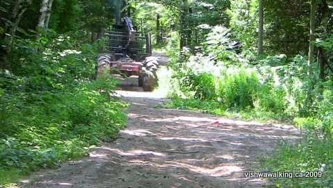
This logging truck trundled west down the trail in the midst of the forest, where two
trucks were involved in selective thinning. I'm sounding like a broken record here, but
when trucks like this pass, it's hard to quickly find a good place to step off the trail and avoid
the poison ivy. Plan ahead: start looking for a spot as soon as you hear a vehicle approach, be
it this monster, an ATV or a motorcycle. At a later section where there were severe washouts, I passed
a person traversing the trail in a 4-wheel on-road vehicle.Not something I'd want to try.
The effort to rejuvenate the Ganaraska Forest, by the way, is not always an upward journey. In the 1990s, under a repressive provincial Conservative government (the infamous Harris era), forests were assessed for "market value." It didn't matter what you were doing with the land, it was simply assessed and taxed for its potential.
"[In the mid-1990s]The Ganaraska Forest, suddenly saddled with a $150,000 tax bill on its 11,000 acres of newly- minted "residential" land, had no choice but to shed some of its property. The prospect of losing forest to developers outraged Ganaraska's chief administrator. 'Somewhere in the tax shuffle,' she complained, 'the environment got lost'" (from an Environment Probe report on taxation as a way of aiding the cause of the developer. If you want to be outraged, check this report out. The trend is not restricted to the Harris government.)
While I'm raging, I should note that as I walked past the logging, mulling on the possible pluses and minuses of these monster machines in the bush, a little dirt bike came flying over the crest of a hill. Standing two feet off the trail/road, he did not see me.
Many of the Ganaraska Forest roads, based on the sandy soil, have deep rifts in them from both vehicle abuse and water runoff. The bike/ATV crowd are certainly doing their part to erode the roads. Only 20 per cent of the trails in the Ganaraska Forest are restricted to hiking.
Not long after the logging operation, the dirt trail opens onto Oak Hill Road. It's a good parking spot. Don't park too close to the side of the road or you'll be stepping directly into poison ivy.
Rating:
Easy-moderate.5) Oak Hills Road to the Ganaraska Forest Centre
Total: 8.3 kilometres
Running total: 34.4 kilometres
Walk 500 metres west down Oak Hill Road from where the driveable part ends and turn right (north) at Walker Road. Keep on this road for just over two kilometres. It winds mostly uphill and is pleasant enough. Partway along, there's a fine view of farmland stretching to the west and north. When you turn onto the 10th Line, a little way in you'll get a second view of this farm.
Near the top of the hill, two Doberman dogs sitting in the sun on the doorstep of a house kicked up a ruckus, but they were slow to notice me and I tripled my speed to pass them, so the dogs gave up. Potential tense situation averted.
At the top of the hill, the 10th Line heads east in a hardtop road. A trail immediately north also heads eastward. The abandoned Port Hope, Lindsay and Beaverton rail line, which we walked earlier, is to the east; the 10th line passes under one of its iron bridges just a short distance away.
We are turning left, however, onto the undriveable road
allowance. The 10th Line now moves through the Ganaraska Forest for 5.7
kilometres before meeting the Cold Springs Camp Road.The trail pitches down from the junction of Walker and the 10th.
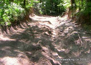
The road/trail is deeply rutted by machines and by water runoff. The soil is sandy and it's understandable that a road in this section would be hard to maintain, but don't even think of taking your car down this road. You'll never get out.
The heavy rains of summer 2009, coupled with the
sandy loam of the Ganaraska Forest,and the ravages of
motorized vehicles have created a rough road west of the
juncture of Walker and the 10th line.
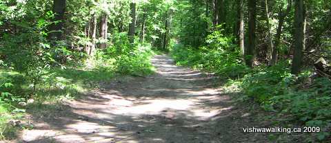
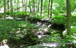
This is a beautiful section. The planted softwood forests
have given way here to a fantastic hardwood forest. It's over too soon.The trail soon crosses a little stream. Further on it crosses a stream bed, but in mid-summer there was no stream.
Notice here where water has swept away some of the road; there's sand in the dried road bed that looks like road fill.
A little stream flows through a beautiful hardwood
section of the forest just east of Walker Road
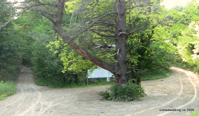
At the two-kilometre point (almost), there's a huge Ganaraska Forest sign laying out the rules for its use. Two big trees sit in an open space from whence two roads fork westward. One of the big old trees is a dead pine.
section of the forest just east of Walker Road
At the two-kilometre point (almost), there's a huge Ganaraska Forest sign laying out the rules for its use. Two big trees sit in an open space from whence two roads fork westward. One of the big old trees is a dead pine.
"Dead Pine Intersection" (my name for this spot): A huge dead pine sits at the intersection of these roads/trails. behind it is a living tree and behind that is a big sign laying out rules and other information concerning the forest. Out of the picture to the right is an outhouse surrounded by a ring of poison ivy. The trail follows the left road/trail up the hill.
Off to the right is an outhouse. I went dutifully off to inspect it so I could report on its state, but it was protected by a solid ring of poison ivy. Mission not accomplished. I'm dedicated but there are limits.
Stick to the left road/trail. Keep a lookout for a huge living pine on the left just off the trail. Then, farther up the hill, look to your left through the trees to see the old stone fence running parallel to the road. It's a reminder that at one time some poor farmers tried to make a go of it out here. They probably had a miserable time and destroyed the eco-system in the process.
You'll pass a trail south followed by a trail angling north and south, followed by a trail heading north. The 10th Line doesn't waver much, but the ups and downs make it more interesting than a rail bed.
You'll know you're nearing the end of the 10th when you come to a parking lot for horse trailers. From here, you can stick to the road/trail which turns into a proper road before meeting Cold Springs Camp Road. Alternatively, you can flip over to the right and take a track that leads beside the road and curves around at Cold Springs Camp Road taking you into the Ganaraska Forest Centre.
If you stick to the road, turn right along Cold Springs Camp Road and walk a few metres to the gate of the Ganaraska Forest Centre.
The centre has picnic tables to lunch on and mown grass to snooze on. After nearly 20 kilometres of walking (and more to go), I had no problem with a beautiful patch of grass beside a covered picnic area. I had it all to myself.
The old centre, a little to the north of the centre's
gates, looks a bit like an army barracks. The new centre, as yet
unopened, is pretty flashy.It looks like the centre might be pushing for the conference crowd as well as schools.
The new Ganaraska Forest Centre is a flashy-looking "green building" that appears
as if it will cater to the corporate crowd as well as school children. In August 2009, it
looked like this. Notice one of the old buildings in the far left corner.
Here's how the building contractors describe the place: "A 17,000 sq ft single-storey structure of heavy timber frame with radiant in-floor heating, planted roofs, and a rainwater harvesting system and in-line power meters encourage energy conservation by residents who stay at the centre. Designed for both school and corporate retreat functions, the facility accommodates up to 80 residents and staff. Opening is scheduled for Spring 2009" (THS Green Smart, sample projects page, accessed August, 2009).
They obviously missed the spring 2009 deadline. When I toured the grounds at 5 p.m. on an August weekday, there was not a soul around. I presume the centre will not be ready this season.
The building, according to an undated Ganaraska Forest press release, will cost $4 million.
Walked: August 5, 2009
Rating:
Easy-moderateHow to get there: Port Hope is on the Highway #401 corridor along the north shore of Lake Ontario. It's just over 90 kilometres east from the #401 and Don Valley Junction in Toronto.
Take the easternmost Port Hope cutoff (County Road #28). Head north 10.4 kilometres on County Road #28 to Hope Township's 7th Line. Turn left. You'll cross Campbell Road at the 3.3 kilometre point. The trail comes north up Campbell Road and turns left (west) on the 7th Line here.
Back to Ganaraska Trail start: Port Hope to the 7th Line
Home | Contact Us | Site Map
Page created: August 6, 2009
Updated: April 13, 2013
Updated: April 13, 2013