About Us
Vishwawalking explained
 Ratings Explained
Vishwawalks
Day walks
Funky Places
Future walks
Food
Gear
Get Lost
Right to Ramble
Good reads
Site map
Links
Contact us
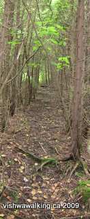
Much of the trail as you get up to the 5th line of Hope Township looks like this: long corridors of mostly cedar .
Vishwawalking
Ganaraska Hiking Trail
Start:
Port Hope to Tinkerville Road (Garden Hill)
Ganaraska Hiking Trail
Start:
Port Hope to Tinkerville Road (Garden Hill)
1)
Beginning of the trail: Port Hope town hall to Sylvan Glen
Total: 7 kilometres
Highway #401 to Sylvan Glen: 4.2
Highway #401 to Sylvan Glen, unofficial route (in red box): 5.3
Running total (official route): 6 kilometres
The trail begins in the Rotary park across from the town hall on Queen Street, which runs south from Walton (the main street).
Port Hope is a great little town, now quite upscale compared to the working-class town it was in the 50s and 60s and before. However, it's always had a part of town where there are grand brick houses and plenty of money. Walk around town to check out some of the historical sites and residential streets. Try Dorset Street West; it's got a steep hill and some fine houses on it.
 The tourist centre next to the Capitol
Theatre has brochures outlining a walking tour you can take. The Capital Theatre
is something to see too. It's one of only two "atmospheric" theatres
surviving in Canada. (There was one in Cornwall, but a developer
purposefully vandalized it in the late 1980s, stealing and destroying
walls and furniture. It's now offices for some god-awful modern junk.
He's probably got an award from the city for his community work. So,
three huzzahs for the volunteers who keep the Capital afloat.) Have a
look at this super-touristy video about Port
Hope to get an overview of the town. (Sorry, the video sucks, but it does give you an idea of the diversity of the town.)
The tourist centre next to the Capitol
Theatre has brochures outlining a walking tour you can take. The Capital Theatre
is something to see too. It's one of only two "atmospheric" theatres
surviving in Canada. (There was one in Cornwall, but a developer
purposefully vandalized it in the late 1980s, stealing and destroying
walls and furniture. It's now offices for some god-awful modern junk.
He's probably got an award from the city for his community work. So,
three huzzahs for the volunteers who keep the Capital afloat.) Have a
look at this super-touristy video about Port
Hope to get an overview of the town. (Sorry, the video sucks, but it does give you an idea of the diversity of the town.)
In non-covid times, the Float Your Fanny Down the Ganny is a fantastic and crazy festival held every (normal) year.
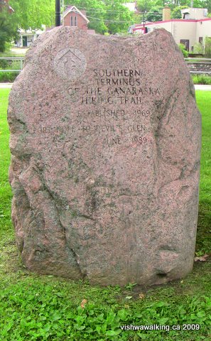
So you've checked out the town. Now for the trail. It officially starts at a red granite rock (the trail guide book calls it "cairn" but there's only one rock) which has some faded words on it referring to the trail.
The pink granite rock at the start of the trail on the
west bank of the Ganaraska River, opposite
the town hall on Queen Street.
Follow the path on the west bank of the river north past the old buildings on the opposite side of the Ganaraska River, now refurbished into classy restaurants and the like. You'll cross the main street, Walton and be treated to the backsides of main street shops for a short while (including the LCBO, if you need any crucial supplies). Notice the Ganaraska Hotel, once a dive, now a decent place to get a beer.
 When you get to Barrett Street, turn
right over the walk bridge just north of the road, then left
along the opposite bank of the river. There's a little park here that
peters out, but the trail continues clearly. There are trail markings,
but you don't really need them as the path is apparent. You'll find a
few mini-log bridges and boardwalks that will get you over some dips
and wet spots, but you are walking in areas that do sometimes get wet
depending upon the year.. In late June, there was no
serious problem with damp spots.
When you get to Barrett Street, turn
right over the walk bridge just north of the road, then left
along the opposite bank of the river. There's a little park here that
peters out, but the trail continues clearly. There are trail markings,
but you don't really need them as the path is apparent. You'll find a
few mini-log bridges and boardwalks that will get you over some dips
and wet spots, but you are walking in areas that do sometimes get wet
depending upon the year.. In late June, there was no
serious problem with damp spots.
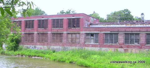 Roughly
300 metres from Barrett Street, you'll see the old abandoned Nicholson
file factory across the river. The building was
built in 1853 and despite its decrepitude has some industrial charm.
Roughly
300 metres from Barrett Street, you'll see the old abandoned Nicholson
file factory across the river. The building was
built in 1853 and despite its decrepitude has some industrial charm.
Watch out for poison ivy along the trail, and some stinging nettles too. Neither are a bother if you're aware of them as the trail winds pleasantly along, close to the river.
The old Nicholson File factory on Cavan Street, viewed from the trail
across the river.
North of the Nicholson File factory, the trail winds through some large cement abutments for what was known as the "Old Iron Bridge." These markers are all that remain of the bridge today. When the Ganaraska Trail was being developed in the late 1960s, the ties had already been removed from this bridge, creating one more difficulty for the original trail blazers who wanted to use the old rail bed. (Private landowner difficulties was the other major trail block.)
At the bridge (Jocelyn/Molson streets) you could be convinced to follow the path under the bridge. It's a nice side trip, but you can't get back to the trail without fording the river. Therefore, you'll have to climb up the bridge embankment to Jocelyn Street and walk across the bridge to Cavan street, where you'll turn left. Walk past the Grace Evangelical Missionary Church's building, which is, I'm sure, very efficient, but an extremely uninspiring building.
More inspiring is the "fishway" at Corbett's dam, just before the road runs under the 401 highway. It's a fish run that was built in 1973 to help salmon make their way upriver to their spawning grounds. You can't really see the run as it's in a 90-foot tunnel, but it's made up of nine pools, each one a foot higher than the one before. Fish jump up to a pool and take a rest before tackling the next one. You can see the need for the run when you get a look at the dam itself: it's a sheer drop made up of concrete and water. I believe that fish actually did attempt the dam before there was a fish run (and some succeeded) but the effort took its toll and even those that made it were exhausted from the effort.
 According to conservation authorities, the best
time to
view the salmon running the river is in September, although the fish
run from mid-August to early October.
According to conservation authorities, the best
time to
view the salmon running the river is in September, although the fish
run from mid-August to early October.
From the fishway, the road curves under the #401, past the Port Hope Conservation Area and northwest up Choate Road. (Some maps note McKibbon Street here. I not sure if that's an old name, or a map error.)
Unfortunately, the original trail, which followed parts of the abandoned rail line of the Port Hope Lindsay and Beaverton Railway, has had to be bypassed because of private property issues.
The description in the box below outlines a route closer to the original trail, but there are serious caveats you should consider before trying this. It is, however, a much more satisfying route. The official route continues below the box.
At the Port Hope Conservation Area, turn right up Choate Road. The road climbs past a residential area to a fine view of the country. From the top of Choate Road, you'll have rolling fields on both sides all the way, punctuated with a few houses and barns.
 At
1.5 kilometres from the conservation area, take a right down Hawkins
Road. This is a narrow gravel road that runs just under a kilometre to
to the larger Dale Road, where you'll turn left and walk less than half
a kilometre to Sylvan Glen Road.
At
1.5 kilometres from the conservation area, take a right down Hawkins
Road. This is a narrow gravel road that runs just under a kilometre to
to the larger Dale Road, where you'll turn left and walk less than half
a kilometre to Sylvan Glen Road.
Road sections — Easy, except for some sections along
the river, which are easy-moderate.
Total: 10 kilometres
Running total: 17 kilometres
Here's some confusing stuff: Standing on Sylvan Glen Road, it is clear that the trail heads off into the bushes to the left (west). However, on the trail's official website, there is a reroute showing the trail as continuing north on Sylvan Glen Road. These reroutes, so the website says, are to be used if you have the pre-2006 guide book. However, the 2006 guide book shows the woods route, not the Sylvan Glen route. Huh?
The road route is boring, so here's the solution: ignore the (possible) website reroute and follow the signs that take you along the river to the left.
Warning: when the trail reaches the 4th line, the confusion is not over. See below.
By the way, many sections of the trail to the 7th line are not appropriate for small kids. There is major undergrowth here, so you would be carrying small people much of the time. Also the poison ivy is rampant in sections.
So we're heading off to the left just after the bridge, through a mature cedar forest with a rich floor of ferns. I kept thinking this forest would make a great setting for some medieval romantic fantasy film, with the light shining through the tall trees making all kinds of patterns.
 Although
it was minimal when I walked this section in late July, there is a
potential for the trail to be muddy.
Although
it was minimal when I walked this section in late July, there is a
potential for the trail to be muddy.
There are boardwalks in places to help you through some of the worse spots.
The trail gets close to the river at points and you can see it meandering to the south.
Notice the mud/sand/gravel bars, which indicate just how much this river must shift over time.
As a bow in the river heads it more westerly, a little creek flows into it from the north and the trail follows that for a short while. About 700 metres from the road, a little wooden bridge crosses the creek and you'll find yourself in an open grassy area. It looks like it may have been an old field or perhaps a fruit orchard. There are a few apple trees along the way.
The trail then returns to cedar forest and winds along then up a hill, getting the 4th line in just over a kilometre from Sylvan Glen.
Head right along the road, past Sylvan Glen then Barrie roads (running off to the right and left respectively). Then after just over a kilometre on the road, you'll come to Knoxville Road.
More confusion: there are trail markers indicating the trail heads north up Knoxville Road. Markers also continue along the 4th line. I will assume that the latter is the main trail as it's much more interesting. However, the Knoxville route may be a rerouting. There's no information on the website to indicate what's up.
If you decide to take the Knoxville route, it's 2.3 kilometres from the 4th line to the 5th line. The route is uphill for much pf the way. The best bits are at the north end, when the road winds about with well-kept interesting houses on either side.
 From
the Knoxville Road and 4th Line junction, it's 3.4 kilometres
if
you continue east along the 4th and cut up onto the rail bed. Walk the
straight (and rather boring) 4th line under the power lines and past an
open area on your left and a farm on your right. The trail turns right
at the 1.2-kilometre from Knoxville Road point and heads up to a flat
grassy alleyway that is the rail bed.
From
the Knoxville Road and 4th Line junction, it's 3.4 kilometres
if
you continue east along the 4th and cut up onto the rail bed. Walk the
straight (and rather boring) 4th line under the power lines and past an
open area on your left and a farm on your right. The trail turns right
at the 1.2-kilometre from Knoxville Road point and heads up to a flat
grassy alleyway that is the rail bed.
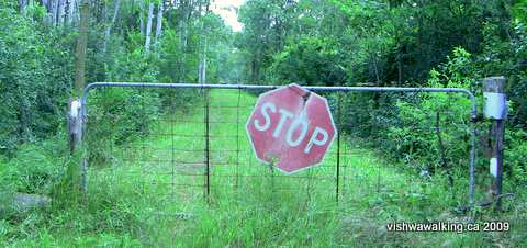
The gate at the 4th line where the trail turns north. Notice the wide grassy rail
bed. Also, theres a piece of plastic on the right-hand post. It may have had a
message on it but it's blank now. There's a similar one at the 5th line, covering
a trail marker.
(By the way, I parked my bicycle on the 4th line, locking it to a metal signpost, thinking I might use it for the journey back to my car. As I walked the 4th line, a big grey 8-cylinder car with four young guys in it roared past. In the distance, I noticed its backup lights go on. I headed up onto the rail bed, but the taillights issue bugged me, so I returned and hid behind a bush where I could see my bike. Sure enough, the car returned and a guy got out and inspected my bike, tugging and rattling the lock. As he returned to the car, I stepped out and made it clear I had clocked their licence plate as they drove off.
I tend to be paranoid about bicycle theft in the city and more cavalier in the country. It's a prejudice I should get over. There are scumbag bicycle thieves in the country too. I re-stashed my bike deep in the woods. Turns out I didn't use it anyway.)
Step around the gate on the left side and head down the grassy lane. This turns into a double-tracked dirt/grass lane, running through a cedar forest. The trail bed runs high here, giving you a good view of the forest.
 The
rail bed ends abruptly and the trail turns to the right down a steep
hill to a little creek. Some cedar trunks are conveniently placed to
help you over and a rope is strung across to aid you.
The
rail bed ends abruptly and the trail turns to the right down a steep
hill to a little creek. Some cedar trunks are conveniently placed to
help you over and a rope is strung across to aid you.
A little careful stepping will get you across with dry feet. Turn to the right and follow the creek north. The rail bed is washed out here and the path runs high but narrows considerably, with the creek on your right.
Eventually the trail settles down a bit, running in a slow curve over to the Knoxville and 5th Line junction. There's a power line shortly after the creek according to my map, but I missed it entirely as I concentrated on avoiding poison ivy. The trail runs low in a corridor of cedars now, often with banks on either side that prevent you from seeing too far. It was minimally muddy in late July; I'm not sure what it would be like in the spring.
The trail comes out onto Knoxville Road, just below the 5th line. Walk up to the 5th and turn left. Almost immediately you will be plunged back onto the rail bed.
The high grass at the road's edge belies the more open stretch not far in. However, this next section up to Hope Township's 7th line is a real mixed bag of wide trail interspersed with overgrown trail. Poison ivy lurks at every turn.
 After the roadside grass (and a bit of poison
ivy lurking below it) the trail opens into a narrow corridor.
After the roadside grass (and a bit of poison
ivy lurking below it) the trail opens into a narrow corridor.
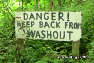
It was obvious no one had done this piece for a while. Just before a washout in the rail bed, vines matted the trail.
At the washout, there is a huge sign. Head to the right, down some rudimentary stairs, over the creek and up the steep set of stairs made of old railway ties.
Sign at the washout north of Hope Township's
5th Line.
Once up onto the rail bed again, the trail opens onto a mown area, but not before you have to negotiate yet another mega-growth of poison ivy. It's impossible to avoid it, especially as you come down from the rail bed onto the mown area.
This mown area is connected by a little side trail to a house off to the right. However, we will head straight on.
(If you're walking this section south, make sure you don't curve left from this mown area and follow the mown trail right. It leads to the back yard of a house.)
The mown section narrows as the trail heads north and the rail bed still rides high. As it levels out the underbrush gets thick. The trail crosses a driveway that runs off the north-south Heaslip Lane, which runs close by on the left at this point. Then the trail runs through a gully with sides that don't allow you to see much more than the cedar corridor you are following. It's also wet, so I suspect this section could be very wet in the spring.
At the power lines the rough trail cleans up. Vehicles have used this section and its likely the trail is used by power company trucks coming south from the 6th line. The open double track is welcome after the rough trail that has come before.
The 6th line is quite a rough road at the point where it meets the trail. It is possible to drive a car through (at least in the summer), but you might want to pass on this if you don't like rough roads. There's a particularly rough hill to the west. Except for this short section, the 6th is a well-maintained road.
The trail goes back to long undergrowth north of the 6th. After crossing a style, you'll be picking your way through grass, vines and the ever-present poison ivy. You'll have to coordinate the sometimes faint path with the infrequent trail markers here.
And then, as the trail opens into an old field, you will come upon an east-west mown trail, and the rail bed (which continues north) is also mown.
(If you're travelling this route south, this part can confuse you: you're travelling happily on the rail bed on a clear mown path, which then comes to a "T" intersection. Don't be lured into going east or west; the trail south is straight ahead into the long grass.)
As the mown path winds along the rail bed, a pond will appear on your left, with a house on the far side. Continue as the rail bed rides high on the east side of the pond. About halfway along the east side of the pond, a little stream runs east from the pond and you'll drop down a steep hill to a little bridge. Once over the bridge, you'll see a mown path running off to the right. However, the trail heads left up the opposite embankment, back to the rail bed.
You should pause to take a detour here. The mown path to the right leads to a little pond with a picnic table beside it. Beautiful little mown trails branch off into the meadows and a wood to the east, running through both grassy areas and by the stream which runs through a cedar wood. The trails in the cedar wood are harder to follow, but the mown trails are easy and fun. If you wander about a bit, you can make a loop from the bridge, around the little pond, and through the fields back to the trail farther south. Or, you can simply circle the little pond back to the bridge.
The mown trail continues on the rail bed. Then, if you're not ready for it, the house and back garden the trail bed opens onto can take you by surprise. It runs over the back lawn, by the house and down the drive. No one was home when I walked this section, but I did look about a bit first to see if I'd got it wrong and there was a circuit around the house. Nope. This is the trail.
Full points to the enlightened landowners who allow this.
At Campbell Road turn right (north) up the hill.
After 1.4 kilometres on Campbell Road, you'll turn left onto the 7th line.
Rating: This
section is a mixed bag. There are some beautiful sections here, especially close to the river, but
overall the thick undergrowth and the on-trail prevalence of poison ivy
downgrades this section for me. The road sections are easy and the rolling Northumberland farmland is easy on the eye. The trail sections are moderate.
How to get there: Port Hope is on the Highway #401 corridor along the north shore of Lake Ontario. It's 90 kilometres from the #401 and Don Valley Junction in Toronto. Coming from the west, take the first Port Hope exit (Welcome, County Road #2 and Toronto Road) and head south 2.5 kilometres on the Toronto Road to Rideout Street. Turn left onto Rideout, which will turn into Walton street, the main drag. Another 1.2 kilometres will get you to Queen Street (near the bottom of the town, but before you cross the Ganaraska River). Turn right here and in less than 250 metres, after the library on your left and a little park on the right you'll see the town hall on your right. You can park behind the town hall for free.
From the east: Take the first Port Hope exit and head south on County Road 28 (you'll cross over #401 shortly after you get off the highway). At the 2 kilometre point, the main road curves and turns into Mill Street. However, stick with Ontario which is roughly straight ahead and to the right. Something slightly short of half a kilometre will get you to a "T" intersection. You are now downtown; turn left and you're on Walton Street. Take the next right and you'll see the town hall on your right in less than 250 metres.
Total: 7 kilometres
Highway #401 to Sylvan Glen: 4.2
Highway #401 to Sylvan Glen, unofficial route (in red box): 5.3
Running total (official route): 6 kilometres
The trail begins in the Rotary park across from the town hall on Queen Street, which runs south from Walton (the main street).
Port Hope is a great little town, now quite upscale compared to the working-class town it was in the 50s and 60s and before. However, it's always had a part of town where there are grand brick houses and plenty of money. Walk around town to check out some of the historical sites and residential streets. Try Dorset Street West; it's got a steep hill and some fine houses on it.
The tourist centre next to the Capitol
Theatre has brochures outlining a walking tour you can take. The Capital Theatre
is something to see too. It's one of only two "atmospheric" theatres
surviving in Canada. (There was one in Cornwall, but a developer
purposefully vandalized it in the late 1980s, stealing and destroying
walls and furniture. It's now offices for some god-awful modern junk.
He's probably got an award from the city for his community work. So,
three huzzahs for the volunteers who keep the Capital afloat.) Have a
look at this super-touristy video about Port
Hope to get an overview of the town. (Sorry, the video sucks, but it does give you an idea of the diversity of the town.)In non-covid times, the Float Your Fanny Down the Ganny is a fantastic and crazy festival held every (normal) year.
So you've checked out the town. Now for the trail. It officially starts at a red granite rock (the trail guide book calls it "cairn" but there's only one rock) which has some faded words on it referring to the trail.
The pink granite rock at the start of the trail on the
west bank of the Ganaraska River, opposite
the town hall on Queen Street.
Follow the path on the west bank of the river north past the old buildings on the opposite side of the Ganaraska River, now refurbished into classy restaurants and the like. You'll cross the main street, Walton and be treated to the backsides of main street shops for a short while (including the LCBO, if you need any crucial supplies). Notice the Ganaraska Hotel, once a dive, now a decent place to get a beer.
When you get to Barrett Street, turn
right over the walk bridge just north of the road, then left
along the opposite bank of the river. There's a little park here that
peters out, but the trail continues clearly. There are trail markings,
but you don't really need them as the path is apparent. You'll find a
few mini-log bridges and boardwalks that will get you over some dips
and wet spots, but you are walking in areas that do sometimes get wet
depending upon the year.. In late June, there was no
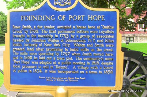
serious problem with damp spots.A very short history of early
Port Hope. This sign is outside the town hall.
Roughly
300 metres from Barrett Street, you'll see the old abandoned Nicholson
file factory across the river. The building was
built in 1853 and despite its decrepitude has some industrial charm.Watch out for poison ivy along the trail, and some stinging nettles too. Neither are a bother if you're aware of them as the trail winds pleasantly along, close to the river.
The old Nicholson File factory on Cavan Street, viewed from the trail
across the river.
North of the Nicholson File factory, the trail winds through some large cement abutments for what was known as the "Old Iron Bridge." These markers are all that remain of the bridge today. When the Ganaraska Trail was being developed in the late 1960s, the ties had already been removed from this bridge, creating one more difficulty for the original trail blazers who wanted to use the old rail bed. (Private landowner difficulties was the other major trail block.)
At the bridge (Jocelyn/Molson streets) you could be convinced to follow the path under the bridge. It's a nice side trip, but you can't get back to the trail without fording the river. Therefore, you'll have to climb up the bridge embankment to Jocelyn Street and walk across the bridge to Cavan street, where you'll turn left. Walk past the Grace Evangelical Missionary Church's building, which is, I'm sure, very efficient, but an extremely uninspiring building.
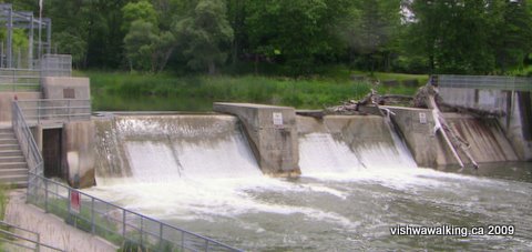
More inspiring is the "fishway" at Corbett's dam, just before the road runs under the 401 highway. It's a fish run that was built in 1973 to help salmon make their way upriver to their spawning grounds. You can't really see the run as it's in a 90-foot tunnel, but it's made up of nine pools, each one a foot higher than the one before. Fish jump up to a pool and take a rest before tackling the next one. You can see the need for the run when you get a look at the dam itself: it's a sheer drop made up of concrete and water. I believe that fish actually did attempt the dam before there was a fish run (and some succeeded) but the effort took its toll and even those that made it were exhausted from the effort.
According to conservation authorities, the best
time to
view the salmon running the river is in September, although the fish
run from mid-August to early October.From the fishway, the road curves under the #401, past the Port Hope Conservation Area and northwest up Choate Road. (Some maps note McKibbon Street here. I not sure if that's an old name, or a map error.)
The dam that
required a fish ladder to be built in 1973 to help salmon get to their
spawning grounds. The ladder starts at the opening just to the right of the
stairs on the left side of the photo.
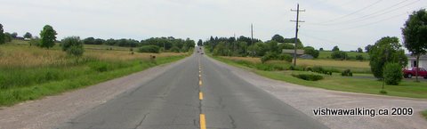
The
next section is pretty mundane, running along paved and gravel roads.
The best part of this section is at the top of the hill on Choate Road,
where you get a good view of the rolling hills to the north. Some of
them are drumlins, which the guide book describes as "elongated,
oval-shaped mounds of glacial till that were deposited and shaped
beneath an advancing sheet during the last ice age" (2006, p. 6).spawning grounds. The ladder starts at the opening just to the right of the
stairs on the left side of the photo.
Unfortunately, the original trail, which followed parts of the abandoned rail line of the Port Hope Lindsay and Beaverton Railway, has had to be bypassed because of private property issues.
The description in the box below outlines a route closer to the original trail, but there are serious caveats you should consider before trying this. It is, however, a much more satisfying route. The official route continues below the box.
| The "unofficial"
trail north of Highway #401 from the Port Hope Conservation Area to
Sylvan Glen This section starts just at the Port Hope Conservation Area, just as Choate Road curves westward up the hill. While the early section belongs to conservation authorities, the sections north of that are private. The people who own Thorney Farm's Ganaraska Sugar Camp own the land north of the authority's property up to Dale Road. I met the owner as I was exiting his property. He was very pleasant but told me that they don't allow people to walk on their property — even if you ask. He said that some years ago some young people who were partying and littering on the property were told to leave. They returned and cut his maple syrup lines, costing him thousands of dollars. The Ganaraska Trail authorities, he said, never asked him for permission to cross his property. Add all this up, and you have a property owner not too happy to see people walking his land. I looked, he acknowledged, "pretty harmless" and we left on good terms. However, the message was clear: he didn't like walkers on his property under any circumstances. The landowner north of the Dale Road, he said, was more tolerant. If I walked along the edge of his/her cornfield, I'd be okay. You have been warned. This section is very pleasant and, as mentioned preferable to the official route. I grew up in this area and can remember coming here to the river to play. The water is very shallow in spots, so it's a natural attraction for any kid with a little Huck Finn in them. The trail heads north through two iron gates on a short grassy stretch, then quickly narrows to a single path. There are all sorts of side trail to the river. The undergrowth is dense and the river bank drops a few feet, making it hard to actually get to water in places. The trail is clear, sometimes opening to a double track and sometimes cutting through high grass. When there are side trails, always keep the river in mind, staying reasonably close to it. I tried actually walking the riverbank, but the underbrush makes that a serious proposition. However, you'd miss a big part of this walk if you didn't follow a few of the trails to the riverbank and watch the river as it winds south. 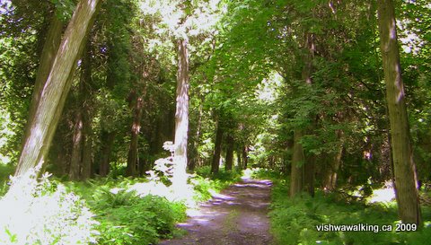 There
are spots where the ferns stretch for quite a while. At other places,
you can see the flat river bed extending beyond the banks. I imagine
this creates a number of ponds in the spring. In July, the flatlands
are largely high grass. There
are spots where the ferns stretch for quite a while. At other places,
you can see the flat river bed extending beyond the banks. I imagine
this creates a number of ponds in the spring. In July, the flatlands
are largely high grass. At the south end, the river is generally pretty placid, with wide flat sections. As you get north, there are high banks slowly eroding as the river carves a new path. An impressive stand of large cedars along one of the more established section of the trail 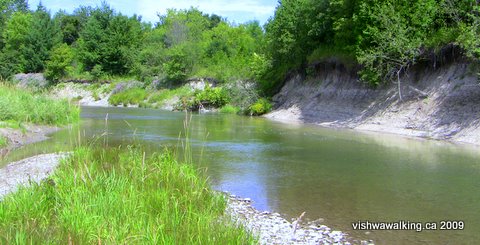 Little
gravel "islands" sit in the river bed and at several places, the water
gently ripples over shallow gravel. There are no rapids to speak of. Little
gravel "islands" sit in the river bed and at several places, the water
gently ripples over shallow gravel. There are no rapids to speak of.There are maple stands along the way and at one point a quite majestic stand of cedars in a section of the trail that looks like it's used by small vehicles (see photo above). Most of the trail is not this open or wide. The view from a gravel "island"
in the river south of Dale Road. Notice the east
bank slowly eroding. At times you can clearly see the old rail bed that once ran beside the Ganaraska. (See the Port Hope Lindsay and Beaverton Railway entry in my Rails to Trails section for more history of this rail line. We'll run into this rail bed further north.) At others, the trail wanders through high grass and neither rail bed nor trail is clearly established — but it's always clear enough to follow. If you're walking after a rainfall, bring appropriate clothes, as you'll be brushing the undergrowth a lot. At the Dale Road bridge, the track curves to the west and runs along the south bank of Dale Road for a short stretch before coming out at a processing station of Thorney Farm's Ganaraska Sugar Camp. This was a surprise for me. I immediately moved over the fence to the highway, where shortly afterwards I had my conversation with the owner. If I had known I was coming so close to the maple syrup operations, I would have bushwhacked my way to the highway closer to the bridge (not to avoid the owner so much as to stay clear of his business operations). I'm not sure what the situation is here, but I'm sure there's a reasonable way to make your way through to the bridge without climbing fences.  North
of Dale Road, make your way to the west edge of the corn field. This is
the easiest walking. Closer to the river there is high grass, dense
underbrush and it's sometimes wet. You can walk close to the brush at
the edge of the field, staying well clear of the corn. North
of Dale Road, make your way to the west edge of the corn field. This is
the easiest walking. Closer to the river there is high grass, dense
underbrush and it's sometimes wet. You can walk close to the brush at
the edge of the field, staying well clear of the corn.When the cornfield curves west at one point, flip over to the next cornfield, following the river. There's a field just north of the power lines, but move on north to the next corn field. This view is from a high ridge on the edge of a corn field north of Dale Road. Behind are rolling fields of corn. Below the ridge, the river winds through a valley. Here the field runs high on a ridge that drops down into a wide valley cut by the river. At the end of this corn field, turn right onto the road. This road is an extension of Hawkins Road (see the main trail description for more on this road). The road soon ends, but follow the track along the power lines to the river. The field to the left is an active pasture for cattle, so give it as wide a berth as possible. I saw a majestic cow with horns grazing with other cows and steers. There is an electric fence keeping the cows out of the river (Hurrah! — major points for the farmer) that you can move around to stay clear of the cattle. (The cattle saw me as I walked down the power line and immediately moved away, so this should not be a problem.) As the track extending Hawkins Road reaches the river, it rides high on a man-made ridge. You can see the cement remains from an old bridge that once crossed the river here. Follow the river as best you can. I found it necessary to cross the electric wire eventually; the river banks were too steep and I wanted to keep my feet dry. I walked close to the fence just in case, but there were no cattle in sight. You can climb over the electric fence without touching it. I did not check to see if it was live. I've inadvertently touched an electric fence before and it sent me flat on my backside. I walked with a definite unpleasant buzz going through my body for quite some time after. If you're equipped and adventurous, I imagine you could wade most of this section of the river. You will have to negotiate the electric fence a couple of times, but there are plenty of places where it is easy to step over.As you close in to the bridge near Sylvan Glen, you can push through a bit of underbrush and climb to the road without crossing any fences. You are now back on the official trail. Rating: Walked: July 15, 2009 |
At the Port Hope Conservation Area, turn right up Choate Road. The road climbs past a residential area to a fine view of the country. From the top of Choate Road, you'll have rolling fields on both sides all the way, punctuated with a few houses and barns.
At
1.5 kilometres from the conservation area, take a right down Hawkins
Road. This is a narrow gravel road that runs just under a kilometre to
to the larger Dale Road, where you'll turn left and walk less than half
a kilometre to Sylvan Glen Road. Looking west down Dale Road from
Hawkins Road. That's Hawkins Road also
extending north to the right in this photo. If you took the "alternate"route
(in the red box), you'll connect to the riverside end of this road.
Turn right (north) at Sylvan Glen Road and walk 1.3 kilometres to Sylvan Glen. Just over the bridge, you'll see the trail marker pointing you left into the woods.
Rating:
Town and the walk along the river to Jocelyn Street — extending north to the right in this photo. If you took the "alternate"route
(in the red box), you'll connect to the riverside end of this road.
Turn right (north) at Sylvan Glen Road and walk 1.3 kilometres to Sylvan Glen. Just over the bridge, you'll see the trail marker pointing you left into the woods.
Road sections — Easy, except for some sections along
the river, which are easy-moderate.Walked: June 30, July 15, 2009
2)
Sylvan Glen to Hope Township 7th Line.Total: 10 kilometres
Running total: 17 kilometres
Here's some confusing stuff: Standing on Sylvan Glen Road, it is clear that the trail heads off into the bushes to the left (west). However, on the trail's official website, there is a reroute showing the trail as continuing north on Sylvan Glen Road. These reroutes, so the website says, are to be used if you have the pre-2006 guide book. However, the 2006 guide book shows the woods route, not the Sylvan Glen route. Huh?
The road route is boring, so here's the solution: ignore the (possible) website reroute and follow the signs that take you along the river to the left.
Warning: when the trail reaches the 4th line, the confusion is not over. See below.
By the way, many sections of the trail to the 7th line are not appropriate for small kids. There is major undergrowth here, so you would be carrying small people much of the time. Also the poison ivy is rampant in sections.
So we're heading off to the left just after the bridge, through a mature cedar forest with a rich floor of ferns. I kept thinking this forest would make a great setting for some medieval romantic fantasy film, with the light shining through the tall trees making all kinds of patterns.
Although
it was minimal when I walked this section in late July, there is a
potential for the trail to be muddy.There are boardwalks in places to help you through some of the worse spots.
The trail gets close to the river at points and you can see it meandering to the south.
Notice the mud/sand/gravel bars, which indicate just how much this river must shift over time.
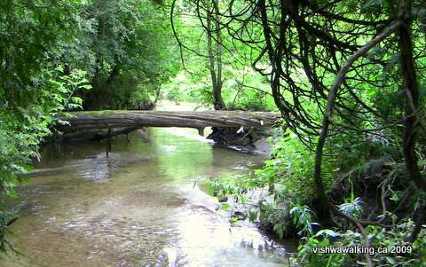
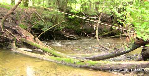
The trail follows this little
north-south creek for a while before it crosses it a little
farther north. That's the Ganaraska in the distance beyond the log.
farther north. That's the Ganaraska in the distance beyond the log.
As a bow in the river heads it more westerly, a little creek flows into it from the north and the trail follows that for a short while. About 700 metres from the road, a little wooden bridge crosses the creek and you'll find yourself in an open grassy area. It looks like it may have been an old field or perhaps a fruit orchard. There are a few apple trees along the way.
The trail then returns to cedar forest and winds along then up a hill, getting the 4th line in just over a kilometre from Sylvan Glen.
Head right along the road, past Sylvan Glen then Barrie roads (running off to the right and left respectively). Then after just over a kilometre on the road, you'll come to Knoxville Road.
More confusion: there are trail markers indicating the trail heads north up Knoxville Road. Markers also continue along the 4th line. I will assume that the latter is the main trail as it's much more interesting. However, the Knoxville route may be a rerouting. There's no information on the website to indicate what's up.
If you decide to take the Knoxville route, it's 2.3 kilometres from the 4th line to the 5th line. The route is uphill for much pf the way. The best bits are at the north end, when the road winds about with well-kept interesting houses on either side.
From
the Knoxville Road and 4th Line junction, it's 3.4 kilometres
if
you continue east along the 4th and cut up onto the rail bed. Walk the
straight (and rather boring) 4th line under the power lines and past an
open area on your left and a farm on your right. The trail turns right
at the 1.2-kilometre from Knoxville Road point and heads up to a flat
grassy alleyway that is the rail bed.The gate at the 4th line where the trail turns north. Notice the wide grassy rail
bed. Also, theres a piece of plastic on the right-hand post. It may have had a
message on it but it's blank now. There's a similar one at the 5th line, covering
a trail marker.
(By the way, I parked my bicycle on the 4th line, locking it to a metal signpost, thinking I might use it for the journey back to my car. As I walked the 4th line, a big grey 8-cylinder car with four young guys in it roared past. In the distance, I noticed its backup lights go on. I headed up onto the rail bed, but the taillights issue bugged me, so I returned and hid behind a bush where I could see my bike. Sure enough, the car returned and a guy got out and inspected my bike, tugging and rattling the lock. As he returned to the car, I stepped out and made it clear I had clocked their licence plate as they drove off.
I tend to be paranoid about bicycle theft in the city and more cavalier in the country. It's a prejudice I should get over. There are scumbag bicycle thieves in the country too. I re-stashed my bike deep in the woods. Turns out I didn't use it anyway.)
Step around the gate on the left side and head down the grassy lane. This turns into a double-tracked dirt/grass lane, running through a cedar forest. The trail bed runs high here, giving you a good view of the forest.
The
rail bed ends abruptly and the trail turns to the right down a steep
hill to a little creek. Some cedar trunks are conveniently placed to
help you over and a rope is strung across to aid you.A little careful stepping will get you across with dry feet. Turn to the right and follow the creek north. The rail bed is washed out here and the path runs high but narrows considerably, with the creek on your right.
A little creek must be crossed at
a point where the rail bed ends abruptly. Notice
the rope strung across to help you over the creek.
Unfortunately,
just at the point where you are locked in to this narrow path, the poison ivy
sets in. It's a steep drop on either side, so you have to stay with the
trail. You need to do a delicate dance to minimise contact with the
poison ivy. This problem recurs as we head north.the rope strung across to help you over the creek.
Eventually the trail settles down a bit, running in a slow curve over to the Knoxville and 5th Line junction. There's a power line shortly after the creek according to my map, but I missed it entirely as I concentrated on avoiding poison ivy. The trail runs low in a corridor of cedars now, often with banks on either side that prevent you from seeing too far. It was minimally muddy in late July; I'm not sure what it would be like in the spring.
The trail comes out onto Knoxville Road, just below the 5th line. Walk up to the 5th and turn left. Almost immediately you will be plunged back onto the rail bed.
The high grass at the road's edge belies the more open stretch not far in. However, this next section up to Hope Township's 7th line is a real mixed bag of wide trail interspersed with overgrown trail. Poison ivy lurks at every turn.
After the roadside grass (and a bit of poison
ivy lurking below it) the trail opens into a narrow corridor.It was obvious no one had done this piece for a while. Just before a washout in the rail bed, vines matted the trail.
At the washout, there is a huge sign. Head to the right, down some rudimentary stairs, over the creek and up the steep set of stairs made of old railway ties.
Sign at the washout north of Hope Township's
5th Line.
Once up onto the rail bed again, the trail opens onto a mown area, but not before you have to negotiate yet another mega-growth of poison ivy. It's impossible to avoid it, especially as you come down from the rail bed onto the mown area.
This mown area is connected by a little side trail to a house off to the right. However, we will head straight on.
(If you're walking this section south, make sure you don't curve left from this mown area and follow the mown trail right. It leads to the back yard of a house.)
The mown section narrows as the trail heads north and the rail bed still rides high. As it levels out the underbrush gets thick. The trail crosses a driveway that runs off the north-south Heaslip Lane, which runs close by on the left at this point. Then the trail runs through a gully with sides that don't allow you to see much more than the cedar corridor you are following. It's also wet, so I suspect this section could be very wet in the spring.
At the power lines the rough trail cleans up. Vehicles have used this section and its likely the trail is used by power company trucks coming south from the 6th line. The open double track is welcome after the rough trail that has come before.
The 6th line is quite a rough road at the point where it meets the trail. It is possible to drive a car through (at least in the summer), but you might want to pass on this if you don't like rough roads. There's a particularly rough hill to the west. Except for this short section, the 6th is a well-maintained road.
The trail goes back to long undergrowth north of the 6th. After crossing a style, you'll be picking your way through grass, vines and the ever-present poison ivy. You'll have to coordinate the sometimes faint path with the infrequent trail markers here.
And then, as the trail opens into an old field, you will come upon an east-west mown trail, and the rail bed (which continues north) is also mown.
(If you're travelling this route south, this part can confuse you: you're travelling happily on the rail bed on a clear mown path, which then comes to a "T" intersection. Don't be lured into going east or west; the trail south is straight ahead into the long grass.)
As the mown path winds along the rail bed, a pond will appear on your left, with a house on the far side. Continue as the rail bed rides high on the east side of the pond. About halfway along the east side of the pond, a little stream runs east from the pond and you'll drop down a steep hill to a little bridge. Once over the bridge, you'll see a mown path running off to the right. However, the trail heads left up the opposite embankment, back to the rail bed.
You should pause to take a detour here. The mown path to the right leads to a little pond with a picnic table beside it. Beautiful little mown trails branch off into the meadows and a wood to the east, running through both grassy areas and by the stream which runs through a cedar wood. The trails in the cedar wood are harder to follow, but the mown trails are easy and fun. If you wander about a bit, you can make a loop from the bridge, around the little pond, and through the fields back to the trail farther south. Or, you can simply circle the little pond back to the bridge.
The mown trail continues on the rail bed. Then, if you're not ready for it, the house and back garden the trail bed opens onto can take you by surprise. It runs over the back lawn, by the house and down the drive. No one was home when I walked this section, but I did look about a bit first to see if I'd got it wrong and there was a circuit around the house. Nope. This is the trail.
Full points to the enlightened landowners who allow this.
At Campbell Road turn right (north) up the hill.
A
Side Trail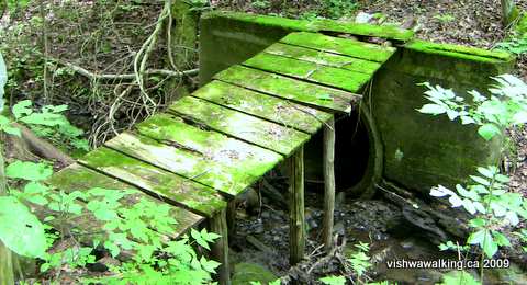 Roughly 400
metres up the hill after you've turned onto Campbell Road, you'll see a
trail heading off to the left. This is
a far preferable trail to the road, and leads back to the rail bed.
It's marked by occasional yellow tape around trees. As you get into the
woods, it's a bit wet, but a fairly long (and pretty basic, but sound)
boardwalk gets you over it easily, until you reach a bridge
that has
been cordoned off with rope. It's getting pretty ancient and
rickety.
Roughly 400
metres up the hill after you've turned onto Campbell Road, you'll see a
trail heading off to the left. This is
a far preferable trail to the road, and leads back to the rail bed.
It's marked by occasional yellow tape around trees. As you get into the
woods, it's a bit wet, but a fairly long (and pretty basic, but sound)
boardwalk gets you over it easily, until you reach a bridge
that has
been cordoned off with rope. It's getting pretty ancient and
rickety.An old bridge leading up to the rail bed on the Campbell Road side trail. You may want to play it safe and get down into the stream bed and jump the stream. It leads up an incline back to the rail bed. The path here (much like a lot of the main trail) can get thick with undergrowth, but it's not too bad. It eventually runs close to the stream (on the left). Watch the path closely here as the rail bed get indistinct. I followed a path up to a mown grassy path beside a field of barley grass. It led me eastward back to Campbell Road. In retrospect, I should have looked more closely for the rail bed. There is a likely point where it could ostensibly come out on the 7th line; this deserves more investigation. The trim eastward mown trail leads to a huge house's back yard and a beautiful lawn. However, this time it's not the official trail, so I tried to dodge the lawn. No one was home, but it seemed too close to be walking to a home without permission. The trouble is, if you dodge into the thickets to the left, you'll soon come out to someone else's finely kept lawn. The house to this second lawn is some distance off, so I slid along the hedgerow and back to the road. I trust the landowners wouldn't mind. It may be a while before I get to it, but I'd like to track down the rest of the rail bed to the 7th line. After that, I fear it disappears into a corn field for a stretch. |
After 1.4 kilometres on Campbell Road, you'll turn left onto the 7th line.
Rating:
This
section is a mixed bag. There are some beautiful sections here, especially close to the river, but
overall the thick undergrowth and the on-trail prevalence of poison ivy
downgrades this section for me. The road sections are easy and the rolling Northumberland farmland is easy on the eye. The trail sections are moderate. Walked: July 27, 28, 2009
How to get there: Port Hope is on the Highway #401 corridor along the north shore of Lake Ontario. It's 90 kilometres from the #401 and Don Valley Junction in Toronto. Coming from the west, take the first Port Hope exit (Welcome, County Road #2 and Toronto Road) and head south 2.5 kilometres on the Toronto Road to Rideout Street. Turn left onto Rideout, which will turn into Walton street, the main drag. Another 1.2 kilometres will get you to Queen Street (near the bottom of the town, but before you cross the Ganaraska River). Turn right here and in less than 250 metres, after the library on your left and a little park on the right you'll see the town hall on your right. You can park behind the town hall for free.
From the east: Take the first Port Hope exit and head south on County Road 28 (you'll cross over #401 shortly after you get off the highway). At the 2 kilometre point, the main road curves and turns into Mill Street. However, stick with Ontario which is roughly straight ahead and to the right. Something slightly short of half a kilometre will get you to a "T" intersection. You are now downtown; turn left and you're on Walton Street. Take the next right and you'll see the town hall on your right in less than 250 metres.
On to the next section: The 7th Line to the Ganaraska Forest Centre
Back to Ganaraska Trail Introduction
Back to Ganaraska Trail Introduction
Home | Contact Us | Site Map
Page
created: July 3, 2009
Updated: April 15, 2021
Updated: April 15, 2021