About Us
Vishwawalking explained
 Ratings Explained
Vishwawalks
Day walks
Funky Places
Future walks
Food
Gear
Get Lost
Good reads
Links
Right to Ramble
Site map
Contact us

David Crombie, Toronto's "tiny perfect mayor" was an early proponent of a waterfront trail.
Vishwawalking
The Great Lakes Waterfront Trail
 The Waterfront Trail moves
along Lake Ontario and Lake Erie's northern shores. It takes
in interesting little towns, villages and beaches as well as Oshawa,
Toronto, Hamilton and Niagara-on-the-Lake.
The Waterfront Trail moves
along Lake Ontario and Lake Erie's northern shores. It takes
in interesting little towns, villages and beaches as well as Oshawa,
Toronto, Hamilton and Niagara-on-the-Lake.
Some of the trail is along minor highways with fast-moving cars. I have used the official trail when it's interesting and some of the designated roads when I have no choice.
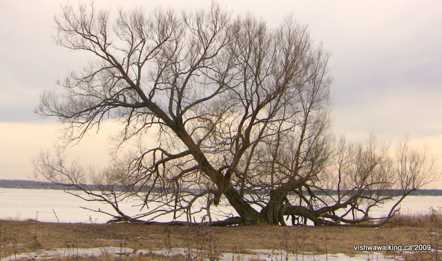
Old oak tree on Lake Ontario, just west of the marsh that is west of Bluff Point;
Telegraph Narrows is in the background. March 3, 2009
I have also taken alternate routes when they looked more attractive, so I suppose this is the "unofficial" route.
I live near the section that is most undeveloped, with the official trail simply linking more interesting areas. Sections of the trail in Trenton Have been vastly improved in the past few years (I write this in 2021). When I first walked this "trail" this some sections were no more more than signs on busy highways. The section between Belleville and Trenton has received little support locally to date and there isn't really an official section in the Tyendinaga Mohawk Territory, despite blue lines on maps and a few signs. Altogether, putting a sign by a highway is pretty useless and uncreative.
Therefore, as vishwawalkers, we sometimes have to take things into our own hands. In my notes, I have tried to note the official route and the route I have chosen. It will be clear when I deviate from the route outlined on the map.
Standing on private land looking out upon a section of the Bay of Quinte, the usual buoyancy I have at the joy of just being out walking can be suddenly replaced by a sadness on sections of the waterfront: it is unlikely that I will ever walk certain sections again. Some of the shoreline is difficult to get to and very occasionally landowners, when they are around, are less than friendly. At these moments, I drink in the view, thinking "this will be the last time I get this particular perspective." It's different than enjoying a view when you're thousands of miles from home and unlikely to be able to visit again. Here, the locale is not far from my home geographically.
But
the land is filling up and I've had my
fill of castle-like houses crushing the view and cutting off choice
pieces of land from public enjoyment.

The Waterfront Trail site is a good one, with clear maps. The Waterfront Regeneration Trust has an onerous job and I laud them for it. Any criticism of actual routes is simply that, not of the fine work being done by hard-working and committed environmentalists.
The creation of the trail
In the early 1980s (and presumably before), there was a concern that large sections of the waterfront in Toronto were being swallowed by private land. In addition, federal lands were being developed, cutting off the waterfront from the city itself and its enjoyment by the people.When I lived in Toronto in the seventies and eighties, there were places you could go to enjoy the lake: the islands, Ontario Place, and a few places farther out. However, both public and private land development was making it hard to get near the water. It's a problem that still exists along the entire waterfront, as you'll see me complain at numerous points along the trail. Another problem is extensive shoreline alteration, particularly "lakefill" — filling in lakeshore to get more shoreline or to alter it to benefit one development or another. This practice is both aesthetically and environmentally destructive.
In 1988, the federal government established the Royal Commission on the Future of the Toronto Waterfront, with David Crombie ( former mayor of the city) as its first commissioner. The commission produced a report called "Regeneration" which contained a recipe to "regenerate' and protect the waterfront. Since that time, the face of the waterfront has drastically altered for the better.
Back in the 17th century and before, the original inhabitants of the lake did little to alter it. But as the industrial era proceeded, more an more projects were undertaken. As early as 1830 "stonehookers" removed as much as 47,000 tons of stone annually from just offshore of the lake, to provide ballast for unburdened sailboats. The removal accelerated shore erosion to such an extent that farmers, seeing the loss of their land, successfully pressured the government to institute the "three-rod law" in 1857, which made it illegal to gather rocks within 15 metres of the shore. But the damage was already done. Other development projects over the years show a similar pattern: destruction followed by attempts to slow or stop the destructions. Unregulated activity followed by regulation, but "only when the damage became serious were limits set, a reaction that effectively 'closed the door after the horse had escaped.'" (Regeneration, p. 151-152). This still goes on, depending upon the government in power.
"Flying over the western shoreline of lake Ontario, one is struck by the intensity of development," notes the "Regeneration" study (p. 152). From industrial development in Hamilton to Toronto's recreational lakefill project, Ontario Place, to endless breakwaters that protect boats and land from the lake's waves, the original lakeshore was destroyed.
One of the commission's proposals were "greenways" along the shores of the lake that would both protect what was left of the natural shoreline and provide a recreational space that everyone could enjoy. The commission used earlier studies to bolster its position. One of those was a provincial study made in 1991 called The Waterfront Trail: First Steps from Concept to Reality (Reid et al., 1991). In the same year, a Citizens for a Lakeshore Greenway (CFLAG) was created. As the report "Regeneration" describes, the word "greenways" describes environmental friendly and publicly accessible areas that connect "wildlife habitats to each other, human communities to other human communities, city to country, people to nature" (p. 179).
As a result of the commission's report, the Waterfront Regeneration Trust was formed in 1992. It immediately set about working to mitigate environmental damage created by such developments as highways and gravel pits near the waterfront. It also worked with communities and public and private landowners to develop the waterfront trail. In 1995, it opened a "virtually continuous" trail from Stoney Creek to Trenton. Since then, it has more than doubled the length of the trail to create a continuous trail from Niagara-on-the-Lake to Brockville and farther. A possibly old page on the trail's site envisions an eventual link up with the Great Lakes Seaway Trail that runs south of Lake Ontario, mostly through upper New York State.
The American Seaway Trail is a "road trip" with suggestions for walking along the way; it's anything but a greenway. Hopefully the trust also wants to connect with trails throughout Quebec, and maybe link with the International Appalachian Trail, or the original Appalachian Trail that starts/ends at Mount Katahdin in Maine. On the trail website, the trail loops along Lake Erie and up Lake Huron and beyond. Beyond a line on the map, I cannot speak of these trails.
The trust works continuously to maintain and extend the trail. In 2013, 600 kiklometres of trail were added along Lake Erie and in 2016, the trail was extended to Grand Bend. In subsequent years, plans were made to extend the trail along the shore of Georgian Bay and in 2020, despite spome setbacks from the covid-19 pandemic, there were plans to extend the trail along Lake Superior.
The trail seems to favour cyclists and often runs along paved roads. Several publications refer to the objective of making Ontario a cyclist destination, so there's recreational money being chased here as well.
The official website claims it is now 3,600 km long. This is deceptive, as a good deal of the trail is simply a road with a trailsign, without any concessions to walkers. "About 30% of the Trail is off-road along Lake Ontario and the St. Lawrence River, about 14% is off-road on the Lake Erie, Detroit River and Lake St Clair section, and roughly 4% is off-road along the North Channel between Sault Ste. Marie and Sudbury. The route is primarily paved, with sections of unpaved path and gravel roads," according to the official website.
According to a 2007 trail guidlines and maintenance brochure, a priority of the trail is to " provide passage for pedestrians, cyclists, in-line skaters and other trail users along seperate alignments where necessary."
It's a hard act to please all these users.
The development of the trail is guided by nine principles, which are often referred to but seldom laid out, and they're hard to find. They're contained in Crombie's Lake Ontario Greenway Strategy: Clean, green, accessible, connected, open, useable, diverse, affordable and attractive.
At present, I have walked from Presqu'ile Park to just short of Deseronto. As noted above, these are some of the most difficult sections in the Ontario sections. Many of the communities along this section have not committed to or do not have the funds for greenways. Continued development makes this an increasingly difficult goal even if there were local political will do do this.
I started walking these sections in 2005. I have neglected them for some years (as of June, 2021). This is partly because I generally prefer less civilized trails. However, with the developments over the past 15 years, these are trails that deserves attention.
Tyendinaga to Belleville
Belleville to Trenton
Trenton to Presqu'ile Park
Home | Contact Us | Site Map
Page
created: February 3, 2009
Updated: June 10, 2021