About Us
Vishwawalking explained
 Ratings Explained
Vishwawalks
Parks, etc.
Funky Places
Future walks
Food
Gear
Get Lost
Good reads
Links
Right to Ramble
Site map
Contact us
Vishwawalking
Ontario Waterfront Trail
Belleville to Trenton2.3 kilometres
(The official trail lists this as a "connection" to the actual trail which starts at Herchmer.)
This is a generally
dull walk, with only a few interesting things to recommend it. In
brief, you
are generally forced to walk down the highway, although I didn’t check
out the
area north of Blessington Creek after Baka Auto. Perhaps there is a
way, but it
looked like there was a lot of marsh behind the buildings lining the
highway.
From Baz Auto, I walked down
Dundas Street. At one point on the outward loop I walked for short stretch through the grassy and
wooded
bits between the highway and old Highway 2.
There’s a couple of recreational vehicle sales
venues along the way too, so you can also stop in and purchase a mobile
home; all the
money you save on a mortgage you can spend on gas. (See below; they
were still there in 2013.)
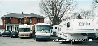
There are a
couple of sales places for RVs and the like along this stretch.
At the 1.2 km point, there’s
a little bridge with a nice little stream flowing under it – and all
kinds of
garbage along the highway to spoil the effect.
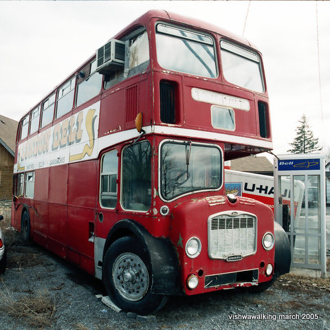
In 2005, there was an old
London double-decker bus parked on the south side
of Dundas along this stretch. It was used as a chip stand for a while,
but is long
gone now.
After the bridge, at the 1.4 km. point, I explored the possibility of walking by the shore, but after slogging through several soggy backyards, walking into a dead end behind some houses and doing the same thing behind a the storage facility/Canadian Cycling Company/Crane Plumbing warehouse, only to have the fence to the east of the falling-down old Bakelite plant block my way. Not recommended: put up with the highway.
I wove out in front of the Canadian Cycling etc. warehouse and then curved around through a ground-up wasteland below the tracks and just to the west of the old Bakelite plant. There’s something going on here, with trees and scrub-bushes all pushed aside and a big muddy expanse in its place waiting for “development.” The plant itself is probably rife with stuff that’s not too conducive to a person’s health.
Most
people think of Bakelite as a kind of brittle plastic that dishes and
carving sets
and radios were made of. It was also an ingredient in land mines. Not
sure if
this factory made Bakelite for that. Contaminants that are or were in
and
around the plant include phenols, solvents, PCBs in the
soil and in the
Demolition of the plant is
moving along at a good pace; as you can note below, on March 31 [2005],
I walked from
the chimney at the back of the plant eastward. Today, (2013) the
chimney is no more:
there’s just a pile of rubble and some cables stretching into the
bushes where
the chimney once stood. My chimney pictures were taken just in time.
History
moves on.
[I wrote the above in 2005. Here's a June 7, 2013 editorial from the Intelligencer describing the situation and both the new and old owners. The old scurrilous owner is on trial in Detroit. The land is still being fixed up and has gone through some horrible environmental issues (complete with sleazy businesspeople, etc.). Apparently it now is in good hands. Let's hope. -September, 2013]
Rating: 
From old
Bakelite plant to Herchimer
[Around
April 4, 2005, the Bakelite chimney was destroyed. I have left my 2005
chronicle of the state of the place at the time it was being taken
down, but see the 2013 photo for what it looks like today.]
March 31, 2005: The Bakelite factory is in ruins and when I walked it there was some activity there – some big machinery presumably wrecking and cleaning up.
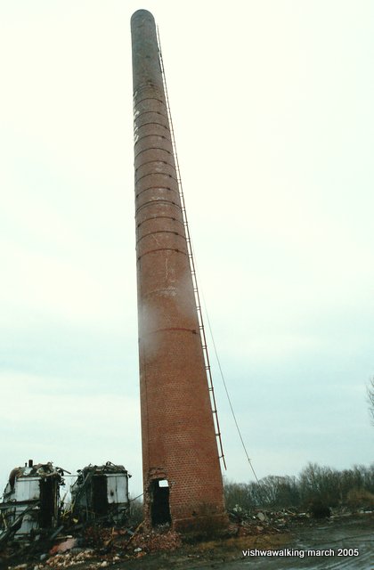 You can walk a short
distance from the chimney to a chain link fence, and staying south of
the
fence, follow the path as it wends its way to the wider rail bed about
five
minutes on.
However, before you do this, you should take the path south behind the chimney that leads to a little land projection followed by a spit.
Just
before the spit is a crumbled-down brick building that was once a pump
house.
It is surrounded by a dilapidated chain link fence. At the end of the
spit are
two bollards sunk into two cement blocks which are tilting precariously
in
various directions.
All along the spit are pipe fittings projecting from the ground every 20 or 30 feet. I’m not sure what their function was.
Follow the spit back and take the left (west) path that will lead you to the chain link fence mentioned above. There’s a nice “mini-forest” along this walk: some stunted trees with wide spaces between them; very pleasant. Unfortunately, yahoos have left their mark here and there: there are lots of signs of Coke, Labatt’s Blue and Tim Horton’s drinkers here.
At the fence, follow it west
until the path curves slightly south and along the edge of the marsh.
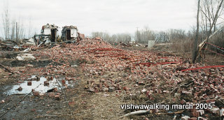
Below left: A few days later it was a pile of rubble.
Don’t try walking along the stretch of land between the two ponds in front of you unless you want to swim the last fifteen feet; curve south and you’ll eventually come back to the fence and onto the old rail bed. There’s a sign here saying “No trespassing,” referring to the area you have just walked.
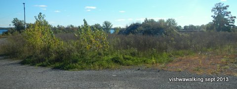
Right: The site of
the Bakelite plant on September 23, 2013. It's a desolate field
with nothing much to recommend it. Still, as in 2005, lots of promises
are being
made to turn it into something. We'll wait another eight years to see.
Don't hold your breath.
From here the trail is pretty straightforward. It’s not as civilized as the “official” trail just ahead, with quite a bit of refuse here and there, but I saw more wildlife (two herons, two rabbits and numerous ducks) in this stretch than I have in much wilder walks.
The marsh to the south is full of life. Total: 1.1 km., plus another 1.3 km if you take the loop to the spit (not included in distance total).
Rating:  (The last bit is the best.)
(2013: The
official route starts at Herchimer and is listed as "off-road" to the
north-west corner of South George Park, when it moves north up Front
Street to Dundas as an "on-road" section.)
This is a great trail for all
ages: it’s easy, well-maintained and has lots to see. If you’re in
downtown
The trail proper starts just
beyond
The trail deviates from the shore briefly at
“pier 31” a collection of
relatively high-end semi-detached houses built in a circle, with a nice
inner
courtyard. Signs at each end of the road into the houses advise that
this is
private property and there is no trespassing. The trail bypasses all
this and
soon after, you’re back by the shore and a marshy bit introduces the
A sign in this section indicates that sections of the waterfront are being restored to marshland to encourage wildlife (including fish), and indeed earlier on I flushed out a great blue heron.
A little further on is a monument to
Near the end of the walk is a building that
in the summer has
a concession stand and washrooms. Nearby is a boat launch. The Kiwanis
Club has a
sign here indicating their heavy involvement in the trail.
Follow the trail around to
In the summer, the harbour is
filled with boats. Today [March, 2005] the harbour has ice in it and a
couple of warning
signs saying that it is unsafe to walk on. It is actually pretty thick
still at
this time of the year (this year) and I took a couple of forays out
onto the
ice along the way, to check out the view from the bay. I walked out
along the
stone jetty to the mouth, then slipped across the ice to the green
light and
the 9 km. sign side. You get a good view of the bridge to
Continue the walk down
Pinnacle to
As I undoubtedly will lament,
the Lake Ontario Waterfront Trail is broken between
Rating: 


1.7 kilometres
(2013:
The official trail west is off-road from Front and Dundas. The Parrott
Riverfront Trail, which follows the shores of the Moira River comes in
from the north here and meets the waterfront trail under the bridge.
The official trail runs along the shore from Front and Dundas to just
beyond the water filtration plant, where it moves up again to Dundas
Street and switches briefly to an on-road section.)
March 28, 2005: Heading east on
The park has a very pleasant
shore path which shouldn’t be missed. By the bridge, just before it
curved back
toward the hotel, I climbed the bank and over the guardrail to get to
the
sidewalk over the bridge.
4.6 Kilometres
(2013: The
official trail is off-road to just past the filtration plant when it
returns to Dundas Street and is on-road briefly to Palmer Road where it
drops south briefly and runs south of the tracks to to Wilkie
Street where it returns to Dundas
Street. It is listed as a "connection" westward from here. You can also
follow an on-road connection to the waterfront trail which runs through
Prince Edward County to the south. I haven't done that, but it looks
interesting. Most of the trail is on roads, but much of it also
parallels the Millenium Trail, which is on an old rail line. So it
looks like you could take the Millenium Trail when possible to avoid
the roads.)
Back to April 25, 2005: A wet, unpleasant
day. I
clambered over the guard rails on the east side of Hwy. 62, and down
the bank
on the west side into Zwick’s Park. The park is quite open, so if
there’s any
wind, you feel it here. With a nasty drizzle it took some imagining to
see the
park in a better light. There’s an impressive RCAF
airplane on a post in the middle of the park. There
were also cars
cruising around the park roads and under the bridge. The park has a
reputation
as a pickup point for men, and I wasn’t sure whether I was vamping on
that
reputation as a couple of cars sat at the far end of the park with
their lights
on, but I felt that there was something going on here with the
slow-moving
vehicles.
I walked past the airplane
before cutting north to the railroad tracks and headed west to the
Gerry
O’Connor Water Treatment Plant (2001). While photographing the plant, I
was
(quasi-politely) challenged by an employee who was probably wondering
what a
bedraggled long-hair was doing wandering around the building with a
camera.
[2005 car photo here]
There
was a fine old classic
car in the parking lot (licence plate “Model Eh”) which I was
photographing
when two men came out of the building. They questioned me about
my motives. Surface polite, but suspicious. What was this long-hair
doing strolling by the plant?
Beyond the treatment plant, I
continued along the tracks. There is a bit of shore between the tracks
and the
water here, but it looked pretty thick with brush, and wet to boot, so
I stuck
to the tracks until I came upon a small mooring spot for yachts. There
are
several buildings here and quite a number of boats still beached for
the
winter.
An impassable chainlink fence is at
the end of the
walking path that runs between the filtration plant and the
shore. Cut north briefly to the tracks before the plant if you
want to move westward without climbing a serious fence.
September 23, 2013
There’s a road
from
Beyond that, along a muddy lane I ran into a
couple
of modest homes, followed by two massive homes under construction. This
is part
of the St. James By the Bay “Adult Lifestyle Community,” and a sign
announces,
“Phase One Now Under Construction.” To find out more, I could phone
613—966-1254, or check out "stjamesbythebay.com."
As I was photographing one of
the monstrosities, I was greeted by Alana Kalnay, who, with her husband
Boyd,
owns the new development. Behind the massive houses is a beautiful
little white
house (Alana called it a “cottage,” which aptly describes its “bijou”
quality)
where Alana said either she or Boyd grew up (I forgot which). The
Kalnays have
owned this parcel of land since the 1950s. Alana introduced me to Lisa,
who
also works on the project. Both were extremely pleasant and
informative,
especially since they were talking to an increasingly bedraggled
wild-haired
and now muddy-footed walker. I peeked inside the door of one of the
show houses
which was beautifully decorated. My shoes wouldn’t have allowed a tour.
To get to the development by
road, you have to cut south-west off
I walked past some huge piles
of dirt and into
[2013 update: If you leave the tracks at the point where the now more established suburban development is, you can walk through a huge field that belongs to St. James Cemetary. That gets you to the shore and a nice grassy bit (a good place for lunch on a sunny day).
Getting
into the cemetary now involves, either cutting back until a ravine
disintegrates into a ditch or making a brief but steep climb just north
of the shore through trees and brambles to the grassy order of the
cemetary.
It is peaceful here. This is an excellent
summer walk. The St. James Cemetary blends into
At
the western boundary of
the cemetery, there is a serious chain-link fence. I eventually found a
place
to climb it, but it wasn’t easy; you may want to walk out to the road
and
around the fence if you don’t fancy ripping some clothes. If you
drop down the steep embankment to the fence, you can slip around the
fence between it and the waterline, but it's a bit fiddly.
There’s a well-manicured open
stretch of field beyond the cemetery, which is the backyard of the
Beyond the field there was a great little cottage/boathouse by the shore, easily accessible but hidden away from the hustle and bustle of the road.
Beyond that, I walked through some wood and brush and a guardrail incongruously running by a trail to the water. Beyond the guardrail, is the mouth to Potter Creek, so after visiting it, it’s best to cut back to the trail and up to the road (Dundas St./Hwy 2).
Head a short distance along the grassy part
beside the
road, over the cement tunnel over
Rating: 
 (but a
three-walkdude for the cemetary and the Quinte Conservation Park)
From Quinte
Conservation park
(south of
(The
official
trail lists the section of Dundas from the aforementioned Applewood
Drive to Wallbridge-Loyalist Road, which is just east of the
conservation authoritiy's headquarters as a connecting link. From there
it stops and indicates that the trail ends, but will resume in 13
kilometres. How a connection differs from the next 13 kilometres of
road is beyond me.)
The conservation park has a
little arboretum on its west side, still looking spring-bedraggled at
this time
of year. It’s called the “Nortel Arboretum”; I wonder if Nortel, which
has
vastly reduced its presence in
It’s not possible to walk the waterfront from
the park; the
best you can do is
Back in Evil Ontario Premier (EOP for short)
Mike Harris’s regime (the mid-1980s), he removed this section of
Highway 2 from provincial
responsibility to municipal responsibility. We still have to put up
with the
chaos he inflicted on Ontarians.
Cars are moving pretty fast here, but still
it’s an OK walk if only for the big houses with long drives, spread out
along
the waterfront. There’s quite a mix, from modest to grand.
Soon after the park,
on the north side of
On the south side, the
Not long after the golf
course, there’s a gas station on the south side, followed by a field. I
headed
back to the waterfront here and wended my way west through some long
grass
(easy) followed by some thick brush (not so easy). I also had to sneak
by the
bottom of some people’s gardens until I reached the east end of


I spent a lot of time today
bouncing back and forth from often marshy waterfront, people’s back
yards and
Old Highway 2. I walked a short bit down the highway to a laneway
identified by
a small sign indicating “Apperley Construction.”
A short stretch down the lane,
I came upon a bridge and headed into the woods just after I had crossed
it.
There are a number of pathways and bridges in the woods immediately to
the
east, and I took the first pathway. A grassy path led me to a beautiful
rustic
garden, just unkempt enough and just cultured enough to make it a fine
escape.
I followed the lane to the end, where there was a little A-frame
cottage. The
next house over, a dog started barking, so I moved back up the lane,
past a
couple of funky bird houses and through a rough hedge into a field.
That led me to a new housing development (moving away from the lake somewhat, but not to the highway) called “Settler’s Landing.” Houses here are in the trendy massive style, lots of brick and stone, probably billed as an “adult community.” Davanco Homes (966-4499) are doing the developing. More waterfront that will never be public.
At the end of the eastward part of Settler’s
Landing, instead
of curving back to the highway, I headed into a pleasant field with
quite a few
little trails. That opened into
I stayed on Hunt Street, passing Alice Avenue and Ghent Drive, moving smoothly into Dorothy Drive (Who are all these streets named after? Probably family members of the developer. Real history here.) At the end of Dorothy Drive, I kept on straight, traversing a wet gully (and got two soakers) before climbing a bank to a nice big field. This was probably the most relaxed part of the walk.
There’s a big pond north
of the lake just before another residential area. I stayed north of it,
but
it’s possible to cut south of it. Before the houses start, you’ll run
into a
chain-link fence. If you move toward the lake, you’ll find an opening
onto
Now committed,
I headed into the marsh and actually made my way through it with only
slight
water damage, to the bottom end of Bayview Rd. Staying off the road, I
plowed
on westward through a few back yards and mushy fields until the fences
and
houses looked too daunting. I headed nback to the highway through the
Avalon
Motor yards, where a very tired old windowless
From here, it’s back to a bit of highway walking, past Colangelo Uvent Wine’s fine building on the north side and a couple of old plough’s ornamenting a person’s driveway on the south side until I reached White’s Cemetery. This is a nice little break, and you can get right to the lakeshore here before heading east off into a field (past the “private property” signs).
As I approached the garage property, I cut
into the
woods as it looked like the easiest way to make it out of the field.
After a
brief walk through the bottom of the garage property, I negotiated a
minor
swampy area before heading up a bank into a field with lots of trails
leading
hither and yon. If you keep roughly eastward, a trail will take you
between a
break in the houses lining
Rating: 

Quinte View Drive and Old Highway #2 to Middle and Front Streets, Trenton
5 kilometres
Past the headquarters, on the
west side of the south lot are a number of quite nice houses (of course
still
imprisoned within the fence), followed by, at the far western fence
unimaginative warehouse-style barracks, for the non-officers.
Immediately after the base,
is
At the west end of the park
is a very straight stream and on the west bank of that is a string of
fence
that borders the edge of the
At the end of the trailer
park road, I had to head back to the highway yet again. You can slip
around a
couple of trees and walk around the back end of the west side of the
trailer
park. Near the highway, I passed Wheel ’n Deal Bicycle Repair, which is
a
makeshift repair shop beside a trailer; it reminded me of little
private
industries in poorer areas of
A short bit down the highway, I got back to the shore by walking behind Smylie’s Independent Grocery Store, followed by the backside of Canadian Tire. There’s a nice mini-spit behind Canadian Tire, where you can get a good view of the bay. Walking out on it is a little precarious; broken pallets have been placed over wet spots. It’s a nice spot to unwind in the summer while you wait for your car to get fixed, or to wait for your spouse while he/she gets lost in the automotive goods.
Heading westward, I
passed through a line of trees, behind Trent Valley Lodge and through
someone’s
backyard (very nice, not upscale, but relaxed). A bit of swamp can be
avoided
by sticking close to the shore, but I had to leap over a dirty creek at
its
mouth.
A large parking lot follows, and then a
sewage plant. Finally,
announcing the mouth of the
When I walked it, there were all
sorts of people getting ready for fishing season, which opens on
Saturday, May
8. According to a couple of guys I spoke to as they stood by their
pickup a few
feet from their tent, the authorities allow camping here on opening
day. Most
campers had brought trailers and were parked by the marina on the
western side
of the park, where there are a number of berths for boats. Trailers
were lined
all along the shore, and a little community was forming. A big
organizational
tent was erected a little further north, near Highway 2/Dundas St.,
along with
a rough-and-ready cafeteria called Pete’s Eats, which didn’t seem like
it was
in full swing when I walked by.
The park also had an impressive open stage. When I walked by, a father and son (I assume) were flying a kite there.
The
official trail picks up again at centennial park.
Curving up to follow the
mouth of the river’s edge, I headed west across the
Rated: 
 (The
parks are nice; the road bits are only worth a one-walkdude rating.)
6.2
kilometres
March 17, 2005: Extensions eastward
from Centennial are
coming soon, so they say, and there’s a loop in
Start at Middle and Front
streets near the Quinte West Chamber of Commerce (it has got a big
Travel Information
sign on the roof). At the chamber of commerce, you can get all kinds of
brochures, including those with maps of local trails. Remember that
this is ATV
and snowmobile country, so many trails described in the brochures are
“multi-use,” which means machine-centric. All other users take some
risk. At
its worst it’s like walking down the middle of a road dodging
high-speed
vehicles.
Walking south along the western
bank of the river is pleasant. There are lots of restaurants just
before the
bridge: Tomasso’s Casual Dining, the
Today, I just breeze past and follow the
trail past a sundial
(upon which is inscribed “Trenton Renaissance: Phase II Waterfront
Development
– Opened October 21, 1995”) and under the bridge. The path under the
bridge was
a skating rink; take care you don’t flip on your backside.
From the bridge, follow the
path around and through the park. There’s a here sign that reads “No
fishing
between signs” but there was only one sign that I could see, unless the
other
one was out of sight a mile or so away. Walk
through the park and the arches that record the lives
of soldiers
lost in the two world wars, and on up
Walk across the park, behind the new municipal building/library (it looks much more impressive from the front). It should be noted that there are no trail signs here, and after the short downtown section, no indication that any effort has been made to create a trail.
I walked along the shore, following an old rail line along the side of a drab factory building and all the way out to the extension of Dufferin Street and the shore. A couple of military planes flew low over me during this walk; perhaps it’s a good spot for military plane spotters.
As
mentioned above, the official route connects to
March 21, 2005: Extension of
Again, the official waterfront trail should
be only a guide. It
suggests walking Carrying Place Road, which is a boring stretch and is
used by
large trucks and cars traveling at high speeds.
I walked on the
ice. This is not bad: you get a good view of houses situated right on
the Bay.
Quite a mixed bag, but interesting. How
you could exercise your right to walk the shoreline is difficult to
imagine,
with fence lines right down to the waterfront.
As the ice was still solid,
again I travelled along the shore. However, if the ice is not an
option, follow
the old railway line. I walked on that for part of the way (or next to
it, on
Walking along the ice on the
waterfront makes for quite a varied scene, and with little snow on the
ice it was an easy
walk. Again homes vary from the modest to the grand. People obviously
feel they
own their waterfront, as they’ve built all manner of things right to
the
waterfront. Some people have used the bay to dump organic waste –
grass, wood
chips and ashes were just dumped on the ice, presumably to fall through
to the
bottom of the bay in a few weeks.
To the west of the mouth of
Dead Creek, a number of homes have their own quays. There are some
interesting
boathouses here.
I walked back to
Rated:
 I
debated this one: if you like varied urban and scruffy
landscape, add
a walkdude. There's definitely interesting stuff happening here if
you're not partial solely to rough bush or English country gardens.
Moderate, because of the human-made parts of the landscape can be
challenging.
Back to the top of this page
Home | Contact Us | Site Map