About Us
Vishwawalking explained
 Ratings Explained
Vishwawalks
Day walks
Funky Places
Future walks
Food
Gear and Health
Get Lost
Good reads
Links
Plants - Animals
Right to Ramble
Site map
Contact us
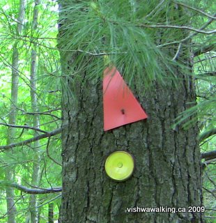
A typical orange triangle indicating trail direction. Sometimes you have to look carefully; new growth may partially obscure a triangle. This one has a yellow tip, so it's for walkers travelling south. The northward triangles are a solid orange. I'm not sure what the yellow -painted tin-can end is for; it was on a section of the trail north of the Gould Lake Conservation Area. There were blue tin -can ends on another section.
Vishwawalking
Rideau Trail
Map - Kingston to Frontenac Provincial ParkIf you are going to hike more than a few kilometres of this trail, I
highly recommend the Rideau Trail Association's trail
guide.
You can buy a set of maps for the trail from the association. You can also view the maps on their site. The maps have been updated to 2012 and 2013.
You can buy a set of maps for the trail from the association. You can also view the maps on their site. The maps have been updated to 2012 and 2013.
The latest guide book is 2006; there are no hard copies available at present. Apparently an online version is being prepared.
I still use my 2001 edition and check the website for trail changes and updates.
The guide has excellent descriptions of the flora and fauna you might expect at certain sections. It also has good maps.
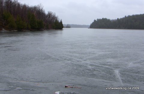
Gould Lake on a wet
day, April 1, 2009, with ice still on the lake. The rain was
steady all day, it was a bit chilly, everything glistened with wet beauty — a perfect
day for a walk. With warm dry clothes, a bit of a lunch and a comfort beverage
of your choice (we like cider) what more could a walker want?
steady all day, it was a bit chilly, everything glistened with wet beauty — a perfect
day for a walk. With warm dry clothes, a bit of a lunch and a comfort beverage
of your choice (we like cider) what more could a walker want?
History
In 1971, Doug Knapp proposed a hiking trail to the Kingston Field Naturalists, to run to the north of the city. The idea expanded to run a trail all the way from Kingston to Ottawa.
 Two public meetings were
held in Kingston and Ottawa respectively and the idea was
enthusiastically received.
Two public meetings were
held in Kingston and Ottawa respectively and the idea was
enthusiastically received.In March of the same year, some university students heard of the proposal and suggested the trail be built over one summer, using an "Opportunities for Youth" grant. These were federal grants made by the Liberal government of Pierre Trudeau in which thousands of young people were employed doing all manner of things. (I know: My wife, Carol, and I started the Double Decker Touring Theatre in Peterborough Ontario and I and nine others got $90 a week to put theatre on in the area. Unfortunately, we didn't get a double-decker bus. Close, though.)
Back then, grants were much more easily approved and all sorts of fine community work was done. The Rideau Trail Association was set up, with committees in Kingston, Ottawa and Smith Falls.
In mid-May, 1971, 27 students began building the trail, with volunteer route and negotiation committees working to keep up with them.
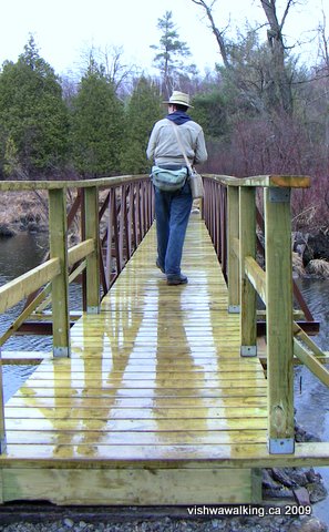
The Marion Webb Boardwalk on in the Gould Lake
Conservation Area. I do go on about it, but I love this
section and the associated blue trails. Between Gould
and Frontenac Park just to the north, it's a walker's dream.
By June an inaugural hike was held in the Gould Lake Conservation Area north of Sydenham (still one of the best sections of the trail I have encountered so far, and overall one of the best trails in southern Ontario). A continuous trail was set up by the end of August.
 The opening ceremonies were held north of
Westport at the Foley Mountain Conservation Area in November of 1971.
The trail association
already had about 250 members at the time.
The opening ceremonies were held north of
Westport at the Foley Mountain Conservation Area in November of 1971.
The trail association
already had about 250 members at the time.There are three clubs associated with the trail. Members organize trail and other walking events throughout the year.
The three clubs are Ottawa central (Perth) and Kingston. Check out the association's site for specific information. The club has about 1,200 members.
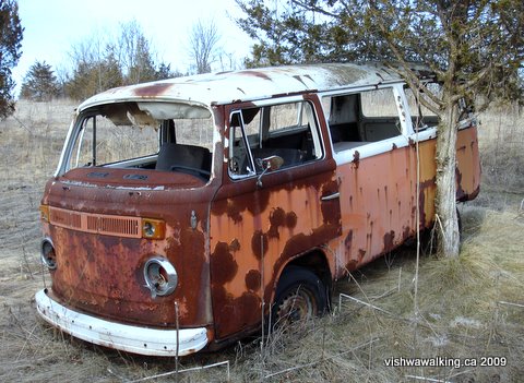
It's not all nature: there are
plenty of discarded bits and pieces of buildings
and machinery along the way. This Volkswagon bus has long ago seen its last days
on the road and grazes peacefully in a field just north of McIvor Road.
and machinery along the way. This Volkswagon bus has long ago seen its last days
on the road and grazes peacefully in a field just north of McIvor Road.
(This information — except for the stuff about me, which the guidebook inextricably left out — is drawn from page one of the 2001 guidebook and from the association's web page.)
Map - Kingston to Frontenac Provincial Park
Description of the Trail:
1. Kingston (start) to
K&P Trail (Sydenham Road) just south of the #401.
Starting point is the Cataraqui Marsh Conservation Area on King Street.
This section includes the Helen Henrikson Loop.
2. K&P Trail and Rideau to Sydenham.
This section includes the sections of the K&P which are not part of the Rideau.
3. Sydenham to Frontenac Park
External Links:
2. K&P Trail and Rideau to Sydenham.
This section includes the sections of the K&P which are not part of the Rideau.
3. Sydenham to Frontenac Park
External Links:
Rideau Canal Heritage Site
This is an excellent page with all sorts of descriptions of trails
surrounding the Rideau Canal, with links to other good sites.
Back to the top of this pageHome | Contact Us | Site Map
Page
created: February 17, 2009
Updated: June 26, 2013
Updated: June 26, 2013