About Us
Vishwawalking explained
 Ratings Explained
Vishwawalks
Day walks
Funky Places
Future walks
Food
Gear
Get Lost
Good reads
Links
Right to Ramble
Site map
Contact us
Vishwawalking
Rideau Trail
Kingston (start) to K&P Trail at Sydenham Street
MapFor more photos of this section click here or on any photo
1) Cataraqui Bay Marshland Conservation Area to the Viarail Station
Total: 5 kmRunning total: 5 km
 The
trail starts where King Street and Front Road meet. King
Street
East come in from central Kingston, running first just north of Ontario
Street, then along Lake Ontario, eventually turning into King
Street West. It's
about 5 km from Princess and King Street East
(downtown
Kingston) to the start of the trail.
The
trail starts where King Street and Front Road meet. King
Street
East come in from central Kingston, running first just north of Ontario
Street, then along Lake Ontario, eventually turning into King
Street West. It's
about 5 km from Princess and King Street East
(downtown
Kingston) to the start of the trail.You'll see Trailhead Place on the north side, heading off to an apartment complex. Take that, then almost immediately turn right into the conservation parking lot.
I walked this bit with my wife, Carol. The start of the trail is very promising, winding north along the edge of the marsh on the left and the Cataraqui Golf Course on the right. Through the hedge that separates the trail from the course, we watched a flock of Canada Geese milling about on the golf course lawn.
The trail has boardwalks at potentially wet spots.
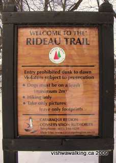
The sign at the start of the trail. Notice
that dog leashes are limited to a maximum length.
The sounds of the city come through loud and clear, so you're caught between the marsh environment and the urban environment not far away. Make sure you stay left and don't turn right into the golf course at the beginning. You'll see the railroad track on your left before you cross it at the 1.5 mark. A bit further on you cross over the tracks again and you'll see some apartments through the trees, on your right. You'll come to Greenview Drive. Make a left here, then another at Queen Mary Road.
This suburban section is boring. You'll pass an animal hospital on your left at Queen Mary and Bath Road. Across the road things get more interesting, but the trail is rather straight here. Before you pass through the little gate to stop vehicles, turn left or right and you can walk a piece (or all) of the Helen A. Henrikson Loop. Follow the trail left or right and you can do part or all of the 1.6 loop. I recommend you do the entire loop; it's one of the best things about this section, and gets you close to Cataraqui Creek.
The Helen Henrikson Trail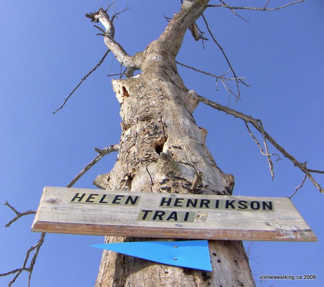 This
1.6 km side loop is a fine little trail that circles
over the main trail. It leads through some young hardwood bush, by a
creek and close by Little Cataraqui Creek (which is not so little at
this point). If you head off to the east the trail will soon start to
rise up and skirt behind the backyards of houses. You'll come
to a
cut-off that leads to the right, into the Grenville Park Cooperative
Housing Association's private park. It's a nice little green space,
with benches, and facilities for kids; a great place to stop
for a
picnic. You can get to it from Elmwood Street, just south of Westwood
Street. The park is also a way of getting onto the trail if you just
want a short walk. I got to the trail from Grenville Crescent, which
also will get you to the park. You'll see little side trails the locals
have made to get to the trail. This
1.6 km side loop is a fine little trail that circles
over the main trail. It leads through some young hardwood bush, by a
creek and close by Little Cataraqui Creek (which is not so little at
this point). If you head off to the east the trail will soon start to
rise up and skirt behind the backyards of houses. You'll come
to a
cut-off that leads to the right, into the Grenville Park Cooperative
Housing Association's private park. It's a nice little green space,
with benches, and facilities for kids; a great place to stop
for a
picnic. You can get to it from Elmwood Street, just south of Westwood
Street. The park is also a way of getting onto the trail if you just
want a short walk. I got to the trail from Grenville Crescent, which
also will get you to the park. You'll see little side trails the locals
have made to get to the trail. After the trail rises, it comes down once more and meets a little creek. The backyards of houses are all around, yet you get the feeling you're more remote than you really are — and that's a good thing. 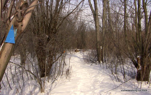 After crossing the main trail, you will soon come to Little Cataraqui Creek/River (different maps have different designations). It's a wide expanse of water and not a creek at all. In winter, you can follow a little side trail out onto the ice and get a good view of the bridge and the spewing factory stacks back towards the lake. On the opposite shore are a line of suburban houses, their back yards sloping to the water. Back on the trail, you can loop back to where you started. 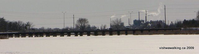
Top: A sign on the Rideau Trail indicating the Helen Henrikson loop. Middle: The blue triangles indicate a side or spur trail. The trail is well marked here. Bottom: Standing on the ice looking south on Cataraqui Creek, just off the Helen Henrikson loop trail. That's the Bath Road bridge stretching in front of the DuPont smoke stacks. Photos: February 21, 2009 Walked:
February 21, 2009
|
The trail eventually straightens out into the Parkway (boring) before you get to Princess Street, where you'll turn left (more boring). About .3 km eastward on Princess, watch out for the signs that will take you right and down an incline toward the railroad tracks. Follow it to the tracks and then turn to the right to the station platform. At the station, go into the building and take the underground passage to the main station, where you can enjoy a sit-down and some overpriced substandard food. Sarcasm, aside, on a chilly day,with the wind blowing down Princess Street and along the platform, the station can be a welcome sight.
Rating:
Suburban sections: Helen Henrikson loop: Walked:
November, 2008
2) Via Railway Station to Sydenham Road and K&P Trail, via Cataraqui Cemetery
Total: 3
kilometres
Running total: 8 kilometresHead out of the railway station into the parking lot, turn sharply left (west and back toward Princess Street) and follow the road as it curves right (north) to Counter Street. Turn left here and you will very shortly come to Purdy Court. Follow this to Purdy's Mills Road and then turn right, past the quaint offices of the Cataraqui Chiropractic Rehabilitation Centre to the gates of Cataraqui Cemetery. (If you check out this site, be sure to click on the "Explore" button to look at the interactive map. It has some good historical information.)
This is where things get interesting.
Continue up the hill into the cemetery, past the big Rideau Trail sign and the cemetery sign. The Superintendent's Cottage on the right was built in 1854. It has some fantastic Gothic teardrop trimming — like an early version of the Christmas frost decoration people string on their houses .
Turn right into Maple, where you'll see the first of a number of statues of white damsels in scanty clothing, cracking with the cold on the February day I walked this bit. Turn left into Beech Avenue and you'll come upon the graves of Sir Alexander Campbell (1822-1892), a father of Canadian confederation. He was also the first chairman of the Catarqaqui Cemetery Corporation, so he was obviously able to pick a good spot to be buried, just south of Sir John A. Macdonald (1815-1891). Sir John's mum and dad, Isabella Clark (his first wife), two sisters and a son are also buried here..
After checking out the two graves, move on up the hill and turn right on Evergreen to West Avenue. On your right, you'll see rows on rows of little grave markers. This is a military plot, deeded to the war department in 1865 and now looked after by the federal Department of Veteran Affairs. It's worth a detour, looping past an old barn just outside the cemetery.
Back on West Avenue, stay left and take Pine then Spruce avenues to get to the northern gates on Sydenham Avenue. If you're in the cemetery on a fine day, it's worth exploring the little gullies and side roads; the cemetery definitely a good place for a picnic. I'm sure Sir John would appreciate it if you had a little celebratory drink by his grave. He'll really appreciate it if you sprinkle a drop or two on his grave.
Turn right on the busy Sydenham Road. This is a boring section, but you can amuse yourself by checking out some heavy equipment at the "New Holland" dealership. Wanna buy a mini tank, put on your khakis and play guns? Here's the place to buy your tank.
Head north just under 600 metres to the K&P trail.
Rating: Road sections:
Easy. Cataraqui Cemetary: Easy.
Walked:
February 21, 2009
How to get there:
The trail starts at King Street West, just west of the Cataraqui Golf and Country Club. The easiest way to get there from Highway #401 is straight down Sir John A. Macdonald Boulevard. Just short of 6 kilometres south, you'll run into King Street West. Turn right (west) and travel for 2 kilometres to Trailhead Place and turn right (north). King Street West turns into Front Road. If you cross the bridge over Little Cataraqui Creek and see the DuPont plant on your left, you've gone too far.
The Viarail station is on Counter Street, north of Princess and just to the east of the bottom of Sydenham Street. From Highway #401, exit at Sydenham Street. Just over 2 kilometres south it ends in a "T" intersection at Princess Street. Turn left (east) and a couple of hundred metres along turn left (north) onto Counter. It will cost you to park in the Viarail parking lot however. Find a place in the Cataraqui Cemetery, along Sydenham Road, or where the K&P Trail meets Sydenham Road just south of Highway #401.
Back to the top of this page
Home | Contact Us | Site Map
Page
created: February 17, 2009
Updated: August 1, 2009
Updated: August 1, 2009