About Us
Vishwawalking explained
 Ratings Explained
Vishwawalks
Day walks
Funky Places
Future walks
Food
Gear
Get Lost
Good reads
Links
Plants - Animals
Right to Ramble
Site map
Contact us
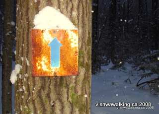
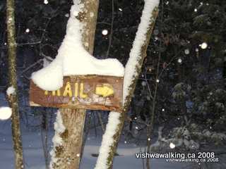
As well as the wooden trail signs on the nature trail, there are a number of more basic metal signs like this. February 9, 2008
Vishwawalking
Vanderwater Conservation Area (Vanderwater Park)
MapsFor more photos click here
Vanderwater Park: An Ice and Water Pictorial Essay
How to get there: Starting at Highway #401 and
#37 out of Belleville, Ontario, head 24 kilometres north on
#37, to
Thomasburg. Turn right on Vanderwater Road just before the
gas station.
In 2.6 kilometres, just after you cross the Moira River,
turn right
into the parking lot.
I
am biased when it comes to Vanderwater Park. It's a few
kilometres from
my home, but my family considers it our back yard.
The park is made up of 257 hectares (635 acres) of land bordering the Moira River. Quinte Conservation says it has 16 km of official trails. That's wrong, because it counts the same trails twice and closed one official trail some years ago: the blue and green trails are just shorter pieces of the red trail. The park has about 12 kilometres of trails, counting the roads and about 8 km not counting the roads. Since some of the road will soon be opened again (up to the scout camp), it's hard to count that part as trail.
A little bit of history: Colonel Roscoe Vanderwater was the first chairman of the Moira River Conservation Authority (MRCA), one of the three authorities that were later amalgamated into Quinte Conservation. (The two other authorities were Prince Edward County and Napanee).
On July 31, 1947, the MRCA the was created. Vanderwater became its first chairman and in 1948, its secretary-treasurer, a post he retained until his death in 1957. The present park area was opened in memoriam to him on August 1, 1960. It was originally 168 hectares (500 acres) but was subsequently enlarged in three separate purchases, the last one being in 1968.
A camping area at the back of the park was opened in 1963. In the next 10 years, a plan was developed to move the campsites back from the river to allow more public access, but it never became a reality and camping was banned in the park in 1980.
There is a scout camp in the park. Two cabins, a main building and a large field are maintained by local scouts.
In its heyday, there was a demonstration pasture and a demonstration pond near the gate to the park. Beginning in the mid-1980s, successive government cutbacks led to the slow erosion of maintenance in the park. In the mid-1990s, local authorities talked darkly of selling certain conservation lands. Vanderwater, which once had groomed ski trails, regular grass mowing, maintained picnic tables and outhouses and an "interpretive nature trail" complete with boardwalks, gradually slid to what it is today.
For walkers, the main loss is the "interpretive trail." I've still noted it in my maps and describe it here, but signs in the park warn walkers away. It's still possible to walk, but there are difficult (and potentially wet) points. Other trails are excellent for walkers. Overall, the park has lots to offer. Don't expect outhouses and take your garbage out with you — there are no garbage cans. These things are small potatoes for a walker; the trails meander through the park, sometimes on the old roads close to the river and sometimes along a high ridge back from the river. A swimming spot at Flat Rock is a great place to cool off in the height of summer; sit with your back to the little rapids and let the water massage your back and clear your mind. This is a great park, and it's my home.
 The
three colour designations of the trails
overlap, with all trails starting at the parking lot, so the
blue trail
is really the red trail with a shortcut to allow you to head
back
early. Same with the green. Therefore to travel the red trail,
you
start off on the blue/green/red, move to green/red and do
the
final loop on the red. The trails are wide, so it's hard to
wander off
them. With the maps, you should have no trouble. (By the way,
any
brochure and online stuff on this park that I've seen
indicates there
are 15 kilometres of trail. There's actually under 12
kilometres,
if you count the closed trail and all the unofficial
little
trails at the very back of the park. If you count only the
publicized
trails, there's just over 8 kilometres.
The
three colour designations of the trails
overlap, with all trails starting at the parking lot, so the
blue trail
is really the red trail with a shortcut to allow you to head
back
early. Same with the green. Therefore to travel the red trail,
you
start off on the blue/green/red, move to green/red and do
the
final loop on the red. The trails are wide, so it's hard to
wander off
them. With the maps, you should have no trouble. (By the way,
any
brochure and online stuff on this park that I've seen
indicates there
are 15 kilometres of trail. There's actually under 12
kilometres,
if you count the closed trail and all the unofficial
little
trails at the very back of the park. If you count only the
publicized
trails, there's just over 8 kilometres.
I'll note the few spots where you may get turned around, especially the trails at the back of the park, which are not used often.
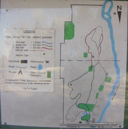
The trails were outlined on this sign at the entrance to the park. It has since
been taken down (this photo was taken on March 13, 2009). Today, maller maps are
posted on signs at different points on the trails. They are a bit hard
to read, but have patience!
Today (in 2021), the trails have been remarked. However, the marking is not consistent. For example, the red trail markers end at the back of the park. You have to walk along the road and cut in just before the gate, without help from markers..
My GPS calculations differ slightly from the trail distances on the sign.
Don't be put off by the masses of dog shit often found at the beginning of the trail, left by irresponsible pet owners. Sometimes fast food debris can be a bit nasty; however it dissipates a few hundred feet in. Regular walkers do occasional clean-ups.
After your walk, you can head to one of several picnic areas just off the road. They have picnic tables and look out on the river. Very nice.
There is really only one main trail in the park: the red trail. It heads out south past the pond and the back of the scout camp, rises to a ridge and carries on past the hydrpo lines and eventually to the road at the back of the park. The road then takes you back north closer to the river, before cutting left (east) just before the gate under the hydro lines. The return trail continues between the road running beside the river and the upper trail you came out on, back to the parking lot. Again, there are few markings on this section.
The Blue Trail
Loop trail: 1.3 kilometres from the parking lot
Go through the little iron gate (not the big road gate) off to your left and keep to the left (again, don't follow the trail beside the road).
The trail heads through a pine wood, then curves to the right when it reaches an old cedar fence..
In 2009 in this area, a goshawk family made their home, close to the trail. They were not around in 2012, or moved further into the park. The adult birds used to dive bomb walkers, which can be unsettling; the big bird could come very close to your head. If you hear its distinctive warning cry, I recommend skirting the area.
Just after you make the first right turn, you have a choice. You can get a bit more of a workout by climbing the hill on the right or you can continue straight on the trail. Either way, the trails join once more just before the pond.
If you don't take the hill, part way along the low trail, a path leads of to the left. This gets you onto the nature trail, near a little creek that runs into the pond.
The pond was once a fine skating area. Over the summers it has dried up and is less grand. Still, if there was initiative, there could be a fine skating pond there. Curve around the end of the pond and turn left, walking along the berm with the pond on your left and the road on your right (and the return trail squeezed in between.) The start of the nature trail runs off left just as you enter the trees again, with a sign advising you not to take it. Keep straight on up the hill then follow it down again. As you reach the bottom, keep an eye out for the right tyrn and follow the trail up slightly (if you continue straight ahead, you'll be on the is the red/green trail).
You're now bypassing the scout camp on your left. When you get to the "T" intersection, turn right and you're on your way back, up the hill then down again, across a little bridge. Cross a second tiny bridge, curve slightly right into the pines and follow the trail by the road back to the parking lot.
Loop trail: 4.5 kilometres from the parking lot
 The
green trail continues straight on from the point the the blue
trail
turns right; in fact most walkers consider this one single
trail and the blue turnoff just a shortcut.
The
green trail continues straight on from the point the the blue
trail
turns right; in fact most walkers consider this one single
trail and the blue turnoff just a shortcut.
The trail passes through a low area that's muddy in the spring, then swings to the right and up toward the fields of the scout camp. Before you reach the field, watch for the nature trail (now unmarked) running off to your left through a row of trees. The main trail opens into a little field. There used to be a little picnic shelter here, but it rotted away until somebody (scout or park authorities) ripped it down. I was sad to see it go; it was a favourite writing spot of mine.
Continue through to the big field and cut left past the giant fire circle installed by the scouts in 2014. On the south side of the field you'll see the trail opening and some boulders inside the ridge of trees. Cut left as soon as you're into the trees and follow the trail along a potentially wet section until you turn right and climb a steep hill. From here the trail follows the ridge briefly and you get a view down to the river before the trail cuts back into the trees.
Just before the lean-to resting spot on the green trail.
This is the trail after an April Ice storm in 2013.
At the 400 metre point from the bottom of the steep hill (very roughly) you'll find a little shelter where you can sit and rest. When you leave the shelter, you'll curve around and climb a hill. Deer like the valley at the bottom of the other side of the hill; if I'm quiet I'm often rewarded here.
About a kilometre from the shelter, you'll have a choice: continue straight along and up a hill onto the red trail, or curve right through a straight line of pines before curving back. In the dusk, this is a beautiful dark and deliciously ominous "hallway." As it opens up, there's yet another fork in the trail here.
To stay on the green trail, curve to the right at this fork, in the direction of the parking lot. Alternatively, you can cut to the left down the hill, with the hydro lines above you just slightly to the left. At the bottom of the hill is the road. You can now take the easier low road along the river's edge back to the parking lot. Alternatively, refer to the map and check out where the road to the left goes. This is the return path of the red trail and takes you to some pleasant and often unpeopled spots along the river bank.
If you stay with the green trail, you'll take a few ups and downs before riding high on the ridge, with the sound of the rapids below you. A little side trail heads off to the left then loops back to the main trail. It cuts right along the ridge edge and you can look sharply down into the woods as they drop to the river's level. At the point the trail cuts back to the main trail, look sharp and you'll see an overgrown trail leading down to the rapids. And there—hey, presto!—are a set of cement stairs to lead you down. At the bottom of the hill, there's a trail off left to an old spring. Years ago, it was drinkable. Those in the know don't advise that now. It still looks very refreshing as it bubbles from the earth.
If you don't follow the spring trail offshoot (it's pretty overgrown these days), take the little wooden bridge to to a small field, the road and then the rapids. (Take care on the bridge. it's rotted, but still a safer bet than negotiating the ditch it spans. Let's hope no one decides its safer to remove it. Even better, let's hope someone coughs up a few dollars to fix it.)
Back to the main trail on the ridge: stick to it and you'll go down a hill. At the bottom of the hill, where a little trail off left leads to the road which is very close. Continue on over a small bridge over a tiny creek and along the front of the scout camp, just inside their gates. As you pass from their field into a smaller open area, you'll see a big area where the scouts have campfires. The trail then leads into the woods and connects with the blue trail again.
Loop Trail: 8 kilometres from the parking lot.
The red trail, as mentioned above, is the blue and green trails minus the "shortcuts" bits. It's 7.3 kilometres, and so makes for a good healthy afternoon walk.
From the green trail, it climbs up through mostly hardwood, with some softwood forest to your right until you reach the hydro lines and pass tower #733. The trail itself is very clear, although the red trail markings are almost non-existant. There are no side trails to confuse you.
Shortly after the hydro lines, you'll come to another shelter. There are some interesting ups and downs on this bit. At about 1.6 km from the hydro lines, the trail meets the road. At this point, you have a choice to go right or left. The roads eventually join, so it amounts to the same thing. The left turn will lead you down a hill and turn right near the river. From there it will follow the river.
By the way, one of my topos shows a road continuing south and connecting with the Moneymore Road. There is a trail I'll describe below; there is definitely not a road.
From here, you can take the high road back to the parking lot (turn right0, or follow the low road near the river. There are also a number of fine picnic spots partway along this stretch, but see below re private property. Watch out for the poison ivy here. It's mostly near the road, but there's also some near the river.
Re the private property: Just under a kilometre from the point you first meet the road, you'll come to an open space where there is a picnic table and a circle of rocks for a fire. This used to be an excellent picnic spot. However, in 2015, the property across the river (west side) was purchased and it apparently included property along the river (east side) that had been park property since the fifties. Now this property is marked as private and the road is the only place you can walk without trespassing. In winter, this is no problem: sit at the picnic table, eat your lunch and continue. In summer, you could get some flack from the property owners if they're around.
As the low road curves right and upward to meet the high road, you'll see a path continuing along the river. It's a nice route. However, you'll have to initially avoid quite a lot of poison ivy here.. It's highly overgrown these days and I seldom use it. Still, it could be worth the effort.
If you stick to the road, you'll soon come to the hydro lines, only this time at the bottom of the ridge you were on for your outward walk. You can cut to the right and follow the green trail back (watch out here, as the path is clear, but there are no markers) or go past the gate and take the easier road back. If you take the road, there's a side road off to the left before the rapids where some people picnic out of their cars and sometimes swim. It's a bit muddy, but the water is moving slower than at the rapids. If you want to laze about more, it could be the way to go.
If you want to swim at the rapids, the easiest way is to walk past the rapids and into the little sideroad just to the north. Behind the parking lot, you drop down and cross a little side creek from the main river to an island. (Often the side creek is dry, so it's not much of a challenge to cross, except in the spring.) From the opposite side of the island, you can walk across the rocks to the opposite side of the river, where you'll find the best swimming. Watch out for poison ivy on the island. The volcanic rock on the river bed can be sharp, so a pair of river runners is advised.
Along the road back to the parking lot are another four sideroads off to the left (west) with picnic spots by the river.
Total: 1 kilometre
As mentioned above, the Nature Trail is in extreme disrepair these days. In its heyday it was a fine trail. It's a good trail if you're willing to negotiate some very wet bits and tolerate deadfalls and some confusion.
In the mid-eighties, the Belleville-based Quinte Field Naturalists built the trail. It was an ambitious project considering the trail goes through some wet areas. That's also it's allure: without the trail, it's pretty well impossible to wander through some of the marshy terrain. The trail is strictly for walking. It doesn't suit cross-country skiing. As opposed to the larger trails in the park, it's a single-file path through the woods.
Boardwalks once allowed such access got walkers over stream and through boggy areas. However, many of the boardwalks started to rot by the mid-nineties. Around 2005, they were ripped up, presumably for safety's sake. In fact, for those who still use the trail, it became more treacherous. Some stalwart has replaced a few boards singlehandedly, but if you walk the trail be prepared to do some balancing acts and wear waterproof footwear. The little wooden bridges over a couple of streams have been ripped out too, even one that was in good shape.
The trail starts at the south end of the pond and runs east off the blue trail. A short distance into the trees, you'll come across a little stream with the most bizarre "bridge" over it. It was built in 2006 (give or take a year or two), largely out of the huge logs that are used in the Quinte's Conservation's dams. Why it was built I have no idea. Walk to the right of it; it's definitely safer than walking on it, even though it's very sturdy.
The trail then winds up and northward, cutting back in the direction of the parking lot. It passes through a slightly wet area before coming to a second stream. Authorities have ripped the bridge from this area, which makes it less safe. Some rocks have been placed to make the crossing a bit easier, but in winter, it's like a mini glacier: very slippy, but also very beautiful, with water gurgling beneath the ice. Take care.
At this point, just after the creek, you will be very close to the start of the blue/red/green trail off to your left. You'll see a little path back to that trail. However, head to the right, again over ice in winter or through some boggy bits in the spring. Take care here, as the trail signs are no longer posted and it can be hard to find the path until it curves up a hillock and to the right. You'll know when you find this bit, and then it's easy to wind through the trees until you come to the first serious boggy bit. Again, there's some makeshift logs that will get you through. Take care, especially in winter, when a misstep can mean sinking into a couple of feet of water. You'll soon reach the other side and get a bit of a respite before hitting the second wet area. Again take care; at the end of this bit, there's often running water.
 As
you exit the wet bit, if the water is running,
listen for the stream cascading down the hill
to your left; it's worth
a short side trip to catch this sight. Very
beautiful. When the water
is running, there's a fantastic waterfall at
the top of the hill
As
you exit the wet bit, if the water is running,
listen for the stream cascading down the hill
to your left; it's worth
a short side trip to catch this sight. Very
beautiful. When the water
is running, there's a fantastic waterfall at
the top of the hill
Back to the trail: keep the high hill to your left and curve around the boggy bit to your right where you'll pick up the trail more clearly again. It's boggy here too, but not too bad. Shortly after this, you'll run into a line of cedars that signals the end of the path as it exits at the green trail just before the scout field on the left.
This little falls is technically off Vanderwater park property; in 2012 red slashes
on trees mark the boundary between public and private. It's one of my favourite
Vanderwater "secret" delights.
I have a few favourite "unofficial" trails wandering thorough other areas of the park. They're a bit tricky if you don't know where they are although they are minimally marked. I'll mention one. Just before the nature trail ends (near the scout camp), cut off to the right toward the bog. You'll see a few small tree trunks that will help you over the bog and into the cedar forest. Watch carefully here; there are few indicators of the path as it curves left then right, then winds about and crosses yet another slightly wet area before meeting the nature trail again.
There are similar trail to this last one hiding in the woods. Look carefully and you'll be rewarded with a set of little paths that you will have all to yourself. Back in some sections, you may discover bits of old trails and trail signs, which I presume are from the early days of the park. I've never met another soul back here and I've explored extensively.
To the west of the nature trail, there are yet more trails hiding for the adventurous walker. If you look at my map of the trails on Google (see the link below), notice the lighter-green curved shape. That's a marshy pond. It must have been very dry when the Google people took the picture. There are trails from the Green trail and elsewhere to the pond. West of the pond, there are yet more trails that you can discover with a little bushwhacking.
My cautions concerning the nature trail should be taken seriously. That said, I have to say that this little path is one of my favourite. I take the stream fordings and so on as little challenges. And yes, I do get the occasional "soaker."
If you do take any unofficial trails (something Quinte Conservation discourages, sometimes for good reason) remember to trad lightly and stay on the path. The object is to disturb the forest as little as possible.
I can only hope that the Quinte Field Naturalists, or Quinte Conservation or some interested party rebuild some trails. The Nature trail in particular was a gem and the forest is slowly recapturing it. Soon there will be few people who remember where it went..
The main trails at Vanderwater are very wide, like old farm or logging roads, which makes them excellent for cross-country skiing or family adventures. The little (unoficcial) paths are more personal, winding through the trees less conspicuously. Together thay make Vanderwater a fine park to visit.
Back-of-the-park Trails
From the red trail:
Total to Moneymore Road: 1.2 km
Total to the river: 1 km
What might be described as the "main" back-of -the-the park trail leads out to Moneymore Road. From where the red trail meets the road at the back of the park, curve around southward. The trail leads down to where there's a bit of rubbish, wood and stone lying around. There's also a small berm and a ditch to your left. The ditch ends and you'll see a trail running up to the left. There are stones here to stop ATVs from entering the park. Walk up the hill and curve to your right. You'll wind about a bit until you come to a split in the trail at about 620 metres. Keep to the left. The trail cuts back a bit then heads out to the road. You'll pass through a little gate just before the road.
If you head to the right at the 620 metre point, there's a little trail that heads either to the river or along the backs of some some houses on the Moneymore Road. About 100 metres from the last juncture, keep left to travel the trail that rides high on the ridge behind the houses. It ends behind a little wooden barn at just over one kilometre from the red trail. Alternatively, turn right and travel something short of 200 metres and turn right again to get to a lower portion of the river (if you turn left at this last juncture, you'll be led back to the trail that leads behind the houses.)
From the last juncture, it's 225 metres to the river. Here you'll find a tumble-down shack. There are flat rocks on which you can wade out into the river in the summer, sometimes as far as the island, where there are more flat rocks to play on. At times, the river is very low and you can easily walk to the other side. Below the island, on the mainland is a pleasant grassy field. It's private land.
You can also walk downstream through a open area, with the river on your right. But that's for another time. I describe that in my southward vishwawalk. If you're standing by the shack on the river, you've gone the length of the park and then some.
The park is made up of 257 hectares (635 acres) of land bordering the Moira River. Quinte Conservation says it has 16 km of official trails. That's wrong, because it counts the same trails twice and closed one official trail some years ago: the blue and green trails are just shorter pieces of the red trail. The park has about 12 kilometres of trails, counting the roads and about 8 km not counting the roads. Since some of the road will soon be opened again (up to the scout camp), it's hard to count that part as trail.
A little bit of history: Colonel Roscoe Vanderwater was the first chairman of the Moira River Conservation Authority (MRCA), one of the three authorities that were later amalgamated into Quinte Conservation. (The two other authorities were Prince Edward County and Napanee).
On July 31, 1947, the MRCA the was created. Vanderwater became its first chairman and in 1948, its secretary-treasurer, a post he retained until his death in 1957. The present park area was opened in memoriam to him on August 1, 1960. It was originally 168 hectares (500 acres) but was subsequently enlarged in three separate purchases, the last one being in 1968.
A camping area at the back of the park was opened in 1963. In the next 10 years, a plan was developed to move the campsites back from the river to allow more public access, but it never became a reality and camping was banned in the park in 1980.
There is a scout camp in the park. Two cabins, a main building and a large field are maintained by local scouts.
In its heyday, there was a demonstration pasture and a demonstration pond near the gate to the park. Beginning in the mid-1980s, successive government cutbacks led to the slow erosion of maintenance in the park. In the mid-1990s, local authorities talked darkly of selling certain conservation lands. Vanderwater, which once had groomed ski trails, regular grass mowing, maintained picnic tables and outhouses and an "interpretive nature trail" complete with boardwalks, gradually slid to what it is today.
For walkers, the main loss is the "interpretive trail." I've still noted it in my maps and describe it here, but signs in the park warn walkers away. It's still possible to walk, but there are difficult (and potentially wet) points. Other trails are excellent for walkers. Overall, the park has lots to offer. Don't expect outhouses and take your garbage out with you — there are no garbage cans. These things are small potatoes for a walker; the trails meander through the park, sometimes on the old roads close to the river and sometimes along a high ridge back from the river. A swimming spot at Flat Rock is a great place to cool off in the height of summer; sit with your back to the little rapids and let the water massage your back and clear your mind. This is a great park, and it's my home.
The
three colour designations of the trails
overlap, with all trails starting at the parking lot, so the
blue trail
is really the red trail with a shortcut to allow you to head
back
early. Same with the green. Therefore to travel the red trail,
you
start off on the blue/green/red, move to green/red and do
the
final loop on the red. The trails are wide, so it's hard to
wander off
them. With the maps, you should have no trouble. (By the way,
any
brochure and online stuff on this park that I've seen
indicates there
are 15 kilometres of trail. There's actually under 12
kilometres,
if you count the closed trail and all the unofficial
little
trails at the very back of the park. If you count only the
publicized
trails, there's just over 8 kilometres. I'll note the few spots where you may get turned around, especially the trails at the back of the park, which are not used often.
The trails were outlined on this sign at the entrance to the park. It has since
been taken down (this photo was taken on March 13, 2009). Today, maller maps are
posted on signs at different points on the trails. They are a bit hard
to read, but have patience!
Today (in 2021), the trails have been remarked. However, the marking is not consistent. For example, the red trail markers end at the back of the park. You have to walk along the road and cut in just before the gate, without help from markers..
My GPS calculations differ slightly from the trail distances on the sign.
Don't be put off by the masses of dog shit often found at the beginning of the trail, left by irresponsible pet owners. Sometimes fast food debris can be a bit nasty; however it dissipates a few hundred feet in. Regular walkers do occasional clean-ups.
After your walk, you can head to one of several picnic areas just off the road. They have picnic tables and look out on the river. Very nice.
There is really only one main trail in the park: the red trail. It heads out south past the pond and the back of the scout camp, rises to a ridge and carries on past the hydrpo lines and eventually to the road at the back of the park. The road then takes you back north closer to the river, before cutting left (east) just before the gate under the hydro lines. The return trail continues between the road running beside the river and the upper trail you came out on, back to the parking lot. Again, there are few markings on this section.
The Blue Trail
Loop trail: 1.3 kilometres from the parking lot
Go through the little iron gate (not the big road gate) off to your left and keep to the left (again, don't follow the trail beside the road).
The trail heads through a pine wood, then curves to the right when it reaches an old cedar fence..
In 2009 in this area, a goshawk family made their home, close to the trail. They were not around in 2012, or moved further into the park. The adult birds used to dive bomb walkers, which can be unsettling; the big bird could come very close to your head. If you hear its distinctive warning cry, I recommend skirting the area.
Just after you make the first right turn, you have a choice. You can get a bit more of a workout by climbing the hill on the right or you can continue straight on the trail. Either way, the trails join once more just before the pond.
If you don't take the hill, part way along the low trail, a path leads of to the left. This gets you onto the nature trail, near a little creek that runs into the pond.
The pond was once a fine skating area. Over the summers it has dried up and is less grand. Still, if there was initiative, there could be a fine skating pond there. Curve around the end of the pond and turn left, walking along the berm with the pond on your left and the road on your right (and the return trail squeezed in between.) The start of the nature trail runs off left just as you enter the trees again, with a sign advising you not to take it. Keep straight on up the hill then follow it down again. As you reach the bottom, keep an eye out for the right tyrn and follow the trail up slightly (if you continue straight ahead, you'll be on the is the red/green trail).
You're now bypassing the scout camp on your left. When you get to the "T" intersection, turn right and you're on your way back, up the hill then down again, across a little bridge. Cross a second tiny bridge, curve slightly right into the pines and follow the trail by the road back to the parking lot.
Walked:
March 16, 2009
Rewalked: Multiple times. Fall, 2014
The Green
TrailRewalked: Multiple times. Fall, 2014
Loop trail: 4.5 kilometres from the parking lot
The
green trail continues straight on from the point the the blue
trail
turns right; in fact most walkers consider this one single
trail and the blue turnoff just a shortcut.The trail passes through a low area that's muddy in the spring, then swings to the right and up toward the fields of the scout camp. Before you reach the field, watch for the nature trail (now unmarked) running off to your left through a row of trees. The main trail opens into a little field. There used to be a little picnic shelter here, but it rotted away until somebody (scout or park authorities) ripped it down. I was sad to see it go; it was a favourite writing spot of mine.
Continue through to the big field and cut left past the giant fire circle installed by the scouts in 2014. On the south side of the field you'll see the trail opening and some boulders inside the ridge of trees. Cut left as soon as you're into the trees and follow the trail along a potentially wet section until you turn right and climb a steep hill. From here the trail follows the ridge briefly and you get a view down to the river before the trail cuts back into the trees.
Just before the lean-to resting spot on the green trail.
This is the trail after an April Ice storm in 2013.
At the 400 metre point from the bottom of the steep hill (very roughly) you'll find a little shelter where you can sit and rest. When you leave the shelter, you'll curve around and climb a hill. Deer like the valley at the bottom of the other side of the hill; if I'm quiet I'm often rewarded here.
About a kilometre from the shelter, you'll have a choice: continue straight along and up a hill onto the red trail, or curve right through a straight line of pines before curving back. In the dusk, this is a beautiful dark and deliciously ominous "hallway." As it opens up, there's yet another fork in the trail here.
To stay on the green trail, curve to the right at this fork, in the direction of the parking lot. Alternatively, you can cut to the left down the hill, with the hydro lines above you just slightly to the left. At the bottom of the hill is the road. You can now take the easier low road along the river's edge back to the parking lot. Alternatively, refer to the map and check out where the road to the left goes. This is the return path of the red trail and takes you to some pleasant and often unpeopled spots along the river bank.
If you stay with the green trail, you'll take a few ups and downs before riding high on the ridge, with the sound of the rapids below you. A little side trail heads off to the left then loops back to the main trail. It cuts right along the ridge edge and you can look sharply down into the woods as they drop to the river's level. At the point the trail cuts back to the main trail, look sharp and you'll see an overgrown trail leading down to the rapids. And there—hey, presto!—are a set of cement stairs to lead you down. At the bottom of the hill, there's a trail off left to an old spring. Years ago, it was drinkable. Those in the know don't advise that now. It still looks very refreshing as it bubbles from the earth.
If you don't follow the spring trail offshoot (it's pretty overgrown these days), take the little wooden bridge to to a small field, the road and then the rapids. (Take care on the bridge. it's rotted, but still a safer bet than negotiating the ditch it spans. Let's hope no one decides its safer to remove it. Even better, let's hope someone coughs up a few dollars to fix it.)
Back to the main trail on the ridge: stick to it and you'll go down a hill. At the bottom of the hill, where a little trail off left leads to the road which is very close. Continue on over a small bridge over a tiny creek and along the front of the scout camp, just inside their gates. As you pass from their field into a smaller open area, you'll see a big area where the scouts have campfires. The trail then leads into the woods and connects with the blue trail again.
Walked:
November, 2008
Rewalked: Multiple times. Latest: Fall 2014
The
Red TrailRewalked: Multiple times. Latest: Fall 2014
Loop Trail: 8 kilometres from the parking lot.
The red trail, as mentioned above, is the blue and green trails minus the "shortcuts" bits. It's 7.3 kilometres, and so makes for a good healthy afternoon walk.
From the green trail, it climbs up through mostly hardwood, with some softwood forest to your right until you reach the hydro lines and pass tower #733. The trail itself is very clear, although the red trail markings are almost non-existant. There are no side trails to confuse you.
Shortly after the hydro lines, you'll come to another shelter. There are some interesting ups and downs on this bit. At about 1.6 km from the hydro lines, the trail meets the road. At this point, you have a choice to go right or left. The roads eventually join, so it amounts to the same thing. The left turn will lead you down a hill and turn right near the river. From there it will follow the river.
By the way, one of my topos shows a road continuing south and connecting with the Moneymore Road. There is a trail I'll describe below; there is definitely not a road.
From here, you can take the high road back to the parking lot (turn right0, or follow the low road near the river. There are also a number of fine picnic spots partway along this stretch, but see below re private property. Watch out for the poison ivy here. It's mostly near the road, but there's also some near the river.
Re the private property: Just under a kilometre from the point you first meet the road, you'll come to an open space where there is a picnic table and a circle of rocks for a fire. This used to be an excellent picnic spot. However, in 2015, the property across the river (west side) was purchased and it apparently included property along the river (east side) that had been park property since the fifties. Now this property is marked as private and the road is the only place you can walk without trespassing. In winter, this is no problem: sit at the picnic table, eat your lunch and continue. In summer, you could get some flack from the property owners if they're around.
As the low road curves right and upward to meet the high road, you'll see a path continuing along the river. It's a nice route. However, you'll have to initially avoid quite a lot of poison ivy here.. It's highly overgrown these days and I seldom use it. Still, it could be worth the effort.
If you stick to the road, you'll soon come to the hydro lines, only this time at the bottom of the ridge you were on for your outward walk. You can cut to the right and follow the green trail back (watch out here, as the path is clear, but there are no markers) or go past the gate and take the easier road back. If you take the road, there's a side road off to the left before the rapids where some people picnic out of their cars and sometimes swim. It's a bit muddy, but the water is moving slower than at the rapids. If you want to laze about more, it could be the way to go.
If you want to swim at the rapids, the easiest way is to walk past the rapids and into the little sideroad just to the north. Behind the parking lot, you drop down and cross a little side creek from the main river to an island. (Often the side creek is dry, so it's not much of a challenge to cross, except in the spring.) From the opposite side of the island, you can walk across the rocks to the opposite side of the river, where you'll find the best swimming. Watch out for poison ivy on the island. The volcanic rock on the river bed can be sharp, so a pair of river runners is advised.
Along the road back to the parking lot are another four sideroads off to the left (west) with picnic spots by the river.
Walked:
November, 2008
Rewalked: Multiple times. Latest: Spring 2014
The
Nature TrailRewalked: Multiple times. Latest: Spring 2014
Total: 1 kilometre
As mentioned above, the Nature Trail is in extreme disrepair these days. In its heyday it was a fine trail. It's a good trail if you're willing to negotiate some very wet bits and tolerate deadfalls and some confusion.
In the mid-eighties, the Belleville-based Quinte Field Naturalists built the trail. It was an ambitious project considering the trail goes through some wet areas. That's also it's allure: without the trail, it's pretty well impossible to wander through some of the marshy terrain. The trail is strictly for walking. It doesn't suit cross-country skiing. As opposed to the larger trails in the park, it's a single-file path through the woods.
Boardwalks once allowed such access got walkers over stream and through boggy areas. However, many of the boardwalks started to rot by the mid-nineties. Around 2005, they were ripped up, presumably for safety's sake. In fact, for those who still use the trail, it became more treacherous. Some stalwart has replaced a few boards singlehandedly, but if you walk the trail be prepared to do some balancing acts and wear waterproof footwear. The little wooden bridges over a couple of streams have been ripped out too, even one that was in good shape.
The trail starts at the south end of the pond and runs east off the blue trail. A short distance into the trees, you'll come across a little stream with the most bizarre "bridge" over it. It was built in 2006 (give or take a year or two), largely out of the huge logs that are used in the Quinte's Conservation's dams. Why it was built I have no idea. Walk to the right of it; it's definitely safer than walking on it, even though it's very sturdy.
The trail then winds up and northward, cutting back in the direction of the parking lot. It passes through a slightly wet area before coming to a second stream. Authorities have ripped the bridge from this area, which makes it less safe. Some rocks have been placed to make the crossing a bit easier, but in winter, it's like a mini glacier: very slippy, but also very beautiful, with water gurgling beneath the ice. Take care.
At this point, just after the creek, you will be very close to the start of the blue/red/green trail off to your left. You'll see a little path back to that trail. However, head to the right, again over ice in winter or through some boggy bits in the spring. Take care here, as the trail signs are no longer posted and it can be hard to find the path until it curves up a hillock and to the right. You'll know when you find this bit, and then it's easy to wind through the trees until you come to the first serious boggy bit. Again, there's some makeshift logs that will get you through. Take care, especially in winter, when a misstep can mean sinking into a couple of feet of water. You'll soon reach the other side and get a bit of a respite before hitting the second wet area. Again take care; at the end of this bit, there's often running water.
As
you exit the wet bit, if the water is running,
listen for the stream cascading down the hill
to your left; it's worth
a short side trip to catch this sight. Very
beautiful. When the water
is running, there's a fantastic waterfall at
the top of the hillBack to the trail: keep the high hill to your left and curve around the boggy bit to your right where you'll pick up the trail more clearly again. It's boggy here too, but not too bad. Shortly after this, you'll run into a line of cedars that signals the end of the path as it exits at the green trail just before the scout field on the left.
This little falls is technically off Vanderwater park property; in 2012 red slashes
on trees mark the boundary between public and private. It's one of my favourite
Vanderwater "secret" delights.
I have a few favourite "unofficial" trails wandering thorough other areas of the park. They're a bit tricky if you don't know where they are although they are minimally marked. I'll mention one. Just before the nature trail ends (near the scout camp), cut off to the right toward the bog. You'll see a few small tree trunks that will help you over the bog and into the cedar forest. Watch carefully here; there are few indicators of the path as it curves left then right, then winds about and crosses yet another slightly wet area before meeting the nature trail again.
There are similar trail to this last one hiding in the woods. Look carefully and you'll be rewarded with a set of little paths that you will have all to yourself. Back in some sections, you may discover bits of old trails and trail signs, which I presume are from the early days of the park. I've never met another soul back here and I've explored extensively.
To the west of the nature trail, there are yet more trails hiding for the adventurous walker. If you look at my map of the trails on Google (see the link below), notice the lighter-green curved shape. That's a marshy pond. It must have been very dry when the Google people took the picture. There are trails from the Green trail and elsewhere to the pond. West of the pond, there are yet more trails that you can discover with a little bushwhacking.
My cautions concerning the nature trail should be taken seriously. That said, I have to say that this little path is one of my favourite. I take the stream fordings and so on as little challenges. And yes, I do get the occasional "soaker."
If you do take any unofficial trails (something Quinte Conservation discourages, sometimes for good reason) remember to trad lightly and stay on the path. The object is to disturb the forest as little as possible.
I can only hope that the Quinte Field Naturalists, or Quinte Conservation or some interested party rebuild some trails. The Nature trail in particular was a gem and the forest is slowly recapturing it. Soon there will be few people who remember where it went..
The main trails at Vanderwater are very wide, like old farm or logging roads, which makes them excellent for cross-country skiing or family adventures. The little (unoficcial) paths are more personal, winding through the trees less conspicuously. Together thay make Vanderwater a fine park to visit.
From the red trail:
Total to Moneymore Road: 1.2 km
Total to the river: 1 km
What might be described as the "main" back-of -the-the park trail leads out to Moneymore Road. From where the red trail meets the road at the back of the park, curve around southward. The trail leads down to where there's a bit of rubbish, wood and stone lying around. There's also a small berm and a ditch to your left. The ditch ends and you'll see a trail running up to the left. There are stones here to stop ATVs from entering the park. Walk up the hill and curve to your right. You'll wind about a bit until you come to a split in the trail at about 620 metres. Keep to the left. The trail cuts back a bit then heads out to the road. You'll pass through a little gate just before the road.
If you head to the right at the 620 metre point, there's a little trail that heads either to the river or along the backs of some some houses on the Moneymore Road. About 100 metres from the last juncture, keep left to travel the trail that rides high on the ridge behind the houses. It ends behind a little wooden barn at just over one kilometre from the red trail. Alternatively, turn right and travel something short of 200 metres and turn right again to get to a lower portion of the river (if you turn left at this last juncture, you'll be led back to the trail that leads behind the houses.)
From the last juncture, it's 225 metres to the river. Here you'll find a tumble-down shack. There are flat rocks on which you can wade out into the river in the summer, sometimes as far as the island, where there are more flat rocks to play on. At times, the river is very low and you can easily walk to the other side. Below the island, on the mainland is a pleasant grassy field. It's private land.
You can also walk downstream through a open area, with the river on your right. But that's for another time. I describe that in my southward vishwawalk. If you're standing by the shack on the river, you've gone the length of the park and then some.
Walked:
November,
2008
Last walked main sections: April, 2021
Last walked bacK-of-the-park section: Summer, 2012
Last walked main sections: April, 2021
Last walked bacK-of-the-park section: Summer, 2012
Maps
For more photos click here
Back to the top of this page
Back to the main Conservation Authority page
Home | Contact Us | Site Map
Page created; February
3, 2009
Updated: April 9, 2021
Updated: April 9, 2021