About Us
Vishwawalking explained
 Ratings Explained
Vishwawalks
Parks, etc.
Funky Places
Future walks
Food
Gear
Good reads
Links
Right to Ramble
Site map
Contact us
Vishwawalking
Ontario Conservation Authorities,
Nature Reserves and
Conservation Lands
There are 36 Ontario conservation authorities. I won't list them all here; you can find them at Conservation Ontario. The conservation authority site also lists walks, so it's worth a visit.I have also listed various trails that are under the auspices of land trusts or conservancies that are not officially provincial conservation authorities.
In Ontario, conservation authorities oversee watershed management, look after small parks, wildlife areas, oversee environmental areas that don't actually belong to them, control watersheds and work with private landowners. Conservation authorities get their money through levies, so they work on a community basis, dealing with local watershed and environmental issues. Watershed management involves dams so authorities control water flow in many areas.
They allow hunting on some of their properties, so don't assume you're safe walking on conservation land in hunting (that's pronounced "hun'n," by the way) season.
Conservation authorities came into being in the late forties. With more money to spare, authority land became popular day and camping parks, with many projects being set up in the 1950s to the mid-1980s.
In 1992, a recession hit and the then-NDP government began cutting back. The Ministry of ther Environment's budget fell dramatically. In 1995, under the infamous Mike Harris Conservative party, the axe fell. Over 70% of provincial conservation authority money was cut. Harris also cut funding to municipalities, making it impossible for them to maintain standards in conservation authority parks. Jobs were lost, trails degenerated and nature education was severely cut back. Conservation authorities considered selling land to stay afloat. The lives of Ontario xcitizens were put at risk as flood and hazard management programs were slashed. These were dark days for conservation authorities and environmentalists generally.
It was false economy. The conservation authorities are a reasonably cheap way of effecting watershed management. Many children benefit from their education programs. Property and lives are protected. Land is protected for future generations. But these and other benefits continue to be brushed aside in the rush to put money before environmental protection.
In December 2020, the Provincial Conservative Ford government struck again, limiting the ability of conservation autjhorities to protect land.
 The parks and the trails within them are essential for the health of
poutr communities. Families can enjoy a cheap day of recreation and a
healthy place to get
out and exercise by walking, biking or cross-country skiing. Today,
park maintenance is still minimal in many areas. On the other hand,
attempts to raise funds through park users in some areas is
unfortunate. In my area, a relatively recent (2019) and clumsy $5
parking fee is an attemt by authorities to raise a few bucks.
The parks and the trails within them are essential for the health of
poutr communities. Families can enjoy a cheap day of recreation and a
healthy place to get
out and exercise by walking, biking or cross-country skiing. Today,
park maintenance is still minimal in many areas. On the other hand,
attempts to raise funds through park users in some areas is
unfortunate. In my area, a relatively recent (2019) and clumsy $5
parking fee is an attemt by authorities to raise a few bucks. The effects of our past political foibles still haunt us; fine trails have been neglected or torn up because of disrepair.
Here's a history lesson on the origins of conservation authorities.
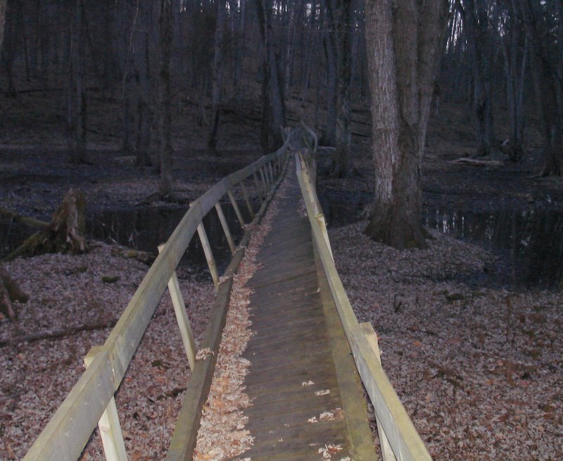
This excellent bridge at the Frink Centre was officially closed
for much of 2009. It came back into operation since then, but sometime
before fall, 2020, it was eliminated. This photo is for historical purposes only.
You can now walk over this section on the ice in winter and over the soggy marsh
in summer and fall. In the spring it's impossible. As I write this in April 2021, the creek
is a wide, deep expanse of cold water. (photo, Dec. 2008)
Foley Mountain Conservation Centre — near Westport)
Frink Centre (north of Belleville)
Durham East Cross Forest — North of Bowmanville east of Lake Scugog
Gould Lake Conservation Area (near Sydenham, north of Kingston)
Hazel Bird Nature Reserve (near Northumberland County Forest Trails)
O'Hara Mill and Conservation Area (Just west of Madoc, north of Highway #7)
Rock Dunder (Not actually conservation authority land. Belongs to the RWLT, the Rideau Waterway Land Trust)
Vanderwater Conservation Area (Thomasburg, between Tweed and Belleville)
Back to the main vishwawalking page
Page
created: February 3, 2009
Updated: September 9, 2021
Updated: September 9, 2021