About Us
Vishwawalking explained
 Ratings Explained
Vishwawalks
Day walks
Food
Funky Places
Future walks
Gear and Health
Get Lost
Good reads
Links
Plants - Animals
Right to Ramble
Site map
Contact us
Vishwawalking
Foley Mountain Conservation Area
Map of trail and waypoints on Google Maps
This conservation area has about fifteen kilometres of trails, all broken into sections or loops. At a
couple of spots in the park, you can find a hard copy of a glossy map showing all the trails. See below for my GPS mapping of the trails.
There are seven trails here plus the The Rideau Trail which passes through the park, linking many of the trails.
The longest is three kilometres, so you'll have to link two or three trails together to get a substantial walk. The shortest trail (0.1 kilometres) is really only an access to the lakeshore.
The park is perched on the mountain just to the north of Westport (this is the village' website), a beautiful historical and tourist town tucked between Westport Sand Lake (sometimes known as Westport Pond) and the much larger Upper Rideau Lake. If you decide to visit the park, it's worth scheduling a stroll around Westport as part of a day's walking.
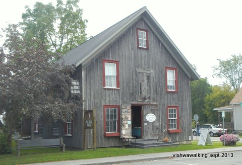 The Rideau District Museum
is an excellent little museum at 29 Bedford Street in Westport. It is
located in a building from the 1850s that once housed a blackmith and a
coffin-maker's shop. In a back corner is a beautiful sad little
coffin for a child.
More happy displays include an exquisite Victorian-style doll house built in the 1980s and "Sally Grant," an 11-foot statue of justice (complete with balancing scales) that sat on the County Court House in Brockville until 1956. Now she sits at the back of the museum away from wind and weather.
There's a donation jar near the entrance.
The Rideau District Museum: a fine, friendly place to visit, with lots of interesting
artefacts crammed into a small space. September, 2013
After you've strolled through town, drive to Main Street which runs along the waterfront. Turn left (north) and drive between the two lakes and up the mountain along County Road #10. About 900 metres from the bridge, Grady Road runs off to the right; the park road is immediately south at the same junction. You'll see the wooden sign for the park.
It costs $7.00 per car to enter the park (or $50per year). There machines just inside the park entrance that takes both coins and credit cards or you can follow direction and pay online or over the phone.
If you drive 2.3 kilometres from the entrance to the end of the park road, you'll find an interpretive centre. The park is host to a number of educational programs. You can find out more about this from the Rideau Valley Conservation Authority (who oversee the park) or from the Friends of Foley Mountain. (The latter link is certainly informative, but perhaps somewhat dated. The latest event in an "upcoming events" list a 2019 pre-covid 2019 event.)
The park is part of the Frontenac Arch Biosphere, a UNESCO-protected area. "The Frontenac Arch is the ancient granite bridge from the Canadian Shield to the Adirondack Mountains. Its incredibly rich natural environment and history was recognized in 2002 when it became a UNESCO World Biosphere Reserve, part of a world-wide network of 610 Biosphere Reserves in 117 countries." The quote is from the link above.
 Spy Rock is
a lookout, with spectacular views down to the town of Westport and the
surrounding lakes. Even if you don't have time for a walk, this is a
good place to visit. There are plenty of picnic tables sprinkled
through the park if you want to use it for a lunch spot.
For a brief description of how Spy Rock and surroundings came to be see this, amazing places. page.
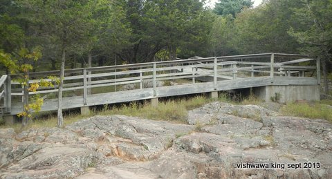
The ramp to Spy Rock looks to be wheelchair friendly. The short trail from the
parking lot to the ramp is very flat too. This picture is taken looking back from Spy
Rock. September 20, 2013
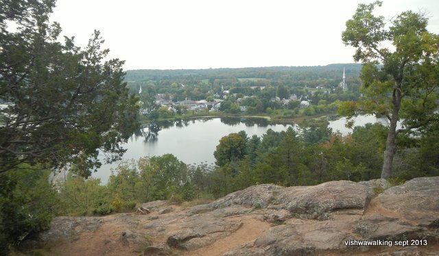
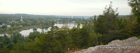
The view from Spy Rock lookout. The wooden ramp (see above) opens onto the rock and you can walk beyond the trees that
frame this picture to get a glorious view of the lakes that make up this part of the Rideau Canal as well as the town of Westport. September 20, 2013
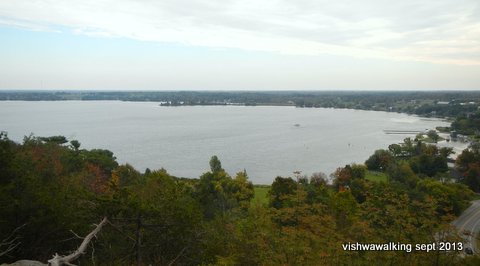
Left: The views from Spy Rock. The top picture looks east to the huge Upper Rideau Lake. To the east (lower picture) is Westport Sand Lake in the foreground with Wolfe Lake in the distance. The spire of St Edmuund's Catholic Church can be seen in the lower picture. If you were to blow this picture up, you'd also see the Free Methodist Church further off to the right and the Westport water tower.
The Spy Rock parking lot is just short of 600 metres from the entrance to the park.
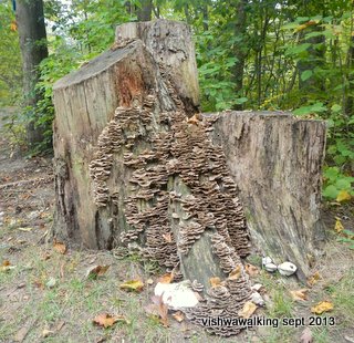
A fungus-laden stump. It was right at
Beaver Pond 1.4 kilometres.
This trail heads off from the road, shares a short section with the Blue Circle Trail, then heads off to Beaver Pond, a little lake on the west side of the park. To make a loop, you must walk for a short stretch on the road. There's a dock with open spaces at the south end of the pond that could makle for a good lunch spot.
Blue Circle Trail 3 kilometres (from Spy Rock parking lot).
The best place to start this trail is at the Spy Rock lookout. It's clearly marked, with brochures, maps, an information board and outhouses nearby.
 Head
down the trail to Spy Rock. At the boardwalk and steps down to the
rock, head to your right (west) as you face the steps if you want to travel clockwise. You'll see two
markers: the
blue circle with a little arrow along with the Rideau
trail triangular orange markers with yellow tips. The yellow tips
indicate you are travelling south on the latter trail. Have a look at
the
other side of a tree and you'll see solid orange markers, indicating
you are northward-bound. (You can head left as well if you want to go
counter-clockwise on the blue trail; I describe the trail going
clockwise.)
The trail winds about until you come to a junction, roughly half a kilometre down the trail. Turn right (north) here, following the blue markers. Shortly after that you cross the park road near the entrance. The trail parallels Grady Road, which you will see through the trees to your left.
The Beaver Trail also briefly joins the trail from the right, before it heads off right again to Beaver Pond. There's a flat marshy bit off to the left that the trail skirts before curving up a bit and heading eastward.
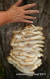
A beautiful fungus on a tree right
next to the trail. September 20, 2013
 As
the trail drops southeasterly, you will see Beaver Pond off to the
right, although the trail doesn't actually provide access to it. It
then winds over granite rocks and through mixed hardwood and softwood
forest.
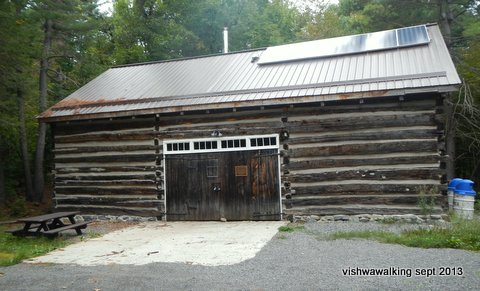
At roughly the 1.6 kilometre point, you'll see a log building through the trees. Again, there's no direct access to it; in fact there's a thin bit of rope running to the right (south) of the trail, perhaps indicating that bushwacking to the building is not advised. The building houses a museum of some sort, but was closed when I inspected it. It is accessible from the road.
There's also a roofed-in picnic area and a camping area for groups nearby. The park brochures specify that it's for "youth" groups, so I'm guessing old geezer groups need not apply.
 At
about the 2-kilometre point, the trail crosses the road. To the left, a
sideroad runs off the main road to the (on-site) supervisor's residence.
Not far from the road as the trail continues south, it joins the Red Oak Trail; make a sharp right to stay on the Blue trail. As you get closer to Spy R ock,if you parked in the Spy Rock you may see your car. To complete the trail, stay on the path (resist taking a shortcut to your car). The trail becomes slightly confusing here, but just slow down and keep an eye out for trail markers. There are a couple of blue square (not circle) markers that also might confuse; just ignore them.
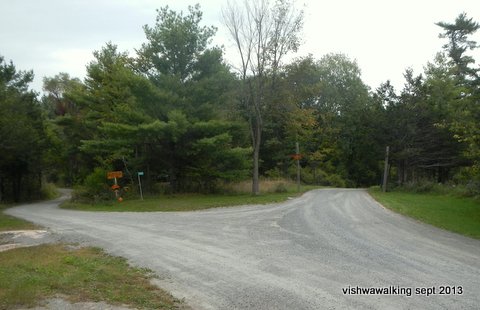
A road junction from the perspective of the trail. The trail crosses the road here.
The road to the right heads to the interpretive centre; the road to the left leads
to the park superintendent's home. September 20, 2013
Back at the Spy Rock lookout stairway, you've done the loop. Retrace your steps back to your car and you'll have walked three kilometres.
Rating:

 Easy.
Easy.
Meditation Trail 0.1 kilometres.
A short trail to the Upper Rideau Lake shore, near the Interpretive Centre. Good overview of tghe lake.
The Jack Herbert Mobility Trail 355 metres
This loop trail starts at the Interpretive Centre.
The pathway is made of smooth very-fine-gravel to allow wheelchairs and other folks who might have trouble with uneven ground. It has interpretive stops to describe natural, geological and historical features. The lake is not far off through the trees and there are lots of benches. It has ropes and other aids for those who might need them.
Orange Maple Trail (marked by a cutout of a yellow maple leaf) 2.2 kilometres
This is the westernmost loop trail in the park. Linking it with the White Pine Trail would would give you a 4.6 kilometre trail. As with most trails in this park, be careful of stones on the trail. There are a lot of rocky bits—pick up your feet! This is not to criticize. The trails are excellently maintained and genrally well marked. Be careful at some of the junctions, where most mistakes are made.
Red Oak Trail (marked by a cutout of a red oak leaf) 1.4 kilometre
Add in the blue Circle section and you have made a good loop trail. As with most of these trails (excepting the Beaver Trail) there are some steep inclines to guive you a great workout.
White Pine Trail (green) 1.2 kilometre
Add in a piece of the red oalk trail to make a good loop. If you're heading east on this trail, you'll come upon a confusing sign that asks you to go back. Ignore it. There are also white arrows pasted over the dark green arrows for this trail. I'm not sure what that is about. maybe they are for some interpretive program. Also, you'll occasionally see orange paint circles on some trees. Again, they confuse a bit, but just ignore them, you really are on the green-marked trail.
Mostly a linking trail between the Blue Circle, Red Oak and Orange Maple trails.
 Rideau Trail
3.5 kilometres (from the park entrance to the park's east
beach.
The section in the park runs along the edge of the cliff in the western part of the park, until it gets to the interpretive centre. At that point, it follows the road to the beach and then along the shore to the eastern edge of the park.
When the Rideau leaves the Orange Maple (as you head east/north) the trail erodes a bit. it's still clear and pleasant, but not maintained like other trails. at the easternmoast boundary of the park, the trail continues, but a sign warns you that you are moving onto private property.
There are seven trails here plus the The Rideau Trail which passes through the park, linking many of the trails.
The longest is three kilometres, so you'll have to link two or three trails together to get a substantial walk. The shortest trail (0.1 kilometres) is really only an access to the lakeshore.
The park is perched on the mountain just to the north of Westport (this is the village' website), a beautiful historical and tourist town tucked between Westport Sand Lake (sometimes known as Westport Pond) and the much larger Upper Rideau Lake. If you decide to visit the park, it's worth scheduling a stroll around Westport as part of a day's walking.
 The Rideau District Museum
is an excellent little museum at 29 Bedford Street in Westport. It is
located in a building from the 1850s that once housed a blackmith and a
coffin-maker's shop. In a back corner is a beautiful sad little
coffin for a child.
 More happy displays include an exquisite Victorian-style doll house built in the 1980s and "Sally Grant," an 11-foot statue of justice (complete with balancing scales) that sat on the County Court House in Brockville until 1956. Now she sits at the back of the museum away from wind and weather.
There's a donation jar near the entrance.
The Rideau District Museum: a fine, friendly place to visit, with lots of interesting
artefacts crammed into a small space. September, 2013
After you've strolled through town, drive to Main Street which runs along the waterfront. Turn left (north) and drive between the two lakes and up the mountain along County Road #10. About 900 metres from the bridge, Grady Road runs off to the right; the park road is immediately south at the same junction. You'll see the wooden sign for the park.
It costs $7.00 per car to enter the park (or $50per year). There machines just inside the park entrance that takes both coins and credit cards or you can follow direction and pay online or over the phone.
If you drive 2.3 kilometres from the entrance to the end of the park road, you'll find an interpretive centre. The park is host to a number of educational programs. You can find out more about this from the Rideau Valley Conservation Authority (who oversee the park) or from the Friends of Foley Mountain. (The latter link is certainly informative, but perhaps somewhat dated. The latest event in an "upcoming events" list a 2019 pre-covid 2019 event.)
The park is part of the Frontenac Arch Biosphere, a UNESCO-protected area. "The Frontenac Arch is the ancient granite bridge from the Canadian Shield to the Adirondack Mountains. Its incredibly rich natural environment and history was recognized in 2002 when it became a UNESCO World Biosphere Reserve, part of a world-wide network of 610 Biosphere Reserves in 117 countries." The quote is from the link above.
 Spy Rock is
a lookout, with spectacular views down to the town of Westport and the
surrounding lakes. Even if you don't have time for a walk, this is a
good place to visit. There are plenty of picnic tables sprinkled
through the park if you want to use it for a lunch spot.
Spy Rock is
a lookout, with spectacular views down to the town of Westport and the
surrounding lakes. Even if you don't have time for a walk, this is a
good place to visit. There are plenty of picnic tables sprinkled
through the park if you want to use it for a lunch spot.For a brief description of how Spy Rock and surroundings came to be see this, amazing places. page.
The ramp to Spy Rock looks to be wheelchair friendly. The short trail from the
parking lot to the ramp is very flat too. This picture is taken looking back from Spy
Rock. September 20, 2013

The view from Spy Rock lookout. The wooden ramp (see above) opens onto the rock and you can walk beyond the trees that
frame this picture to get a glorious view of the lakes that make up this part of the Rideau Canal as well as the town of Westport. September 20, 2013

Left: The views from Spy Rock. The top picture looks east to the huge Upper Rideau Lake. To the east (lower picture) is Westport Sand Lake in the foreground with Wolfe Lake in the distance. The spire of St Edmuund's Catholic Church can be seen in the lower picture. If you were to blow this picture up, you'd also see the Free Methodist Church further off to the right and the Westport water tower.


The Spy Rock parking lot is just short of 600 metres from the entrance to the park.
A fungus-laden stump. It was right at
the
edge of the parking lot as you start down the trail to
Spy Rock lookout. You can still find similar fungus
along the trails. September 20, 2013
Spy Rock lookout. You can still find similar fungus
along the trails. September 20, 2013
Beaver Pond 1.4 kilometres.
This trail heads off from the road, shares a short section with the Blue Circle Trail, then heads off to Beaver Pond, a little lake on the west side of the park. To make a loop, you must walk for a short stretch on the road. There's a dock with open spaces at the south end of the pond that could makle for a good lunch spot.
Blue Circle Trail 3 kilometres (from Spy Rock parking lot).
The best place to start this trail is at the Spy Rock lookout. It's clearly marked, with brochures, maps, an information board and outhouses nearby.
 Head
down the trail to Spy Rock. At the boardwalk and steps down to the
rock, head to your right (west) as you face the steps if you want to travel clockwise. You'll see two
markers: the
blue circle with a little arrow along with the Rideau
trail triangular orange markers with yellow tips. The yellow tips
indicate you are travelling south on the latter trail. Have a look at
the
other side of a tree and you'll see solid orange markers, indicating
you are northward-bound. (You can head left as well if you want to go
counter-clockwise on the blue trail; I describe the trail going
clockwise.)
Head
down the trail to Spy Rock. At the boardwalk and steps down to the
rock, head to your right (west) as you face the steps if you want to travel clockwise. You'll see two
markers: the
blue circle with a little arrow along with the Rideau
trail triangular orange markers with yellow tips. The yellow tips
indicate you are travelling south on the latter trail. Have a look at
the
other side of a tree and you'll see solid orange markers, indicating
you are northward-bound. (You can head left as well if you want to go
counter-clockwise on the blue trail; I describe the trail going
clockwise.)The trail winds about until you come to a junction, roughly half a kilometre down the trail. Turn right (north) here, following the blue markers. Shortly after that you cross the park road near the entrance. The trail parallels Grady Road, which you will see through the trees to your left.
The Beaver Trail also briefly joins the trail from the right, before it heads off right again to Beaver Pond. There's a flat marshy bit off to the left that the trail skirts before curving up a bit and heading eastward.
A beautiful fungus on a tree right
next to the trail. September 20, 2013
 As
the trail drops southeasterly, you will see Beaver Pond off to the
right, although the trail doesn't actually provide access to it. It
then winds over granite rocks and through mixed hardwood and softwood
forest.
As
the trail drops southeasterly, you will see Beaver Pond off to the
right, although the trail doesn't actually provide access to it. It
then winds over granite rocks and through mixed hardwood and softwood
forest.At roughly the 1.6 kilometre point, you'll see a log building through the trees. Again, there's no direct access to it; in fact there's a thin bit of rope running to the right (south) of the trail, perhaps indicating that bushwacking to the building is not advised. The building houses a museum of some sort, but was closed when I inspected it. It is accessible from the road.
The log building, accessible from the
park's road, that may house museum artifacts;
it was closed when we passed by. September 20, 2013
it was closed when we passed by. September 20, 2013
There's also a roofed-in picnic area and a camping area for groups nearby. The park brochures specify that it's for "youth" groups, so I'm guessing old geezer groups need not apply.
 At
about the 2-kilometre point, the trail crosses the road. To the left, a
sideroad runs off the main road to the (on-site) supervisor's residence.
At
about the 2-kilometre point, the trail crosses the road. To the left, a
sideroad runs off the main road to the (on-site) supervisor's residence.Not far from the road as the trail continues south, it joins the Red Oak Trail; make a sharp right to stay on the Blue trail. As you get closer to Spy R ock,if you parked in the Spy Rock you may see your car. To complete the trail, stay on the path (resist taking a shortcut to your car). The trail becomes slightly confusing here, but just slow down and keep an eye out for trail markers. There are a couple of blue square (not circle) markers that also might confuse; just ignore them.
A road junction from the perspective of the trail. The trail crosses the road here.
The road to the right heads to the interpretive centre; the road to the left leads
to the park superintendent's home. September 20, 2013
Back at the Spy Rock lookout stairway, you've done the loop. Retrace your steps back to your car and you'll have walked three kilometres.
Rating:


 Easy.
Easy.Walked: September
20, 2013
Meditation Trail 0.1 kilometres.
A short trail to the Upper Rideau Lake shore, near the Interpretive Centre. Good overview of tghe lake.
The Jack Herbert Mobility Trail 355 metres
This loop trail starts at the Interpretive Centre.
The pathway is made of smooth very-fine-gravel to allow wheelchairs and other folks who might have trouble with uneven ground. It has interpretive stops to describe natural, geological and historical features. The lake is not far off through the trees and there are lots of benches. It has ropes and other aids for those who might need them.
Walked: September
20, 2013
Orange Maple Trail (marked by a cutout of a yellow maple leaf) 2.2 kilometres
This is the westernmost loop trail in the park. Linking it with the White Pine Trail would would give you a 4.6 kilometre trail. As with most trails in this park, be careful of stones on the trail. There are a lot of rocky bits—pick up your feet! This is not to criticize. The trails are excellently maintained and genrally well marked. Be careful at some of the junctions, where most mistakes are made.
Red Oak Trail (marked by a cutout of a red oak leaf) 1.4 kilometre
Add in the blue Circle section and you have made a good loop trail. As with most of these trails (excepting the Beaver Trail) there are some steep inclines to guive you a great workout.
White Pine Trail (green) 1.2 kilometre
Add in a piece of the red oalk trail to make a good loop. If you're heading east on this trail, you'll come upon a confusing sign that asks you to go back. Ignore it. There are also white arrows pasted over the dark green arrows for this trail. I'm not sure what that is about. maybe they are for some interpretive program. Also, you'll occasionally see orange paint circles on some trees. Again, they confuse a bit, but just ignore them, you really are on the green-marked trail.
Mostly a linking trail between the Blue Circle, Red Oak and Orange Maple trails.
 Rideau Trail
3.5 kilometres (from the park entrance to the park's east
beach.
Rideau Trail
3.5 kilometres (from the park entrance to the park's east
beach.The section in the park runs along the edge of the cliff in the western part of the park, until it gets to the interpretive centre. At that point, it follows the road to the beach and then along the shore to the eastern edge of the park.
When the Rideau leaves the Orange Maple (as you head east/north) the trail erodes a bit. it's still clear and pleasant, but not maintained like other trails. at the easternmoast boundary of the park, the trail continues, but a sign warns you that you are moving onto private property.
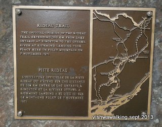
This plaque, situated behind the
interpretive centre, reads:
"The official opening of the Rideau Trail extending 300 KM
from Lake Ontario at Kingston to the Ottawa River at Richmond
Landing took place here on Foley Mountain on 7 November, 1971."
September 20, 2013
"The official opening of the Rideau Trail extending 300 KM
from Lake Ontario at Kingston to the Ottawa River at Richmond
Landing took place here on Foley Mountain on 7 November, 1971."
September 20, 2013
Home
| Contact
Us
| Site
Map
Page created:
September 21, 2013
Last walked: June 7, 2021
Updated: June 9, 2021
Last walked: June 7, 2021
Updated: June 9, 2021