About Us
Vishwawalking explained
 Ratings Explained
Vishwawalks
Day walks
Food
Funky Places
Future walks
Gear
Get Lost
Good reads
Links
Right to Ramble
Site map
Contact us
Vishwawalking
Gould Lake Conservation Area
Maps
*** Scroll down to get to my mapping of the actual trails on Google maps. ***
How to get there:
From Kingston, drive north on
Sydenham Road at Highway #401. It's roughly 18 kilometres to Sydenham.
Sydenham Road
ends in a "T" intersection at Rutledge; turn left (west) for just short
of two kilometres, where you'll meet the Rutledge Road intersection and
Mill Street.
From Rutledge and Mill: Take Mill Street north, stay north as you blend into George, and then take a right at Portland Avenue (the "T" intersection with the grocery store on your right.) You'll also cross the Cataraqui Trail here; you can see it heading east over the north shore of Sydenham Lake. (So far, less than a kilometre.)
From Rutledge and Mill: Take Mill Street north, stay north as you blend into George, and then take a right at Portland Avenue (the "T" intersection with the grocery store on your right.) You'll also cross the Cataraqui Trail here; you can see it heading east over the north shore of Sydenham Lake. (So far, less than a kilometre.)

Follow Portland around (it winds a bit). It will turn into Bedford Road (County Road #19). Continue until you get to Freeman Road (4 kilometres). Turn left and drive just over 2 kilometres to Gould Lake Road where you will turn right and curve around until you reach the Gould Lake gates (8.4 kilometres from town).
By the way, one of my maps indicates Gould Lake Road curves up and around Knowlton Lake. It doesn't. The road turns sharply right at one point. It's very clear and you'll have no trouble if you follow the main road. From the gate it's a short jaunt to the little shack where you'll pay an entrance fee and carry on to the parking lot.
Total: 10.2 kilometres from Sydenham (Rutledge and Mill) to the park's parking lot . Total from Kingston: 28.2 kilometres.
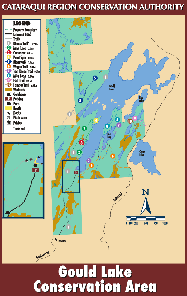
This map is from the Conservation Authority's site.
It abbreviates the getting there part nicely.

This is a Google map I have made of the trails. You can zoom in on the image, or click the link below the image to get a larger image.
Strangely, Google does not name lakes. The big lake is obviously Gould Lake. Wagon and Famous trails come out on Bedford Road just west of Cronk Lake.
View Gould Lake Conservation Area in a larger map
The map below is a colour version of the brochure you can get at the gate when you pay to enter. I got it in July, 2009, but it's still being used in 2013.
Page
created: July 31, 2009
Update: January 3, 2013
Update: January 3, 2013