About Us
Vishwawalking explained
 Ratings Explained
Vishwawalks
Day walks
Food
Funky Places
Future walks
Gear and Health
Get Lost
Good reads
Links
Plants - Animals
Right to Ramble
Site map
Contact us
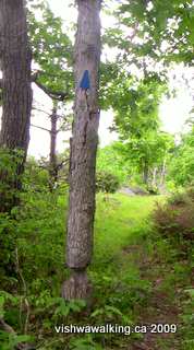
The
Ridgewalk. Notice the work the beavers have done on the tree with the
blue Rideau trail sign. This trail sometimes moves through
thicker hardwood forest, so the grassy trail here might be a bit
deceptive. However, the variety is what makes this a stellar walk.
Vishwawalking
Gould Lake Conservation Area
MapsThe
Gould lake Conservation Area is north of Kingston in Eastern Ontario
and just north of Sydenham. It's south of Frontenac Provincial Park.
Click on the link above for maps and more detailed directions. The area sports 589 hectares (1,455 acres) of wilderness.
Entrance fees are $5.50 for adults, and $3.00 for children, with a maximum of $14 per car (as of 2013).
Entrance fees are $5.50 for adults, and $3.00 for children, with a maximum of $14 per car (as of 2013).
 The
trails in the Gould Lake Conservation Area are maintained mostly by the
Rideau Trail Association. The trails are some of the
finest you'll find
anywhere.
The
trails in the Gould Lake Conservation Area are maintained mostly by the
Rideau Trail Association. The trails are some of the
finest you'll find
anywhere.They can be a challenge; they're not a Sunday stroll. The area is on the southern fringe of the Canadian Shield and the park features a number of beautiful high ridges overlooking Gould Lake. Trails often climb a steep ridge, follow it for a while then drop down into a marshy area or to the water's edge. Old mica mines next to some trails add a unique touch.
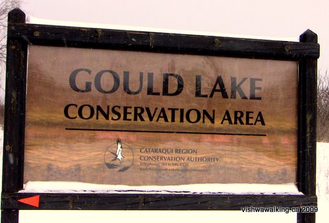
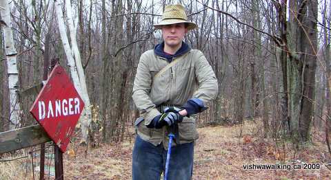
Sign at the park's front gate. Photo: February 20, 2009
What is today the park was a centre for mica mining in the second half of the nineteenth century. The MacClatchey mine, which was situated between Gould and Blue Lakes (near the Mica Loop), was mined first for phosphate and then for mica. It was abandoned in 1912 because water had seeped from the lake into the mine.
"The main shaft was over 100 feet deep, and opened out to a chamber 8 feet by 30 feet. On the property were a boarding house, trimming-shed, stable, forge, and other buildings. No power machinery was used, and hoisting from the pits was done by a horse-derrick and whims" (From a Cataraqui Region Conservation Authority website page).
Look for bits of mica on the pathways near the mine holes.
|
Phosphate and mica: what are they?
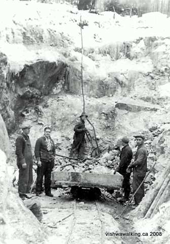 Phosphate is an inorganic chemical. " In 2007, at the current rate of consumption, the supply of phosphorus was estimated to run out in 345 years. However, scientists are now claiming that a 'Peak Phosphorus' will occur in 30 years and that 'At current rates, reserves will be depleted in the next 50 to 100 years'" (quoted in a Wikipedia piece, which has references for the information quoted. See the Mobjectivist for a fascinating and more detailed analysis of how much phosphorous we have left in this world). Mica is found in rock and "sheet" form. You'll see both around Gould Lake. Mica has excellent chemical stability and is resistant to heat. It is used in electrical application and as an insulator.it can be pressed into sheets. It is also used in such products as toothpaste and cosmetics . Apparently India has the largest deposits of mica in the world.. This photo was found at Community Voices. It depicts the Purdy mica mine in Mattawa Twp. (near North Bay) in the 1940s (Northern Development and mines photo). At Gould Lake you'll see a number of holes made to mine mica. On the Mica Loop, I didn't see any smaller holes such as you can see in the Mine Loop, but in retrospect, after looking at this picture, perhaps some of the gullys I walked through were once mines. |
Between 1967 and 1972, the Cataraqui Region Conservation Authority (CRCA) bought land from what was then Loughborough Township and from private landowners to make up what the park is today.
The CRCA is now vamping up entrance to the park. It's now (in 2013) $5.50 per person to get in, $3 for children 12 and under, with a maximum of $14.00 per vehicle. There are back entrances to the park from the trails that enter/exit on Bedford Road.
Parking inside the park is on the right at the end of the road just before you get to the "barn." The barn is on the right as you walk across an open field down to the little beach.
The field is a great place to spend a summer day hanging out. Park visitors bring barbecues and there's usually a few kids playing in the water by the beach, which has a nice bit of sand mixed, with that good old squishy lake mud as you get a bit into the water. There's a little ring of rope with floaters on it defining the swimming area for kids. The lake bottom drops off relatively quickly, so plan accordingly if you have kids.
In the winter, there are often school groups using the park and in the summer, day camps operate for kids of various ages.
There are a few picnic tables in the field, some barbecue spots and a fire pit. Although there are a few trees on the periphery of the lawn of the field, there are not a lot, so you may want to bring some sun protection.
Outhouses are at the western edge of the field. There may be running water in the barn, but I noticed no access to drinking water.
You can call the CRCA office at (613) 546-4228 ext. 222 for more information.
Once you are on the trails, there is not much in the way of beaches (the Rideau Trail guidebook mentions a beach on the Tom Dixon Trail, but it's small and not really a good stopping place), but there are plenty of fine rock outcrops where you can swim. These will give you more privacy, of course, and you have the joy of picking your very own spot.
The Trails
Concerning numbering of the trails, I've follow the Cataraqui Region Conservation Authority (CRCA) brochure, which you can get when you enter the park..1. See the Rideau Trail for a detailed description of the 8.5 kilometres of trail which goes through the park. The CRCA brochure lists this as 6.2 kilometres, but I've included a little bit of the trail to the north, which is outside of the park and connects the trail to Bedford Road
The Ridgewalk and the Mine Loop are direct offshoots of the Rideau trail, so if you want to walk them you should check out my description of this section in the link above.
2. Mine Loop, 3. Crossover Trail and 4. the Point Spur
Total: 2.7 kilometres.The loop only is 2.1 kilometres, but I've included the connecting bit (the brochure number "3. Crossover" which equals 300 metres) and the 280-metre "4. Point Spur").
From the main park area (the "barn") head up the Rideau Trail to Frog Junction just after the bridge at the Marion Webb Boardwalk. Turn right at the junction and follow the Rideau Trail's blue triangles.
(There is a trail that heads off to the extreme right along the shore. It leads to the old bridge not far north of the new bridge. If you follow this trail remnant, you can see the remains of the old bridge a the water's edge, and directly across the water, are other bits.)
 The
trail leads up the hill and slightly away from the water, then settles
down through some great open hardwood forest to following the water's
edge. It passes the crossover junction (400 metres in), then rises to
give you a fine view of the lake on a ridge at the 800 metre point. The
trail meets the Point Spur (1.1 kilometres) and heads to
the left of the latter. However, the Point spur is worth investigating.
The
trail leads up the hill and slightly away from the water, then settles
down through some great open hardwood forest to following the water's
edge. It passes the crossover junction (400 metres in), then rises to
give you a fine view of the lake on a ridge at the 800 metre point. The
trail meets the Point Spur (1.1 kilometres) and heads to
the left of the latter. However, the Point spur is worth investigating.You'll get some excellent views of the lake all along the Point Spur.
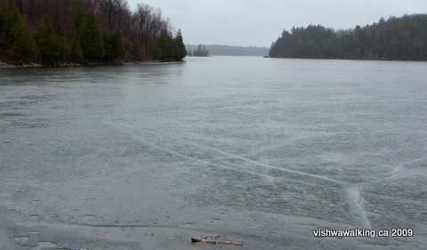
Looking north from a point along the Point Spur, which heads north off the Mine
Loop. This was a drizzly wet April 1, with the ice still hanging in on the lake. We took
refuge under some trees and in the lee of a rock overhang, where we stood and had lunch
and watched the lake, mystical in its coldness and stillness. We guessed we were the only souls
foolhardy enough to venture out on this day. It was well worth getting a little damp. Lunch was especially
good that day: Hummus and baby pita. Mapledale cheddar. Cider. An orange mixed with a quick shot of whiskey
to stem the cold. Luxury, mate, pure luxury. April 1, 2009
 On the way back, you'll run into a couple of mica mines. One is particularly large and is fenced off.
At one point the trail opens somewhat as it follows an old mine road. At the 2-kilometre point, it meets the other end of the crossover trail, then moves on to Hill Junction, back at the main Rideau Trail.
From here, it's just under 250 metres left (south) to Frog Junction along the main Rideau Trail
My walking companion poses in front of the sign on the fence surrounding one
of the mine holes on the Mine Loop. The straw hat is in open defiance of the
early April weather; it was more winter/spring than summer. April 1, 2009
of the mine holes on the Mine Loop. The straw hat is in open defiance of the
early April weather; it was more winter/spring than summer. April 1, 2009
Rating: Easy-moderate.
Easy-moderate.Walked: April 1, 2009
5. Ridgewalk
Total: 1.8 kilometres (the brochure calls it at 1.4, kilometres, the Rideau Trail lists it at 1.8).
 This
trail branches off the Rideau Trail at Brook Junction, 1.7 kilometres
from Frog Junction. You can use it as either an alternative to the main
trail or as a loop if you are doing a day trip from the Gould lake
parking lot or coming south from Bedford Road.
This
trail branches off the Rideau Trail at Brook Junction, 1.7 kilometres
from Frog Junction. You can use it as either an alternative to the main
trail or as a loop if you are doing a day trip from the Gould lake
parking lot or coming south from Bedford Road.The trail runs along the ridge to the west of Gould Lake.
Watch closely for trail markers in places as the trail winds along.
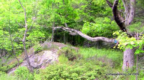
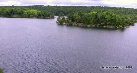
These kinds of views are familiar along the Ridgewalk as the trail moves from a
more open section of the ridge, then plunges back into the forest. June 3, 2009
 The trail rises from Brook Junction to a grassy ridge, then drops to skirt a marsh on the left .
It rises again to the ridge and nearing the northern junction with the trail drops once more to negotiate a little creek.
On some maps marshes are indicated near the Ridgewalk. Some of them (as above)
are more like ponds or little lakes.
are more like ponds or little lakes.
Rating: Moderate.
Moderate.Walked: June 3, 2009
6. Wagon Trail
Total: 2.4 kilometres
 You
can get to this trail from the back of the park's parking lot. If you
want to do it west to east from Bedford road, the trail heads east from
the road between Shultz Lane to the south and McKercher Lane just to
the north.
You
can get to this trail from the back of the park's parking lot. If you
want to do it west to east from Bedford road, the trail heads east from
the road between Shultz Lane to the south and McKercher Lane just to
the north. From the junction of Freeman Road and Bedford Road, it is 3.8 kilometres north. You can park by the roadside.
It was once used for the mica mine operations in the area.
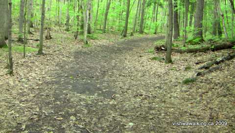
The Wagon Trail is a nice relaxed trail, winding through mature hardwood and
picturesque marshy sections. July 24, 2009
This is a good easy trail which might work for families with different walking skills. It's also open enough for cross-country skiing. I have walked it in both the summer and the winter.
Heading from the parking lot, the double-tracked trail winds up and around marshes. The trail moves through mature stands of hardwood trees early on. They're impressive
There are two crossover points to get you over to the Tom Dixon Trail to the east if you want to do this as a loop. The first branches off just before you cross a bridge. The second is signposted well at Porky Junction. (However, read the Tom Dixon Trail description below before you consider the loop idea: it's a very different level and may intimidate some.)
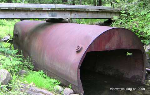 At the bridge, have a look at what might be a
boiler supporting the bridge itself. One website mentioned a boiler
somewhere beside the Mica Trail. I never saw it (and I was
looking). However, perhaps this is the boiler referred to.
At the bridge, have a look at what might be a
boiler supporting the bridge itself. One website mentioned a boiler
somewhere beside the Mica Trail. I never saw it (and I was
looking). However, perhaps this is the boiler referred to.The creek flows from Gould Lake into a couple of smaller lakes before emptying into Little Long Lake to the east.
This is the same creek as the one that flows under the Tom Dixon Trail bridge (see photos and description below).
This bridge, just east of a junction on the Wagon Trail that leads to the Tom Dixon
Trail, features an old boiler (at least that's what I'm guessing it was). July 24, 2009
From the bridge it's an easy 1.6 kilometres to the road, passing the aforementioned Porky Junction along the way.Trail, features an old boiler (at least that's what I'm guessing it was). July 24, 2009
If you drive Bedford Road, as you pass Little Long Lake (on your right as you head north), notice the little creek that passes under the road on its way to the lake. It's the same creek you walked over on the Wagon Trail and the Tom Dixon Trail. That's what I love about this walking gig: it's like putting the pieces of a jigsaw together, getting to understand the geography of the world we live in.
Rating:
Easy.Walked: July 24, 26, 2009
7.Tom
DixonTotal: 3.2 kilometres
This is a fantastic trail, but be warned: it traverses steep ridges and will give you a good workout. Tackle it only if you are confident of your hiking skills. It follows the eastern edge of Gould Lake.
I have counted a bit of trail that starts on the south side of the Miriam Webb boardwalk/bridge and follows the edge of Gould Lake to the main picnic area. If you start there, you come out at the beach near the canoe storage area. You'll pass the cement foundations of an old building just before you reach the beach area.
The trail then follows a little boardwalk on the opposite side of the beach below the barn. As it curves northward, following the shore, you'll soon get a taste of the steep ridges.
At just over a kilometre from the barn, you'll come upon an open spot with a trail heading east away from the lake. That's a short connecting bit that rejoins the Tom Dixon Trail, cutting off the point loop. Another trail heads south and is a connecting link to the Wagon Trail. It meets the latter at a bridge with an old metal boiler supporting it (see the Wagon trail description).
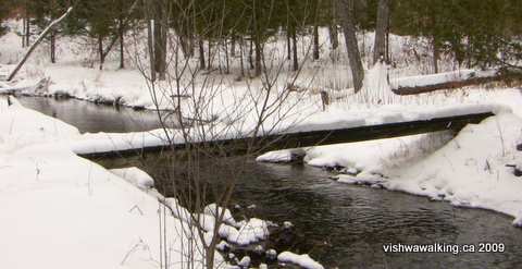 Continuing along the lakeshore, the trail loops up and around the point,
arriving at a little bridge (see pictures below). The connecting link
described above comes in from your right. Cross the bridge and
continue your northward trek.
Continuing along the lakeshore, the trail loops up and around the point,
arriving at a little bridge (see pictures below). The connecting link
described above comes in from your right. Cross the bridge and
continue your northward trek.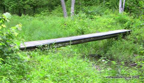
At the 2-kilometre point from the barn, there is a second short crossover trail that leads you east to Porky Junction and the Wagon Trail."Note a stand of mature large-tooth aspen adjacent to a mica pit," says the 2006 guide book (p. 34). I didn't read the Rideau Trail guidebook before I walked the trail and missed both.
At points here, you'll be walking high on a ridge overlooking the lake. This is, as a glance at the map will show, is actually a little bay or harbour with two spits of land protecting it.
Two views of the bridge on the Tom Dixon Trail in different seasons.
(Photos: Top: January 23, 2009; Bottom: July 24, 2009)
As you near the northern part of the "harbour" (about 2.5 kilometres from the barn), you'll see an "unofficial" trail crossover dropping sharply off the cliff. You can take this if you want to cut out a more relaxed and safer little loop that eases you down the slope. Be careful if you take this option.
 Just
past this point, the trail passes by a great open spot with just enough
trees to protect you from the sun, open enough for a little breeze and
some big flat rocks to relax and have a picnic. When I walked this bit
in July, some summer camp folk had stopped here and were playing games.
They had paddled in.
Just
past this point, the trail passes by a great open spot with just enough
trees to protect you from the sun, open enough for a little breeze and
some big flat rocks to relax and have a picnic. When I walked this bit
in July, some summer camp folk had stopped here and were playing games.
They had paddled in.The trail curves right at this point and continues to follow the water's edge.
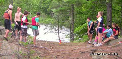
Members of a summer camp play a game at a stop along the Tom Dixon Trail.
They had paddled in. This is a fine place for a picnic, in a bay protected from the
larger lake. July 26, 2009
They had paddled in. This is a fine place for a picnic, in a bay protected from the
larger lake. July 26, 2009
At 2.7 kilometres from the barn, the trail meets the southern junction of the Mica Trail. It then goes through an impressive gully for short distance before the Tom Dixon Trail ends at Mica Junction. The Mica Trail heads west up an incline and the East Trail heads west up a steeper hill.
I have walked parts of this trail in the winter, but it would be very difficult walk the entire trail at this time of the year. Fortunately in deep winter, there is the flat ice of the lake to fall back on. In winter I have walked a mix of these trails, including a semi-bushwhacking trek along a trail cut by some high school students. On a sunny day, when exhaustion slows you down, a walk down the lake can be exhilarating. You may want snowshoes, although I plodded along in my boots.
Rating:
Strenuous. Steep ridges.
Walked: January 24 (part of the trail), July 24, 26, 2009
8.Mica Loop
Total: 2 kilometres (the CRCA brochure and the Rideau Trail call it at 2 kilometres. A sign at the northern end of the loop inextricably lists it as 3.4 kilometres; perhaps the trail was longer at one time.)
 This
is a fine trail, which you could regard as an extension of the Tom
Dixon Trail, following the lakeshore for most of its length.
This
is a fine trail, which you could regard as an extension of the Tom
Dixon Trail, following the lakeshore for most of its length.I didn't see any mica mine holes such as there are on the mine loop on the opposite side of the lake. As I mentioned elsewhere, perhaps the mines were larger and I actually walked through human-made gullies. The MacClatchey mine was here, between Blue and Gould lakes (see introduction above).
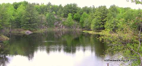
The views over Gould Lake from the Mica Loop are spectacular. The trail has
some steep ups and downs, but it's well worth the effort. July 24, 2009
There must be some trace of the mine in the bush as there were once a number of buildings associated with the mine.
There are some absolutely spectacular views of Gould Lake along sections of the trail where it borders the western shore. The northern point is a good place to stop for a rest and a picnic.
As you come down to the southern point that forms the northern side of a narrows that join a bay to the east and the main lake, there is a more open grassy section. Turtles obviously love it here, as I found several holes ("nests"?) where turtles had broken from their shells and made for the water.
Rating:
Moderate. Walked: July 24, 2009
9. East Trail
Total: 650 metres (The CRCA and my old Rideau guidebook list this as 900 metres, but they include the part that has now been eliminated.)
East trail has been truncated from its earlier longer version that extended to Bedford Road, probably because of private property issues. There are hints on Bedford Road as to where the old trail came out and private property signs nearby.
Trail makers are so at the mercy of private property owners, largely because our culture, from its beginnings, has been built upon the theft of land from those who know it can't really be so individually owned.
I have had my share of indignation from landowners who feel they have been violated by people walking upon their acreage
I try to balance that with the many generous landowners who are more civilized in their approach to the land they oversee.
 As it
stands today, the trail starts at the northern junction of the Mica
Loop and the Tom Dixon Trail. It winds up and down, passing by the end
of Famous Trail less than 200 metres along, then looping by Blue
Lake (on the left) and a marsh, crossing Stinky Creek before it cuts sharply right, then meets
and ends at Famous Trail.
As it
stands today, the trail starts at the northern junction of the Mica
Loop and the Tom Dixon Trail. It winds up and down, passing by the end
of Famous Trail less than 200 metres along, then looping by Blue
Lake (on the left) and a marsh, crossing Stinky Creek before it cuts sharply right, then meets
and ends at Famous Trail.As it's so short, it's best combined to make loops with Famous Trail and the Tom Dixon Trail. It's got some good rugged bits. I saw a huge buck along this trail, which I disturbed as he was drinking from one of the marshes.
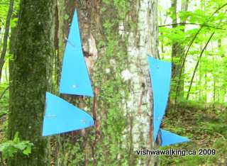
Signs at the meeting of Famous trail and one
end of East Trail. Looking west, the top left triangle
indicates straight on for the Famous Trail. The bottom
left indicates turn right for East Trail. Moving around the
tree, the triangle pointing down means the end of East Trail,
which is coming in from that direction. The triangle peeking in
from the bottom right tells eastbound walkers they can turn left to
take the east Trail. A final triangle, out of sight tells eastbound walkers
they can continue straight on the Famous Trail. Got that? July 22, 2009
Rating:
Moderate.Walked: July 22, 2009
10. Famous Trail
Total: 1 kilometre. (Everyone's in agreement here.)
There's a little boardwalk by the road that gets you over the ditch, followed by a steep incline. The trail winds about avoiding marshy areas. There are also a lot of steep ups and downs to negotiate. At the 600-metre point, the East Trail comes in from the right. A bit farther on, it crosses what the guidebook calls Stinky Creek.
The trail then winds on a bit farther, ending where it meets East Trail once more as the trail opens to a grassy spot.
Rating:
Moderate.Walked: July 22, 2009
Page
created: February 3, 2009
Updated: June 26, 2013
Updated: June 26, 2013