About Us
Vishwawalking explained
 Ratings Explained
Vishwawalks
Day walks
Funky Places
Future walks
Food
Gear
Get Lost
Good reads
Links
Right to Ramble
Site map
Contact us
The H. R. Frink Conservation Area and Outdoor Education Centre
381 Thrasher Rd, 2km east of Hwy #37
How to get there: Highway #37 heads north out of Belleville from Highway #401. Heading north, after about nine kilometres take a right turn at Thrasher Road, which angles north-east. The Frink Centre is at 381 Thrasher Road, about two kilometres from #37. There is a small parking lot on the east side of the road. I recommend parking here unless you are sure the gates to the north side will still be open when you return. The west lot, however, is roomier. There is also a parking lot on the east side back towards #37 about a kilometre, where the Cross Country Trail meets the road.
The Frink Centre offers a number of short walks; in fact, you could do all the walks at Frink in one day. The centre has 13 kilometres of trails.
Trails are clear, and generally easy. The complex of trails, however, is somewhat confusing, so it's best to take some kind of map. Except for a drumlin near the river, most trails are in the lowlands and often pass through marshy areas. This is one of their main attractions. The Frink Centre site (see above link), which is actually part of the Hastings and Prince Edward District School Board web pages, gives brief descriptions of each trail by name and distances.
A number of boardwalks make these trails very pleasant. In wet weather watch out — they can be slippy. While Frink is very child friendly, cavorting on wet boardwalks could be dangerous. A few parts of the trails are in disrepair (although not nearly so bad as some conservation areas).
I've written about tight funding elsewhere, but trail degenerations is part of provincial starving of money to municipalities. The Frink Centre is always hungry for maintenance funds. It has a Friends of Frink organization that helps to offset that.
In past years, the local board of education, which supports it and uses it extensively for outdoors programs, have made noises about having to cut funds, etc. However, the Frink survived the Harris debacle in the 1990s (a backward right-wing Ontario premier who made policies that still negatively affect the province) so one presumes they can weather anything. Not to be overly partisan, the present Liberal government was brutal to provincial parks in 2013. In 2021, the provincial Conservatives have been brutal over conservation authority funding and trail maintenance could be particularly hard hit.
But back to the centre. There's a "challenge area," used by schools, with ropes and tires and so on that's great fun. It's on the Hi-Lo Trail. There are signs warning one away and counselling supervision. The last is good advice: supervise your kids, take care, etc. etc.
The Frink Centre's "story map" is well worth investigating. It's trail map is clear and there are some fine photos.
Getting lost or turned around is easy, but if you stay on the trails, so is finding your way out. Everything eventually winds its way back to the parking lot.
The H.R. Frink Centre opened in 1972 in a joint effort between the local education board and the local conservation authority, which owns the land. On some topographic maps it is called the Plainfield Conservation Area. Herbert Frink was a well-known local educator and conservationist. Today both the public and the separate school boards support it.
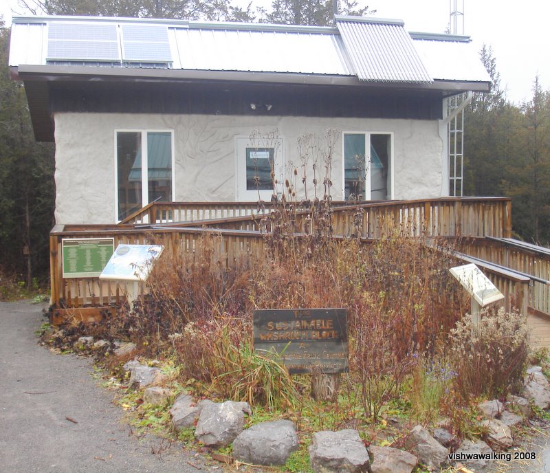 A
feature of the Frink is hay-bale-and-clay building that serves as a
bathroom facility. Off to the right as you face it is a mini
"constructed wetland." that deals with waste in an environmentally kind
way.
A
feature of the Frink is hay-bale-and-clay building that serves as a
bathroom facility. Off to the right as you face it is a mini
"constructed wetland." that deals with waste in an environmentally kind
way. The washrooms are fitted with composting toilets. Solar energy provides heat for the building, for the water system, and for its electricity needs. Wind power also helps provide electrical power.
Unfortunately, I have seldom seen the building in operation in the past few years. (I write this in August 2021.)
The "Sustainable development Site" features a straw bale house.
The Frink is situated on almost 500 acres of land; it added 100 acres to the area in March of 2009, when it purchased land for $32,000 from an adjacent landowner. It has about 13.6 kilometres of trails.
The area features a Class 1 wetland. Class 1 is the highest designation given by the Ontario Ministry of Natural Resources for what they call a Provincially Significant Wetland. That means it could have rare plants or lots of common ones and be situated in a rarer type of bog or fen. A fen is an area of land covered completely or partially with shallow water or subject to frequent flooding. The Silver Maple Swamp, which the long bridge once spanned spans on the Hi-Lo trail at the Frink Centre is my idea of a fen.
The Trails
On the West Side, going toward the river:
Drumlin Trail
1.7 kilometres, plus 275 metres in a shortcut and an extension Red markers
Walk to where the classrooms are and look to your left. You'll see where the trails begin between two buildings in the left corner where the open area ends.
Walk over the boardwalks and past the right turn to Timber and Quill/Pixie Trails. You can take the next right and walk along the south side of the drumlin past the sugar shack. You'll walk past a sugar maple swamp (which the Centre taps each spring) and through maples along the trail. The low wet area to your right is called Silver Maple Swamp. Not long past the shack, you'll come to the bridge to your right. If you stay on the Drumlin trail, you'll loop around until you come to the Moira River. Here, at the T intersection, you can head right to the point, to get a good view of the swampy bits where Park's Creek enters the Moira (just out of sight beyond the reeds), the rapids upriver towards the south end of the village of Plainfield, and a good portion of the Moira, which widens out here considerably before making a right turn back toward highway #37.
From here, retrace your steps past the T intersection (stay right) and move back along the drumlin with the river to your right, looping back to where you started. You can dip down just before the T intersection to take the Riverside Trail back, if the water is not too high.
Last walked: January, 2021
Settlers Trail
1.2 Kilometres, plus a 20 metre shortcut and an 80 metre extension Green markers
Throw in 150 metres of the Hi-Lo (Blue) trail and you have a nice loop starting at the front gate A 215 metre stretch of the Hi-Lo will get you from the gate to the start of the Settlers Trail; repeat that bit back to the gate to get a 1.63 kilometre walk.)
Last walked: January, 2021
Riverside Trail
600 metres Magenta markers
 This
is a great variation from the upper (Drumlin) trail, but it's
impossible to do in the spring and sometimes in the fall, as it is
likely to be underwater. In the spring and fall, there's a good chance
you can catch hundreds of Canada geese taking a break from their
migration. (By the way, see one of my spring southward Vishwawalks, in
which I walked down the east side of the river, across the mouth of
Park Creek, respectfully away from the actual mouth, onto Riverside
Trail. This is not recommended unless the ice is thick.)
This
is a great variation from the upper (Drumlin) trail, but it's
impossible to do in the spring and sometimes in the fall, as it is
likely to be underwater. In the spring and fall, there's a good chance
you can catch hundreds of Canada geese taking a break from their
migration. (By the way, see one of my spring southward Vishwawalks, in
which I walked down the east side of the river, across the mouth of
Park Creek, respectfully away from the actual mouth, onto Riverside
Trail. This is not recommended unless the ice is thick.)Unfortunately, as the water in this section of the Moira slows drastically and backs up here, it's also a favourite collecting place for bottles and other junk yahoos have thrown away.
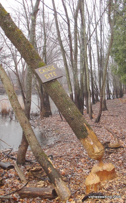
The beaver have been at work here, and apparently object to the canoe site (see photo left). There are also duck bird houses here for Wood ducks.
This sign, from 2008, no longer exists. The freshly-gnawed
tree shown here is now rotting back to the earth. Photo: 2008
Last walked: February, 2021
Hi-Lo Trail
1 kilometre Blue
Last walked: February, 2021
Pine
310 metres (really just an extension of the Hi-Lo Trail)
Last walked: February, 2021
Quill Trail
515 metres Orange markers
Last walked: February, 2021
Pixie Trail
350 metres Yellow markers
Last walked: February, 2021
Cedar Creek365 metres Double black line on Friends' map; no markings on the trail. This is one of my favourite trails in the park, but it's been neglected over the years. It ends in a little viewing platform that leans more toward the creek every year.
Last walked: February,2021
Timber Trail300 metres Brown markers
Last walked: February, 2021
On the east side of the road, away from the river:
Boardwalk Trail
530 metres
Last Walked: March, 2021
The Boundary Trail2.3 kilometres Red markers
Last walked: February 15, 2021
Horsetail Trail
450 metres Blue markers
Last walked: February, 2021
Pond Trail
215 metres
Last walked: February, 2021
Link Trail
175 metres
Last walked: February, 2021
The Boardwalk
(.9 kilometres — Friends' estimate). This is an easily accessible walk from the parking lot. It allows for good views as you stroll accross the boardwalk that straddles the pond.
(.9 kilometres — Friends' estimate). This is an easily accessible walk from the parking lot. It allows for good views as you stroll accross the boardwalk that straddles the pond.
Last walked: February, 2021
Cross Country Trail
1.8 kilometres total: 1.3 from the boardwalk around the outer trail, plus 500 metres of shortcuts and alternate routes.
Last walked: February, 2021
Overall rating of all trails:
Easy. Trails vary in upkeep, from very good close to the centre itself, to more neglected further out. The Cedar trail, for example, is not well maintained, but is still my favourite in the park. Because the centre gets school board funding and is a focus of outdoor education, it is a favoured park among conservation centres and so does much better overall than many other conservation parks.
I question some of the listed lengths of trails. I'm sure my own calculations can do with some improvements, but I'm gambling that my numbers are closer than the Friends' map calculations.
I could not have done this without the Friends' work on the trails in the last few years. I'm sure it took many hours to organize efforts. When I wrote about Frink many years ago, I was forced to make my own decisions as to how the trails were organized. Today that's not the case. Thanks to those who have worked and are working to make things easier for walkers!
Links:
My maps of the trails on Google Maps.
Home
| Contact Us
| Site
Map
Page
created: February 3, 2009
All trails last walked: January, March 2021
Updated: August 6, 2021
All trails last walked: January, March 2021
Updated: August 6, 2021