About Us
Vishwawalking explained
 Ratings Explained
Vishwawalks
Day walks
Funky Places
Future walks
Food
Gear
Get Lost
Right to Ramble
Good reads
Site map
Links
Contact us
4) Madoc Junction
to the Ridge Road (County Road #8)
Total: 6.7 kilometres
Running total: 27 kilometres
 From
the junction the trail curves north-westward. In fact, the trail gently
curves much of the way to County Road #8. After you pass the
wooded pasture and the windmill on the left, the trail moves into a
wooded section and crosses a little bridge. When I walked the trail in
July, the creek running under the bridge had entirely dried up. These
little streams are tributaries of Rawdon Creek, which follows the Trail of Two Lakes for much of it's southern length. A pasture/meadow opens up to the left where the creek runs.
From
the junction the trail curves north-westward. In fact, the trail gently
curves much of the way to County Road #8. After you pass the
wooded pasture and the windmill on the left, the trail moves into a
wooded section and crosses a little bridge. When I walked the trail in
July, the creek running under the bridge had entirely dried up. These
little streams are tributaries of Rawdon Creek, which follows the Trail of Two Lakes for much of it's southern length. A pasture/meadow opens up to the left where the creek runs.
 Some parts of the trail (particularly closer to Stirling) are like a
roller coaster, with ATV-created dips and high spots. It's a pain for
bicyclists.
Some parts of the trail (particularly closer to Stirling) are like a
roller coaster, with ATV-created dips and high spots. It's a pain for
bicyclists.
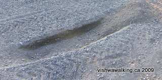
Watch for holes. Near Madoc Junction, an ATV had spun its wheels, creating a huge hole in the trail. Also, at Madoc Junction, ATVs have spun around the corner from one trail to the next, creating a big dip and corresponding high spot.
An ATV spinning its wheels creates this dip and a high
spot behind.
Speaking of destruction, I passed two chipmunks within 200 yards of each other on this section. They had failed to look both ways and had paid the ultimate price.
Behind a row of pine trees in one of the marshes, a pair of Osprey were making a huge racket and performing a fantastic dance in their nest. A mating ritual? I wasn't sure, but the performance was magnificent. I tried to get a video of it, but the deer flies were so thick, I couldn't keep the camera still for more than a couple of seconds.
 A third bridge spans
the Rawdon Creek as it meanders under the trail.
A third bridge spans
the Rawdon Creek as it meanders under the trail.
Deer flies are a concern on many trails in this area at this time of the year. If they bother you unduly, make sure you protect yourself with chemicals and netting.
Mosquitoes are bad in July in swampy sections ,particularly in the early evening .
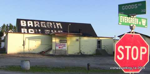
The trail moves through corn and bean fields to the intersection of Goods and Evergreen roads. The Stirling Surplus store is situated here.
I haven't been into it since it was called "Bargain Bailey's" but if it's the same kind of store, it's worth wandering through just to gawk at the strange merchandise.
After crossing the roads, it's 2.2 kilometres to County Road #8, past fields, swamp and a horse farm. The swamp was buzzing with activity when I passed: a flock of ducks a family of ducks, a beaver cruising about and lots of smaller songbirds.
Just before County Road #8, a fourth bridge crosses Rawdon creek and there is a pretty view of the Creek on its west side. A ridiculous sign welcoming ATVs to Stirling appears just before the road. The trail angles west at this point.
Rating: Easy.
Total: 6.7 kilometres
Running total: 27 kilometres
From
the junction the trail curves north-westward. In fact, the trail gently
curves much of the way to County Road #8. After you pass the
wooded pasture and the windmill on the left, the trail moves into a
wooded section and crosses a little bridge. When I walked the trail in
July, the creek running under the bridge had entirely dried up. These
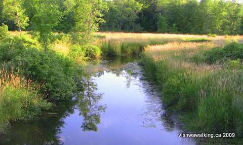
little streams are tributaries of Rawdon Creek, which follows the Trail of Two Lakes for much of it's southern length. A pasture/meadow opens up to the left where the creek runs.The view from the second bridge north of Madoc Junction, looking south over
Rawdon Creek and its marshes.
As
you move out of the woods, fields reappear and a second bridge
crosses Rawdon Creek proper. To the left (west) you'll see the marshes
that are part of Rawdon Creek. The bridges are well maintained. The
trail itself has been treated to gravel at points, presumably to shore
up wet spots. ATVs have created rolling dips and hills in some
sections, which would be a nuisance for a bicyclist.Rawdon Creek and its marshes.
T
.
.
Some parts of the trail (particularly closer to Stirling) are like a
roller coaster, with ATV-created dips and high spots. It's a pain for
bicyclists.Watch for holes. Near Madoc Junction, an ATV had spun its wheels, creating a huge hole in the trail. Also, at Madoc Junction, ATVs have spun around the corner from one trail to the next, creating a big dip and corresponding high spot.
An ATV spinning its wheels creates this dip and a high
spot behind.
Speaking of destruction, I passed two chipmunks within 200 yards of each other on this section. They had failed to look both ways and had paid the ultimate price.
Behind a row of pine trees in one of the marshes, a pair of Osprey were making a huge racket and performing a fantastic dance in their nest. A mating ritual? I wasn't sure, but the performance was magnificent. I tried to get a video of it, but the deer flies were so thick, I couldn't keep the camera still for more than a couple of seconds.
A third bridge spans
the Rawdon Creek as it meanders under the trail.Deer flies are a concern on many trails in this area at this time of the year. If they bother you unduly, make sure you protect yourself with chemicals and netting.
Mosquitoes are bad in July in swampy sections ,particularly in the early evening .
The Stirling Surplus store at Goods and Evergreen roads. It was once known as
Bargain Bailey's and had an eclectic stock at, well, bargain prices.
Bargain Bailey's and had an eclectic stock at, well, bargain prices.
The trail moves through corn and bean fields to the intersection of Goods and Evergreen roads. The Stirling Surplus store is situated here.
I haven't been into it since it was called "Bargain Bailey's" but if it's the same kind of store, it's worth wandering through just to gawk at the strange merchandise.
After crossing the roads, it's 2.2 kilometres to County Road #8, past fields, swamp and a horse farm. The swamp was buzzing with activity when I passed: a flock of ducks a family of ducks, a beaver cruising about and lots of smaller songbirds.
Just before County Road #8, a fourth bridge crosses Rawdon creek and there is a pretty view of the Creek on its west side. A ridiculous sign welcoming ATVs to Stirling appears just before the road. The trail angles west at this point.
Rating:
Easy.Walked: July 19, 2009
5) Ridge Road (County Road #8)
east of Stirling to the junction with the Hastings Heritage Trail at Anson
Total: 5 kilometres
Running Total: 32 kilometres
 From
the Ridge Road (County Road #8), it's a nice easy stroll through
through Stirling for 2.2 kilometres until you reconnect with County
Road #8 as it jogs briefly north. The trail passes along the bottom of
people's back yards, so you get a glimpse of lawns, toys, barbecues and
the like. The bushes lining the trail give you a touch of both
rural and urban.
From
the Ridge Road (County Road #8), it's a nice easy stroll through
through Stirling for 2.2 kilometres until you reconnect with County
Road #8 as it jogs briefly north. The trail passes along the bottom of
people's back yards, so you get a glimpse of lawns, toys, barbecues and
the like. The bushes lining the trail give you a touch of both
rural and urban.
As you enter the village, a little park on the north side of the trail at William Street is a good place to rest your feet for a while.
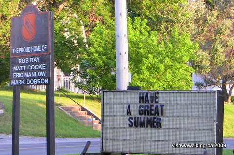
The signs on the road at the east end of Stirling, just off the trail.
Stirling is just to the south as you walk between houses, so you can always veer off to have a look at a church, go to a restaurant, or change the scenery by walking along a residential street.
At North Street (which turns into the Stirling-Marmora Road further north), the trail widens and you will come upon the old Stirling train station on the left. On the right is a fine information board giving some history about both the railroad and Stirling.
From this point on the bushes along the path largely disappear. After passing a small skateboard park on the right, this side opens mostly to fields, while the left is taken up by an elementary school yard and lots of large stretches of lawn.
 At
Campbellford Road (County Road #8), we leave the town behind. After a
barn with a bright orange door on the left are a series of industrial
buildings. From here it's a pleasant walk through woods and fields.
At
Campbellford Road (County Road #8), we leave the town behind. After a
barn with a bright orange door on the left are a series of industrial
buildings. From here it's a pleasant walk through woods and fields.
A "Come Again" sign similar to the entrance to the town is on the left, similar to one in Tweed depicting an ATV with its wheel in the air about to crush a bicyclist. Snowmobiles and ATVs are the main feature.
On the right are fields. Soon the fields end and there is a brief section of woods before the trail crosses Bedford Road. The rail bed has been shored up here with gravel, which would be tolerable but not ideal for bicycles. A beaver crossed the trail at a wet spot at one point and cattle graze in fields near the junction at Anson.
 Just
before the Anson junction, a trail curves off to the north. This is the
"off ramp" connecting the trail to the Hastings Heritage Trail.
Stay to the left, watching a couple of deep holes just after the bridge.
Just
before the Anson junction, a trail curves off to the north. This is the
"off ramp" connecting the trail to the Hastings Heritage Trail.
Stay to the left, watching a couple of deep holes just after the bridge.
The junction will appear very shortly afterwards. At this point, the Trans Canada Trail, comes in from the north sharing the the Hastings Heritage Trail. The Trans Canada links with the Grand Junction, heading west into Campbellford.
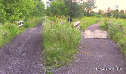
A double bridge just east of the Anson junction where the trail meets the north-south
Hastings Heritage/Trans Canada Trail and continues westward as the Trans Canada Trail
(The description of the trail from this point is identical to the Trans Canada Trail description.)
Total: 5 kilometres
Running Total: 32 kilometres
From
the Ridge Road (County Road #8), it's a nice easy stroll through
through Stirling for 2.2 kilometres until you reconnect with County
Road #8 as it jogs briefly north. The trail passes along the bottom of
people's back yards, so you get a glimpse of lawns, toys, barbecues and
the like. The bushes lining the trail give you a touch of both
rural and urban.As you enter the village, a little park on the north side of the trail at William Street is a good place to rest your feet for a while.
The signs on the road at the east end of Stirling, just off the trail.
Stirling is just to the south as you walk between houses, so you can always veer off to have a look at a church, go to a restaurant, or change the scenery by walking along a residential street.
At North Street (which turns into the Stirling-Marmora Road further north), the trail widens and you will come upon the old Stirling train station on the left. On the right is a fine information board giving some history about both the railroad and Stirling.
From this point on the bushes along the path largely disappear. After passing a small skateboard park on the right, this side opens mostly to fields, while the left is taken up by an elementary school yard and lots of large stretches of lawn.
At
Campbellford Road (County Road #8), we leave the town behind. After a
barn with a bright orange door on the left are a series of industrial
buildings. From here it's a pleasant walk through woods and fields.A "Come Again" sign similar to the entrance to the town is on the left, similar to one in Tweed depicting an ATV with its wheel in the air about to crush a bicyclist. Snowmobiles and ATVs are the main feature.
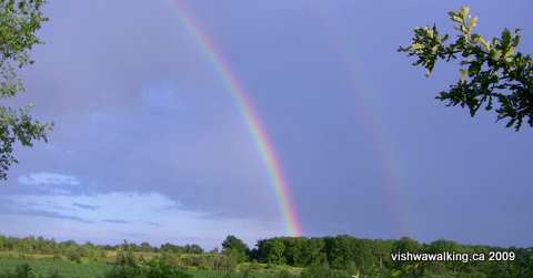
A double rainbow (the second one was fading when I took this picture) appeared during
a short rainfall just before the junction at Anson. It remained for 20 minutes or more.
a short rainfall just before the junction at Anson. It remained for 20 minutes or more.
On the right are fields. Soon the fields end and there is a brief section of woods before the trail crosses Bedford Road. The rail bed has been shored up here with gravel, which would be tolerable but not ideal for bicycles. A beaver crossed the trail at a wet spot at one point and cattle graze in fields near the junction at Anson.
Just
before the Anson junction, a trail curves off to the north. This is the
"off ramp" connecting the trail to the Hastings Heritage Trail.
Stay to the left, watching a couple of deep holes just after the bridge.The junction will appear very shortly afterwards. At this point, the Trans Canada Trail, comes in from the north sharing the the Hastings Heritage Trail. The Trans Canada links with the Grand Junction, heading west into Campbellford.
A double bridge just east of the Anson junction where the trail meets the north-south
Hastings Heritage/Trans Canada Trail and continues westward as the Trans Canada Trail
(The description of the trail from this point is identical to the Trans Canada Trail description.)
.
Rating: Easy.
1) Back to the introduction and first sections of the Grand Junction Railway trail
3) On from Anson to Campbellford
4) Campbellford to Hastings
Rating:
Easy.Walked:
July 14, 18, 2009
1) Back to the introduction and first sections of the Grand Junction Railway trail
3) On from Anson to Campbellford
4) Campbellford to Hastings
Home | Contact Us | Site Map
Page
created: June 16, 2009
Updated: September 25, 2009, 2009
Updated: September 25, 2009, 2009