About Us
Vishwawalking explained
 Ratings Explained
Vishwawalks
Day walks
Funky Places
Future walks
Food
Gear
Get Lost
Right to Ramble
Good reads
Site map
Links
Contact us
6) Anson to Hoard's Church Road (Hoard's Station)
Total: 6.4 kilometresRunning total: 38.4 kilometres
After just over half a kilometre, the trail crosses Anson Road. Hoards Road curves away to the north and the trail parallels Merrick Road for a short while. At the juncture of Hoards and Merrick roads, you'll see the old Central cheese factory off to your right, one of the smaller independent cheese-making companies that didn't make it into the 21st century. Hastings County once had 63 independent cheese factories. It now has two.
The next 2.2 kilometres to Spencer Road takes you on a pleasant stroll through farmland, with bushes lining the trail most of the way. Wafts of lilac came at us (I walked this section with my wife Carol) at points and a couple of apple trees in blossom also deserved a closer smell. A farmer was tilling his field at one section, and nearing Spencer Road, we had a good talk about walking with another farmer who had walked sections to the west.
 From
Spencer Road, the farm theme continues, with barns and farmhouses and well-kept fields on both
sides. About halfway between
Spencer Road and Hoards, the trail cuts through forest and some marsh,
with fields lurking in the background. A power line passes overhead at
one point, with towers stretching across the fields.
From
Spencer Road, the farm theme continues, with barns and farmhouses and well-kept fields on both
sides. About halfway between
Spencer Road and Hoards, the trail cuts through forest and some marsh,
with fields lurking in the background. A power line passes overhead at
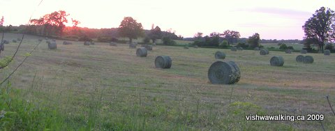
one point, with towers stretching across the fields.Round bales in a very trim field east of Hoard's Station.
The trail angles to the north side of Hoards Road (County Road 80), then crosses Hoard's Creek on a separate wooden bridge with a surface that needs a little work. At Hoard's road, we move into Northumberland County, into the municipality of Trent Hills, a conglomerate of urban and rural communities that includes Hoard's Station.
Beyond the bridge are fields on the right (north) residences on the left, followed by small grain silos that are part of Hoards Station. At Hoard's Church Road, there is a garage on the left and a United Church with a little cemetery just off the trail. (Take care: on some maps — including Google — this road is misnamed "Hoards Road."
 Farms on this stretch look more prosperous
than their cousins farther east.
Farms on this stretch look more prosperous
than their cousins farther east.In May and June, with the fields a rich green, and cattle lazing on hillsides,it made for almost cliché pastoral scenes.
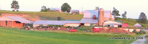
A classic rural scene. Barns, cows, an early evening in June. Very peaceful.
Somehow, Brueghel's painting of Icarus comes to mind: everything so still and beautiful and normal. We did not see Icarus falling from the sky; our world is still intact.
Rating:
Easy.
Walked May 2, 23,
June 24, 2009
7) Hoards Church Road (Hoard's Station) to Burnbrae Road (6th Line East), just east of Campbellford
Total: 9.4
kilometres
Running total: 47.8 kilometres
Running total: 47.8 kilometres
Pick
a fine summer, early evening and this next section can be magic. It's
pretty well all field and farms, with a strip of bushes and trees along
the rail bed. A little bit of forest comes in briefly as you near the
4th Line and there are brief sections where the bed rides low and you
can't see the fields above.
Have a look at the bell at Hoards United Church at the beginning of this section. It was cast locally by one "Mr. Bunce," according to the inscription under the bell.
Have a look at the bell at Hoards United Church at the beginning of this section. It was cast locally by one "Mr. Bunce," according to the inscription under the bell.
 After
that, it's one pastoral scene after another: round bales in the field,
cows chewing their cud (very loudly, by the way, no table manners at
all, but very friendly), sheep bleating loudly while their protective
dog shepherd barks ferociously, a llama sternly but silently watching
amidst the same flock, birds, farmers out haying, rolling hills of
grain — ah, I hear you claim, he's getting far too romantic
and
sentimental. I swear, this is all packed into one short walk between
Hoard's station and the 4th line.
After
that, it's one pastoral scene after another: round bales in the field,
cows chewing their cud (very loudly, by the way, no table manners at
all, but very friendly), sheep bleating loudly while their protective
dog shepherd barks ferociously, a llama sternly but silently watching
amidst the same flock, birds, farmers out haying, rolling hills of
grain — ah, I hear you claim, he's getting far too romantic
and
sentimental. I swear, this is all packed into one short walk between
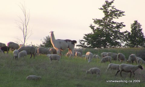
Hoard's station and the 4th line.This llama was silent but very attentive as I walked by. Long after I'd passed,
she was still staring at me. On the June day I walked this section near Pethericks
Road, there were lots of lambs frolicking about (what else do lambs do, anyway?).
 The
only thing to watch out for is poison ivy, which lines the edges of the
rail bed along this section and previous sections. If
you stick to the trail you'll have no trouble.
The
only thing to watch out for is poison ivy, which lines the edges of the
rail bed along this section and previous sections. If
you stick to the trail you'll have no trouble.There's a nice-looking barn on the left side as you come up to the 4th line; the road that splits off the trail at the 4th line leads to it. At one point the trail rides slightly high and you get to look down through the trees on any cows that might be in the adjacent fields.
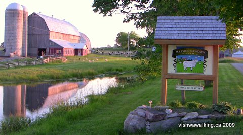
Masson Meadow Farm
on Pethericks Road, which this section of the trail passes
over 2.5 kilometres north-west of Hoards Station.
I had a good chat with the Jersey cows at the junction of the trail and the 4th line; they gathered at the fence as I came up to the road. A very sociable lot.
The trail now parallels the 4th line westward, with several dairy farms along the way. These truly are the rolling hills of Northumberland county. In mid-July after a wet spell, the fields are lush and green, spreading up and out from the trail. If you walk in early evening, you can catch a farmer or two dealing with her/his cattle.
 After the
4th Line, the trail crosses Devil's Valley Road (where there's a house
on your immediate left), then gently winds another 1.4 kilometres to the
5th line. There are blackberry and raspberry bushes along the way and
an apple tree just on the left after Devil's Valley Road. If you happen
to walk in berry season, take care to avoid the poison ivy when you're wading
into any bushes. There's a lot of it lining the trail in places.
After the
4th Line, the trail crosses Devil's Valley Road (where there's a house
on your immediate left), then gently winds another 1.4 kilometres to the
5th line. There are blackberry and raspberry bushes along the way and
an apple tree just on the left after Devil's Valley Road. If you happen
to walk in berry season, take care to avoid the poison ivy when you're wading
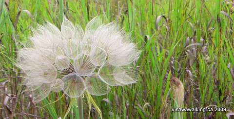
into any bushes. There's a lot of it lining the trail in places.This beautiful seed flower (I don't know what it's called) was just at the edge of
the trail south of Loucks Road — a ghostly, ephemeral grouping of seeds waiting for
a good breeze to disperse them.
the trail south of Loucks Road — a ghostly, ephemeral grouping of seeds waiting for
a good breeze to disperse them.
At
the 5th Line east, the trail curves to the left and parallels the road
for a while. As it curves northwestward away from the road, it
passes two houses on the left. The first is a strange trailer affair
with a falling-apart particle-board roof over it.
Immediately afterwards you will pass over a little stream, which was dried up when I walked this section in August. It was also difficult to see under the thick undergrowth.
South of Loucks Road, there's an apple tree on the right-hand side with tasty but very tart little apples on it in mid-August.
North of Loucks Road, the rail bed cuts into the hillside a bit and there are banks on either side. Unfortunately unscrupulous people have taken the opportunity to dump garbage here. Old tires, beer cases, clothes and the like have been left here. Some of this garbage has been here for quite a while. Presumably the banks have allowed the dumping to be done undetected.
 After
Loucks Road, it's a short jaunt to Burnbrae Road (6th Line east).
There's a map here outlining the area's trails and a box to one side
with "Maps" written on it. However, poison ivy surrounded the sign and
the box, so I did not venture to check it out.
After
Loucks Road, it's a short jaunt to Burnbrae Road (6th Line east).
There's a map here outlining the area's trails and a box to one side
with "Maps" written on it. However, poison ivy surrounded the sign and
the box, so I did not venture to check it out.At Burnbrae Road, the trail ends, although the rail bed continues.There are cement pylons on the north side of the road across the rail bed continuation. I will walk that soon and report on whether it is possible to walk it.
The rail bed part part of the trail ends here at Burnbrae Road (6th Line East) just
west of Campbellford. Notice the cement pylons on the north side. The rail bed continues,
but it is quite overgrown. The sign contains a map of trails of the area (mostly for snowmobiles
and ATVs). The sign and the blue map box attached to it are surrounded by poison ivy, so it was
not possible to check the map box out.
The
official Trans Canada Trail heads off westward along Burnbrae Road into
the south-east side of Campbellford. Below, I'll list some of the the
possible routes through Campbellford to reconnect with the rail trail
on the west side of town.
Rating: Easy.
Easy.Walked:
June 25, July 20, 21, August 9, 2009
Campbellford
8) Burnbrae Road to the intersection of Grand Road and Alma Street (Campbellford)
Total: 5.8 kilometres
Running Total: 53.6 kilometres
At Burnbrae Road, you have some alternatives:
1) Take the route as described in the Trans Canada Trails "Trail Locator" page. It suggests you turn left on Burnbrae, turn left on Centre Street (County Road 8) and walk into Ferris Provincial Park to Ranney Falls Suspension Bridge. This is the most boring alternative.
2) Walk left at Burnbrae as above, but at Centre Street cut south on a trail that starts at the south west corner of Burnbrae and Centre and runs through Ferris Park to the suspension bridge. Park literature lists this route as part of the Trans Canada Trail. This is far superior to walking south down the relatively high-traffic Centre Street. This is the route I have measured for this section which comes in at 4.5 kilometres; the third option described below is 4 kilometres long. I didn't walk Centre Street to Ferris Park and don't recommend it.
3) Continue on the trail bed on the north side of Burnbrae, then take Cockburn and Second streets to Saskatoon Street. Turn left here and walk along the banks of the Trent to Ranney Falls suspension bridge, where all three choices meet. This route has some problems, but they are not insurmountable and you spend less time on boring roads. The roads you do take are interesting and in town. It takes you close to downtown, so a quick detour for a meal or even a movie is possible. It also takes you past a beer store, a chocolate outlet and a (separate) chocolate factory. This is my preferred route.
If you are doing a loop here, you can combine some of these options.
Route #1:
The trail meets Burnbrae Road (the 6th Line East) just under 1 kilometre east of Centre Street. Head left thttp://turnstone.ca/index.phpoward Centre Street. The most interesting spots in this section are Burnbrae Gardens, a long-term care facility on the north side of the road and the little cemetery at little farther along on on the same side.
At Centre Street, turn south. I have not walked this road, but traffic can move at a fair clip along this section running south out of Campbellford. The entrance to Ferris Provincial Park is 1.4 kilometres from Burnbrae Road. Turn right here and walk back northward to the park gates. Shortly after this, the road meets the route described in Route #2. Head left here and follow the Route #2 description.
Route #2:
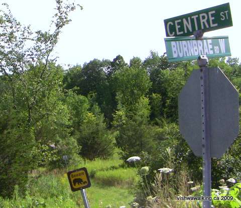 As
in Route #1, head east down Burnbrae Road. From the south-west corner
of Centre and Burnbrae, you'll see a trail heading off at an angle.
There's a bear and bear cub warning sign indicating the trail.
As
in Route #1, head east down Burnbrae Road. From the south-west corner
of Centre and Burnbrae, you'll see a trail heading off at an angle.
There's a bear and bear cub warning sign indicating the trail.
This trail winds south along the bottom edge of a ridge (on your right). County Road #8 is not far to your left. The path is mown grass and is clear and easy on your feet.
After passing a sign banning ATVs in the park, you'll turn left and face a house in front of you. However, the trail turns right and continues past the Ferris Provincial park offices. Shortly afterwards, the road branches again.
Stay right; the left road heads off to the front gate. Follow the road around as it winds toward Ranney Fall Suspension Bridge. You'll see intriguing trails heading off to the left and right as well as a road heading southward. These trails with colours for names need investigating; I haven't walked them, but they're definitely on my list.
Stay with the road until it come to a "T" intersection; this is the extension of Saskatoon Avenue (but you can't drive north from here to the town). There are signs here pointing the way to the bridge. Turn left and follow the road until you come to a trail. There is a parking lot here and a field beyond it with a picnic table off to the right; it's a good place to have a picnic.
The trail to the bridge is clear, running off to the right. Follow it to the bridge.
Before you cross the bridge, it's worth taking a brief diversion north along the trail that runs along the river's edge. You'll get some good views of Ranney Falls to the north, the hydro outlet on the opposite bank and the gorge itself. Not far north is a little observation spot by the falls, where you can look at the falls safely behind a railing.
From the bridge, follow the trail as described below in Route #3.
Route #3
From Burnbrae Road, continue north on the rail bed. There are four cement pylons in front of a dilapidated wire fence on the north side of the road. You can easily find a spot to step over the fence. However, watch the poison ivy. It's all over here, sometimes hidden in the underbrush. The terrain is a bit rough, but stick as much as possible to the high ground and it sorts itself out.
For a brief section, the trail is overgrown and the poison ivy continues to be a bit of a problem. Eventually the trail meets a farmer's double track coming from the back of a house on Burnbrae Road. The trail is easy here, until you meet more pylons just before crossing Dart Road.
You'll see the Dart foam recycling factory to your right. Dart is a U.S. company with manufacturing operations around the world. They make plastic containers for food and other products. Most people would call the material "Styrofoam" but Dart doesn't because that is a trademark of the Dow Chemical Company. The generic name is polystyrene. It's been in Campbellford since 1985.
Follow the Dart fence eastward across a dried (in August) creek bed. If you walk close to the corn field, there's a stretch of earth along the last line of corn where the undergrowth is considerably less; I imagine the chemicals used to kill the weeds in the corn field are responsible for this little strip. If you're walking this section in the height of summer, this route could avoid the worst of the undergrowth.
As the Dart fence ends, you'll see a little hill. Climb it to get a view of Campbellford to the north-west. Then, skirt the hill and head along the left side of the line of trees until you get to the wooden fences on your left enclosing suburban gardens. The trees are a relief if you're walking on a hot day.
Shortly after you pass along the fences, you'll have to jog right to the edge of a bean field, as the path straight ahead leads to someone's back yard. Skirt the bean field and walk along the edge of the lawns and the field until you come to an open spot. I'm not sure if this is actually a little park, but the space between houses is enough to pass unobtrusively. Just before you reach the street, you'll pass a little apple tree.
You are now on Elmore Street. Jog right to get to Cockburn Street and walk westward to Centre Street, where you'll find a beer store. It's nicely placed if you are in the middle of a hot walk. They have only one brand of beer you can buy in single bottles: a polish beer called Zywiec.
If you buy a bottle, don't open it immediately, because you'll soon be passing The World's Finest Chocolate outlet, where all kinds of candy is sold. Continue down Cockburn which turns into 2nd Street. The World's Finest Chocolate. is on the south side of the street. The Chicago-based company has had its Canadian operations in Campbellford since 1958.
Traditionally, the company (at least in Canada) has focused on providing chocolates for schools and charities to use as fundraisers. However, schools recently have focused more on flogging healthy stuff and shied away from chocolates, which has hurt the company.
Now here's the weird part: Immediately to the west of the World's Finest is Blommer Chocolate, with a plant in Campbellford since 2006.. According to this company they actually make the finest chocolate in the world. They are also based in Chicago. They also say they are "North America's largest processor of cocoa beans and ingredient chocolate" The Campbellford plant ships most of its product south of the border.
Meanwhile, World's Finest ships its product in from Chicago. And they say capitalists thrive on efficiency. I'm not convinced...
Nevertheless, I bought the Chicago chocolate. A really nice saleswoman gave me a frozen bottle of water to put in my pack so my chocolate almonds (two for the price of one!) wouldn't melt. The World's Finest have a single open room with all their products. In a second room, women stand by tables packaging the product as it streams in from Chicago.
Back to the street: continue down Second Street to Saskatoon Avenue. Have a few chocolates on the way. If it's a sunny day, glory in the day and ignore the fact that the World's Finest is not, in fact, the world's finest by a long stretch. Crack your bottle of Zywiec and note that these Polish folks make an OK beer, nice and light for a hot day, but again, far from remarkable. Maybe I should have stuck with my Sir Perry's Pear Cider in my backpack, which is the world's finest. Never fear! It's upward and onward to Saskatoon Avenue.
Head left down Saskatoon. The road passes the Trent River control dam. Notice the soccer pitches on your left.
By the way, to back up a bit, you can try to track part of the old rail bed by heading south down Centre Street at the beer store. Go right at 1st Street and then cut back north on King until the street runs out. Turn left before the fence.
Follow the fence left until you can squeeze out onto the road and follow the road west past the back of the chocolate factory and up a little hill into the parking lot of a small set of apartments. Then cut straight through a bit of brush onto the soccer pitches and finally on to Saskatoon Road.
 The
rail bed is not at all clear. You can imagine bits here and there, but
you have to skirt sections where there are now buildings and fences, so
it's not the most instructive of walks.
The
rail bed is not at all clear. You can imagine bits here and there, but
you have to skirt sections where there are now buildings and fences, so
it's not the most instructive of walks.
However you get here, at the dam you must make a short diversion to climb the hill to the shore of the river. The Canadian Tire on the opposite bank mars the view a bit.
However, if you squint a lot or sit with one of the old railway abutments blocking the unsightly stuff, you can create a good view. It's a good peaceful spot to pause.
Continue down Saskatoon. The river below the dam does change. A sign warns you to stay off the river bed. It's wise counsel. I've seen the river bed almost dry; I've also seen it gushing with white water after they've opened the dams.
To your left is a youth centre and a skate park. The latter was in the middle stages of construction when I passed by in August, 2009. A sign indicated that fundraisers were still quite a way from their goal for several recreational projects.
On down Saskatoon, you'll notice some grand houses on your left before the road ends at a gate that announces that Ferris Park is very near
Past the gate, the trail turns into a pleasant path that winds to the old front gate of Ferris Park. Saskatoon Avenue, (which is not drivable at this point), heads up a slight incline. However, the riverside path is more interesting. It winds about until it reaches a little platform near the water where you can view Ranney Falls. From the platform, climb the hill to an open grassy spot where you can rest at a bench and get another view of the falls. Then the trail winds a bit farther to the bridge.
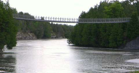 The
bridge is fun. It sways slightly, especially if there are a few people
on it. As you get to the centre, you get great views of the falls and
the sides of the gorge both to the north and to the south. The north
part of the river has a few rapids that whitewater canoe enthusiasts
can ponder over, while the south view is more ponderous as the river
winds down to reconnect with the Trent Canal that runs just to the west.
The
bridge is fun. It sways slightly, especially if there are a few people
on it. As you get to the centre, you get great views of the falls and
the sides of the gorge both to the north and to the south. The north
part of the river has a few rapids that whitewater canoe enthusiasts
can ponder over, while the south view is more ponderous as the river
winds down to reconnect with the Trent Canal that runs just to the west.
The Ranney Fall suspension bridge.
The canal and the hydro dam draw the water they need from the river. The hydro dam spits the water back through a gorge cut into the rock near the hydro plant..
From the bridge, the trail runs by the hydro generating plant to the right. If you cut right, you can walk down a road into a little gully and see the water as it rushes out from beneath the main building. Then at the front of the building, notice the "forebay" area — a constructed pond in front of the main building.
After that it's over the bridge, with a look to the left to see the Trent-Severn Waterway Locks Number 11 and 12. Then turn right along Trent Road. Jog slightly right to get on the Rotary Trail which follows the canal around until you get to the Rotary's gazebo that sits between Grand Road (the main southbound road out of Campbellford) and the canal-side Rotary Trail. There's a sign here that gives you a quick history of Campbellford.
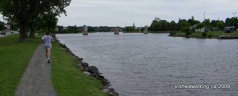
 It's
1.3 kilometres from the gazebo to Alma Street, along the Rotary
Trail which takes you along the west side of the canal. On a nice
day, this can be a pleasant walk along a path of fine gravel, although
traffic noise is always present.
It's
1.3 kilometres from the gazebo to Alma Street, along the Rotary
Trail which takes you along the west side of the canal. On a nice
day, this can be a pleasant walk along a path of fine gravel, although
traffic noise is always present.
The Trent-Severn Canal, Campbellford, looking south from the west bank.
On your left, the Houses of Grand Street turn from relatively modern suburban to some grand old 19th-century brick homes. Across the canal, Trent Drive is lined with standard suburban homes.
 The Trent-Severn Canal (see Wikipedia for a general description)
is 386 kilometres long, operated by Parks Canada, and used for
recreational boating. Since the canal requires a relatively consistent
water level, it draws from lakes and human-made reservoirs to maintain
it.
The Trent-Severn Canal (see Wikipedia for a general description)
is 386 kilometres long, operated by Parks Canada, and used for
recreational boating. Since the canal requires a relatively consistent
water level, it draws from lakes and human-made reservoirs to maintain
it.
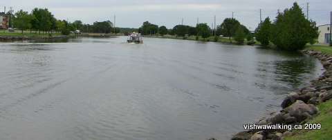
A look northward from the west side of the Trent-Severn Canal in Campbellford. This
shot gives a good idea of the Rotary Trail. It runs between the canal and Grand Road
(seen just to the left in the photo) on a small strip of greenery. The abutments in the canal
are from the old bridge that used to carry the Grand Junction Railway. The Trans Canada will
pick up the rail bed again just west of Alma Road.
There is competition for water use cottagers, canal users and the plants and animals living on or near the waterways. The loss of forests and marshes because of urban and agricultural development has made water retention is an ongoing problem. The priority of the canal's needs has caused problems for cottagers and wildlife on reservoir lakes many miles from the canal itself.
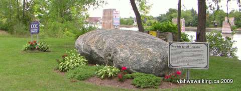 Have a look at the "erratic" or Gabbro boulder installed along the trail. (This link gives a detailed history of the rock. See the rest of the site — Turnstone.ca — if you're interested in things geological, both local and otherwise.)
Rating: Burnbrae and Centre roads:; Rail sections, and Ferris Park (road sections): ; Campbellford streets, riverside trail sections and Ranney bridge sections: .
How to get there: Campbellford is just under 28 kilometres north of the Highway #401 at the County Road #30 cutoff. (Brighton is signposted as being south, but you'll be heading north.) County Road #30 is 134 kilometres east from the Don Valley and Highway #401 in Toronto and 15 kilometres west of the Highway #401 Trenton cutoff
As you come into the town, watch out for the Rotary gazebo on the right, and the Rotary trail along the Trent Canal, which will pinpoint the trail. If you want to get to Ferris Provincial Park, continue north up #30 (which is now Grand Road) up to the lights and the bridge, turn right over the bridge and head through town. Drive up the hill to Centre Street and turn right. Drive just over two kilometres to the gates of the park.
To get to Saskatoon Avenue along the Trent River near the back of Ferris Park, turn right at Front Street immediately on the east side of the Campbellford bridge. Stay right as the streets head south until you flow into Saskatoon Avenue. There's a small parking spot at the gate just before the road turns into a trail.
4) On to the next section: Campbellford to Hastings
2) Back to the Madoc Junction to Anson section
Total: 5.8 kilometres
Running Total: 53.6 kilometres
At Burnbrae Road, you have some alternatives:
1) Take the route as described in the Trans Canada Trails "Trail Locator" page. It suggests you turn left on Burnbrae, turn left on Centre Street (County Road 8) and walk into Ferris Provincial Park to Ranney Falls Suspension Bridge. This is the most boring alternative.
2) Walk left at Burnbrae as above, but at Centre Street cut south on a trail that starts at the south west corner of Burnbrae and Centre and runs through Ferris Park to the suspension bridge. Park literature lists this route as part of the Trans Canada Trail. This is far superior to walking south down the relatively high-traffic Centre Street. This is the route I have measured for this section which comes in at 4.5 kilometres; the third option described below is 4 kilometres long. I didn't walk Centre Street to Ferris Park and don't recommend it.
3) Continue on the trail bed on the north side of Burnbrae, then take Cockburn and Second streets to Saskatoon Street. Turn left here and walk along the banks of the Trent to Ranney Falls suspension bridge, where all three choices meet. This route has some problems, but they are not insurmountable and you spend less time on boring roads. The roads you do take are interesting and in town. It takes you close to downtown, so a quick detour for a meal or even a movie is possible. It also takes you past a beer store, a chocolate outlet and a (separate) chocolate factory. This is my preferred route.
If you are doing a loop here, you can combine some of these options.
Route #1:
The trail meets Burnbrae Road (the 6th Line East) just under 1 kilometre east of Centre Street. Head left thttp://turnstone.ca/index.phpoward Centre Street. The most interesting spots in this section are Burnbrae Gardens, a long-term care facility on the north side of the road and the little cemetery at little farther along on on the same side.
At Centre Street, turn south. I have not walked this road, but traffic can move at a fair clip along this section running south out of Campbellford. The entrance to Ferris Provincial Park is 1.4 kilometres from Burnbrae Road. Turn right here and walk back northward to the park gates. Shortly after this, the road meets the route described in Route #2. Head left here and follow the Route #2 description.
Route #2:
As
in Route #1, head east down Burnbrae Road. From the south-west corner
of Centre and Burnbrae, you'll see a trail heading off at an angle.
There's a bear and bear cub warning sign indicating the trail.This trail winds south along the bottom edge of a ridge (on your right). County Road #8 is not far to your left. The path is mown grass and is clear and easy on your feet.
After passing a sign banning ATVs in the park, you'll turn left and face a house in front of you. However, the trail turns right and continues past the Ferris Provincial park offices. Shortly afterwards, the road branches again.
Stay right; the left road heads off to the front gate. Follow the road around as it winds toward Ranney Fall Suspension Bridge. You'll see intriguing trails heading off to the left and right as well as a road heading southward. These trails with colours for names need investigating; I haven't walked them, but they're definitely on my list.
Stay with the road until it come to a "T" intersection; this is the extension of Saskatoon Avenue (but you can't drive north from here to the town). There are signs here pointing the way to the bridge. Turn left and follow the road until you come to a trail. There is a parking lot here and a field beyond it with a picnic table off to the right; it's a good place to have a picnic.
The trail to the bridge is clear, running off to the right. Follow it to the bridge.
Before you cross the bridge, it's worth taking a brief diversion north along the trail that runs along the river's edge. You'll get some good views of Ranney Falls to the north, the hydro outlet on the opposite bank and the gorge itself. Not far north is a little observation spot by the falls, where you can look at the falls safely behind a railing.
From the bridge, follow the trail as described below in Route #3.
Route #3
From Burnbrae Road, continue north on the rail bed. There are four cement pylons in front of a dilapidated wire fence on the north side of the road. You can easily find a spot to step over the fence. However, watch the poison ivy. It's all over here, sometimes hidden in the underbrush. The terrain is a bit rough, but stick as much as possible to the high ground and it sorts itself out.
For a brief section, the trail is overgrown and the poison ivy continues to be a bit of a problem. Eventually the trail meets a farmer's double track coming from the back of a house on Burnbrae Road. The trail is easy here, until you meet more pylons just before crossing Dart Road.
You'll see the Dart foam recycling factory to your right. Dart is a U.S. company with manufacturing operations around the world. They make plastic containers for food and other products. Most people would call the material "Styrofoam" but Dart doesn't because that is a trademark of the Dow Chemical Company. The generic name is polystyrene. It's been in Campbellford since 1985.
Follow the Dart fence eastward across a dried (in August) creek bed. If you walk close to the corn field, there's a stretch of earth along the last line of corn where the undergrowth is considerably less; I imagine the chemicals used to kill the weeds in the corn field are responsible for this little strip. If you're walking this section in the height of summer, this route could avoid the worst of the undergrowth.
As the Dart fence ends, you'll see a little hill. Climb it to get a view of Campbellford to the north-west. Then, skirt the hill and head along the left side of the line of trees until you get to the wooden fences on your left enclosing suburban gardens. The trees are a relief if you're walking on a hot day.
Shortly after you pass along the fences, you'll have to jog right to the edge of a bean field, as the path straight ahead leads to someone's back yard. Skirt the bean field and walk along the edge of the lawns and the field until you come to an open spot. I'm not sure if this is actually a little park, but the space between houses is enough to pass unobtrusively. Just before you reach the street, you'll pass a little apple tree.
You are now on Elmore Street. Jog right to get to Cockburn Street and walk westward to Centre Street, where you'll find a beer store. It's nicely placed if you are in the middle of a hot walk. They have only one brand of beer you can buy in single bottles: a polish beer called Zywiec.
If you buy a bottle, don't open it immediately, because you'll soon be passing The World's Finest Chocolate outlet, where all kinds of candy is sold. Continue down Cockburn which turns into 2nd Street. The World's Finest Chocolate. is on the south side of the street. The Chicago-based company has had its Canadian operations in Campbellford since 1958.
Traditionally, the company (at least in Canada) has focused on providing chocolates for schools and charities to use as fundraisers. However, schools recently have focused more on flogging healthy stuff and shied away from chocolates, which has hurt the company.
Now here's the weird part: Immediately to the west of the World's Finest is Blommer Chocolate, with a plant in Campbellford since 2006.. According to this company they actually make the finest chocolate in the world. They are also based in Chicago. They also say they are "North America's largest processor of cocoa beans and ingredient chocolate" The Campbellford plant ships most of its product south of the border.
Meanwhile, World's Finest ships its product in from Chicago. And they say capitalists thrive on efficiency. I'm not convinced...
Nevertheless, I bought the Chicago chocolate. A really nice saleswoman gave me a frozen bottle of water to put in my pack so my chocolate almonds (two for the price of one!) wouldn't melt. The World's Finest have a single open room with all their products. In a second room, women stand by tables packaging the product as it streams in from Chicago.
Back to the street: continue down Second Street to Saskatoon Avenue. Have a few chocolates on the way. If it's a sunny day, glory in the day and ignore the fact that the World's Finest is not, in fact, the world's finest by a long stretch. Crack your bottle of Zywiec and note that these Polish folks make an OK beer, nice and light for a hot day, but again, far from remarkable. Maybe I should have stuck with my Sir Perry's Pear Cider in my backpack, which is the world's finest. Never fear! It's upward and onward to Saskatoon Avenue.
Head left down Saskatoon. The road passes the Trent River control dam. Notice the soccer pitches on your left.
By the way, to back up a bit, you can try to track part of the old rail bed by heading south down Centre Street at the beer store. Go right at 1st Street and then cut back north on King until the street runs out. Turn left before the fence.
Follow the fence left until you can squeeze out onto the road and follow the road west past the back of the chocolate factory and up a little hill into the parking lot of a small set of apartments. Then cut straight through a bit of brush onto the soccer pitches and finally on to Saskatoon Road.
The
rail bed is not at all clear. You can imagine bits here and there, but
you have to skirt sections where there are now buildings and fences, so
it's not the most instructive of walks.However you get here, at the dam you must make a short diversion to climb the hill to the shore of the river. The Canadian Tire on the opposite bank mars the view a bit.
You can just make out the
abutments to the old railway bridge here just to the west
of Saskatoon Avenue in Campbellford, near the soccer pitches. The rail bed is pretty well
lost as it passes through the town; this is a last reminder. On a warm summer evening, this
is a fine place to pass the time. (Photo July 20, 2009)
of Saskatoon Avenue in Campbellford, near the soccer pitches. The rail bed is pretty well
lost as it passes through the town; this is a last reminder. On a warm summer evening, this
is a fine place to pass the time. (Photo July 20, 2009)
However, if you squint a lot or sit with one of the old railway abutments blocking the unsightly stuff, you can create a good view. It's a good peaceful spot to pause.
Continue down Saskatoon. The river below the dam does change. A sign warns you to stay off the river bed. It's wise counsel. I've seen the river bed almost dry; I've also seen it gushing with white water after they've opened the dams.
To your left is a youth centre and a skate park. The latter was in the middle stages of construction when I passed by in August, 2009. A sign indicated that fundraisers were still quite a way from their goal for several recreational projects.
On down Saskatoon, you'll notice some grand houses on your left before the road ends at a gate that announces that Ferris Park is very near
Past the gate, the trail turns into a pleasant path that winds to the old front gate of Ferris Park. Saskatoon Avenue, (which is not drivable at this point), heads up a slight incline. However, the riverside path is more interesting. It winds about until it reaches a little platform near the water where you can view Ranney Falls. From the platform, climb the hill to an open grassy spot where you can rest at a bench and get another view of the falls. Then the trail winds a bit farther to the bridge.
The
bridge is fun. It sways slightly, especially if there are a few people
on it. As you get to the centre, you get great views of the falls and
the sides of the gorge both to the north and to the south. The north
part of the river has a few rapids that whitewater canoe enthusiasts
can ponder over, while the south view is more ponderous as the river
winds down to reconnect with the Trent Canal that runs just to the west.The Ranney Fall suspension bridge.
The canal and the hydro dam draw the water they need from the river. The hydro dam spits the water back through a gorge cut into the rock near the hydro plant..
From the bridge, the trail runs by the hydro generating plant to the right. If you cut right, you can walk down a road into a little gully and see the water as it rushes out from beneath the main building. Then at the front of the building, notice the "forebay" area — a constructed pond in front of the main building.
After that it's over the bridge, with a look to the left to see the Trent-Severn Waterway Locks Number 11 and 12. Then turn right along Trent Road. Jog slightly right to get on the Rotary Trail which follows the canal around until you get to the Rotary's gazebo that sits between Grand Road (the main southbound road out of Campbellford) and the canal-side Rotary Trail. There's a sign here that gives you a quick history of Campbellford.
It's
1.3 kilometres from the gazebo to Alma Street, along the Rotary
Trail which takes you along the west side of the canal. On a nice
day, this can be a pleasant walk along a path of fine gravel, although
traffic noise is always present.The Trent-Severn Canal, Campbellford, looking south from the west bank.
On your left, the Houses of Grand Street turn from relatively modern suburban to some grand old 19th-century brick homes. Across the canal, Trent Drive is lined with standard suburban homes.
The Trent-Severn Canal (see Wikipedia for a general description)
is 386 kilometres long, operated by Parks Canada, and used for
recreational boating. Since the canal requires a relatively consistent
water level, it draws from lakes and human-made reservoirs to maintain
it. A look northward from the west side of the Trent-Severn Canal in Campbellford. This
shot gives a good idea of the Rotary Trail. It runs between the canal and Grand Road
(seen just to the left in the photo) on a small strip of greenery. The abutments in the canal
are from the old bridge that used to carry the Grand Junction Railway. The Trans Canada will
pick up the rail bed again just west of Alma Road.
There is competition for water use cottagers, canal users and the plants and animals living on or near the waterways. The loss of forests and marshes because of urban and agricultural development has made water retention is an ongoing problem. The priority of the canal's needs has caused problems for cottagers and wildlife on reservoir lakes many miles from the canal itself.
Have a look at the "erratic" or Gabbro boulder installed along the trail. (This link gives a detailed history of the rock. See the rest of the site — Turnstone.ca — if you're interested in things geological, both local and otherwise.)An "erratic boulder" can be found beside the Rotary Trail in Campbellford. Notice the
old railway abutments in the canal in the background.
At Alma Street, turn left. The
Canadian Tire will be on your left on the west side of Grand Road. It
sits on the land the Grand Junction Railway once ran. We'll rejoin the
Grand Junction rail bed shortly.old railway abutments in the canal in the background.
Rating: Burnbrae and Centre roads:
; Rail sections, and Ferris Park (road sections): ; Campbellford streets, riverside trail sections and Ranney bridge sections: .Walked: August 11, 28, 2009
How to get there: Campbellford is just under 28 kilometres north of the Highway #401 at the County Road #30 cutoff. (Brighton is signposted as being south, but you'll be heading north.) County Road #30 is 134 kilometres east from the Don Valley and Highway #401 in Toronto and 15 kilometres west of the Highway #401 Trenton cutoff
As you come into the town, watch out for the Rotary gazebo on the right, and the Rotary trail along the Trent Canal, which will pinpoint the trail. If you want to get to Ferris Provincial Park, continue north up #30 (which is now Grand Road) up to the lights and the bridge, turn right over the bridge and head through town. Drive up the hill to Centre Street and turn right. Drive just over two kilometres to the gates of the park.
To get to Saskatoon Avenue along the Trent River near the back of Ferris Park, turn right at Front Street immediately on the east side of the Campbellford bridge. Stay right as the streets head south until you flow into Saskatoon Avenue. There's a small parking spot at the gate just before the road turns into a trail.
2) Back to the Madoc Junction to Anson section
Home | Contact Us | Site Map
Page
created: June 16, 2009
Updated: September 25, 2009
Updated: September 25, 2009