About Us
Vishwawalking explained
 Ratings Explained
Vishwawalks
Day walks
Food
Funky Places
Future walks
Gear
Get Lost
Good reads
Hap also has a late sticker on the plate of the piano indicating he tuned it up to 1990 (see below)
Links
Right to Ramble
Site map
Contact us
Vishwawalking
September,
2011
Warning: I had an email from an explorer who went the official route and contacted authorities before going onto this property. He told me authorities have more cameras and there are those with binoculars keeping an eye on the site. Police will be called and those caught, he said, would be prosecuted. My necessary and categorical statement: don't try to trespass. Whatever you do on your own, take care, adventurers!
Warning: I had an email from an explorer who went the official route and contacted authorities before going onto this property. He told me authorities have more cameras and there are those with binoculars keeping an eye on the site. Police will be called and those caught, he said, would be prosecuted. My necessary and categorical statement: don't try to trespass. Whatever you do on your own, take care, adventurers!
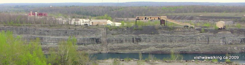
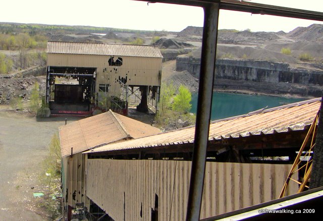
An
overview
of Marmoraton (the Marmora Mine) taken from the
heights
of the quarry to the west. The red building on the left is the
still-operating Dynatec talc mill (Canada Talc or Cantal). The
white
stuff is piles of unrefined talc. The two orangy edifices are
the
abandoned Marmoraton buildings, now full of holes. The big
cliffs and a
bit of the lake in the the old open pit are in the foreground.
Marmora Mines
For more photos click here or on any photoThe
history
In 1948 an aeromagnetic survey revealed a magnetite ore body just east of Marmora, Ontario. (An aeromnagnetic survey involves an airplane towing a magnetometer, which is basically a big magnet that can record variations in the magnetic field. Magnetite is a ferrimagnetic material, roughly meaning it has magnetic qualities. It is the most naturally magnetic of all minerals. It is also a source of iron ore.)
A mine was developed here, called Marmoraton. (Marmora is derived from the Latin word for "marble"; thus "marmoreal" and "marmormoreus," meaning "like marble.")
But we digress... In 1953, the owners of Marmoraton, Bethlehem Steel Mills of New York (come now, you didn't think such a major operation could be Canadian did you?), began stripping 120 feet of the limestone "overburden," to get at the magnetite. In 1955, shipments began of iron ore pellets from the mine. In total, 1.3 million tons of iron ore left the mine. Another 3.5 million tons of waste rocks littered the landscape.
An average of 520,00 tons of ore left the mine daily between 1955 and 1978, when the mine closed. Ore was shipped by train to Picton, Ontario, located on Lake Ontario to the south, where it was loaded on boats.
At its height, the mine employed 300 people. As with many mine operations the love 'em and leave 'em operation lifted Marmora up, only to drop it unceremoniously when it was not needed. Needless to say, along with the iron ore, most of the profits were exported. On — or rather, "with" — this rock New York was built.
 The
site itself is 853 metres (2800 feet) long, 457metres (1500 feet)
wide
and 168 metres (550 feet deep. Two huge pumps ran constantly
to
keep water from the mine. Today, the pumps are turned off and you
can
drive to the end of Marmora Mine Road and see the big green-blue
lake
that has formed in the old pit.
The
site itself is 853 metres (2800 feet) long, 457metres (1500 feet)
wide
and 168 metres (550 feet deep. Two huge pumps ran constantly
to
keep water from the mine. Today, the pumps are turned off and you
can
drive to the end of Marmora Mine Road and see the big green-blue
lake
that has formed in the old pit.
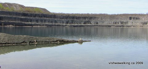
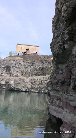
The view from the lake. The cliffs are impressive. The water has a greenish-blue hue.
Elsewhere, I describe Greensides Farm, where visions of the Virgin Mary have been seen. It's just east of the Marmora Mine. There's a theory that the huge water load pressure of the mine creates a strain that results in "odd luminous events." According to Dr. Michael Persinger, the area will reached "maximum hydrological water load" in around 2009. Take care as you walk through the mine site and keep an eye out for visions. (Update: Persinger mades these clims in a video entitled Maximum Marmora Phenomenon," a YouTube piece that has since been pulled from the Internet. I walked this in 2009; I'm not sure what the post-2009 effect should be concerning luminous events. Noted February 10, 2015)
The site
To the left (east) of the open pit is an operating mill that processes talc from an nearby Madoc mine. A fence separates the open pit from the operating mine.
 The public viewing cage above the open
pit gives you an impressive overview of the old Marmoraton
operation.
The public viewing cage above the open
pit gives you an impressive overview of the old Marmoraton
operation.
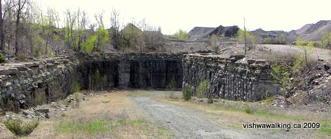
The fence has several gaps that will allow you into the mine itself. I first investigated the lake. If you walk past the abandoned buildings, there is a road that cuts down through the rock and curves around to the lake.
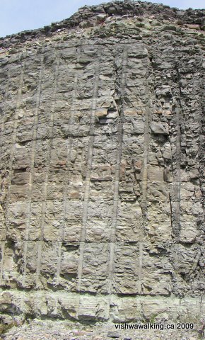
Notice as you walk down areas where the water drips from the sides of the cliffs. As you turn the corner toward the lake, there are some very clear cuts, showing how the rock was blasted. Further on, the road cruises gracefully to the lake.
 The
lake
has a kind of greenish-blue hue (emerald?), but that's not as
evident close up. Looking from the lake's surface up an the huge
rock
cliffs is impressive. This is all human-created, but there's a
strange
beauty to all this destruction.
The
lake
has a kind of greenish-blue hue (emerald?), but that's not as
evident close up. Looking from the lake's surface up an the huge
rock
cliffs is impressive. This is all human-created, but there's a
strange
beauty to all this destruction.
Back up to the old buildings, there's lots to investigate here. it would need an experienced guide to explain the function of all the bits of machinery scattered about.
The long building is a bit challenging. There is a long conveyor stretching up to the top. You can clamber over a couple of welded bits of iron and then use the steps to get to the top, where you get a grand view of the lake and the viewing cage.
Back at ground level, the conveyor continues down into the ground. be prepared to get a little dirty here as access requires a little crawling to get under some metal barriers. Once in, steps lead downward to a damp little room that sits under the second building.
The little underground room does lead around to a set of steps that lead up. Don't be tempted: the steps are firmly barred at the top.
It's worth checking out the second building again to orient yourself and realize how the bits are put together. After that, have a look at the abandoned machinery lying around the building.
On the road to the lake: seven-inch holes were drilled
60 feet down and filled with 32,000 pounds of explosives.
Every blast yielded 20 to 80,000 tons of rock and ore.
This is the view from the top of the building with the conveyor, looking back toward the second building. The road to the lake is behind to the left. Notice the lake and the (operating) Aecon quarry in the background.
Below: the cliff side from the water's edge, with the abandoned building in the background.
 External sites to check out:
Rural routes has a good overview with pictures and a history. A YouTube will give you a decent overview. You may see off to your right a clip called "Marmora Mine 80 ft, " in which a young guy takes a leap off the cliff into the water below. Definitely not recommended.
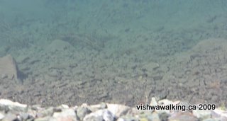
The greenish water has a beauty. I'm not sure what makes it this colour. I'd hate to guess what lies beneath these waters.
For more photos click here or on any photo
Back to the main Get Lost page
In 1948 an aeromagnetic survey revealed a magnetite ore body just east of Marmora, Ontario. (An aeromnagnetic survey involves an airplane towing a magnetometer, which is basically a big magnet that can record variations in the magnetic field. Magnetite is a ferrimagnetic material, roughly meaning it has magnetic qualities. It is the most naturally magnetic of all minerals. It is also a source of iron ore.)
A mine was developed here, called Marmoraton. (Marmora is derived from the Latin word for "marble"; thus "marmoreal" and "marmormoreus," meaning "like marble.")
But we digress... In 1953, the owners of Marmoraton, Bethlehem Steel Mills of New York (come now, you didn't think such a major operation could be Canadian did you?), began stripping 120 feet of the limestone "overburden," to get at the magnetite. In 1955, shipments began of iron ore pellets from the mine. In total, 1.3 million tons of iron ore left the mine. Another 3.5 million tons of waste rocks littered the landscape.
An average of 520,00 tons of ore left the mine daily between 1955 and 1978, when the mine closed. Ore was shipped by train to Picton, Ontario, located on Lake Ontario to the south, where it was loaded on boats.
At its height, the mine employed 300 people. As with many mine operations the love 'em and leave 'em operation lifted Marmora up, only to drop it unceremoniously when it was not needed. Needless to say, along with the iron ore, most of the profits were exported. On — or rather, "with" — this rock New York was built.
The
site itself is 853 metres (2800 feet) long, 457metres (1500 feet)
wide
and 168 metres (550 feet deep. Two huge pumps ran constantly
to
keep water from the mine. Today, the pumps are turned off and you
can
drive to the end of Marmora Mine Road and see the big green-blue
lake
that has formed in the old pit.The view from the lake. The cliffs are impressive. The water has a greenish-blue hue.
Elsewhere, I describe Greensides Farm, where visions of the Virgin Mary have been seen. It's just east of the Marmora Mine. There's a theory that the huge water load pressure of the mine creates a strain that results in "odd luminous events." According to Dr. Michael Persinger, the area will reached "maximum hydrological water load" in around 2009. Take care as you walk through the mine site and keep an eye out for visions. (Update: Persinger mades these clims in a video entitled Maximum Marmora Phenomenon," a YouTube piece that has since been pulled from the Internet. I walked this in 2009; I'm not sure what the post-2009 effect should be concerning luminous events. Noted February 10, 2015)
The site
To the left (east) of the open pit is an operating mill that processes talc from an nearby Madoc mine. A fence separates the open pit from the operating mine.
The public viewing cage above the open
pit gives you an impressive overview of the old Marmoraton
operation.The fence has several gaps that will allow you into the mine itself. I first investigated the lake. If you walk past the abandoned buildings, there is a road that cuts down through the rock and curves around to the lake.
Notice as you walk down areas where the water drips from the sides of the cliffs. As you turn the corner toward the lake, there are some very clear cuts, showing how the rock was blasted. Further on, the road cruises gracefully to the lake.
The
lake
has a kind of greenish-blue hue (emerald?), but that's not as
evident close up. Looking from the lake's surface up an the huge
rock
cliffs is impressive. This is all human-created, but there's a
strange
beauty to all this destruction.Back up to the old buildings, there's lots to investigate here. it would need an experienced guide to explain the function of all the bits of machinery scattered about.
The long building is a bit challenging. There is a long conveyor stretching up to the top. You can clamber over a couple of welded bits of iron and then use the steps to get to the top, where you get a grand view of the lake and the viewing cage.
Back at ground level, the conveyor continues down into the ground. be prepared to get a little dirty here as access requires a little crawling to get under some metal barriers. Once in, steps lead downward to a damp little room that sits under the second building.
The little underground room does lead around to a set of steps that lead up. Don't be tempted: the steps are firmly barred at the top.
It's worth checking out the second building again to orient yourself and realize how the bits are put together. After that, have a look at the abandoned machinery lying around the building.
On the road to the lake: seven-inch holes were drilled
60 feet down and filled with 32,000 pounds of explosives.
Every blast yielded 20 to 80,000 tons of rock and ore.
This is the view from the top of the building with the conveyor, looking back toward the second building. The road to the lake is behind to the left. Notice the lake and the (operating) Aecon quarry in the background.
Below: the cliff side from the water's edge, with the abandoned building in the background.
External sites to check out:Rural routes has a good overview with pictures and a history. A YouTube will give you a decent overview. You may see off to your right a clip called "Marmora Mine 80 ft, " in which a young guy takes a leap off the cliff into the water below. Definitely not recommended.
The greenish water has a beauty. I'm not sure what makes it this colour. I'd hate to guess what lies beneath these waters.
For more photos click here or on any photo
Back to the main Get Lost page
Home | Contact Us | Site Map
Walked:
May 5, 2009
Page created: May 6, 2009
Updated: February 10, 2015
Page created: May 6, 2009
Updated: February 10, 2015