About Us
Vishwawalking explained
 Ratings Explained
Vishwawalks
Day walks
Funky Places
Future walks
Food
Gear
Get Lost
Good reads
Links
Right to Ramble
Site map
Contact us
Vishwawalking
Trans-Canada Trail
Kilometre 68 to Kaladar
East to WestThe kilometre numbers refer to the distance from Sharbot Lake to points west. Sharbot lake is kilometre zero. I have not yet walked from kilometre zero to kilometre 68.
1) Kilometre 68 to Kaladar
Total: 4.5 Kilometres Running total: 4.5 kilometres
 Look
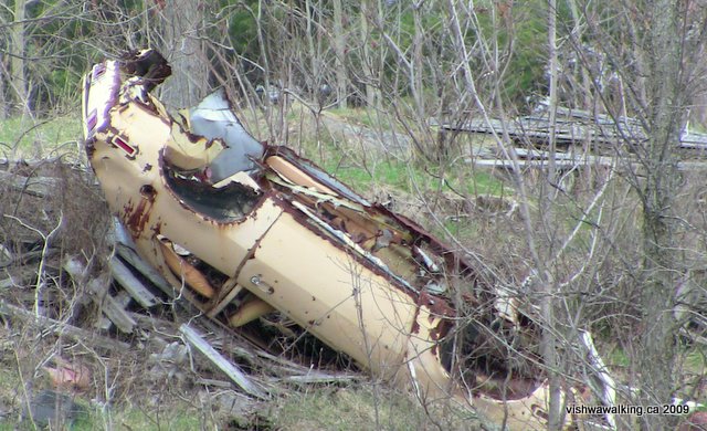
to your right at kilometre 68 and you'll see a mess of buildings and a
Toronto Transit Corporation bus. For the next three kilometres, the
human record here is not good. Shortly after the first bus, you'll see
a second TTC bus in serious disrepair; it hasn't seen the Spadina run
for many years. Beside the second bus is a run-down trailer.
Look
to your right at kilometre 68 and you'll see a mess of buildings and a
Toronto Transit Corporation bus. For the next three kilometres, the
human record here is not good. Shortly after the first bus, you'll see
a second TTC bus in serious disrepair; it hasn't seen the Spadina run
for many years. Beside the second bus is a run-down trailer.The trail comes very close to highway #7 here before angling off through a large marsh. The surface is cinder for some time, before shifting to a mix of cinder and large gravel rocks. The highway runs along the ridge to the north.
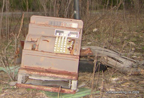
A cash register near km 68, just off the highway, near a TTC bus
As the open marsh ends, the trail enters a more wooded area, but there is still a lot of marsh about. A welcome curve and trees provide more shelter, especially if there is a brisk wind blowing. On the right, a little yellow house appears across a marshy (at least in the spring) open area and up a ridge near the highway. Around it is a mass of garbage: tires, old refrigerators and lots of plastic. I walked across the wet field to the house, thinking it was abandoned. I took several photos. Later, driving home, I noticed the house from the highway, with a couple of lights on.
The ridge to the west of the house is covered with litter. It obviously is/was a garbage dump for a couple of houses at least. The garbage stops briefly for a farm house, barn and out-buildings.
Despite the garbage, the mix of marsh and wood makes for a lively home for lots of wildlife. Ducks, beavers and other assorted animals made their presence known along the way. I walked this section on a windy day. When I paused for a second, a huge thud made me jump as a large dead branch fell from a nearby tree. Later a piece of a hubcap someone had hung on a tree branch came sailing down near my feet.
There was lots happening on this day for a remote section of the trail. The constant shuffling of the wind in the trees, the movement of branches and dead leaves, the occasional run-down house off on a ridge and the increasingly overcast skies made this an eerie walk. Several times, spooked ducks rose with a clatter from water just below the raised trail.
After the houses, a thin stretch of water runs to the right of the trail, then passes under the trail and opens into a pond that is shortly hidden by the trees, but parallels the trail for some time.
Just after the 71 kilometre point, a road heads off to the left. Shortly into the woods, it splits. The main road heads left (east), and a little road with a gate heads west.
If you skirt the gate, you'll come upon a hunting lodge. It's outer cladding is made of raw cedar shingles. The aforementioned long pond runs to the south of the lodge. If conditions were ideal, it would make an excellent skating channel.
Deer hair lies all around a tree where hunters dealt with their kill.
Back on the trail, the landscape passes between hardwood and marshland. The marshland is open, with ponds on both sides.
As you near Kaladar, the trail moves slightly north, closer to Highway #7 and the movement of traffic, as I have noted elsewhere, can make you wonder whether you should be stepping off the trail for an ATV or snowmobile.
Houses appear on your right just outside of Kaladar and then a wrecking yard on your left just before the trail adopts a bit of Station Street, an unpaved road, for few hundred feet. On your right, there's an apartment building. Strange locations these: apartment buildings in a potentially beautiful area, but the main attraction just across the road is a junkyard.
You can get to Station Street from County Road #41, just south of the trail.
The trail meets County Road #41 just south of Highway #7, where it crosses the road just short of kilometre 76. Down the hill to your right is downtown Kaladar.
Rating:
On to the next sections:
Kaladar to Tweed
Tweed to Bonarlaw
Bonarlaw to Cambellford
Campbellford
Campbellford to Hastings
Back to the Ontario Trans Canada Trail main page
Walked:
km71 to Kaladar, March 14, 2009
km68-71, April 25, 2009
km68-71, April 25, 2009
Home | Contact Us | Site Map
Page
created: April
5, 2009
Updated: September 6, 2021
Updated: September 6, 2021