About Us
Vishwawalking explained
 Ratings Explained
Vishwawalks
Parks, etc.
Funky Places
Future walks
Food
Gear
Get Lost
Good reads
Links
Right to Ramble
Site map
Contact us
Vishwawalking
Trans Canada TrailCampbellford to Hastings
9) Alma Street (Campbellford) to Woodview Road
Total: 5.7 kilometres
Running Total: 71.7 kilometres
From Grand road, head west down Alma Street. Around 2008, owners of old houses on the north side of this street were outraged that their houses might be torn down to make way for a new bridge. One of the owners was an artist, and there were prominent erections (including a five-metre cross on one lawn) obecting to the proposed bridge over the Trent-Severn Canal, between Second and Alma streets.
Here is a website from 2010 outlining what those opposed to the bridge objected to.
In August 2013, one of the chief opponents of the bridge sold his house to the municipality. The bridge at this point is a long-term project (up to 20 years away).
 One proposal on the table concerns widening the original bridge;
however the original proposal of a bridge between Second and Alma is
not off the table.
One proposal on the table concerns widening the original bridge;
however the original proposal of a bridge between Second and Alma is
not off the table.
As you walk across Grand Road, imagine a roundabout channeling traffic westward and across a brand new bridge.
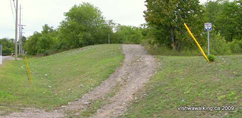
The trail heads westward at an angle at Alma and Simpson streets.
Just short of 300 metres along Alma Street at Simpson Street, you will see the trail on the north side heading off at an angle. The rail bed is easy and open here. Piles of gravel and old asphalt will be on your left.
 The
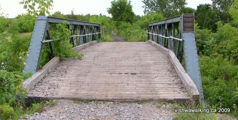
rail bed crosses Trout Creek for the first time just before Tanner
Industrial Park Road. This first bridge is dedicated to the memory of
one Keith Dunkley, who was an avid snowmobiler and member of the Percy
Boom River Rats Snowmobile Club, according to a plaque on the bridge.
The rail bed roughly follows the creek after this, crossing it
numerous times. There are eight bridges between Alma Street and
Woodview Road.
The
rail bed crosses Trout Creek for the first time just before Tanner
Industrial Park Road. This first bridge is dedicated to the memory of
one Keith Dunkley, who was an avid snowmobiler and member of the Percy
Boom River Rats Snowmobile Club, according to a plaque on the bridge.
The rail bed roughly follows the creek after this, crossing it
numerous times. There are eight bridges between Alma Street and
Woodview Road.
Most of the bridges along the section to the west of Campbellford are well
maintained, probably by the local snowmobile club. There is a little evidence
of ATVs in some sections, but none in others (yeah!).
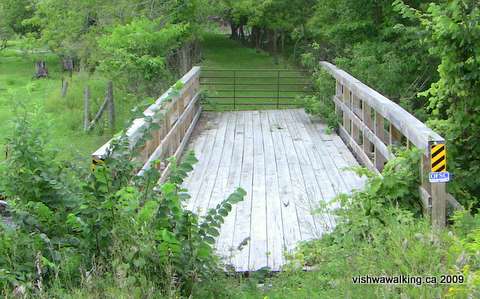
To the left at the end of Tanner Industrial Park are a number of Cooney Trailers. Shortly after you will cross bridge #2 and then Bannon Road. Just over the road, there is a bridge (#3) with a gate at the far end. It's wired closed so you'll have to climb it. On the other side is a very nice grassy trail that follows behind barns on the right and fields of cattle on the left.
 The
grassy stretch is short and you'll encounter another gate. This time
you can duck under the fence to the left. On my return walk on
this section a cow appeared on the trail a minute after I'd passed by;
she surprised me when I turned to look back.
The
grassy stretch is short and you'll encounter another gate. This time
you can duck under the fence to the left. On my return walk on
this section a cow appeared on the trail a minute after I'd passed by;
she surprised me when I turned to look back.
Beyond the gate, the trail is double-tracked here with a grassy bit in between. The overgrowth gets increasingly thicker as you go on. Keep an eye out for poison ivy; generally it is off to the margins of the trail, but there are a couple of spots where it strays to the centre.
There is a notable little copse of white birch as you leave the cattle pastures behind. The trail from this point passes through wooded areas and scrub brush sections, but you're always aware of the cultivated fields not far beyond them. County Road #30 and then #35 is also not far away to the north.
After bridges #4, #5 and #6, you'll see a green gate on the left. The trail improves here as ATVs have used it for a short stretch. I didn't encounter them directly on the trail, but on my return journey saw them messing with their machines in a field. The gate was locked on my outward journey and open upon my return, with lots of evidence of ATV presence.
After bridge #7, the ATV track turns right into a field but the trail bed continues straight on, returning to its more overgrown state. You'll pass under a power line, move through some more brush and forest before the bed opens into a field just before bridge #8, followed immediately by Woodview Road.
Rating:. (If ATVs present: )
10) Woodview Road to Hastings (north side of bridge on Bridge Street)
Total: 11.3 kilometres
Running total: 83 kilometres
At Woodview Road, the double track improves considerably. This is a well-used section by ATVs and snowmobiles. Despite this, it's a pleasant walk through woods and fields, with some curves to break the rails-to-trail monotony.
You'll cross a couple of bridges and the trail generally follows the stream/marsh. At the 2.3 kilometre point, you'll cross Godolphin Road, where there's a sign telling you about the old train stop that once was there. A little farther on, you'll see the backs of a few houses that are part of the little complex of streets that make up Godolphin. Then, three kilometres from Woodview Road, you'll pass through a tunnel that takes you under Highway #35, as the trail curves north. Notice the big sign at the mouth of the tunnel directing you to the County of Northumberland where you can find descriptions of more trails.
From here, you count up the concession roads to Hastings as you pass through a mixture of pasture, marshland and woodland. There are a couple of points on the trail that might be under water in the spring, but on my September walk all was high and dry.
Concession #11 East is 1.4 kilometres from Highway #35, and Concession #12 east another 1.4 kilometres from that. You'll catch glimpses of Bolton Road between #11 and #12, running along the edge of a ridge to your left, and the backs of a couple of farm houses on that road. Also on the left is a stretch of what looks like abandoned fields, but which might be fairly soggy these days.Some older topos show an abandoned rail line running to the right (east) of the trail; it is no longer there. I couldn't even see traces of it.
Notice the osprey nest at Concession #12 east. It was unoccupied when I passed by.Yet another 1.4 kilometres separates Concessions #2 and #13 east.
The trail now curves north-westward and the backs of the first houses/cottages lining the Trent River come in to view. As the trail curves around, there are huge bumps in a couple of spots where ATVs have spun onto the trail from the nearby road, destroying the trail in the process.
The trail crosses Friendly Acres Road (a private road) and then winds along the south shore of the Trent River. It's a good walk here generally, with houses popping up on either side occasionally, but with lots of opportunities to look at the river. At one spot, where a track led to the waterside, I watched what I thought was the back of a beaver, but then decided was a muskrat. As the forms swam closer, I realized they were two huge fish, their mouths open to catch insects on the water's surface. Unless they were suckers, this would have been an ideal time to have a fishing rod. I don't fish, but the size of these fish got me excited.
As you get closer to the town, you'll see the Hastings water filtration plant to the left of the trail. Then the trail follows just to the left of Cedar Drive before crossing it and running to the right of Water Street to the bridge. It's just short of 4 kilometres from Concession Road #13 to the bridge.
The Trans Canada Trail is suspended here. There have been no signs indicating this is the Trans Canada Trail since way back in Anson (west of Stirling) . The only indication that this is actually the trail can be found on the Trans Canada Trail website. It's unfortunate that Canada's supposedly national trail is not indicated for much of its length.
The rail bed ends here too, but picks up again outside Hastings. Even though it's not officially the Trans Canada, we'll follow it to connect again with the official trail outside of Peterborough.
How to get there: Campbellford is just under 28 kilometres north of the Highway #401 at the County Road #30 cutoff. (Brighton is signposted as being south, but you'll be heading north.) County Road #30 is 134 kilometres east from the Don Valley and Highway #401 in Toronto and 15 kilometres west of the Highway #401 Trenton cutoff.
As you come into the town, watch out for the Rotary gazebo on the right, and the Rotary trail along the Trent Canal, which will pinpoint the trail. Alma street will be on your left as you go north, just after the Canadian Tire. The Canadian Tire parking lot is a good place to park.
To get to Woodview Road, continue up County Road #30 (Grand Road). The bridge over the canal will be on your right. Turn left onto Bridge street West (this is still County Road #30) and go 2.6 kilometres. County road #30 now turns north, but stay left on County Road #35. Another 3.2 kilometres will get you to Woodview Road (a total of 5.8 kilometres from Grand Road).
To get to Hastings from Campbellford: from the bridge, head west on Bridge Street West for 2.6 kilometres, and turn left on Highway #35 (same as above to Woodview Road). Highway #35 will take you westward nine kilometres to Highway #25, where you will turn right (north) and drive another 3.1 kilometres to Highway #45. Turn right here and it's just over half a kilometre into Hastings at the junction of Water Street and Bridge Street South, just before the bridge over the canal.
You can also get to Hastings, by heading south on Highway #45 from Highway #7 at Norwood. When you get to Hastings, turn left at Bridge Street South. It's just over nine kilometres from Norwood to the south side of the bridge.
Rating:. (If ATVs present: )
Back
to
the previous section:Campbellford
Back to Bonarlaw to Campbellford
Back to Tweed to Bonarlaw
Back to the introduction
Total: 5.7 kilometres
Running Total: 71.7 kilometres
From Grand road, head west down Alma Street. Around 2008, owners of old houses on the north side of this street were outraged that their houses might be torn down to make way for a new bridge. One of the owners was an artist, and there were prominent erections (including a five-metre cross on one lawn) obecting to the proposed bridge over the Trent-Severn Canal, between Second and Alma streets.
Here is a website from 2010 outlining what those opposed to the bridge objected to.
In August 2013, one of the chief opponents of the bridge sold his house to the municipality. The bridge at this point is a long-term project (up to 20 years away).
One proposal on the table concerns widening the original bridge;
however the original proposal of a bridge between Second and Alma is
not off the table.As you walk across Grand Road, imagine a roundabout channeling traffic westward and across a brand new bridge.
The trail heads westward at an angle at Alma and Simpson streets.
Just short of 300 metres along Alma Street at Simpson Street, you will see the trail on the north side heading off at an angle. The rail bed is easy and open here. Piles of gravel and old asphalt will be on your left.
The
rail bed crosses Trout Creek for the first time just before Tanner
Industrial Park Road. This first bridge is dedicated to the memory of
one Keith Dunkley, who was an avid snowmobiler and member of the Percy
Boom River Rats Snowmobile Club, according to a plaque on the bridge.
The rail bed roughly follows the creek after this, crossing it
numerous times. There are eight bridges between Alma Street and
Woodview Road.Most of the bridges along the section to the west of Campbellford are well
maintained, probably by the local snowmobile club. There is a little evidence
of ATVs in some sections, but none in others (yeah!).
To the left at the end of Tanner Industrial Park are a number of Cooney Trailers. Shortly after you will cross bridge #2 and then Bannon Road. Just over the road, there is a bridge (#3) with a gate at the far end. It's wired closed so you'll have to climb it. On the other side is a very nice grassy trail that follows behind barns on the right and fields of cattle on the left.
The
grassy stretch is short and you'll encounter another gate. This time
you can duck under the fence to the left. On my return walk on
this section a cow appeared on the trail a minute after I'd passed by;
she surprised me when I turned to look back.Beyond the gate, the trail is double-tracked here with a grassy bit in between. The overgrowth gets increasingly thicker as you go on. Keep an eye out for poison ivy; generally it is off to the margins of the trail, but there are a couple of spots where it strays to the centre.
The bridge at Bannon Road. Notice the gate and the grassy stretch beyond.
There is a notable little copse of white birch as you leave the cattle pastures behind. The trail from this point passes through wooded areas and scrub brush sections, but you're always aware of the cultivated fields not far beyond them. County Road #30 and then #35 is also not far away to the north.
After bridges #4, #5 and #6, you'll see a green gate on the left. The trail improves here as ATVs have used it for a short stretch. I didn't encounter them directly on the trail, but on my return journey saw them messing with their machines in a field. The gate was locked on my outward journey and open upon my return, with lots of evidence of ATV presence.
After bridge #7, the ATV track turns right into a field but the trail bed continues straight on, returning to its more overgrown state. You'll pass under a power line, move through some more brush and forest before the bed opens into a field just before bridge #8, followed immediately by Woodview Road.
Rating:
. (If ATVs present: )Walked: August 28, 2009
10) Woodview Road to Hastings (north side of bridge on Bridge Street)
Total: 11.3 kilometres
Running total: 83 kilometres
At Woodview Road, the double track improves considerably. This is a well-used section by ATVs and snowmobiles. Despite this, it's a pleasant walk through woods and fields, with some curves to break the rails-to-trail monotony.
You'll cross a couple of bridges and the trail generally follows the stream/marsh. At the 2.3 kilometre point, you'll cross Godolphin Road, where there's a sign telling you about the old train stop that once was there. A little farther on, you'll see the backs of a few houses that are part of the little complex of streets that make up Godolphin. Then, three kilometres from Woodview Road, you'll pass through a tunnel that takes you under Highway #35, as the trail curves north. Notice the big sign at the mouth of the tunnel directing you to the County of Northumberland where you can find descriptions of more trails.
From here, you count up the concession roads to Hastings as you pass through a mixture of pasture, marshland and woodland. There are a couple of points on the trail that might be under water in the spring, but on my September walk all was high and dry.
Concession #11 East is 1.4 kilometres from Highway #35, and Concession #12 east another 1.4 kilometres from that. You'll catch glimpses of Bolton Road between #11 and #12, running along the edge of a ridge to your left, and the backs of a couple of farm houses on that road. Also on the left is a stretch of what looks like abandoned fields, but which might be fairly soggy these days.Some older topos show an abandoned rail line running to the right (east) of the trail; it is no longer there. I couldn't even see traces of it.
Notice the osprey nest at Concession #12 east. It was unoccupied when I passed by.Yet another 1.4 kilometres separates Concessions #2 and #13 east.
The trail now curves north-westward and the backs of the first houses/cottages lining the Trent River come in to view. As the trail curves around, there are huge bumps in a couple of spots where ATVs have spun onto the trail from the nearby road, destroying the trail in the process.
The trail crosses Friendly Acres Road (a private road) and then winds along the south shore of the Trent River. It's a good walk here generally, with houses popping up on either side occasionally, but with lots of opportunities to look at the river. At one spot, where a track led to the waterside, I watched what I thought was the back of a beaver, but then decided was a muskrat. As the forms swam closer, I realized they were two huge fish, their mouths open to catch insects on the water's surface. Unless they were suckers, this would have been an ideal time to have a fishing rod. I don't fish, but the size of these fish got me excited.
As you get closer to the town, you'll see the Hastings water filtration plant to the left of the trail. Then the trail follows just to the left of Cedar Drive before crossing it and running to the right of Water Street to the bridge. It's just short of 4 kilometres from Concession Road #13 to the bridge.
The Trans Canada Trail is suspended here. There have been no signs indicating this is the Trans Canada Trail since way back in Anson (west of Stirling) . The only indication that this is actually the trail can be found on the Trans Canada Trail website. It's unfortunate that Canada's supposedly national trail is not indicated for much of its length.
The rail bed ends here too, but picks up again outside Hastings. Even though it's not officially the Trans Canada, we'll follow it to connect again with the official trail outside of Peterborough.
How to get there: Campbellford is just under 28 kilometres north of the Highway #401 at the County Road #30 cutoff. (Brighton is signposted as being south, but you'll be heading north.) County Road #30 is 134 kilometres east from the Don Valley and Highway #401 in Toronto and 15 kilometres west of the Highway #401 Trenton cutoff.
As you come into the town, watch out for the Rotary gazebo on the right, and the Rotary trail along the Trent Canal, which will pinpoint the trail. Alma street will be on your left as you go north, just after the Canadian Tire. The Canadian Tire parking lot is a good place to park.
To get to Woodview Road, continue up County Road #30 (Grand Road). The bridge over the canal will be on your right. Turn left onto Bridge street West (this is still County Road #30) and go 2.6 kilometres. County road #30 now turns north, but stay left on County Road #35. Another 3.2 kilometres will get you to Woodview Road (a total of 5.8 kilometres from Grand Road).
To get to Hastings from Campbellford: from the bridge, head west on Bridge Street West for 2.6 kilometres, and turn left on Highway #35 (same as above to Woodview Road). Highway #35 will take you westward nine kilometres to Highway #25, where you will turn right (north) and drive another 3.1 kilometres to Highway #45. Turn right here and it's just over half a kilometre into Hastings at the junction of Water Street and Bridge Street South, just before the bridge over the canal.
You can also get to Hastings, by heading south on Highway #45 from Highway #7 at Norwood. When you get to Hastings, turn left at Bridge Street South. It's just over nine kilometres from Norwood to the south side of the bridge.
Rating:
. (If ATVs present: )Back to Bonarlaw to Campbellford
Back to Tweed to Bonarlaw
Back to the introduction
Page
created: August 30, 2009
Updated: September 7, 2021
Updated: September 7, 2021