About Us
Vishwawallking explained
 Ratings Explained
Vishwawalks
Parks, etc.
Funky Places
Future walks
Food
Gear and Health
Get Lost
Good reads
Links
Plants - Animals
Right to Ramble
Site map
Links
Contact us

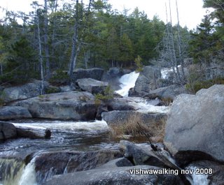
Some of the falls in the streams at the north end of the Appalachian are spectacular. In November the water is cold. Natural works of art made up of plants and ice can form along the banks.
Vishwawalking
The Appalachian Trail
For pages concerning descriptions of the Appalachian Trail on this site, please scroll to the bottom of this pageThe
trail's 85th anniversary is coming up in August, 2022!
 I
have
walked about 10 per cent of the Appalachian Trail so far. It's total
length is 2,185 miles (3,508 kilometres). Here are a few links which
may be
useful.
 I have chronicled the trail from Amicalola Falls State Park (the approach trail) to Springer Mountain, through to to Dick's Creek Gap (about 70 miles). I walked a further 130 miles to Cllingmans Dome, the highest point on the trail. I walked this in May and June, 2013.)
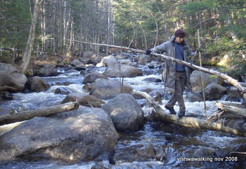
Matt (my son) crossing a rather treacherous stream on the trail south of Katahdin.
A couple of sections on this fall walk required wading and (in this situation) some
creative log-bridge building. November 1, 2008
The trail's north end is the top
of
Mount Katahdin in Maine; its south end is the peak of Springer Mountain
in
Georgia, with an 8.8-mile approach trail from Amicalola Falls State
Park to get to the start.
At the north end, Millinocket is the town to check out if you need a hotel to hang out in; alternatively you can book a campsite at the foot of Mt. Katahdin.

Through-hikers (those who take on the entire trail in one go) most often prefer starting at the south end. Hikers can start early in the year in (relative) warmth and hike north as the weather warms up. If you're coming from any distance, it's usually necessary to book a shuttle from the Atlanta airport or bus station, which will cost about $100. Alternatively you could hitchhike.
North to south the trail passes through Maine, New Hampshire, Vermont, Massachusetts, Connecticut, New York State, NewJersey, Pennsylvania, Maryland, Virginia,West Virginia, Tennessee, North Carolina, Georgia. Here's a good Wikipedia page to track the trail state by state.
Hard copy resources: Stackpole Books has separate books for different sections of the trail with excellent written descriptions of what to expect, along with detailed maps. They're in the $20 to $22 (US) range.
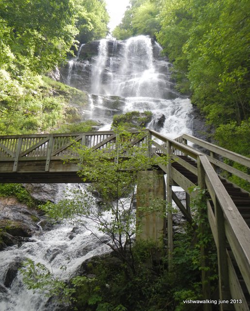
Amicalola Falls in the state park of the same name. It's 729 feet high and the tallest
falls in the U.S. southeast. There are 604 steps from bottom to top and it's a real test
of the beginning thru- or section-hiker's resolve. Most hikers tackle it in the same state
as I did: not as fit as I'd like to have been and carrying too much weight. Springer
Mountain seems far away at this point. May 24, 2013
The Appalachian Trail Conservancy produces an Appalachian Trail Data Book, which is a slim hiking-friendly booklet. It's a boiled-down version of the 11 books the Conservancy produces that have far more detail and colour. The latest (2020) version costs around $6.95US various stores. If you are an extreme Spartan you could get away with this book only if you did the rest of your research online before your walk(s). The Conservancy says it's their all-time best seller.
For the rest of us, there are the 11 guides put out by the ATC. To buy the whole lot (maps and guides) would put you out $318.50 as a non-memeber. At that price, it would be worth becoming a basic member of the conservancy ($35) and reducing the guide cost to $286.85 (US). The maps are fun, but they are not really necessary on the trail unless you're really into maps; you can always check out a general map on a rack or wall when you get into a town if you need a general orientation.
I'd guess that the most used book on the trail is David "Awol" Miller's "The A.T. Guide" (2021 edition). It's detailed enough to get you from shelter to shelter and from watering hole to watering hole, includes maps of towns along the way, has details of where to resupply, where hostels are available, and much much more. It's the guide I used and I highly recommend it.
While you're at it, get a copy of Miller's chronicle of his own thru-hiker adventures on the trail, "Awol on the Appalachian Trail." He's also got an unabridged audio copy of his book.
A good site for calculating distances can be found here, based on 2021 information.
As you pass through national and state parks, as well as private property, there are different regulations. The Appalachian Trail Conservancy has a page detaining regulations and permits.
At the north end, Millinocket is the town to check out if you need a hotel to hang out in; alternatively you can book a campsite at the foot of Mt. Katahdin.

Through-hikers (those who take on the entire trail in one go) most often prefer starting at the south end. Hikers can start early in the year in (relative) warmth and hike north as the weather warms up. If you're coming from any distance, it's usually necessary to book a shuttle from the Atlanta airport or bus station, which will cost about $100. Alternatively you could hitchhike.
North to south the trail passes through Maine, New Hampshire, Vermont, Massachusetts, Connecticut, New York State, NewJersey, Pennsylvania, Maryland, Virginia,West Virginia, Tennessee, North Carolina, Georgia. Here's a good Wikipedia page to track the trail state by state.
Hard copy resources: Stackpole Books has separate books for different sections of the trail with excellent written descriptions of what to expect, along with detailed maps. They're in the $20 to $22 (US) range.
Amicalola Falls in the state park of the same name. It's 729 feet high and the tallest
falls in the U.S. southeast. There are 604 steps from bottom to top and it's a real test
of the beginning thru- or section-hiker's resolve. Most hikers tackle it in the same state
as I did: not as fit as I'd like to have been and carrying too much weight. Springer
Mountain seems far away at this point. May 24, 2013
The Appalachian Trail Conservancy produces an Appalachian Trail Data Book, which is a slim hiking-friendly booklet. It's a boiled-down version of the 11 books the Conservancy produces that have far more detail and colour. The latest (2020) version costs around $6.95US various stores. If you are an extreme Spartan you could get away with this book only if you did the rest of your research online before your walk(s). The Conservancy says it's their all-time best seller.
For the rest of us, there are the 11 guides put out by the ATC. To buy the whole lot (maps and guides) would put you out $318.50 as a non-memeber. At that price, it would be worth becoming a basic member of the conservancy ($35) and reducing the guide cost to $286.85 (US). The maps are fun, but they are not really necessary on the trail unless you're really into maps; you can always check out a general map on a rack or wall when you get into a town if you need a general orientation.
I'd guess that the most used book on the trail is David "Awol" Miller's "The A.T. Guide" (2021 edition). It's detailed enough to get you from shelter to shelter and from watering hole to watering hole, includes maps of towns along the way, has details of where to resupply, where hostels are available, and much much more. It's the guide I used and I highly recommend it.
While you're at it, get a copy of Miller's chronicle of his own thru-hiker adventures on the trail, "Awol on the Appalachian Trail." He's also got an unabridged audio copy of his book.
A good site for calculating distances can be found here, based on 2021 information.
As you pass through national and state parks, as well as private property, there are different regulations. The Appalachian Trail Conservancy has a page detaining regulations and permits.
A few links:
How
you get to where you want to start your adventure is an ever-changing
issue, especially in the midst of the pandemic, which is when I update
this information. I found that information I posted changed so rapidly,
it was too difficult to keep up.
The
Appalachian Trail Conservancy has some links here that may help with shuttles and public transportation etc. It lists names, contact
details and some prices. (Again, the Miller book mentioned above has a
very detailed list of companies and indicviduals who will do shuttles
for cheap or for free if you use their services.
Appalachian Trail Conservancy home page.
Appalachian Trail Conservancy home page.

Here's the Appalachian Trail Conservancy interactive map of the trail. A very cool map all on one page can be found at the National Park Service. It gives you an idea of the states you'll be passing through..
Here's a great site with many online maps, including maps and data files that can be downloaded and overlaid on maps you may already have.
Peter,
standing next to Big Niagara Falls on Nesowadnehunk
Stream between Abol Bridge and Mount Katahdin.
November 1, 2008. Matt Snell photo..
Stream between Abol Bridge and Mount Katahdin.
November 1, 2008. Matt Snell photo..

For all those who have been lost in the woods or (just "turned around" for a few hours) Horace Kephart has some fine words for how you might feel: you are in a state of "bumfuzzlement" and get the "willijigs." Lots of fine outdoorsy advice here. Those Appalachian hikers passing by Mount Kephart in the Great Smoky Mountains should pause and have a thought for this great outdoorsman.
Links to pages on this site:
Appalachian Trail: History
Preparing for a long hike: some tips for the Appalachian trail
1: Southern Approach Trail (Georgia) to Stover Creek Shelter This includes the 8.8-mile trail from Amicalola Falls State Park to Springer Mountain and a 2.8 mile stretch from Springer to the first shelter.
2: Stover Creek Shelter to Neel Gap
3. Neel Gap to Dick's Creek Gap and Hiawasssee
4. Katadin
Home | Contact Us | Site Map
Page
created: August 14, 2012
Updated: May 25, 2021
Updated: May 25, 2021