About Us
Vishwawalking explained
 Ratings Explained
Vishwawalks
Day walks
Funky Places
Future walks
Food
Gear
Get Lost
Good reads
Links
Plants - Animals
Right to Ramble
Site map
Contact us

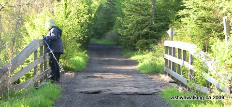
Gawley Road junction. It's not much more than a cow path here, although it's more substantial when it meets Deloro Road (County Road 11). Note the very straight trail. Get used to it.
Vishwawalking
Hastings Heritage Trail
Bonarlaw to Bannockburn
4) Bonarlaw to Highway #7
Total: 7.9 kilometresRunning total: 49.7 kilometres
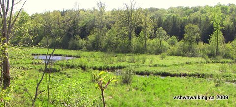
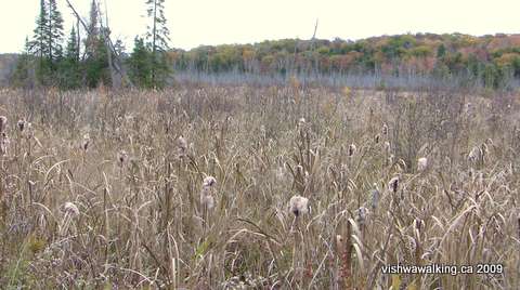
From the junction the trail runs through softwood forest with some fields to the east and marsh in places. Boulder Road (which is not indicated on many maps) ends at the trial about 500 metres from the junction. A gated road to a house and outhouses leads off left (west). Huff Road follows just short of a kilometre from the junction.
Just before Morrison Road (just over 2 kilometres), note the dead school bus off to your right. From Morrison, the trail passes through more softwood and marshy bits. Unfortunately, north of Morrison, just as you come into some pines and cedar with the beautiful smell of pine all around you, there are quite a number of old tires and other rubbish by the side of the trail.
Just before the trail crosses County Road #14 (the Stirling-Marmora Road), you get a view of the quarry to the north. Then at the road itself a yellow iron gate spans the north side of the trail; however, there's a side space for ATVs to drive through. On the north-east side of the road, the quarry disappears briefly and behind the trees fringing the trail, the area becomes much more marshy.
As the marsh to the east opens up, the trail cuts through it and there are some open spots to negotiate. At this time of year (mid-May) it was easy to walk along the edge of the water. However, I don't think this area would be negotiable earlier in the spring without a serious pair of wading boots.
As the trial curves gently to the left, the marsh to the east is studded with dead trees and open areas of water appear, and a little lake is visible to the far east. On the left is an operating quarry. On the day, I walked this section, there were trucks and backhoes running about, kicking up dust as they ground across the gravel roads. Conveyors spat out fine rock. Dire "Trespassers will be prosecuted" signs hang on the fence.
As the trail passes the northern end of the quarry, an old iron bridge spans the trail (5.5 kilometres from the junction).
Another very straight 2.4 kilometres from the bridge will get you to Highway #7. This is an interesting section , not for the trail itself (which is fairly mundane), but for the adventures you can have in the trails that branch off it.
Shortly after the bridge, a road angles northward slightly away from the trail. At most times of the year, this road is your only chance to branch eastward off the trail; marshland and open water prevent you (or at least slow you down) from doing this elsewhere. If you take the road, you'll find a cement building at the summit, with a sign warning about PCBs.
The destruction of land by the quarry has created rolling dirt and gravel areas that ATV users delight in. be warned; there were two of them raging across the terrain when i walked this section.
If you angle northeast away from the building across the flats toward the woods, you'll find a trail entering the woods. Just inside the trees, the trail branches. Take the left trail and it will lead you to Greensides Farm, an area where visions of the Virgin Mary have been seen. (I will describe this beautiful area in the Funky Places section.) Take the straight ahead trail and it will eventually lead you to a KOA campground. Both trails are beautiful; the straight-ahead trail is slightly boggy, with one major wet spot to negotiate, but nothing serious for experienced walkers. There is also a right trail that I haven't explored.
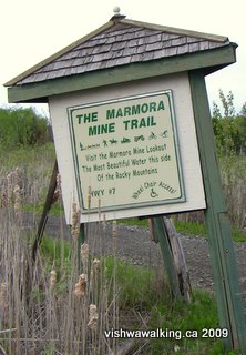 Further
down the line, about 1.5 kilometres north of the bridge, a road/trail
heads off to the west. This is the extension of Mary Street that leads
into Marmora. The "Marmora Mine Trail" is a short (just over 600 metres
long) section that leads up to the Marmora mine lookout. I've described
the Marmora Mine elsewhere. The trail
is closed to cars, but open to ATVs; west of the mine, it turns into a
regular dirt road.
Further
down the line, about 1.5 kilometres north of the bridge, a road/trail
heads off to the west. This is the extension of Mary Street that leads
into Marmora. The "Marmora Mine Trail" is a short (just over 600 metres
long) section that leads up to the Marmora mine lookout. I've described
the Marmora Mine elsewhere. The trail
is closed to cars, but open to ATVs; west of the mine, it turns into a
regular dirt road.The beauty of these links are exciting. In my description of the Marmora mine I mention a connection between the mine and the religious area I talked about above. Here's your physical connection to the two areas, through some beautiful countryside. All these areas deserve serious exploring.
To the left, before you reach the Marmora mine road, you'll get a great view of the abandoned Marmora mine buildings and the operating talc mill beside it. You get an even better view from the top of the hill, beside the concrete building I describe above.
A rather unsteady marker indicates the
road that leads west to the Marmora mine
and connects to Mary Street that leads into Marmora.
On both sides of the trail leading up to Highway #7, there is marsh. Someone has made a vague attempt to connect the "Marmora Mine Trail" (the Mary Street extension) from the east side of the marsh to the trail. It was far too watery for walking, in mid-May at least. If it did connect, there would be a more direct route to Greensides Farm; however, the diversion described above is just as good.
At Highway #7, there is an area to the north of the highway where you can park a car.
Rating:
(Lots of exciting
trails and other adventures all around this section.) EasyWalked:
May 13, 18 2009
5) Highway #7 to Malone (County Road #11/Deloro Road)
Total: 10 kilometresRunning total: 59.7 kilometres
The section to Station Drive moves through bunches of cedar trees mixed with swamp. To the north end, some rough fields open up. We (I walked this section with my wife Carol) met a farmer here, working on his fences. He said he was putting cattle into a field to the east of the trail. It looked fairly marshy. The farmer acknowledged that it was wet, but said that cattle didn't mind it and it dried up over the summer. He said that at one time hay was grown in the field, but beavers had flooded the area over the years.
Marmora Station at Station Drive, has only a house immediately west of the tracks now. A few houses lining the road some distance along.
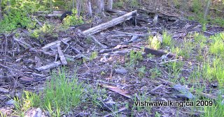 There used to be an old building just north of the
tracks at Marmora Station, the lone reminder of the station itself. I remember it when I walked this section 10 to 15 years ago.
All that remains now are some burned remnants.
There used to be an old building just north of the
tracks at Marmora Station, the lone reminder of the station itself. I remember it when I walked this section 10 to 15 years ago.
All that remains now are some burned remnants.Shortly north of Station drive, the watercourse to the east that the trail has been vaguely following crosses the trail. A small bridge makes for a good stopping point, to watch the stream as it opens up to the northwest.
 The
burned remains of Marmora Station
The
burned remains of Marmora StationThis little stream, at least in May, is impressive. I presume it's part of the Crowe Lake water system.
It meanders southward through lush marshland north of the bridge, held in by a ridge running north-south. The trail passes over the stream again roughly 1.3 kilometres north of the first bridge and bubbles narrowly through the trees to the right.
Above: the
first bridge north of Marmora Station
 Shortly after this, comes the big payoff for this walk: an
incredible little waterfall, just off the trail, pouring over the rocks
on two sides of the waterbed, with a little island in between: Niagara
Falls in miniature (and without the crowds).
Shortly after this, comes the big payoff for this walk: an
incredible little waterfall, just off the trail, pouring over the rocks
on two sides of the waterbed, with a little island in between: Niagara
Falls in miniature (and without the crowds). Shortly after the waterfall,another bridge appears and the stream opens up again on the left.
This view looks south and westward as the little stream opens up after passing
under the trail.
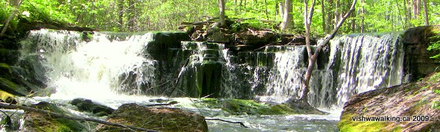
This waterfall, after the second bridge north of Marmora Station, is spectacular. This is how it looks in May; perhaps it diminishes somewhat over the summer. Nevertheless, it's worth walking a long way to experience.
Just north of the third bridge (depending upon how you count -- the second bridge is really just a little underpass) is Milk Run Road, about 4.2 kilometres from Highway #7. You can walk in to the trail on this little side road (it's not fit for cars). However, in both May and October at least, the water is at least a couple of feet deep on the side trail and very cold. I waded in from Milk Run Road (it's just under 400 metres to the road). The trail is a very pleasant one and the wade was not too onerous. Strangely, about thirty feet from the trail, a huge slab of concrete sits under the water. I wondered whether the original tracks might have been situated here, or perhaps a little building, a milk drop-off for for Milk Run Road. The trail continues on the east side, but the water looks even deeper there. I imagine you could walk/swim to Lajoie Road which is a dead-end north-south road not far to the east.
In both May and October, the section of the trail itself just north of Milk Run Road was also flooded. Again, the water was cold, but not a problem if you bring water slippers (I've done it in bare feet and the large gravel is not fun to walk on). This little water wade briefly takes the walk from "easy" to medium.
 The trail passes through mostly coniferous forests from this point, then swamps as it gets closer to Malone Road.
Some effort has been spent here to build the trail up as it passes through large expanses of swamp on either side. The swamp to the right (east) is most open. If you bicycle this section, be prepared to negotiate the large gravel rocks; the road at this point is built more to suit ATVs.
Between Milk Run Road and Deloro Road, the trail runs through mostly bush and
marsh. Here, an open section of marsh opens up to the right of the trail. Considerable work
has been done on the trail, with gravel (unfortunately with large rocks friendlier to ATVs than bicycles)
and a few underpasses for water flow.
A hunt camp is situated on the right, close to the trail. Roughly 2.8 kilometres from County Road #11, a snowmobile/ATV trail cuts east and west across the trail. A sign labels it as the Cordova Lake Trail. Cordova Lake (a fairly sizeable body of water north of Belmont Lake) is 15 kilometres to the west as the crow flies. The trail looks intriguing: rougher than the road-like Hastings Heritage Trail. A sign at the crossing indicates that Marmora is 10.9 kilometres to the south.
 As the trail closes in on Malone, fields open up, and farm houses can be seen.
 Just before Malone Road (about 500 metres from Deloro Road) look to your right; a log retaining wall runs parallel to the trail. Part of an old station? There's a bit of rubble on the hill above the wall.
Just over a fence in a field is a concrete wall, all that remains of an old building.
A wooden retaining wall on the east side of the trail just before Malone Road.
After
Malone Road a considerable amount of garbage has been dumped on
both sides of the trail and particularly behind a barn on the right. 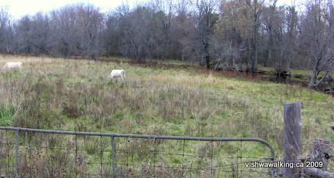 At County Road #11/Deloro Road, the trail bridge over the West Moira runs close to the bridge for the road..
 When I walked this section, cows were feeding in a nearby field, with full access to the river, a disgusting setup that should be outlawed as the animals go to the river to drink, and, of course, shit in the water at the same time.
Cattle graze in a field just off the trail near Malone. Notice the West Moira close
by. The cows have direct access to the river; here is a living example of irresponsible farming.
Look to your right when you get to the road; you'll see a rough road following the river on the east side. The river runs south-easterly at this point. Where it makes a sharp right-hand (southward) turn, you'll notice a ruined
 cottage on the river bank. It looks like some disaster hit it as it seems to be ripped in two.
We'll be running into the West Moira and its tributaries on and off from here on.
Parts of the West Moira make for interesting canoeing; I have paddled several sections around here.
The bridge to the left is for the trail; the bridge on the right is for Deloro Road.
The trail crosses the West Moira River, then, immediately to the north, meets the road.
The trail crosses the West Moira River, then, immediately to the north, meets the road.
Unfortunately I didn't chronicle my canoeing adventures adequately, so have no permanent record of of them. From the point where the trail crosses Deloro Road to Deloro, I remember placid bits interspersed with very shallow rapids. I think it was a bit of a scrape, at least in midsummer.
The trail angles across the road at this point. There is lots of space here to park your car well off the road.
Rating:
Easy, except for the water wade. (The potential for ATVs cuts this fine walk back a
rating;
the waterfall, at least in May, gets a five-dude rating. The water on
the trail can be a good thing; when I walked it, the water was definitely too
deep for ATVs, but tolerable for wading.) The section north of Milk Run Road is not as interesting as the opening section.Walked:
To Milk Run Road, May 20, 2009
Milk Run Road to Malone: October 21, 2009
7) Robinson Road, through Eldorado, north to Fox Road
Total: 4.7 km
Running total: 68.7 km
This section is really more of the same. I haven't walked this trail since 2009, but not much has changed: It is straight, with marsh and scrubby bush on either side of the trail. Sections have been "improved" often with gravel that is not friendly to bicycles. As usual, there is always the threat of ATVs.
On the other hand, if you want a walk on even ground (i.e., not a rougher woodland trail), then this is for you. This might be a fine trail for family walks, where (ATVs permitting) two and three can walk abreast
 The
signs have been updated since I walked this section of the trail in
2009. The trail maintainers still favour ATVs, but try to promote a
"multiuse trail" at the same time.
The
signs have been updated since I walked this section of the trail in
2009. The trail maintainers still favour ATVs, but try to promote a
"multiuse trail" at the same time.
From Robinson Road it's a straight walk with woods and fields on either side. Gawley Road, which you pass at just over the 700 metre mark, is little more than a track (driving it is not advised). It's hard to pick out, but a house to the south across a marsh, followed by a north-south line of trees marks the point close to where the Belleville and North Hastings Railway Company track, coming up from the south, once fed into the trail we are on. Just past the line of trees, there are a couple of cedars sitting in the swamp and you can see the curve where the old line used to run.
The updated sign advertising the trail. In the picture
and in reality, ATVs dominate, giving us an unintended
but stark visual of the ridiculousness of the term "multiuse."
You've got to love the bolt through the hikers' heads!
I've described that "trail" — one to be avoided — in my description of the extension of the Trail of Two Lakes.
Now we come to the outskirts of Eldorado, such as they are. It's a rag-tag little town pasted to the edge of Highway 62. It's claim to fame centres around a mini-gold rush that happened in the 19th century.
 At the 2.3 kilometre point from Robinson Road, the trail reaches
Highway 62. The historic plaque (pictured below) is one house south of the trail, facing
the highway.
At the 2.3 kilometre point from Robinson Road, the trail reaches
Highway 62. The historic plaque (pictured below) is one house south of the trail, facing
the highway.


You can read all about Irish farmer John Richardson's adventures in gold mining, along with other Eldorado gems on this Ontario Ghost Towns page.
A shoe tree (left) that you can admire as you come into town. It introduces us to an assortment of bricollage stashed beside the trail.
An historical plaque in Eldorado describes its glory days when a mini gold rush occurred. (below)

The old CNR station in Eldorado, once situated just to the east of the present hamlet. It no longer exists.
Photo: from the Township of Madoc website.
At one point, Eldorado's train station was a centre of some action, servicing farmers and loggers in the area.
 At the highway, walk slightly north and you'll see the trail curving off the highway and heading north.
From here it's more marsh with patches of cedar and scrub bush as the trail crosses Rimmington Road. Beyond Rimmington Road, I saw numerous mallards and a few Canada geese in the surrounding marsh.
The trail looking north on highway 62.
Milk Run Road to Malone: October 21, 2009
6)
County Road #11 (Malone) to Robinson Road
Total: 4.8 km
Running total: 64 km
 This
is a straight section of trail. North-east of Deloro Road. It has been
"upgraded," in places with gravel and stones of sometimes two
to
three inches. In spots the trail is wide enough for two ATVs and the
gravel has been placed to make motorized travel easier, especially in
marshy spots. When I walked this section, a car drove
past. It's
straight, so you can see vehicles coming from a distance.
This
is a straight section of trail. North-east of Deloro Road. It has been
"upgraded," in places with gravel and stones of sometimes two
to
three inches. In spots the trail is wide enough for two ATVs and the
gravel has been placed to make motorized travel easier, especially in
marshy spots. When I walked this section, a car drove
past. It's
straight, so you can see vehicles coming from a distance.
A barn and pond to the north of the trail and east of where the trail crosses Malone
Road. It's too small to make out, but there are ducks on the pond and pigs on the hillside.
The trail has a kind of corduroy roll to it, which makes for a bumpy ride for cyclists in places. Cycling back from a walk in the almost-dark was a bumpy ride, especially since I couldn't always see the bigger gravel rocks.
 At
the outset, it's woods to the right and fields on the left.
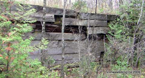
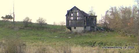
Then
woods close in until just short of Morrison Road. Check out the
falling-apart barn just to the north of the trail on Morrison. After
Morrison, the trail rides through marshland (again, gravel work
lifts the trail above the marsh) before coming out to fields at Blakely.
At
the outset, it's woods to the right and fields on the left.
Then
woods close in until just short of Morrison Road. Check out the
falling-apart barn just to the north of the trail on Morrison. After
Morrison, the trail rides through marshland (again, gravel work
lifts the trail above the marsh) before coming out to fields at Blakely.
Watch your maps. My Garmin gps map is seriously out of whack and my supposedly updated (2010) MapArt road map didn't do much better. Morrison, for example, crosses the trail; my road map shows it as ending short of the trail. Also, some maps show the track ending west of Blakely and a track road beginning. In fact, the trail is all track/road, which gets narrower as you head northeast. My Garmin Mapsource map also misplaced Blakely completely; it crosses the trail. My garmin indicates that the trail actuall becomes
The last 525 metres between Blakeley and Robinson roads is very pleasant; you can almost forget you are on a railbed. There's a house on the left just past Blakely and then farmland behind a row of trees.
Rating:
Easy.
Total: 4.8 km
Running total: 64 km
This
is a straight section of trail. North-east of Deloro Road. It has been
"upgraded," in places with gravel and stones of sometimes two
to
three inches. In spots the trail is wide enough for two ATVs and the
gravel has been placed to make motorized travel easier, especially in
marshy spots. When I walked this section, a car drove
past. It's
straight, so you can see vehicles coming from a distance.A barn and pond to the north of the trail and east of where the trail crosses Malone
Road. It's too small to make out, but there are ducks on the pond and pigs on the hillside.
The trail has a kind of corduroy roll to it, which makes for a bumpy ride for cyclists in places. Cycling back from a walk in the almost-dark was a bumpy ride, especially since I couldn't always see the bigger gravel rocks.
At
the outset, it's woods to the right and fields on the left.
Then
woods close in until just short of Morrison Road. Check out the
falling-apart barn just to the north of the trail on Morrison. After
Morrison, the trail rides through marshland (again, gravel work
lifts the trail above the marsh) before coming out to fields at Blakely.An old falling-apart barn to the
north of the trail on Morrison is worth a closer look.
Here it is viewed from the trail.
Here it is viewed from the trail.
Watch your maps. My Garmin gps map is seriously out of whack and my supposedly updated (2010) MapArt road map didn't do much better. Morrison, for example, crosses the trail; my road map shows it as ending short of the trail. Also, some maps show the track ending west of Blakely and a track road beginning. In fact, the trail is all track/road, which gets narrower as you head northeast. My Garmin Mapsource map also misplaced Blakely completely; it crosses the trail. My garmin indicates that the trail actuall becomes
The last 525 metres between Blakeley and Robinson roads is very pleasant; you can almost forget you are on a railbed. There's a house on the left just past Blakely and then farmland behind a row of trees.
Rating:
Easy.Walked:
October 17, 2009
Last 525 metres of this section walked April 18, 2013
Last 525 metres of this section walked April 18, 2013
7) Robinson Road, through Eldorado, north to Fox Road
Total: 4.7 km
Running total: 68.7 km
This section is really more of the same. I haven't walked this trail since 2009, but not much has changed: It is straight, with marsh and scrubby bush on either side of the trail. Sections have been "improved" often with gravel that is not friendly to bicycles. As usual, there is always the threat of ATVs.
On the other hand, if you want a walk on even ground (i.e., not a rougher woodland trail), then this is for you. This might be a fine trail for family walks, where (ATVs permitting) two and three can walk abreast
The
signs have been updated since I walked this section of the trail in
2009. The trail maintainers still favour ATVs, but try to promote a
"multiuse trail" at the same time.From Robinson Road it's a straight walk with woods and fields on either side. Gawley Road, which you pass at just over the 700 metre mark, is little more than a track (driving it is not advised). It's hard to pick out, but a house to the south across a marsh, followed by a north-south line of trees marks the point close to where the Belleville and North Hastings Railway Company track, coming up from the south, once fed into the trail we are on. Just past the line of trees, there are a couple of cedars sitting in the swamp and you can see the curve where the old line used to run.
The updated sign advertising the trail. In the picture
and in reality, ATVs dominate, giving us an unintended
but stark visual of the ridiculousness of the term "multiuse."
You've got to love the bolt through the hikers' heads!
I've described that "trail" — one to be avoided — in my description of the extension of the Trail of Two Lakes.
Now we come to the outskirts of Eldorado, such as they are. It's a rag-tag little town pasted to the edge of Highway 62. It's claim to fame centres around a mini-gold rush that happened in the 19th century.
At the 2.3 kilometre point from Robinson Road, the trail reaches
Highway 62. The historic plaque (pictured below) is one house south of the trail, facing
the highway.You can read all about Irish farmer John Richardson's adventures in gold mining, along with other Eldorado gems on this Ontario Ghost Towns page.
A shoe tree (left) that you can admire as you come into town. It introduces us to an assortment of bricollage stashed beside the trail.
An historical plaque in Eldorado describes its glory days when a mini gold rush occurred. (below)
The old CNR station in Eldorado, once situated just to the east of the present hamlet. It no longer exists.
Photo: from the Township of Madoc website.
At one point, Eldorado's train station was a centre of some action, servicing farmers and loggers in the area.
At the highway, walk slightly north and you'll see the trail curving off the highway and heading north.From here it's more marsh with patches of cedar and scrub bush as the trail crosses Rimmington Road. Beyond Rimmington Road, I saw numerous mallards and a few Canada geese in the surrounding marsh.
The trail looking north on highway 62.

The old closed service station in Eldorado. It's still the centre of town.
The trail generally rides slightly high north of Eldorado, with one cut through a rock outcrop, until it gets to Fox Road. Just to the east on Fox Road is a quarry with interesting rocks in it.
The trail generally rides slightly high north of Eldorado, with one cut through a rock outcrop, until it gets to Fox Road. Just to the east on Fox Road is a quarry with interesting rocks in it.
Walked April 14, 2013
8) Fox Road to Bannockburn
Total: 6.2 km
Running Total: 74.9
From Fox Road it's more of the same: fields on the left and marsh on the right. I saw a number of deer scattering across the fields at this point, heading for the woods or out of sight over the hill.
After a little wooded break, the railbed rides over a section with marsh on both sides; when I walked it in the spring, there were large open spaces of water (and some lingering ice. There are corrugated metal pipes running under the trail here, linking the marsh at points. Some of them are in poor repair; it's not a problem for walkers, unless you're a night hiker. Keep an eye out for them here.
The trail generally follows the fields/marsh pattern, with fields on the left (west), probably stretching to Highway 62. Sometimes, bits of marsh separate the fields. On the right, scrubby wooded areas occasionally break up the marsh.
At Barker Road you'll pass a house on the left, followed by fields. After passing under a one-tower set of hydro lines there's a a picturesque crumbling barn on the left. A second set of hydro lines follow, this time a four-tower set cutting through the swamp and forest. On the left, the lines pass over fields. There are the remains of a house or shed on the right at one point, with a piled-up set of tires gracing the landscape.
Barker Road North parallels the trail from Barker Road to 1.5 kilometres north, when it curves in and meets the trail. It continues at an angle off to the right. The dirt road degenerates quickly to a rough track after it crosses the trail.
After the power lines, you might notice traces of another old railbed that used to run just east of the trail. It's pretty well obliterated now, but with a little imagination, you can see bits of the raised bed running through the bush.
It's more of the same terrain to the spot where I ended the first part of this trek next to a fairly new gate three kilometres north of Fox Road (and roughly parallel with Cedar Lane on Highway #62).
I did this section in two walks and got in and out on the first day by a little road north of Keller Bridge on Highway #62. I turned left from the highway into Cedar Lane. The lane ends just a short stretch from the highway, but a trail continues. With a compass and a bit of savvy, you can follow this trail to the Hastings Heritage Trail. It's over private land and there's a sign saying no trespassing, so use your judgement. It's a pleasant trail through wood and around swamps; I actually enjoyed it more than the HHT.
From the gate, the trail generally rides high. In my late April walk, even the woods on either side were flooded, so the trail affords a good view of otherwise unwalkable terrain.
The trail curves gently toward the west. There are a couple of nice ponds, where the marshland opens to allow a bit of open water. As the trail curves first more northward, then slightly to the west again, more dirt roads and gates appear. I presume some of these landowners use the trail to get to their property. I was not plagued by any motorized vehicles, but take care — they're out there. Lots of signs abound warning of no hunting or trespassing. A peek at some of the structures down at least one of these lanes reveal remarkably civilized recently-built cottages and lawns carved out of little hills in the midst of ponds and swamp. You're on your own if you dare to defy the privacy signs.
As the trail crosses Bannockburn Road, you'll notice the highway just off to the west. There's a string of houses on Bannockburn Road and on the highway. No food store.
We'll continue north when I've built up enough miles to put up a new page. Until then...
Rating: Easy.
Total: 6.2 km
Running Total: 74.9
From Fox Road it's more of the same: fields on the left and marsh on the right. I saw a number of deer scattering across the fields at this point, heading for the woods or out of sight over the hill.
After a little wooded break, the railbed rides over a section with marsh on both sides; when I walked it in the spring, there were large open spaces of water (and some lingering ice. There are corrugated metal pipes running under the trail here, linking the marsh at points. Some of them are in poor repair; it's not a problem for walkers, unless you're a night hiker. Keep an eye out for them here.
The trail generally follows the fields/marsh pattern, with fields on the left (west), probably stretching to Highway 62. Sometimes, bits of marsh separate the fields. On the right, scrubby wooded areas occasionally break up the marsh.
At Barker Road you'll pass a house on the left, followed by fields. After passing under a one-tower set of hydro lines there's a a picturesque crumbling barn on the left. A second set of hydro lines follow, this time a four-tower set cutting through the swamp and forest. On the left, the lines pass over fields. There are the remains of a house or shed on the right at one point, with a piled-up set of tires gracing the landscape.
Barker Road North parallels the trail from Barker Road to 1.5 kilometres north, when it curves in and meets the trail. It continues at an angle off to the right. The dirt road degenerates quickly to a rough track after it crosses the trail.
After the power lines, you might notice traces of another old railbed that used to run just east of the trail. It's pretty well obliterated now, but with a little imagination, you can see bits of the raised bed running through the bush.
It's more of the same terrain to the spot where I ended the first part of this trek next to a fairly new gate three kilometres north of Fox Road (and roughly parallel with Cedar Lane on Highway #62).
I did this section in two walks and got in and out on the first day by a little road north of Keller Bridge on Highway #62. I turned left from the highway into Cedar Lane. The lane ends just a short stretch from the highway, but a trail continues. With a compass and a bit of savvy, you can follow this trail to the Hastings Heritage Trail. It's over private land and there's a sign saying no trespassing, so use your judgement. It's a pleasant trail through wood and around swamps; I actually enjoyed it more than the HHT.
From the gate, the trail generally rides high. In my late April walk, even the woods on either side were flooded, so the trail affords a good view of otherwise unwalkable terrain.
The trail curves gently toward the west. There are a couple of nice ponds, where the marshland opens to allow a bit of open water. As the trail curves first more northward, then slightly to the west again, more dirt roads and gates appear. I presume some of these landowners use the trail to get to their property. I was not plagued by any motorized vehicles, but take care — they're out there. Lots of signs abound warning of no hunting or trespassing. A peek at some of the structures down at least one of these lanes reveal remarkably civilized recently-built cottages and lawns carved out of little hills in the midst of ponds and swamp. You're on your own if you dare to defy the privacy signs.
As the trail crosses Bannockburn Road, you'll notice the highway just off to the west. There's a string of houses on Bannockburn Road and on the highway. No food store.
We'll continue north when I've built up enough miles to put up a new page. Until then...
Rating:
Easy.
Walked: April 18 and 25, 2013
Updated: July 31, 2013
Updated: July 31, 2013
More photos.
Back to the main Hastings Heritage Trail page
Back to the previous section (Glen Ross to Bonarlaw)
On to Bannockburn to Brinklow Road (Not completed yet)
Home | Contact Us | Site Map
Page
created: May 13, 2009
Updated: April 26, 2013
Updated: April 26, 2013