About Us
Vishwawalking explained
 Ratings Explained
Vishwawalks
Day walks
Funky Places
Future walks
Food
Gear
Get Lost
Good reads
Links
Right to Ramble
Site map
Contact us
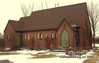
This old United Church on Moneymore Road is now a private home. February 9, 2005
Vishwawalking
Corpus Mundi (Thomasburg) Eastward (1)
Leg One: Thomasburg, Ontario, just east of Highway #37, 25 kilometres north of Belleville, to Frontenac Park
1)
Thomasburg (downtown),
down
Section total: 3 kilometres
Running total: 3 kilometres
 From Thomasburg, cross the
highway by the gas station onto the
From Thomasburg, cross the
highway by the gas station onto the
Cross the
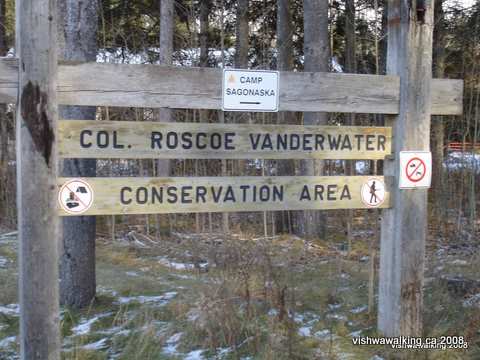
Sign at entrance to Vanderwater
Park
Photo: December,
2008
Rating:
Easy
Walked:
February
3, 2005

2)
Vanderwater Park entrance
to
Running
total: 9 kilometres
Follow the trail along the ridge above the road. About halfway through the park, it will go under some hydro lines.
 Eventually
it winds down a hill to a road. Turn sharp left at the road and
almost
immediately turn left again (don’t go down the hill to the river). Walk
down a
slight grade to where the path opens up a bit and there is a bit of
rubbish
lying around. Take the trail to the left. You will come to a fork; stay
left and follow the trail as it winds uphill and you'll see a few
houses and their back yards to your left..
Eventually
it winds down a hill to a road. Turn sharp left at the road and
almost
immediately turn left again (don’t go down the hill to the river). Walk
down a
slight grade to where the path opens up a bit and there is a bit of
rubbish
lying around. Take the trail to the left. You will come to a fork; stay
left and follow the trail as it winds uphill and you'll see a few
houses and their back yards to your left.. The trail eventually comes out on the
See the Vanderwater Park pages for a more detailed description of possible trails you can take in this section.
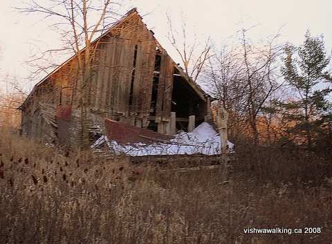
| This
old barn can be found just south of Hungerford Road. One of the trails
leading off the main trial will lead you behind some houses will lead
you to it. Just after, the trail peters out. You can then sneak through
private property, be respectable and ask permission to pass through,
or do as I did and backtrack to the main trail (see map). Photo: December, 2008 |
See
the short walks section
for a description of various trails that will get you through |
Rating (Vanderwater overall): Easy to Medium
Last Walked: December, 2008
Total: 7.4
Running total:
16.4
kilometres
 Moneymore
is a very straight paved road with a few cars dashing along. It cuts
through farmland and mostly cedar bush. There are quite a few new
houses and
several old farmhouses, both brick and wood.
Moneymore
is a very straight paved road with a few cars dashing along. It cuts
through farmland and mostly cedar bush. There are quite a few new
houses and
several old farmhouses, both brick and wood.
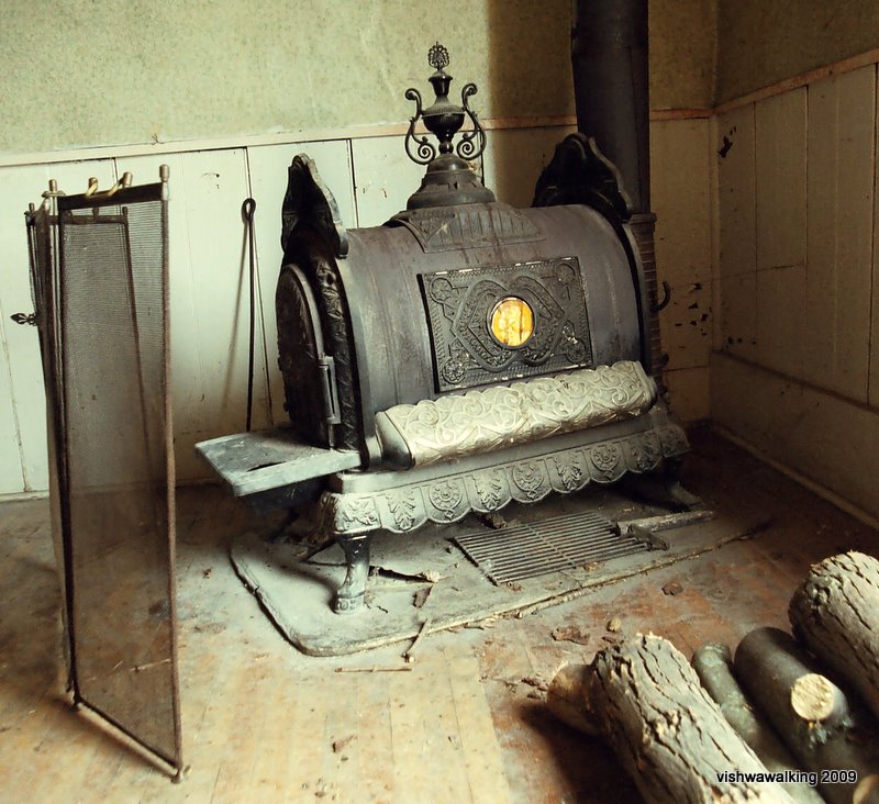
About two and a half
kilometres down the road, you'll come to Moneymore Orange Lodge, built
in 1864. It is
pretty dilapidated. The stove at left is inside the lodge.
There is one steep but not very
long hill as you travel
eastward from the lodge. At the bottom of the hill, you can see a part
of the marshland
that connects to Parks Creek, which we’ll cross on subsequent walks.
There are some interesting
farms along the way, some very stony fields and some bush.
Carlton
Farms, about a kilometre from the lodge, must be connected somehow to Robert
Carlton (1828 to 1907), who organized the first Orange Lodge in the
area in
1857A big Yogi
Bear statue
stands at the entrance of a farm on the north side.
There used to be a sign reading "Cheese Factory Lane" a the point that the lane heads off to the south. Shortly after I walked the area in 2005, the sign was broken and lay in the ditch for some time before it disappeared. There's nothing to mark it now, so watch carefully as you come over a little rise in the road. As it drops, you'll see a rough road with an iron gate thirty or forty feet from the road.
In these parts, there’s a
difference between a lane and a road. A road is public, A lane is
either private,
or it's public but the municipality has not recognized it as a road it
needs to
maintain. On my map, the road reads as "Old Cheese Factory Road."
Easy
Update: January, 2009
4)
S
Total:
3.9
Running Total: 20.3
After about 1.6 km., jog to
the west ( right) for .9 km. then south again 1.5 km. on
This is a keeper of a walk. It’s a
snowmobile trail, with evidence of
snowmobilers and perhaps ATVs, but I didn’t meet any, so all went well.
There is a tire
dump just at the end of the jog heading south again. But for that, it’s
a
beautiful point in the trail. It looks like the jog, which makes up
part of the
I saw two deer on the
Rating: Easy
(but wet spots early in the trail can be a problem)
5)
Junction of Naphan and
Total:
6.1
kilometres
Running
total: 26.4
kilometres
From Naphan (it’s on the map as a
community, but there’s only a couple of houses near the junction) walk
down Phillips
2.2 kilometres to
Rating: Easy
For more on this reserve, see my
description of the park in the link above or see the accompanying
photos here.
Total:
6
Running total: 32.4
kilometres
This
is definitely a winter walk as much of it winds
through marsh which would be impossible to negotiate in the summer. I
did the bit to Mud Lake with my wife, Carol, and my dog Ziggy.
Starting at the western entrance
(purple gate) the trail heads eastward through a planted cedar forest,
before winding to the right. A small lake appears at the .6 km. point,
where
there’s a large trailer with a bed, stove, fridge, toilet, all in bad
repair.
Also there's an RV, where people have slept in summers past, again in
bad repair. Some
pretty big heavy machinery: a crane, a couple of trucks and
two docks, one large one stuck in the ice, another flipped up just
above the
water line. My dog, Ziggy, was excited by what was probably a rabbit
hiding under the
smaller dock.
The trail behind the trailer goes
up .5 km. to what looks like a small gravel pit which
hasn’t been mined for some time, you'll run into an east-west trail.
Travelling .5 km.
eastward, the trail meets a north-south
trail. Travel south, through cedar bush then open marshy scrub, about 1
km.
You must cut sharp right just
before the main trial heads into a cedar forest. (We
overshot the trail heading
southeast just before the main trail goes back into cedar forest. After
walking
about half a kilometre, we met a family heading south(west) on
two ATVs. They told us we
had overshot the Mud Lake trail. )
It was a beautiful sunny day, only a few degrees above freezing. There was not a soul on the lake and snowmobiles and ATVs are not allowed in the actual reserve property of 2100 acres.
(We turned back at this point at about
To continue from where we left off on the west shore of Mud Lake: Walk across the lake to the clearing where the trail meets the lake, about .7 km. On the day I walked it (this time solo), the temperature was above freezing and the ice was covered in two or three inches of water. Not the most pleasant of walking conditions (very slippy and my pant legs got soaked) and there was a bit of a breeze out of the west to push me along.
From here, there's a trail that
winds to
Update: In July of 2008, the park opened a "new" trail from the gate to the lake. The trail I took in 2005, which was basically an old road, has been radically spruced up, with two wide boardwalks over particularly wet areas, numerous explanatory signs and other amenities. It's still a no-facility park, but the trail is much better and there's an excellent brochure describing the fen that makes up the park. See my description of the Menzel Reserve for more detailed information.
For the Ontario Provincial Parks link to its Menzel Park page, click here.
Rating:
Easy-medium.
Continuing eastward from Menzel Park: Thomasburg East 2
Back to the top of this pageMud Lake to Roblin Road rewalked: February 11, 2009
Updated: February 15, 2009
Page
created: February 3, 2009
Updated: July 4, 2021