About Us
Vishwawalking explained
 Ratings Explained
Vishwawalks
Parks, etc.
Funky Places
Future walks
Food
Gear and Health
Get Lost
Good reads
Links
Plants - Animals
Right to Ramble
Site map
Contact us
Vishwawalking
Bruce TrailStart: Queenston Heights to DeCew Falls, St. Catharines
(Note:
The Bruce Trail constantly has updates and occasionally
diversions. My GPS calculations of distances is based on the
walk I describe below. I use a 2008 official guidebook (edition
25). Because of changes between 2008 and now, my calculations slightly differ from the
guidebooks.
Find your way to Queenston Heights, site of the famous British-American battle of 1812, and now a park. The heights are 13 kilometres from the famous falls and 9.5 kilometres from the train station on Bridge Street in Niagara Falls.
From Niagara-on-the-Lake to the north, the heights are about 12 kilometres down the Niagara Parkway. I took a taxi to the park. The driver was slightly confused as to where the heights were, but got his bearings when I told him it was near the Queenston-Lewiston Bridge spanning the river between Canada and the U.S.
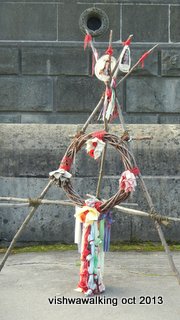
A
tribute to native chiefs who fought in the battle of 1812. See
the text for more detail.
When you get to the park, you'll want to wander about a bit, check out the monument and various other interesting sights in the park. There are a couple of walks that will take you around the park, including one that visits all the stages of the 1812 battle.
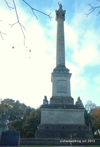
The heights are now dominated by the statue of General Sir Isaac Brock (photo above) stabbing his sword into the sky, presumably leading his troops to victory. He stands upon a huge column, which make it impossible to actually see any details of the good general.
When I was there, a small wooden tribute (above right) to two of the Indian chiefs involved on the British side in the war of 1812 was standing at the front of the monument. Some historians (such as Alan Taylor) feel that the Indian contribution was crucial and the war could not have been won without the brilliance of Tecumseh.
Attached to the the tribute were two photographs. One was of Chief Teyoninhokarawen (1760 to 1831). The other was of Chief Tecumseh (1768 to 1813).
There is a monument to Laura Secord nearby. A trail of about 45 minutes that takes you to the crucial battle sites of 1812. There's Niagara River Recreation Trail nearby that bikers might like.
When it's open, you can climb up (inside) Brock's monument and get a Brock's-eye view of the surroundings.
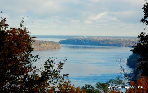 From the monument, you can look through
the trees to see the Niagara River and the U.S. side (left).
From the monument, you can look through
the trees to see the Niagara River and the U.S. side (left).Once you've had enough of the park, move to the cairn at the edge of the the parking lot below General Brock's monument, in the south-east part of the park. The cairn is not far from the Niagara Parkway that got you to the park.
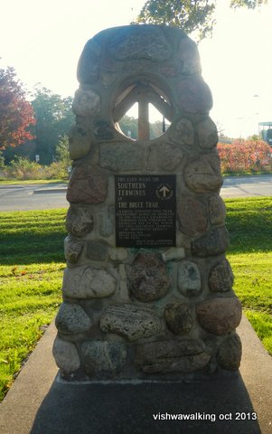
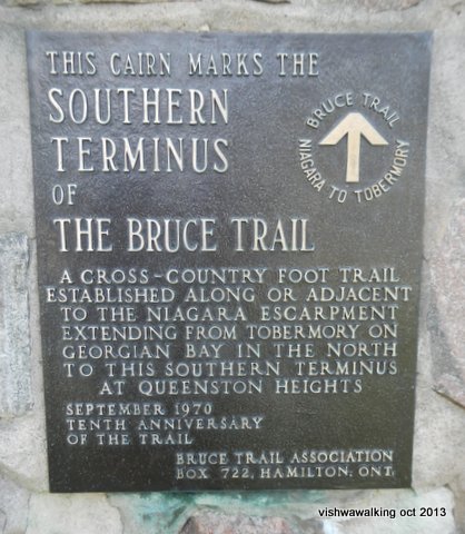
From the cairn, you can see the customs buildings on the road to the Queenston-Lewiston Bridge.
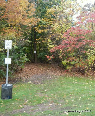 The trail cuts across the grass and
heads toward a straight line of single trees running behind a
children's playground and some covered picnic tables. After the
line of trees, the trail cuts briefly across grass to a short
paved path, then passes some work sheds before it enters the
woods. From here, the trail follows the escarpment and you can see
houses, fields and abandoned vehicles off to your right.
The trail cuts across the grass and
heads toward a straight line of single trees running behind a
children's playground and some covered picnic tables. After the
line of trees, the trail cuts briefly across grass to a short
paved path, then passes some work sheds before it enters the
woods. From here, the trail follows the escarpment and you can see
houses, fields and abandoned vehicles off to your right.This section of trail is pleasant, with a clearly marked trail and no serious ups or downs. At times the only thing reminding you that you are walking westward on a thin strip of forested area is the constant hum of traffic nearby. In the fall (late October) when I walked the trail, there was an intermittant shotgun-like booming from devices designed to frighten birds from the grape vines below.
The trail veers left at one point, with another trail going off to the right. Watch the white blazes and you'll have no trouble at all; this section is extremely well marked.
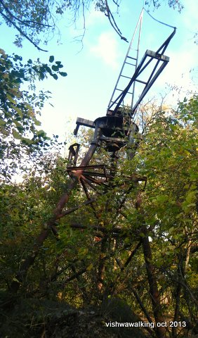 About two miles along the trail,
you'll see the old Queenston Quarry off to your left. It was a bit
muddy at this point, but nothing to worry about. You'll see some
artefacts here and there left behind by the quarry. Note the stone
foundations (mostly off to the left).
About two miles along the trail,
you'll see the old Queenston Quarry off to your left. It was a bit
muddy at this point, but nothing to worry about. You'll see some
artefacts here and there left behind by the quarry. Note the stone
foundations (mostly off to the left).An abandoned radio/microwave communications tower (left) sits right beside the trail, apparently built in the midst of the cold-war '50s.
The quarry has undergone development since I walked this section in 2013. Here's a look at the area, close to its unveiling a few years ago, in 2018.
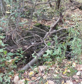
Note the holes (see photo below, mostly to the left of the trail) built with stone walls and the stones strewn beside the trail. This is the detritus from the quarry operations.
 Just after the quarry, apparently there
are some interesting caves. Unfortunately, I found out about these
after my walk. Here's a 1919 video of them with some interesting shots..
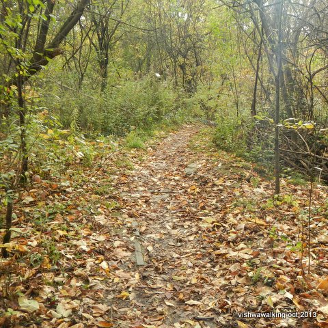
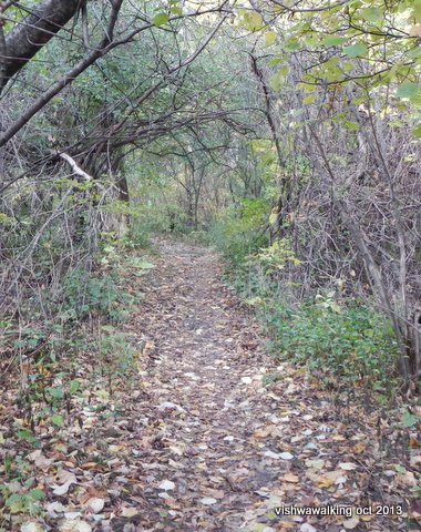
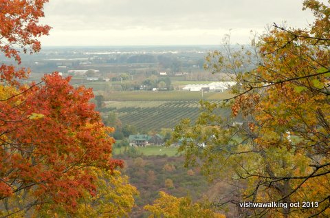
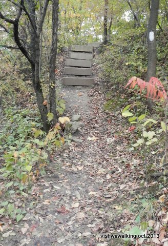
Photos:
Top left: one of the holes lined with stones to the left of the trail.
Second-from-top left and top right: Two views of the trail. it's relatively flat and open generally, moving along the top of the escarpment, although the trail will soon drop.
Bottom left: the foliage does open at a couple of places to allow a better view of the valley below.
Bottom right: A set of steps as the trail makes its first sharp drop.
Keep a watch through the trees to the fields below. There are a couple of points where the foliage breaks and you get a magnificent view (left) of the valley below and the well-laid-out farms stretching into the distance. I noticed St. David's Golf club on the map (between the three- and four-kilometre mark) , but missed it when I was walking; perhaps you'll be more attentive.
The trail veers left at one point, with another trail going off to the right. Watch the white blazes and you'll have no trouble at all. This section is extremely well marked. A couple of sections have alternate routes. This is where the trail has been rerouted briefly to avoid sharp drops or other obstructions. Again, it's well marked, so it's hard to stray from the trail if you pay attention.
There are several points where you can leave the trail to get a better view of the valley below. One is at a fence that you can skirt to get beyond the tree branches.
Just before the four-kilometre point the trail drops sharply. This is the first serious hill, but it has a switchback or two so it's not difficult.
At the four-kilometre point, you'll see the 32-kilometre Laura Secord Legacy Trail joining the Bruce from the north. A tag-end of the Upper Canada Heritage Trail also comes in here, but the latter is pretty well history as of June 14, 2013, when, after a washout, authorities decided to abandon it .
The Laura Secord Trail trail starts north of the Brock monument in Queenston at the Laura Secord Homestead. It runs to the north of the Bruce Trail until it meets the Bruce. Both trails share the path at this point as it travels south along the old New York Central Rail bed. Thus is a pleasant section, not like many rails-to-trails that are straight and flat — and often boring.
The trail winds over a wooden footbridge to come out at St. Paul's Road (also noted as Niagara Road on some maps) (5.3 km) where you will turn left (south) to walk under the bridge and up the road for roughly half a kilometre. This is a brief boring section that you will have to put up with to get to the next section. There are woods on either side of the road; I can only guess that it's private property and there are not enlightened property owners in this section. *The designation south/north etc. can be confusing. The trail in this southern section dips and loops as it winds through and around urban sections.
The trail soon heads off into the bush on the right. At the 6.7 km point (from the start) the Laura Secord trail breaks off from the Bruce. From here, the Laura Secord moves in and out from the Bruce, sometimes sharing, sometimes veering off on its own. The Bruce winds along north of the railroad tracks.
At Dorchester Road (6.9 km), the trail crosses both the road and the tracks. The Bruce guidebook says there are picnic tables here at Fireman's Park, but I didn't see any and did not want to root around finding them. There have been some reroutes here, so maybe the park is harder to find now. There are new suburbs to the north (where the Bruce used to go) so maybe the picnic tables are no more.
Once over Dorchester, you wind through bush and scrub. After the trail skirts a pond, you'll see fairly open ground to your left and the railroad to your right.
Just before Mewburn Road there's a bench (8.7 km). It's in the open without much protection. At the road, you'll see an iron bridge to your right. There are faded white blazes on the bridge. Ignore them! The bridge is closed to traffic and (technically) to pedestrians. As my guidebook was confusing here (with pre-rerouteing instructions; see the rerouteing instructions here) I blithely cruised over the bridge. Luckily a local out for a walk set me straight before I'd gone too far.
So: at Mewburn Road, clock the iron bridge, cross the road and veer right toward the railroad track. (There are signs warning you away from walking straight on into the property that features two sewage lagoons.) The trail veers left to continue following the railroad track. It's a pretty straight here, narrow at first, but it soon opens, then dips to cross a little stream. The trail almost makes a complete loop, travelling up one side of a ravine, moving almost to the Queen Elizabeth way (QEW) highway, then cutting back on the other side of the ravine before heading to the highway and across a Sand Plant Hill Footbridge (completed in 2008) (9.7 km).
From here, the trail crosses an open stretch with the railroad to the right and a field to the left, before coming to Screaming Tunnel (10 km), which passes under the tracks to Warner Road. Turn right here.
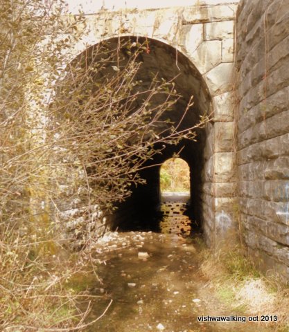 There are several legends connected
with the screaming tunnel, involving either a girl burning or
being raped in the tunnel. The tunnel was featured in a 1983 David
Cronenburg film, The Dead Zone, which is an adaptation of a
Stephen King novel. A 2012 film called Limestone
Burning plays on these legends. I couldn't find any info on
where this film is showing and the YouTube teaser did not
tease.
 On Warner Road, you will see a couple of vineyards up close, just past the tunnel.
Walk 1.4 kilometres down Warner and then turn right across a stretch of lawn (11.5 km), with houses just to your left. There's an interesting (private) back yard with a little pond and bridge just off the trail. After winding through the woods, the path emerges at a gravel road. The Laura Secord trail continues straight ahead, but you want to head down the road to the right to the Woodend Conservation Area.
This next diversion is almost a loop. You could cheat by taking the Laura Secord trail and cutting of the conservation area, but you'd be missing one of the finest parts of this section of the trail. Within the conservation area, the Paul Naray Silurian sidetrail does make a loop (using the Bruce for one part of it).
The Bruce heads off to the right just before the park's gates (12.2 km). If you want to orient yourself, you can go to the gates where there is a large map with the trails outlined. There's also a history of the park here.
Back at the main trail, the path winds down the escarpment. Notice some dramatic rock outcrops as you circle around to eventually arrive at the Woodend Environmental Centre and the eventual home of the "Walker Living Campus." The path comes close to the entrance to the houses, where you can get a glimpse of the future living campus; the proposed building looks far less attractive than the present houses.
The trail circles past an impressive wall of vertically stacked flat rocks around to the back of the main house where there is a deck with picnic tables on it. As there was not a soul about when I walked the trail, I settled in for lunch on one of the long benches around the periphery of the deck. It's a good place to stop for a while.
Beyond the houses, the trail hugs the top of the escarpment and again you should watch out for some spectacular rock formations on your right. The trail itself is flat and easy, meandering through some excellent hardwood forest. When I visited in the fall, the trees were splendidly decked out; this has to be a highlight of the first section of the trail.
The trail turns right just before it emerges back at a lower part of the road you came in on. If you overshoot the turn and have a quick look at the road, you'll see the a gate to your left and a parking lot to your right.
The trail winds along just to the right of the parking lot to the main entrance to the park at Taylor Road. Cross the road and you'll start a section of the trail that skirts the Royal Niagara Golf Club. The greens are to your right and the trail sticks mainly to the woods, occasionally emerging to cover a short bit of the paved road for golf carts.
With Hole #3 to your right, you'll walk a fairly straight section of old roadbed through what was obviously once a fruit farm. In October a few pears still clung to the trees and I had an unscheduled break to try a couple. Fallen apples covered the trail in a couple of spots.
The path now bumps into the Old Welland Canal (the Third Welland Canal, 1887 to 1931) (15.9 km), complete with abandoned locks. (Try this site for the history of the old canals.) It sticks closely to the canal until Glendale Avenue, with the golf course on the right and the water on the left. There are lots of spots where you can get clear of the bushes to get a good view of the old locks—but take care. The walls are high and it's a long drop.
At Glendale Avenue turn left (17.1 km). We are now officially in the urban part of St. Catharines. You can take a rough path that heads down over a service road, avoiding the busy bridge. Some short paths allow you to avoid the road for a brief period, but before the path descends to a stream, you have to retreat to the road.
Cross over the road into the General Motors plant and head for the bridge over the Welland Canal (17.8 km). There was construction on the bridge when I got there and it was closed to traffic, but I was allowed to walk over it.
Once over the bridge, stay with Glendale, passing over Government Road. As Glendale curves and you come to the top of the rise, curve left off the road on a paved walkway that passes through some bushes and then curves back to Welland Canal Parkway Trail alongside Government Road that follows the main Rideau Canal.
Just past the docks (on your left), you'll pass under the railway lines. Head off to your right here to an open spot where the trail cuts back toward the rails. It curves to the left until it crosses a set of tracks then heads right to a second set of tracks. Head briefly right on these tracks and you'll see the blaze on your left.
The path now connects to a third rail bed for a short while, this one abandoned and fairly overgrown. Eventually it makes a sharp left to climb a hill next to a while/grey house on Merritt Street (20 km). Cross the road to Ball Street West and walk over a small bridge with concrete rails. Continue down Ball until you come to a "Y" in the road. Take the left curve. The pavement ends, but keep on along the chain link fence until you come to an abandoned canal.
There's a little bridge here leading into a suburban area and Bradley Street. If you stand on the bridge, you can get good views of the little canal. However, don't go over the bridge, but rather follow the path to the right along a green chain link fence. This will eventually bring you out to Bradley Street. Turn right here and follow Bradley to a little park. Cut right through the park to Mountain Street, which leads to Glendale Street (21.5). This is the same Glendale we were on earlier, but farther west. The Bruce has been sharing the path with the Merritt Trail for a short while; Merritt now continues north, while the Bruce heads left (west) along Glendale.
This is a boring section of the trail, but if you need supplies or a restaurant meal, now is the time to do it. Shortly after crossing Burleigh Hill Drive and walking under the 406, you'll see the Pen Centre mall on your right. You can get supplies here. I even caught a movie at the mall, because I was camping nearby. A strange mix: to eat at Kelsey's Pub, get some camp supplies at Zehr's, watch a movie and tromp up a suburban street to a little copse where I camped.
But back to the trail. Watch out for Tremont Drive (22.2 km). You'll pass an Esso station that sits on one side of the drive. A Goodwill store is on the other and the mall is across the road. Head up Tremont and follow it as it winds its suburban way to a dead end (23.1 km). There are blazes, but make sure you stick with Tremont. The trail continues from the dead end into the woods.
There is scrubby bush on the left here and a more mature wood to the right, with the backs of suburban houses not far away. The trail climbs a bit before entering a fine open hardwood forest. It follows the escarpment around, moving across a section of land that was once the Glenridge Quarry, then a garbage dump. The area has now been "naturalized" (what a fine word!) to contain meadows and trails and other delights. Eventually the trail reaches Glenridge Avenue (24.6 km).
Turn left at Glenridge and make your way Sanatorium Hill to where the blazes tell you to head right into Brock University property (24.9 km). The trail now runs along the north edge of Brock University, occasionally emerging along a paved path behind a university building. Brock is a relatively new institution in the university game and has only been around since 1964.
The trail now curves left until it reaches an old hydro canal (26.5 km). As you walk along the fence between you and the canal, there are lots of Ontario Power Generation signs warning you not to mess around in or near the canal. At the end of the canal, with Moodie Lake (a reservoir for hydroelectric plants) opening up off to the right, the trail turns sharply left, moving onto Power House Dam Road #3, which is gravel (27.4 km). After a short jaunt down this road, with rugby fields and residences off to the left, the road curves left before turning right into the woods again (28 km).
The trail traverses a wooden walkway and then a bridge before coming to an the eastern arm of Moodie Lake. This section of the lake looks like a river. The path follows the shore to DeCew Road Bridge (29 km). Once over the bridge, the trail curves right into Decou House Park (all spellings, Decew, DeCew and Decou can be found), with the remains of Decou House off to the left of the trail.
The path now heads for the water's edge and runs along its edge until it makes a sharp left away from the water and into the bush. It's not long before it returns to the lake and curves around almost to Decew Road before cutting up to the top of a berm that runs along the edge of Moodie Lake.
When I walked this berm, the weatherman had predicted winds of 30 to 40 kilometres and hour, with gusts of up to 70 kilometres. Indeed, the wind was high and a light rain was driving into my face, so I have to say this section was not my favourite. The berm is nothing to write home about anyway, but with the weather thrown in, I confess I was not having fun. My only high point was to meet my first fellow walker, a women out strolling her dogs (see photo). At the end of Moodie Lake, the trail (thank god) turns to the left and into bush again (31.2 km). It now winds along the escarpment through the Decew Escarpment Table Lands Restoration project, with 12-Mile Creek in the valley below.
As the trail nears the creek (I am unclear whether this is 12-Mile Creek itself or an offshoot; topo maps do not help solve this one as the creek splits at one point here), you can hear the water way below in the ravine. This is a beautiful section of trail. If the day hadn't been so foul I might have risked the steep drop to get to one of the falls or rapids below. But soon the trail meets a road allowance and Decew Falls can be seen off to the right through the trees. It's a stunning falls, dropping cleanly off a dolomite ledge. As I was to find out, the falls and the diverted water to it were actually human constructions. Doesn't matter. It's impressive.
The road allowance moves around the back of a beautiful house just before the Morningstar Mill, which has been donated to the Bruce Trail Conservancy. Again, it's amazing that these rural spaces, nestled in trees with a mill nearby are also a stone's throw from a water treatment plant.
The trail curves down the hill behind the house and Morningstar Mill appears to the right (32.8 km). Try to time your walk when the mill will be open; times are somewhat vague, so it's best to call first. See the mill's website for more information. St. Catharine's website provides some historical information on the mill, as do the Friends of Morningstar.
I got lucky: the mill was meant to be closed, but I found the manager organizing the repair of the mill stones, and he gracefully gave me a tour of the building — and a ride back through the wind and the rain, so I could catch a GO train home.
Home | Contact Us | Site Map
Walked; October 22,
23, 2013
Page created: November 3, 2013
Links and some history updated: March 17, 2021
Page created: November 3, 2013
Links and some history updated: March 17, 2021